Factsaboutcharts and carriage requirements Primar Stavanger – IC-ENC
Working Group on information
(PSIWG)
1st
edition - November 2004
Kort & Matrikelstyrelsen
Graphic design: Peter M. Bastrup, KMS
This compendium may be reproduced in whole or in
part provided that all extracts quoted are reproduced verbatim
without adaptation and the source and
date are stated.
Primar Stavanger and IC-ENC
shall be indentified as
the originators of the compendium.
2
Facts about
chart carriage reguirements
CONTENTS
Introduction . . . . . . . . . . . . . . . . . . . . . . . . . . . . . . . . . . . . . . . . . . . . . . . . . . . . . . . . . .4
Where are the
rules for professional marine navigation written down? . . . . . . . . . . .6
What are the IMO requirements for the carriage of nautical charts? . . . . . . . . . . . . .6
What is a nautical chart? . . . . . . . . . . . . . . . . . . . . . . . . . . . . . . . . . . . . . . . . . . . . . . . .7
What kinds of chart and chart data are
available ? . . . . . . . . . . . . . . . . . . . . . . . . . . . .8
What are
official charts? . . . . . . . . . . . . . . . . . . . . . . . . . . . . . . . . . . . . . . . . . . . . . . . .8
What is an official ENC? . . . . . . . . . . . . . . . . . . . . . . . . . . . . . . . . . . . . . . . . . . . . . . . .9
How do I recognise an official ENC? . . . . . . . . . . . . . . . . . . . . . . . . . . . . . . . . . . . . .10
Where can I get official ENCs? . . . . . . . . . . . . . . . . . . . . . . . . . . . . . . . . . . . . . . . . . .10
How are official ENCs protected? . . . . . . . . . . . . . . . . . . . . . . . . . . . . . . . . . . . . . . . .11
What is an official RNC? . . . . . . . . . . . . . . . . . . . . . . . . . . . . . . . . . . . . . . . . . . . . . . . .11
How are charts
kept up-to-date? . . . . . . . . . . . . . . . . . . . . . . . . . . . . . . . . . . . . . . . . .12
What is
ECDIS ? . . . . . . . . . . . . . . . . . . . . . . . . . . . . . . . . . . . . . . . . . . . . . . . . . . . . . . .13
How is an ECDIS approved and by whom? . . . . . . . . . . . . . . . . . . . . . . . . . . . . . . . .14
Meeting Carriage Requirements with ECDIS . . . . . . . . . . . . . . . . . . . . . . . . . . . . . . .14
What to do in
areas without official ENC coverage? . . . . . . . . . . . . . . . . . . . . . . . . .16
What are the requirements for the
safe use of ECDIS ? . . . . . . . . . . . . . . . . . . . . . .18
What is ECS? . . . . . . . . . . . . . . . . . . . . . . . . . . . . . . . . . . . . . . . . . . . . . . . . . . . . . . . .19
Final remarks . . . . . . . . . . . . . . . . . . . . . . . . . . . . . . . . . . . . . . . . . . . . . . . . . . . . . . . .20
Normative References . . . . . . . . . . . . . . . . . . . . . . . . . . . . . . . . . . . . . . . . . . . . . . . . .20
ANNEX I Glossary/list of abbreviations . . . . . . . . . . . . . . . . . . . . . . . . . . . . . . . . . . .21
ANNEX II
Comparison of
paper charts . . . . . . . . . . . . . . . . . . . . . . . . . . . . . . . . . . .22
ANNEX III
Types of
Digital Charts . . . . . . . . . . . . . . . . . . . . . . . . . . . . . . . . . . . . . . .35
ANNEX IV IMO SN/Circ. 207
Differences between RCDS and ECDIS . . . . . . . . . .47
ANNEX V ECDIS - Procedural and organisational considerations. . . . . . . . . . . . . .49
ANNEX VI Compendium on Flag State ECDIS requirements . . . . . . . . . . . . . . . . . .53
Facts about chart carriage reguirements
3
Introduction
The
SOLAS Convention includes a requirement for all ships to
carry to up-to-date
nautical charts and publications for the intended
voyage . This carriage requirement may
be satisfied fully or partly by electronic
means .
Feed
back from people involved in the use of charts and electronic chart
display equipment covering manufacturers, distributors,
users ,
ship owners, regulatory authorities
pilots, harbour authorities and others reveal a significant uncertainty about
status and
regulations
applying to the
products and equipment available in the
market today. In
particular the differences between the status of the various types of equipment and the
differences between the various types of data offered to the users are unclear with respect
to the regulations in place.
This compendium of facts about chart carriage requirements has been compiled to serve
as a
reference frame to help resolve the uncertainties existing today.
The compendium has been compiled by the Hydrographic Offices of:
Denmark, Finland,
France (SHOM), Germany, Norway, Sweden and the United
Kingdom.
The references and
interpretation of the international regulations in this compendium
and the actual implementation as shown in Annex VI have been verified by:
• The Danish
Maritime Administration;
• The
Finnish Maritime Administration, Maritime
Safety Department ;
• The France Maritime Administration, Ministry of Infrastructure, Transport, Housing,
Tourism and the Sea, Department of Maritime Affairs and Seafarers;
• The German Ministry of Transport, Building and Housing;
• The Norwegian Maritime Directorate;
• The Swedish Maritime Adminstration, Department for Maritime Policy and Public
Affairs; and
• The United Kingdom Maritime and Coastguard Agency.
This
document does not replace or amend national or international rules and regulations.
Ship owners should always
refer to their national administrations / flag
states for the latest
information.
This compendium consists of a main document and a number of Annexes. The main
document contains a description of various aspects of charts and electronic chart display
equipment in the form of questions and answers in a short form. The main emphasis is
on what can be used to satisfy the SOLAS carriage requirements for charts.
The Annexes
contain more detailed and additional information of the
different types of
equipment and the different types of digital data available today.
Acknowledgements:
Kind assistance to ensure relevance and readability provided by:
BIMCO, Primar Stavanger and IC-ENC.
4
Facts about chart carriage reguirements
This compendium is also available at www.primar-stavanger.org and www.ic-enc.org, and
will be kept up-to-date on a
regular basis.
The editing of the compendium was completed at 25 November 2004
Definitions
A navigational electronic chart system is a general
term for all electronic equipment that is
capable of displaying a
vessel ’s
position on a chart
image on a
screen .
There are two classes of navigational electronic chart systems.
The
first is an Electronic Chart Display and Information System (ECDIS), which meets
IMO/SOLAS chart carriage requirements.
The second is an Electronic Chart System (ECS), which can be used to
assist navigation,
but does not meet IMO/SOLAS chart carriage requirements.
ECDIS:
ECDIS equipment is specified in the IMO ECDIS
Performance Standards as follows:
Electronic Chart Display and Information System (ECDIS) means a navigation information systemwhich, with adequate back up arrangements , can be accepted as complying with the up-to-date chart required by regulation V/19 & V/27 of the 1974 SOLAS Convention.Where the term ECDIS is used in this document, this is to be understood as those
navigational electronic chart systems, which have been tested, approved and certified as
compliant with the IMO ECDIS Performance Standards and
other relevant IMO
Performance standards and thus is compliant with SOLAS ECDIS requirements
ECS:
ECS is specified in ISO 19379 as follows:
ECS is a navigation information system that electronically displays vessel position and relevantnautical chart data and information from an ECS Database on a display screen, but does not meet allthe IMO requirements for ECDIS and is not intended to satisfy the SOLAS Chapter V requirements tocarry a navigational chart.ECS equipment ranges from simple hand held GPS enabled
devices to sophisticated
stand -alone computer equipment interfaced to ship systems.
Facts about chart carriage reguirements
5
Where are the rules for professional marine navigation written down?
The 1974 International Convention for the Safety of Life at Sea (SOLAS 1974),
subsequently amended in 2000 and 2002, specifies the requirements for the navigational
equipment to be used onboard ships entitled to fly the flag of a party to the convention.
This Convention was adopted by the International Maritime
Organisation (IMO), the
United Nations Organisation that is concerned with maritime transportation.
IMO member states are obliged to adopt IMO rules and regulations into their national
legislation.
However , only when the convention text has been incorporated into national
legislation does it take effect for the
individual ships registered in that country. This
process of incorporation into national legislation may vary from a few months to several
years.
The country in which a ship is registered and hence which flag it is flying is known as the
Flag State. It is the national maritime administration representing the flag state, which
controls the adherence to the SOLAS carriage requirements (Flag State
control ).
The national maritime administration is also
responsible for port state control. Ships
arriving at a port may be subject to port state control by local officials
based on flag state
regulations and international agreements. Port states cooperate
within regions to apply
consistent standards, for example the European nations and Canada cooperate under the
umbrella of the
Paris Memorandum of Understanding (MOU).
What are the IMO requirements for the carriage of nautical charts?
The requirements for carriage of nautical charts are laid down in SOLAS Chapter V.
The relevant regulations are:
• Regulation 2, defines the nautical chart
• Regulation 191, specifies the equipment to be carried on different types of ships and
• Regulation 27, specifies the requirement to
keep charts and publications up-to-date.
Applying IMO regulations in detail
The nautical charts and nautical publications
referred to in regulation V/2 are in short
called “official charts and publications”
1 Applies to ships constructed on or after 1
July 2002. Ships constructed
before 1 July 2002 may
comply with regulations V/11, V/12 and V/20 of SOLAS in force prior to 1 July 2002. Regulation V/20
contains the chart carriage requirements.
6
Facts about chart carriage reguirements
IMO SOLAS V/2:Nautical chart or nautical publication is a special - purpose map or book, or a specially compileddatabase from which such a map or book is derived, that is issued officially by or on the authority ofa Government , authorized Hydrographic Office or other relevant government institution and is designed to meet the requirements of marine navigation.IMO SOLAS V/192.1 All ships irrespective of size shall have:(…)2.1.4 nautical charts and nautical publications to plan and display the ship’s route for the intended voyage and to plot and monitor positions throughout the voyage; an Electronic Chart Display and Information System (ECDIS) may be accepted as meeting the chart carriage requirements of this subparagraph;2.1.5 back-up arrangements to meet the functional requirements of subparagraph 2.1.4, if this function is partly or fully fulfilled by electronic means;** An appropriate folio of paper nautical charts may be used as a back-up arrangement for ECDIS. Other back-up arrangementsfor ECDIS are acceptable (see appendix 6 to resolution A.817(19), as amended).IMO SOLAS V/27Nautical charts and nautical publications, such as sailing directions, lists of lights, notices tomariners, tide tables and all other nautical publications necessary for the intended voyage, shall beadequate and up to date.From the three regulations referred to in the box
above the requirements for charts and
publications to be carried can be fulfilled by
1)
Carriage of official and up-to-date paper charts, or
2)
Carriage of a type-approved ECDIS, using official and up-to-date Electronic
Navigational Charts (ENC) together with an appropriate back up arrangement.
The minimum carriage requirements for charts and publications are satisfied by the use
of paper products. After the amendment of SOLAS regulations 1 July 2002 it is
allowed to replace the paper charts and publications by electronic means if a suitable back up is
provided. Paper charts and publications continue to be the minimum requirement for
back up
purposes .
What is a nautical chart?
Nautical charts are special purpose maps specifically designed to meet the requirements
of marine navigation, showing amongst other things depths, nature of bottom, elevations,
configuration and
characteristics of coast, dangers and aids to navigation.
Nautical charts
offer a graphical representation of relevant information to mariners for
executing safe navigation.
Facts about chart carriage reguirements
7
What kinds of chart and chart data are available?
Nautical charts can be distributed in analogue form, as paper charts or digitally, as chart
data in
raster or
vector form, (see Annex III for
further technical
details ) and are available
from a variety of sources,
both governmental and private.
A raster chart is basically just a scanned and passive image of a paper chart, where a
vector chart corresponds to a digital
analysis by
object (
points , lines, areas etc.)
RASTER
VECTOR
What kinds of paper charts are there?
There are three kinds of nautical paper charts:
•
Original charts, established from hydrographic and other surveys and produced by the
relevant national authority;
•
“Facsimile” charts, are exact reproductions or copies of original charts. In some cases
however the facsimile may be ”modified” to the publishers language and adapted to
the distinct style of the publisher. In
these circumstances the hydrographic content of
the chart remains unchanged; and
•
Recompiled charts, reproduced from original charts. The recompilation may be to a
different
scale , omitting information from the original chart and
changing the
appearance of the original chart.
Recompiled and facsimile charts will be delayed in publication time compared to the
original charts. There is no synchronisation between the Notices to Mariners for the
original charts and Notices to Mariners for recompiled or facsimile charts produced by
other nations.
See Annex II for
examples .
What are official charts?
Charts issued by or on the authority of a Government, authorized Hydrographic Office
or other relevant government institutions are official and may be used to fulfil carriage
requirements (provided they are kept up to date).
All other nautical charts are by
definition not official and are often referred to as private
charts. These charts are not accepted as the basis for navigation under the SOLAS
convention.
8
Facts about chart carriage reguirements
There are two kinds of official digital charts commonly available; Electronic Navigational
Charts (ENC) and Raster Navigational Charts (RNC).
What is an official ENC?
Picture: Example from type-approved ECDIS using official ENC data.
ENC stands for “Electronic Navigational Chart”. The term was originally introduced for
digital chart data complying with the IHO chart data
transfer standard S-57. By IMO
definition ENCs can only be produced by or on the authority of a government authorised
Hydrographic Office or other relevant government institution; however the term ENC is
not protected and has been widely (and incorrectly) used by private organisations to refer
to their own products. To
avoid possible confusion the word “official” has been used as a
prefix to ENC in this document.
Official ENCs have the
following attributes:
• ENC content is based on source data or official charts of the responsible Hydrographic
Office;
• ENCs are compiled and coded according to international standards;
• ENCs are referred to World Geodetic System 1984
Datum (WGS84);
• ENC content is the responsibility of the issuing Hydrographic Office;
• ENCs are issued only by the responsible Hydrographic Office; and
• ENCs are regularly updated with official
update information distributed digitally.
See
section “Meeting carriage requirements for ECDIS”
below and Annex III for further
details.
Facts about chart carriage reguirements
9
How do I recognise an official ENC?
When you are buying:
Only authorized distributors sell official ENCs as an ENC
service , which includes the
delivery of update information. The distributors are authorized either directly by the
originating Hydrographic Office or by a cooperation of Hydrographic Offices.
When used in an ECDIS:
ECDIS distinguishes an official ENC from unofficial data. When unofficial data is used,
ECDIS informs mariners that they must navigate by means of an official up to date
paper chart by a warning, which appears continuously on the screen.
If unofficial data is shown on the ECDIS display, its boundary is to be identified by a
special line style. This boundary is visualized as a “one-sided” RED line with the diagonal
stroke on the non-HO side of the line.
Further the
mariner can use an ECDIS function to interrogate the chart display to obtain
the chart details like information on originator, edition number and status of updating.
Where can I get official ENCs?
The International Hydrographic Organisation (IHO) provides an interactive web
catalogue (www.iho.shom.fr) displaying the status of worldwide ENC
production . This
system has pointers for guiding users to ENC suppliers and distributors. A three-
colour scheme is used to distinguish between degrees of accessibility.
This catalogue indicates that a
considerable number of ENCs have been or are being
produced by Hydrographic Offices. It also shows that only a part of the issued data has
been
released and made available to the market.
The illustration below shows the front page of the catalogue, which can be
found at the
IHO web-site at www.iho.shom.fr,
look under “ENC”.
10
Facts about chart carriage reguirements
Screenshot of IHO Global ENC Catalogue, 23 november 2004
How are official ENCs protected?
A majority of all official ENCs in
Europe are only made available to the end users in a
protected form compliant with the IHO S-63 Data
Protection standard. The standard
maintains the integrity in all transactions between the service provider and the end
user .
The protection standard enables the end user systems to
check the authenticity of the
supplied information and verify that it is official ENC data. This feature can also be used
to distinguish between official ENCs and unofficial vector data in the market.
What is an official RNC?
RNC means “Raster Navigational Chart”. Official RNCs are digital raster copies of
official paper charts conforming to IHO Product Specifications RNC (S-61). By
definition RNCs can only be issued by, or on the authority of, a national Hydrographic
Office. To avoid possible confusion the word “official” has been used as a prefix to RNC
in this document.
Official RNCs have the following attributes:
• RNCs are a facsimile of official paper charts;
• RNCs are produced according to international standards;
• RNC content is the responsibility of the issuing Hydrographic Office; and
• RNCs are regularly updated with official update information distributed digitally.
Facts about chart carriage reguirements
11
The IMO performance standards for ECDIS states that where official ENCs are not
available, RNCs may be used in ECDIS to meet carriage requirements2. However, when
the ECDIS is using RNCs it should be used together with an appropriate folio of up to
date paper charts. See section “Meeting carriage requirements for ECDIS” below and
Annex III for further details.
How are charts kept up-to-date?
In
order to meet carriage requirements, official charts must be kept corrected by Notices
to Mariners issued by Hydrographic Offices.
Up-dating paper charts
The content of the “Notices to Mariners” has to be manually inserted onto the paper
chart. If the amount of
change is too large to be inserted manually, a new
version of the
chart is issued in one of the following forms:
Reprint
A reprint is an updated version of an existing chart. A reprint is
done when the
chart is out of stock, and the reprint will incorporate the latest Notices to
Mariners. The previous version remains valid if continuously
updated by Notices to Mariners.
New Edition
A new edition is an existing chart, which has been updated with information that
cannot be applied by the mariner based on Notices to Mariners. Usually a new
edition is issued when new survey information has been
included or very complex
changes to buoys and other aids to navigation etc. have been applied. A new
edition of a chart will always supersede the previous edition, which will be
withdrawn. a withdrawn chart no longer meets the carriage requirements.
New chart
Occasionally new information will
require a change of coverage or content of a
chart; in this
case a new chart of revised limits or scale will be issued. If the
previous chart has been withdrawn, it no longer meets carriage requirements.
Updating official electronic charts
Official electronic charts are kept up to date by applying regular, for example weekly,
update information to the chart data via a data file. The update file may be transferred by
wireless transmission, or by a suitable media e.g. CD. The actual updating is applied
automatically by the ECDIS to its chart database. This is the preferred update
method .
A standard function of ECDIS is the capability of updating the ENC manually on the
screen. Objects retrieved from the Notices to Mariners and applied manually to the ENC
are marked on the ENC display with an additional orange indicator.
2
IMO Resolution A817(19) as amended (1.9 and Annex 7)
12
Facts about chart carriage reguirements
How do I check that all updates have been applied to the official ENC?
Updates to official ENCs are sequential, and the sequence is
unique to each ENC. A
standard ECDIS functionality is the verification that all updates in the sequence have
been applied. Thus an indication will be
given if an update to a
specific ENC has been
missed and updating is no longer possible until this missed update is added to the
sequence.
Verification of the application of updates can be found in the list of updates already
applied, which the ECDIS is required to keep. Should all available ENCs show the
same date for the latest update, it is likely that they have not been updated regularly, and the
distributor should be contacted for verification. Furthermore it is possible to use
traditional sources of information, such as Notices to Mariners, to verify updates.
What is ECDIS?
ECDIS equipment is specified in the IMO ECDIS Performance Standards (IMO
Resolution A.817 (19)) as follows:
Electronic Chart Display and Information System (ECDIS) means a navigation information systemwhich, with adequate back up arrangements, can be accepted as complying with the up-to-date chartrequired by regulation V/19 & V/27 of the 1974 SOLAS Convention, by displaying selected informationfrom a system electronic navigational chart ( SENC ) with positional information from navigationsensors to assist the mariner in route planning and route monitoring, and by displaying additionalnavigation- related information if required.ECDIS is a ship borne navigational
device and as such it is the responsibility of IMO. It
must
support the whole range of navigational
functions that make use of the
characteristics of the chart data and their specific presentation. Moreover, to be an
ECDIS the equipment must be shown to meet all the requirements of the IMO
performance standards (IMO Resolution A.817(19)) and offer, besides the graphic
presentation of chart data, additional information about the characteristics of the
displayed features.
Within the ECDIS, the ENC database stores the chart information in the form of
geographic objects represented by point, line and area shapes, carrying individual
attributes, which make any of these objects unique. Appropriate mechanisms are built
into the system to query the data, and then to use the obtained information to
perform certain navigational functions (e.g. the anti-grounding surveillance).
The presentation of the
current position, range/bearing functions and route planning
capabilities are other examples of the minimum ECDIS requirements laid down in the
IMO Performance Standards for ECDIS.
The presentation of official ENCs on the screen is specified in another IHO standard, the
”
Colours and
Symbols Specifications for ECDIS IHO S-52”, i.e. in its Appendix 2,
called ”ECDIS Presentation Library”. This style of presentation is mandatory.
The use of official ENCs in a tested, approved and certified ECDIS and with appropriate
back up arrangements, is the only paperless chart option for vessel navigation.
Facts about chart carriage reguirements
13
How is an ECDIS approved and by whom?
To ensure that ECDIS equipment intended for onboard use is seaworthy, it must pass
type
approval and test procedures
developed by the International Electrotechnical
Commission (IEC) based on the ECDIS Performance Standards of IMO and applying
the IHO requirements, S-52 and S-57 in particular.
Type approval is a method to show conformance with IMO requirements on a
legal base – it is initiated and required by all flag states, which are Member States of the
European Union and by many others outside
including United States, Japan and
Australia. ECDIS type approval is the certifications process that ECDIS equipment must
undergo before it will be
considered to comply with the IMO Performance Standards for
ECDIS by the international shipping community.
Type approval is normally conducted by recognized organisations or by marine
classification societies nominated by Flag States. Some maritime nations also have type
approval programs within their maritime safety administration or Department of Marine
Transportation. European Governments within the European Union have agreed about
mutual recognition of their ECDIS type approval certificates – indicated by the so-called
“Wheel Mark” sign of conformity - by the so-called Maritime Equipment Directive.
At the request of IMO, the IEC established the operational methods of
testing for an
IMO-compliant ECDIS. For each of the sections contained in the IMO Performance
Standards for ECDIS, IEC developed appropriate test requirements, procedures and
required test
results .
Recognized organisations are making use of this test standard to conduct their type
approval process.
This also applies to each of the various ECDIS related specifications provided in the
current versions of IHO S-52 and IHO S-57 and associated appendices. The IEC ECDIS
Test Standard is contained in IEC Publication 61174. In
addition IEC 61174 refers to the
application of other test standards to an ECDIS. In particular to IEC 60945, containing
general requirements for robustness of the device against environmental influences and
for software design, and IEC 61162 for data interfacing.
Meeting Carriage Requirements with ECDIS
Only a type approved ECDIS
operating with up to date official ENCs and with
appropriate back up may be used to replace all paper charts on a vessel.
Where official ENCs are not yet available, IMO regulations
allow Flag States to authorise
the use of official raster charts (together with an appropriate folio of paper charts) - see
section below.
In all other cases the vessel must carry all paper charts necessary for its intended voyage.14
Facts about chart carriage reguirements
From the regulatory perspective, the most important statement about the legal status of
ECDIS is contained in the amended Chapter V of the SOLAS Convention set into force
on 1 July 2002. ECDIS is specifically referred to in Regulation 19 ”Carriage
requirements for ship borne navigational systems and equipment”. See
fact box in section
“What are the IMO requirements for the carriage of nautical charts” above.
However, in order to replace paper charts, such systems must fulfil considerable technical
requirements:
• The chart data in use must be official (i.e. official ENCs where available);
• The graphic display on the screen must meet the equipment-independent specification;
and
• The equipment must support the
full range of navigational functions that can be
performed on the traditional paper charts.
Back up requirements
No electronic system is completely failsafe. IMO Performance Standards therefore
require that the ”overall system”
include both a
primary ECDIS and an adequate
independent back up arrangement that provides:
• Independent
facilities enabling a safe take over of the ECDIS functions in order to
ensure that a system failure does not
result in a critical situation; and
• A means to
provide for safe navigation for the remaining part of the voyage in case of
ECDIS failure.
However, these
rather basic statements allow considerable leeway and there are various
interpretations as to what are the minimum functional requirements, or what constitute
”adequate” back up arrangements.
IMO added Appendix 6 to the performance standards for ECDIS back up requirements,
which lists the required functions and availability requirements of back up arrangements,
including;
• Chart information using the latest official edition that are kept up-to-date for the entire
voyage;
• Route planning capable of performing route planning functions, including taking over
the route plan of the primary system, and adjusting a planned route;
• Route monitoring enabling take-over of the route monitoring function originally
performed by the primary system, including plotting own ship’s position and displaying
the planned route; and
• Voyage recording that keeps a record of the ship’s actual
track , including positions and
corresponding times.
The definition of these key functional requirements
still leaves open what technical
solutions constitute adequate back up arrangements.
Options for back up arrangements
There are a number of possible options that could meet these requirements, including:
• A second ECDIS connected to an independent power supply and a separate GPS
position input;
• An appropriate up-to-date folio of official paper charts for the intended voyage;
• An ECDIS operating in the RCDS mode of
operation ; and
Facts about chart carriage reguirements
15
• A
radar -based system called ”Chart-Radar” according to IMO Performance Standards
for Chart Radar3.
At the date of publication of this document, there is no common interpretation of what
types of back up arrangements are acceptable by the different national maritime
administrations.
For this reason ship owners should consult their national maritime administration for
specific advice.
A compendium of different maritime administrations’ accepted back up arrangements are
found in Annex VI.
What to do in areas without official ENC coverage?
In 1998 the IMO recognised that it would take some years to
complete the world’s
coverage of ENCs. As a consequence IMO ECDIS Performance Standards were
amended adding a new optional mode of operation of ECDIS, the Raster Chart Display
System (RCDS) mode4. In this mode RNCs can be used in ECDIS to meet SOLAS
carriage requirements for nautical charts. However, this is only allowed if approved by the
Flag State. The intention of those changes was to allow the ECDIS to operate as far as
possible on official chart data; official ENCs where they were available and official RNCs
to fill in the gaps.
IMO took note of the limitations of RNCs as compared to ENCs5, and the revised
ECDIS Performance Standards require that the ECDIS must be used together with “an
appropriate folio of up-to-date paper charts” for the areas where RCDS mode is
employed. The intention was to allow the number of paper charts carried by a vessel to
be reduced where RCDS mode was employed, but only to a level compatible with safe
navigation. No definition of an “appropriate folio” was provided by IMO and
consequently different Flag States developed individual interpretations.
As there is no common interpretation of the term “appropriate” ship owners should
consult their flag state as to whether RCDS mode is allowed and under what
conditions .
In areas where ENCs or RNCs are not available vessels must carry all paper
charts necessary for the intended voyage.
See Annex VI for specific implementation by a number of maritime administrations.
3 IMO Resolution A477(XII), as amended by MSC64(67)
4
IMO Resolution A.817 (19) as amended; 1.9 and Appendix 7
5
See IMO SN/Circ.207 in Annex IV for further details
16
Facts about chart carriage reguirements
Does your ECDIS system Meet Carriage Requirements?
ECDIS Carriage Requirements – a summary
Are Official ENCs
YES
NO
YES
NO
available for area
of operation?
What Digital
Official ENC
Official RNC
Official RNC
Private
Charts are being
(coverage at an
(coverage at an
charts (6)
used in the ECDIS
appropriate scale
appropriate scale
by the mariner?
for navigation)
for navigation)
What back up system Independent ECDIS
Independent ECDIS
None None
is required?
or other back up
or other back up
required (3)
required (3)
solution required
solution required
What are the
None needed (1)
An “appropriate”
All up to date
All up to date
requirements for
(except if back up is
folio of up to date
papercharts
paper charts
the carriage of
a folio of
paper charts to be
required
required for
Official paper
paper charts)
used in conjunction
for safe
safe navigation
charts?
with the ECDIS
navigation
for the intended
in RCDS mode
in areas where
voyage
ENCs are
available
How is the ECDIS
As an ECDIS
As an ECDIS in
As an ECDIS in
As an ECS
Operating ?
RCDS mode
RCDS mode
Does the ECDIS
YES (1)
YES (2)
NO (4)
NO(5)
fulfil Chart
Carriage
Requirements?
Notes to table above:(1) Some Flag States may require specific documentation to allow this. (2) Requires approval of vessel’s Flag State – Flag State defines meaning of ‘appropriate’(3) Back up system is only required if ECDIS is intended to meet carriage requirements (4) For ECDIS to fulfil Carriage requirements vessels must use ENCs where these are available(5) Paper charts (not the ECDIS) must remain the primary means of Navigation(6) If private charts are used in an ECDIS the system is regarded as operating as an ECS. ECDIS operating as ECS, ECS systemsmeeting RTCM standards or Private charts meeting ISO standards being used in ECDIS do not meet carriage requirements. Acceptance of ECDIS by port state control
Ships arriving at a port may be subject to port state control by local officials based on
flag state regulations and international agreements.
In Europe the port state control acts on the regulations set out in the Paris Memorandum
of Understanding. Its ECDIS guidelines explain how a port state control Officer (PSCO)
should assess whether a ship is using electronic charts in accordance with SOLAS
requirements. Checks may include whether:
• The ship has documentation indicating that the system complies with IMO
Performance Standards for ECDIS. In the absence of such documentation, the PSCO
should seek confirmation from the Flag State that the system does meet the statutory
requirements;
• The system is being used for primary navigation. It should be established if ECDIS is
Facts about chart carriage reguirements
17
used in the ENC mode or RCDS mode or in both modes;
• There are written procedures onboard the vessel for using ECDIS;
• The master and watch-keeping Officers are
able to produce appropriate
documentation that generic and type-specific ECDIS familiarisation has been
undertaken;
• The charts used for the intended voyage are the latest official editions;
• The charts in use are updated; and
• There are approved back up arrangements available to ensure a safe transfer of the
ECDIS functions in the event of ECDIS failure and to provide safe navigation for the
remaining part of the voyage.
What are the requirements for the safe use of ECDIS?
The safe use of ECDIS requires the mariner to be trained and appropriate
bridge procedures to be established.
What are the requirements for ECDIS training?
The STCW (Standards of Training, Certification and Watch-keeping) and ISM
(International Safety Management) codes put the responsibility firmly on the shipowner
to ensure that mariners on their vessels are competent to carry out the duties they are
expected to perform. If a ship is fitted with ECDIS, the shipowner has a duty to ensure
that users of such a system are properly trained in the operation and use of electronic
charts and are familiar with the shipboard equipment before using it operationally at sea.
There is no specific regulation or reference to ECDIS systems in the STCW Convention.
However, since ECDIS systems are related to electronic charts, references about
them are
considered to be included in the material covered by the word “chart”:
• Following the functional
approach , the Officer in charge of navigational watch must
have
“thorough knowledge of and ability to use navigational charts and publications, […]”;• The methods for demonstrating competence are
“using chart catalogues, charts,navigational publications, […] electronic navigation equipment […]”;• Criteria for evaluating competence are stated as
“The charts selected are the largest scale suitable for the area of navigation and charts and publications are corrected in accordance
with the latest information available”; and• Finally, a candidate for certification must provide evidence of skills and ability to
prepare for and conduct a passage,
“including interpretation and applying information
from charts”.To encourage effective ECDIS education, the IMO approved a standardised model
course for ECDIS training on the operational use of ECDIS in 1999 (IMO course 1.27).
This course is offered by approved training institutions and maritime academies.
Maritime administrations can provide information on approved institutions. Some flag
states have developed their own training courses in ECDIS in order to be able to
recognise the training certificates.
Type specific ECDIS training is provided by equipment manufacturers.
18
Facts about chart carriage reguirements
What are the ECDIS operational considerations?
Navigating with ECDIS is fundamentally different from navigating with paper charts.
The ECDIS changes the way
work is done on the bridge of a vessel. This requires careful
analysis of the facilities and specifications of the installed equipment, hereunder the
navigational sensors and the data they acquire and of the rules and regulations applicable
to the system and its use in navigation in particular. It requires that the need for new
bridge procedures is analysed in view of the change of work processes introduced by the
equipment and it requires an appreciation of the human element.
A list of bridge work-processes that are affected by changing to an ECDIS, and which
may require that procedures are amended or developed is found in Annex V. This list
includes some points for analysis and
consideration .
What is ECS?
All systems, which are not tested to show compliance with the ECDIS Performance
Standards, can be generically designated as ”Electronic Chart Systems” (ECS). An ECS
may be able to use either official ENCs, RNCs or other chart data produced privately
and could have functionality
similar to ECDIS.
Some ECS equipment manufacturers also produce vector and raster data to use in their
products. These suppliers have been producing private chart data for a number of years
and have established themselves in the market. They were the pioneers and have
established the idea and the use of electronic chart systems on vessels. Their charts are
derived from Hydrographic Office paper charts or Hydrographic Office digital data.
Hydrographic Offices do not take any responsibility for the accuracy or reliability of
privately produced charts.
Where the vessel operates with ECS, the paper chart remains the official basis for
navigation onboard. The vessel must retain and use a full folio of up-to-date paper charts
onboard, regardless of the type of electronic charts used.
Because ECS is not intended to meet SOLAS requirements, there are no IMO
Performance Standards6 for ECS.
6 The International Organisation for Standardization (ISO) has developed a Standard for ECS
databases (=ECS Charts). Document ISO 19379. The Radio Technical Commission For Maritime
Services (RTCM) has developed a recommended Performance Standard for ECS (=ECS
Equipment). RTCM Paper 100-2002/SC109-STD. None of these standards are recognized by the
IMO.
Facts about chart carriage reguirements
19
Some ECS manufacturers also use the term RCDS to
describe their systems. In this case
the manufacturer is stating that the system uses RNCs and possibly that it has the same
functionality as required by the ECDIS Performance Standards. However, such systems
cannot be used to meet carriage requirements.
The STCW and ISM codes put the responsibility firmly on the shipowner to ensure that
mariners on their vessels are competent to carry out the duties they are expected to
perform. If a ship has ECS fitted, the shipowner has a duty to ensure that users of such a
system are properly trained in the operation and use of electronic charts, are aware of the
limitations compared to ECDIS and are familiar with the shipboard equipment before
using it operationally at sea.
Final remarks
This document is a first version of an information document aimed at giving the
international shipping society a compendium, which provides factual information on
chart carriage requirements, paper charts and digital charts and chart display equipment.
It is intended to up date and
develop the document further.
Feedback from the readers of this document will be welcomed in the continuing process
of improving the contents.
Feedback may be adressed to any of the Hydrographic Offices listed in the Introduction.
Normative References
• International Convention for the Safety of Life at Sea (SOLAS), 1974 as amended
• IMO Resolution A817(19): Performance Standards for ECDIS;
• IEC 61174 (2001-10): Electronic chart display and information system (ECDIS) -
Operational and performance requirements, methods of testing and required test
results
• IEC 60945: Maritime navigation and radiocommunication equipment and systems –
General requirements – Methods of testing and required test results;
• IEC 61162: Navigation interfaces – Methods of testing and required test results;
• IHO S-57: IHO Transfer Standard for Digital Hydrographic Data, edition 3.1;
• IHO S-52: IHO Colour and Symbols Specifications for ECDIS, edition 4.2;
• IHO S-61: IHO Product Specification for Raster Navigational Charts, edition 1.0;
• IHO S-62: IHO Codes for producing Agencies; and
• IHO S-63: IHO Data Protection Scheme, edition 1.0.
20
Facts about chart carriage reguirements
ANNEX I Glossary/list of abbreviationsAbbreviation
Explanation
AIS
Automatic Identification System
ARPA
Automatic Radar Plotting Aid
ECS charts
Non official (private) chart data (vector or raster)
ECDIS
Electronic Chart Display and Information System.
ECS
Electronic Chart System (non complying with SOLAS requirements)
ENC
Electronic Navigational Chart
GPS
Global Positioning System
Hydrographic Office
National Hydrographic Office.
IC-ENC
International Centre for ENCs, RENC operated by UK Hydrographic
Office
IEC
International Electrotechnical Commission
IHO
International Hydrographic Organisation
IMO
International Maritime Organisation
ISM
International Safety Management Code
ISO
International Organization for Standardization
NtM
Notices to Mariners
MoU
Memorandum of Understanding
Primar Stavanger
RENC operated by Norwegian Hydrographic Office
PSC
Port State Control
PSCO
Port State Control Officer
RCDS
Raster Chart Display System
RENC
Regional ENC Coordination Centre
RNC
Raster Navigational Chart
RTCM
Radio Technical Commission for Maritime Services
S-52
IHO’s special publication No. 52. IHO Colour and Symbols Specifications
for ECDIS
S-57
IHO’s special publication No. 57. IHO Transfer Standard for Digital
Hydrographic Data
S-61
IHO’s special publication No. 61. IHO Product Specification for Raster
Navigational Charts
S-62
IHO’s special publication No. 62. IHO Codes for producing Agencies
S-63
IHO’s Special publication No. 63. IHO Data Protection Scheme
SATCOM
Satellite
Communication SENC
System ENC
SOLAS
IMO’s convention for Safety Of Life At Sea
WEND World ENC Database
WGS84
World Geodetic System 1984
Term
Explanation
Validation
Process which aims to secure that an ENC is produced
according to IHO standard S-57
BIMCO
Worlds largest Association of shipowners and others
representing more
than 65% of worlds tonnage
Facts about chart carriage reguirements
21
ANNEX II Comparison of paper chartsThere can be several paper chart series issued officially i.e. by or on the authority of a
government, for a given geographic area. There is normally only one original series; all
others are some form of
copy of the original. There is normally no coordination between
the different governments’ paper chart series and no synchronization of the update
frequencies.
The original series are most often produced by the coastal state, but some coastal states
have arrangements with other states to produce the original chart series covering their
waters. Examples are France for parts of the Pacific and some parts of the African coast
and Indian Ocean, the Netherlands for parts of the Caribbean, the United Kingdom for
parts of the Atlantic and Indian Oceans.
Three nations produce and maintain a worldwide chart series. These are the Russian
Federation, the United Kingdom and the United States of America. A number of other
nations produce chart series that
cover an area somewhat larger than their own territorial
sea and the immediate adjacent water areas. Examples are France, Japan and Germany.
Except for areas where these nations are producing original chart series, all charts within
their series are either facsimile or recompiled versions of the original charts.
In the modification process changes to the original scale, content and choice of colours may
take place. Delays are likely to appear between the
issue of a new edition of the original
chart and the corresponding modified copies. There may also be delays between the issue of
Notices to Mariners for the original charts and those produced for the derived charts series.
Below are a number of examples of an original chart and three modified copies, which
illustrates the variation in the way the chart information is presented. Finally a new
original chart of the same area based on new information.
The examples are in sequence:
• FI 903. Finnish general chart “Saaristomeri - Skärdgårdshavet“. Scale 1:200 000.
Originally published in 1940, newest edition in 2002. No NtM corrections included.
• BA 2297. British Admiralty general chart “Gulf of Bothnia – Saaristomeri and Ålands
hav”. Scale 1:225 000. The first edition published in November 1984, newest edition in
May 2003. NtM corrections included up to 30/2907/ 2004
• BSH 1300. German general chart “Finnische Küste – Åland-Inseln und Turku-
Schären”. Scale 1:200 000. The first edition published in March 1981, newest edition
in August 2003. NtM corrections included up to 33/2003.
• RU 22059. Russian general chart “Baltic Sea – Port Turku (Abo) to Saaremaa”. Scale
1:250 000. The first edition published in July 1995, newest edition in June 2001. NtM
corrections included up to August 2002.
• FI 952. Finnish general chart “Baltic Sea - Gulf of Finland. Läntinen Suomenlahti –
Västra Finska Viken”. Scale 1:250 000. The first edition published in November 2003.
No NtM corrections included.
Chart FI 903 is the source of the three derived charts. To assist in the comparison a square
has been drawn on all examples.
Items to
compare within the squares are a.o. amount of detail, choice of symbols and line
styles. The same comparison should be made towards the new chart of the same area, FI 952.
22
Facts about chart carriage reguirements
ANNEX II Comparison of paper chartsFI 903. Reproduced by
permission of the Finnish Maritime Administration,
Hydrographic Department.
Facts about chart carriage reguirements
23
ANNEX II Comparison of paper chartsBA 2297. Reproduced from Admiralty chart 2297 by permission of the controller of
Her Majesty’s Stationary Office and the Hydrographic Offices of Finland, Sweden and
the United Kingdom (www.ukho.gov.uk).
24
Facts about chart carriage reguirements
ANNEX II Comparison of paper chartsBSH 1300. Reproduced by permission of Bundesamt für Seeschiffahrt und
Hydrographie.
Facts about chart carriage reguirements
25
ANNEX II Comparison of paper chartsRU 22059. Reproduced by permission of the Head Department of Navigation and
Hydrography.
26
Facts about chart carriage reguirements
ANNEX II Comparison of paper chartsFI 952. Reproduced by permission of the Finnish Maritime Administration,
Hydrographic Department.
Facts about chart carriage reguirements
27
ANNEX II Comparison of paper charts28
Facts about chart carriage reguirements
ANNEX II Comparison of paper chartsFacts about chart carriage reguirements
29
ANNEX II Comparison of paper charts30
Facts about chart carriage reguirements
ANNEX II Comparison of paper chartsFacts about chart carriage reguirements
31
ANNEX II Comparison of paper charts32
Facts about chart carriage reguirements
ANNEX II Comparison of paper chartsFacts about chart carriage reguirements
33
ANNEX II Comparison of paper charts34
Facts about chart carriage reguirements
ANNEX III Types of Digital ChartsOfficial electronic chart data
Official electronic chart data are of two general types:
• Official Electronic Navigational Charts (ENC), and
• Official Raster Navigational Charts (RNC).
The inner construction of ENCs and RNCs is fundamentally different:
• ENCs are vector charts, and
• RNCs are raster charts.
The term “Official” (Official ENCs, Official RNCs), indicates that those chart data have
been produced under the authority of a government – in contrast to private, i.e. non-
official electronic chart data which might be technically of the same type but have been
produced without the authority of a government.
Official Electronic Navigational Charts (ENC)
General principles
IMO’s definition for the Electronic Navigational Chart – ENC:
ENC means the database, standardized as to content, structure and format , issued for use with ECDISon the authority of government-authorized Hydrographic Offices.The ENC contains all the chart information useful for safe navigation, and may containsupplementary information in addition to that contained in the paper, which may be considerednecessary for safe navigation.Official ENCs are vector charts compiled from a database of individual geo-referenced
objects from Hydrographic Office’s archives including existing paper charts.
When used in an ECDIS, the ENCs content can be displayed as a seamless pattern in
user selected scales presenting user selected chart items. Due to the limited physical size
and the limited resolution of computer monitors the chart image generated from ENCs
does not fully imitate the known appearance of the paper chart. This apparent
disadvantage is compensated by the ENC being a database: special ECDIS operational
functions continuously retrieve the ENC content to give warning of impending
danger in
relation to the vessel’s position and its movement.
ENC Data Format
In order to facilitate the world-
wide uniformity of ENCs issued by different bodies, the
IHO Special Publication S-57 “IHO Transfer Standard for Digital Hydrographic Data” is
used. S-57 generally describes the standards to be used for the exchange of digital
hydrographic data between national Hydrographic Office’s and for the distribution of
digital data and products to manufacturers, mariners, and other data users.
The current version 3.1 (2004) of S-57 is not limited to ENC
compilation , but the
included description of the ENC data format, the ENC product specification and the
ENC updating profile are the most important parts of the standard as it stands today.
World Geodetic System 1984 (WGS 84) are being used a reference frame in all official
ENCs and for GPS as well.
Facts about chart carriage reguirements
35
ANNEX III Types of Digital ChartsENC Visualisation
An ENC contains an abstract description of geographic entities but does not contain any
presentation rules. All presentation rules to get the ENCs content displayed are
contained in a separate ECDIS software module - the “Presentation Library”.
Both the geo-referenced objects contained in the ENC and the appropriate symbolisation
contained in the Presentation Library are linked to each other in the ECDIS only when
called up for display. The resulting image will differ depending on the selected sea area,
the intended display scale and the mariner’s pre-settings like ambient
light conditions and
other operational conditions.
The definition of the Presentation Library for ENCs is contained in Annex A of the IHO
Special Publication S-52, Appendix 2 “Colours & Symbols Specifications for ECDIS”
(current edition 3.3/2004) and is mandatory for all ECDIS.
The strict separation between the Hydrographic information contained in the ENC,
operational information taken from navigation sensors and their situation related
presentation by means of the Presentation Library gives the flexibility to display the
diversity of ECDIS information, e.g.: physical chart information, (e.g. coastline, depth
contours, buoys),
• Physical chart information, (e.g. coastline, depth contours, buoys);
• Traffic routeing; specified areas; cautions; etc.;
• Supplementary Hydrographic Office information from light list, etc.;
• Mariner's notes; additional local chart information; manufacturer's information;
• Chartwork such as planned route; electronic bearing lines and range rings etc.;
• Own ship's position and course/speed vector; ship's heading and
rate of turn; past
track;
• Fix accuracy, or position check from secondary positioning system;
• Possibly, shiphandling options, based on ship's characteristics;
• Alphanumeric navigation information (ship's latitude, longitude, heading, course, etc.);
• Information from radar and other sensors,
• Information from AIS;
• Navigational indications and alarms generated by ECDIS;
• Possibly, telemetered information from shore authorities, (traffic, real-time tides etc.);
• Possibly, ice information;
• Reminders, (e.g. time to contact pilot station); and
• Possibly, a message from other displays (e.g. alarm on engine room display).
Because much experience is embodied in the paper chart, and to avoid confusion in the
extended period
while paper charts and RNCs as compared to ENCs co-exist, the two
presentations should be similar wherever possible.
The ECDIS Presentation Library follows that of the paper chart to the widest extent
possible. However, studies and early experience indicated that good visual
communication between the ECDIS display and the user requires more flexibility of
display than is available from paper charts. Consequently some alternative display
methods are being introduced as options in the Presentation Library, e.g.:
36
Facts about chart carriage reguirements
ANNEX III Types of Digital Charts• Displaying/removing various types of chart and non-chart information;
• Selecting standard chart display or a thinned out display, and full or simplified
symbols;
• Using cursor interrogation for further detail;
• Overlaying/removing radar video or radar target information (in order to: confirm
ship's positioning; aid radar interpretation; show the entire navigation situation on one
screen);
• Overlaying/removing various other sensor information, or information telemetered
from shore;
• Changing the scale or orientation of the display;
• Selecting true motion or relative motion;
• Changing screen layout with windowed displays, text information in the margins, etc.;
• Possibility of pull-down menus and other operator interaction devices being alongside
the operational navigation display and so interacting with it;
• Giving navigation and chart warnings such as "too close approach to safety contour";
"about to enter prohibited area"; "overscale display"; "more detailed (larger scale) data
available" etc.;
• Possibly, a diagrammatic representation of a computer evaluation of grounding danger;
• Possibly, a diagrammatic representation of the immediate vicinity of the ship to aid in
close quarters manoeuvring; and
• Other future developments. (Further presentation requirements and techniques
appropriate to ECDIS are likely to be developed in future).
Probably no other display application is as demanding as that of ECDIS. Since colour is
a prime means of distinguishing features, the maximum range of colours should be
available. However, the colours selected must be such that they can be clearly
discriminated by a mariner with no more than adequate colour
vision , and colour
induction effects must be avoided (for example a small green object on a saturated blue
background will
tend to appear yellow).
The ambient lighting on the bridge varies between the extremes of bright sunlight, which
washes out information on the display, and
night , when the light emitted by the display
has to be low enough that it does not
affect the mariner’s night vision.
The colour and
symbol specifications of S-52 have been designed to meet these difficult
requirements rather than less demanding normal day conditions. Because the ECDIS
display uses emitted light, compared with reflected light for the paper chart, ECDIS must
switch to a negative image of the chart at night, using a dark background in place of the
white background of the paper chart, in order not to impair night vision.
Three predefined different colour schemes are therefore provided:
• Day (white background)
• Dusk (
black background)
• Night (black background)
Below are illustrated two different colour schemes and the three standard selections of
content i.e. Standard Display, Base Display and Full Display.
Facts about chart carriage reguirements
37
ANNEX III Types of Digital ChartsStandard Display, DAY
Standard Display, NIGHT
38
Facts about chart carriage reguirements
ANNEX III Types of Digital ChartsBase Display, DAY
Full Display, DAY
Facts about chart carriage reguirements
39
ANNEX III Types of Digital ChartsUse of ENCs in ECS
It should be noted that many ECS are able to use official ENCs.
ENC Distribution
The provision of a timely, reliable worldwide uniform ENC data distribution service is a
major organisational challenge. The IHO developed the WEND (World-wide Electronic
Navigational Chart Database) concept to meet these requirements. WEND consists of
two components:
• A charter describes the principles governing the cooperation between Hydrographic
Offices e.g.:
• By definition, the organisation responsible for charting of an area is also responsible
for the ENC production;
• The relevant standards, especially S-57 must be observed; and
• The rules of a recognised work quality assurance system (e.g., ISO 9000) should be
applied to data production.
• A conceptual schema describes a
network of regional centres.
• Each so-called Regional Electronic Chart Co-ordinating Centre (RENC) takes over
the responsibility in its area for the collation of ENCs and up
dates for the
region ;
•
Through the exchange of the regional datasets and their updates between all RENCs
each RENC can offer an identical global dataset for ECDIS; and
• RENCs do not
deliver ENCs directly to ships. RENC customers are commercial
chart data distributors who - in analogy to paper chart distribution - tailor individual
sets of chart data for the special needs of a shipping company or a particular ship.
To date, two RENCs – Primar Stavanger, based in Norway and IC-ENC, based in the
United Kingdom, are in operation. However, it has to be noted, that the WEND concept
has not been fully adopted through all ENC producing nations yet. A number of nations
are still distributing their ENCs individually (e.g. Japan Hydrographic Office, Australian
Hydrographic Office, USA - NOAA) either through chart data suppliers or directly.
Principally, WEND focuses on the supply and distribution of ENCs by facilitating the
establishment of services intended to satisfy the SOLAS carriage requirement for up-to-
date charts. Within this primary purpose, ENCs are to be distributed in the encapsulation
described in the S-57 Standard. However, such “plain” S-57 encapsulated ENCs may
become easily subject to unauthorised amendment or illegal copying.
IHO has therefore issued the special publication S-63 “IHO Data Protection Scheme” as
Standard for protection of ENCs by encryption.
Encryption is a complex technical procedure: S-63 defines security constructs and
operating procedures for the RENCs/chart data distributors and provides specifications
that allow navigation equipment manufacturers to build S-63 compliant ECDIS. S-63 is
already in use for ENC distribution and is supported by the noted two RENCs. Most
major ECDIS manufacturers have implemented decryption procedures in conformance
with S-63 within their systems.
40
Facts about chart carriage reguirements
ANNEX III Types of Digital ChartsWhat is a SENC?
An ECDIS does not process the ENC content directly for the matter of display. ENCs in
S-57 format are optimised to absorb the Hydrographic object information but this
structure is not adequate for the fast generation of the resulting computer image on the
screen.
In order to get efficient data structures that facilitate the rapid display of ENC data,
ECDIS firstly converts each ENC from S-57 ENC format into an internal format called
SENC – System ENC – which is optimised for chart image creating routines.
Such routines are not standardised; they are part of the individual software
know -how of
the ECDIS manufacturers. Consequently the SENC format differs between the ECDIS
of different manufacturers. In contrast to the common uniform ENC format the SENC
format is proprietary for each ECDIS manufacturer.
SENC delivery
The WEND system has established an optional distribution mechanism called SENC
delivery. This is in addition to the standard ENC distribution. In this case, the RENC
delivers the ENCs to a chart data distributor who then performs the ENC-to-SENC
conversion (that otherwise would have to happen inside the ECDIS), and deliver the
SENCs to the end user.
However, it is up to the individual Hydrographic Offices to decide whether they allow the
ENCs for their waters to be distributed in SENC format.
To the date of this publication SENC delivery has only been accepted by a few nations.
It is possible for the ECDIS to determine if the SENC data being displayed is from either
an official ENC or a private source by use of the Agency Code (a two
character combination which is unique for any data producer) embedded in the data.
Using this code the ECDIS is able to
inform the mariners that they must navigate with an
official up to date paper chart if SENC data from a private source is in use. The ECDIS
will show a warning on the ECDIS screen:
«No Official Data - Refer to paper chart »
What scale should an official ENC be displayed at?
During production, official ENCs are assigned a compilation scale based upon the nature
of the source data they are based on, and are allocated to a navigational purpose
band related to this. As shown in the table below there are 6 navigational purpose bands (scale
ranges are indicative only).
Facts about chart carriage reguirements
41
ANNEX III Types of Digital ChartsNavigational Purpose
Name
Scale Range
1
Overview
1:4 000
Table: Suggested assignment of navigational purposes to scale ranges
For the future, to facilitate the display of radar video over official ENCs, it is
recommended that the Hydrographic Offices set the compilation scales of their official
ENCs to be consistent with the standard radar range scales as shown in the following
table:
Selectable Range
Standard scale (rounded)
200 NM
1:3 000 000
96 NM
1:1 500 000
48 NM
1:700 000
24NM
1:350 000
12 NM
1:180 000
6 NM
1:90 000
3 NM
1:45 000
1.5 NM
1:22 000
0.75NM
1:12 000
0.5 NM
1:8 000
0.25 NM
1:4 000
table: Radar range / standard scale
How are official ENCs named?
Each official ENC is identified by an 8 character identifier e.g. FR 501050. The first two
characters indicate the producer e.g FR for France, GB for Great Britain (a complete list
of producer codes is included in the IHO standard S-62). The third character (a number
from 1 to 6) indicates the navigational purpose band (as shown in the table above). The
last 5 characters are alpha- numeric and provide a unique identifier.
Updating ENCs
In principle the generation and distribution of regular updates uses identical
organisational structures as for the production and distribution of ENCs described above.
Their frequency is usually synchronised with the chart corrections promulgated with
national Notice to Mariners for the affected sea areas.
Updates may reach the ship via different
ways depending from the capabilities of the
service provider and the communication facilities onboard:
• On data distribution media, e.g. CD;
• As e-mail attachment via SATCOM; and
• As broadcast message via SATCOM plus additional communication hardware.
42
Facts about chart carriage reguirements
ANNEX III Types of Digital ChartsResume of main characteristics of official ENCs
• Vector data in IHO S-57 format ;
• Are referred to WGS 84 ;
• Issued by Hydrographic Offices or on behalf of them ;
• Flexible visualisation provided through the Presentation Library (S-52);
• Unauthorised changes or illegal copying is avoided by use of the S-63 protection
scheme;
• SENC delivery is an alternative distribution method of ENC content in a proprietary
ECDIS manufacturer format; and
• Regular updates are provided via data distribution media or wireless via SATCOM.
Official Raster Navigational Charts (RNCs)
General principles
Official RNCs are digital copies of paper charts conforming to IHO special publication
S-61 Product Specifications for Raster Navigational Chart (RNC) that are issued by, or
on the authority of a national Hydrographic Office.
When displayed on an ECDIS screen they appear to be a facsimile of the paper chart
however, they contain significant metadata to ensure that they have certain minimum
functionality; e.g. a means for geo-referencing positions on the chart, automatic updating
of the RNC from digital files (and the ability to show the state of correction) and the
display of the RNC in day or night colours as appropriate.
As a digital copy of the original paper chart, a RNC has no intelligence and other than
visually, cannot be interrogated for e.g. automatic route checking or hazard warnings;
however some of these limitations can be minimised by manual user input to the ECDIS.
RNC data format and production
RNCs are normally produced by digitally scanning the stable colour bases used in the
multi -colour printing process. Unlike ENCs there is not a single accepted format for
RNCs. The main formats are
• BSB (used by USA, Canada, Cuba and Argentina), and
• HCRF (used by UK, Australia and New Zealand).
RNC Visualisation
• RNCs are designed to be displayed at the same resolution as that which they are
provided. Excessive zooming in or out of the same image seriously degrades the RNC
image. RCDS allows charts of appropriate scale to be displayed; when the user wants
to zoom in then a larger scale chart will be displayed and similarly on zooming out a
smaller scale chart will be used;
• Orientation of the RCDS display to other than north-up (e.g. course-up or route-up),
may affect the readability of chart text and symbols;
• RNCs incorporate very similar colour palettes to the day/night colours used by ENCs.
It is mandatory for RCDS to have the capability to use different colour palettes;
• RNCs are treated as individual charts (not seamless like ENCs). However, it is possible
for ECDIS to automatically load adjoining chart based on the
meta data provided;
• ARPA radar targets can be overlaid onto an RNC. It is also possible for a radar video
image to be scaled to fit the RNC. Scaling the RNC to fit the radar video image is
Facts about chart carriage reguirements
43
ANNEX III Types of Digital Chartsunsatisfactory as this is likely to result in a degraded chart image; and
• RNCs include significant meta data to allow the ECDIS to make maximum use of the
image. For example chart notes and tide panels may be accessed directly by the RCDS
rather than the user having to scroll to the appropriate area of the chart.
RNCs maintain the horizontal datum of the paper chart from which the RNC has been
derived. Mariners should
understand , how the chart horizontal datum relates to the
datum of the position fixing system. In some instances, this may appear as a shift in
position. (Any differences will be most noticeable at grid intersections and during route
monitoring). Where the
difference between the local horizontal datum and WGS 84 is
known, an adjustment should be automatically applied by the ECDIS.
Below are illustrated Day and Night colour schemes af a RNC
RNC Display, DAY
44
Facts about chart carriage reguirements
ANNEX III Types of Digital ChartsRNCDisplay, NIGHT
RNC updating
• Updates can be supplied as complete refreshed images or as patches (tiles or areas)
that the RCDS can superimpose on the original RNC. The latter method is normally
used as this minimises the amount of data to be provided;
• Updates are provided in line with those made available for the equivalent paper chart;
and
• Most RNC services currently rely on CD as the transfer media.
Resume of main characteristics of official RNCs:
• Digital copies of paper charts geographically referenced and including additional
meta-data to allow RCDS usage;
• Familiar chart display;
• Issued by Hydrographic Offices according to IHO S-61 Standard;
• Most routine navigation tasks achievable on the paper chart can be accomplished with
the use of RNCs in RCDS; and
• Updates are regularly supplied in line with the paper chart.
IMO has issued SN Circ.207 illustrating the functional differences between ECDIS and
RCDS modes, see Annex IV.
Facts about chart carriage reguirements
45
ANNEX III Types of Digital ChartsNon-official/private chart data
From the general point of view the types of non-official/private chart data are similar to
official chart data:
• Private vector chart data, and
• Private raster chart data.
Data produced by private data manufacturers are not controlled by an official body.
Private chart data format and production
There are differences in the type and quality of data being sold. While many companies
take care in the production of electronic chart data to ensure both completeness and
accuracy, this cannot be assumed for all.
In 2003 ISO issued a specific standard for private chart data; this standard was produced
on the initiative of the industry: ISO 19379 applies to both private vector charts and to
private raster charts. Chart data certified according to ISO19379, is now available on the
market.
Chart data published by private companies is entirely under the product liability of the
producing company. The responsibility and product liability for official charts rests with
the government of the producing nation.
Private chart data, regardless of the format in which it is supplied to the market does not
meet the requirements specified by the IMO Performance Standards for ECDIS.
In contrast to ENCs and RNCs there are many proprietary formats used. Consequently,
chart data from different manufacturers are incompatible with each other – and so are
the ECS which make use of them.
Examples of private vector charts :
Examples of private raster charts:
C-Map CM93
Maptech,
LiveChartB
Mapmedia,
BlueChart
NDI,
C-Map NT+
SoftChart
Transas TX-97
Navionics Gold
Navicarte
46
Facts about chart carriage reguirements
ANNEX IV IMO SN/Circ. 207 Differences Between RCDS and ECDISFacts about chart carriage reguirements
47
ANNEX IV IMO SN/Circ. 207 Differences Between RCDS and ECDIS48
Facts about chart carriage reguirements
ANNEX V ECDIS - Procedural and organisational considerationsNavigating with ECDIS is fundamentally different from navigating with paper charts.
The table below lists a range of bridge work-processes that are affected by changing to an
ECDIS system, and which may require that procedures are amended or developed. The
table includes some points for analysis and consideration.
It is not implied that all items mentioned should result in corresponding written
procedures, nor is it implied that the list in any way is conclusive.
Procedure
considerations
Voyage Planning
Voyage Planning is different on an ECDIS compared to a paper chart. There are
a number of available features, such as safety contours, alarms, click-and-drop
facilities for waypoints and markers, etc. While it is still possible to make
errors in Voyage Plans (VPs) they are likely to be different in type from the
errors most frequently observed on paper charts. Consideration should be
given to developing a “
best practise” for ECDIS VPs.
Issues such as which chart types are available in the ECDIS for the segments of
the voyage should be considered. The process analysis should also cover the
situations where vessels are operating ECDIS in addition to traditional paper
charts, where VPs are drawn on paper charts as well as programmed on the
ECDIS.
The VP format should be considered. The existing formats in use may not have
been drawn up with ECDIS in mind, and a VP format produced by the ECDIS may
not fulfil the needs of the company. How should an ECDIS VP be backed up
during voyage execution, in case the ECDIS must be reset or the navigation
sensors fail?
Approval of VPs
VP validation or approval presents another set of new considerations.
Validating a VP made on an ECDIS is different from validating a paper chart
based plan. The plan may also have to deal with issues such as the planned
settings of the equipment and the alarms. It requires a different mindset to
review a paper plan than it does to review a plan made on a computer. It is
comparable to the difference between reading a complex paper on a PC
compared to reading papers in hard copy.
Communication to
VP presentation or communication to other Officers must
other Officers
also be considered.
Once a VP has been prepared and approved it should be
communicated to the other Officers. The communication of the VP will in
many ways be similar to the approval. However, it is an issue, which requires
separate attention to ensure that all bridge Officers are properly prepared
for the intended voyage. Communication of the VP could cover the
presentation to the bridge Officers at the beginning of the voyage as well as
the Officer’s review of the part of the voyage likely to be sailed during a
watch.
Voyage execution
The voyage execution impacts on various bridge procedures, and the
consequence of the new procedures introduced with the ECDIS should be
analysed and appreciated. It concerns e.g. issues such as the changing of the
watch and the settings of the equipment.
Facts about chart carriage reguirements
49
ANNEX V ECDIS - Procedural and organisational considerationsProcedure
considerations
Sharing of VPs
VPs may be stored and shared between several users or ships. It is possible for
an Officer with a few keystrokes to print and
present a complete and
comprehensive VP – possibly made for a vessel with different characteristics.
VPs can be
sent ashore for approval or for the creation of a VP bank.
Although the sharing of VPs may be economically attractive, there may be
legal and other considerations
Both paper charts
Where vessels carry an ECDIS in addition to a paper charts.
and ECDIS in use
In those situations the role of the ECDIS and the charts should be considered.
If the ECDIS is used for real time navigation, the statutory requirements
regarding monitoring of the progress of the voyage and marking of positions
should be considered.
E.g.
•
are positions marked in paper charts solely for record keeping purposes?
•
what steps are taken to ensure that intended tracks marked on the paper
charts correspond with the ECDIS information?
•
are all persons concerned with the navigation of the vessel using the same
equipment according to the bridge procedures?
Until all the world is covered by ENCs, it is most likely that most vessels to
some
degree will have to operate a dual – or triple – system with paper, raster
and vector charts.
Change of watch
It should be possible for the Officer taking over the watch to look through
the intended track on an ECDIS in preparation to take over the watch at the
same time as the equipment is in use for manoeuvring in confined water or in
dense traffic conditions.
Considerations should include:
•
the degree of details regarding the settings of the equipment to be covered
in handing over the watch,
•
the amount of time to be allocated to the change of watch,
•
the considerable number of possible settings on an ECDIS which often
requires that a range of sub-menues are called up,
•
whether the verification of settings above impacts on the availability of the
system for navigation purposes.
Standard ECDIS
Consideration should be given to which ECDIS settings shall be
Settings
dictated by the bridge procedures, and which settings should be left to the
Officer to decide upon. For most settings the degree of freedom and the level
of authority should be considered, for instance in relation to the following
items:
•
Statutory requirements
•
Corporate procedures and guidelines
•
Master’s standing orders
•
VP recommendations
•
Officer of the Watch preferences
•
Day or night
50
Facts about chart carriage reguirements
ANNEX V ECDIS - Procedural and organisational considerationsProcedure
considerations
Human elements
The human element must also be appreciated. While young navigators will
often be quick to explore the ECDIS and learn the details, the older and more
experienced senior officers may be more reluctant users.
The danger is that electronic navigation becomes an exercise that is
controlled by those with a flair for computers rather than those with
experience in navigation. On the other hand young officers may rely too
much on the electronic systems, and forget to cross check the information
given. Procedures and training programmes may be designed to accommodate
these concerns.
The degree of familiarisation training required for the various staff positions
onboard should be considered. The approval of a VP requires equivalent
knowledge of the system to that expected of the person doing the planning.
What level of familiarisation is required of a newly assigned watch officer
before that person is allowed to stand individual watches?
Auditing
Vessels are audited by internal and external parties. How is it ensured that the
company’s internal auditors can verify that the system is set up and operated
in accordance with the corporate plans?
What training is needed for the auditors and superintendents?
Are ECDIS auditing and inspection procedures required?
Facts about chart carriage reguirements
51
52
Facts about chart carriage reguirements
ANNEX VI Compendium on Flag State ECDIS requirementsCompendium on
Flag State ECDIS
requirementsPresent version
25 November 2004.
Facts about chart carriage reguirements
53
54
Facts about chart carriage reguirements
Facts about chart carriage reguirements
55
56
Facts about chart carriage reguirements
Facts about chart carriage reguirements
57
58
Facts about chart carriage reguirements
Facts about chart carriage reguirements
59
60
Facts about chart carriage reguirements


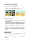
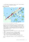
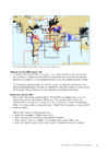


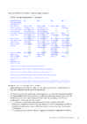


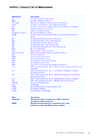

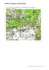
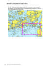
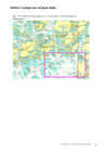
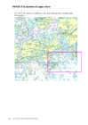
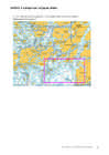


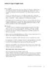
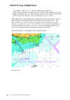
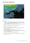


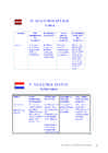


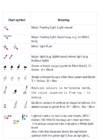


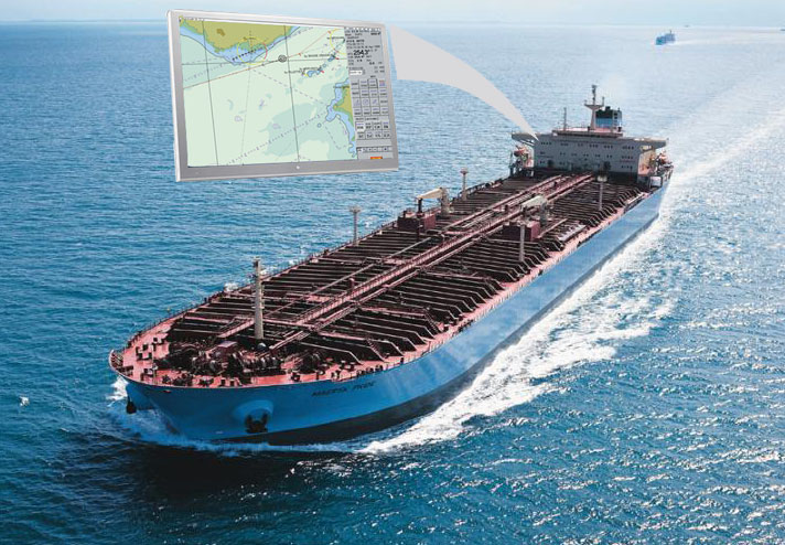
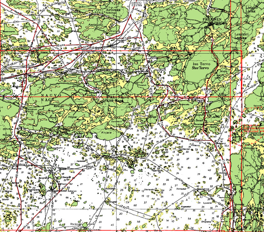
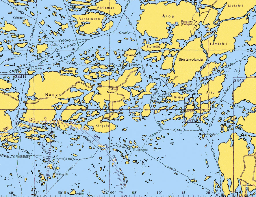
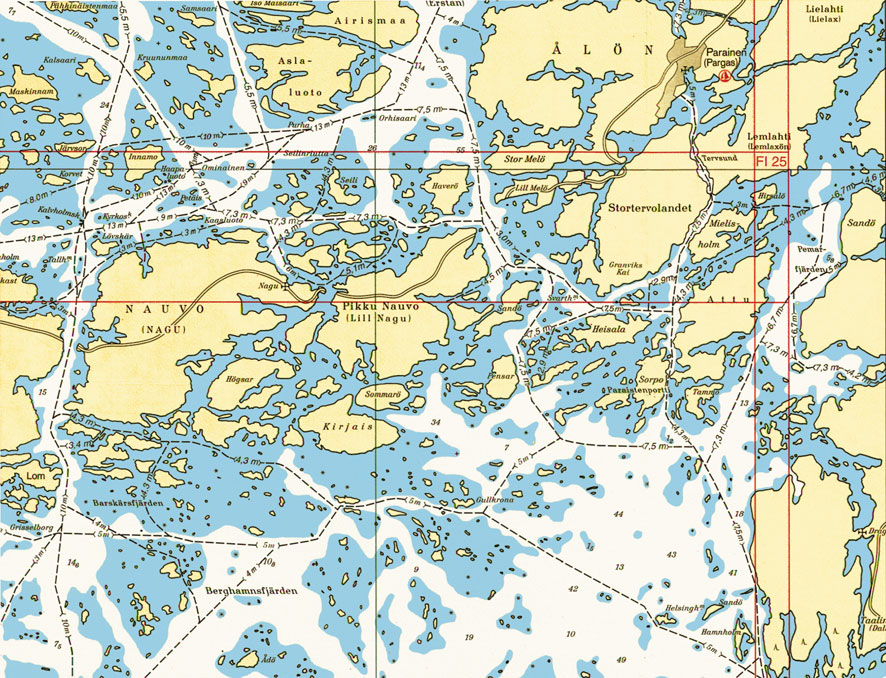
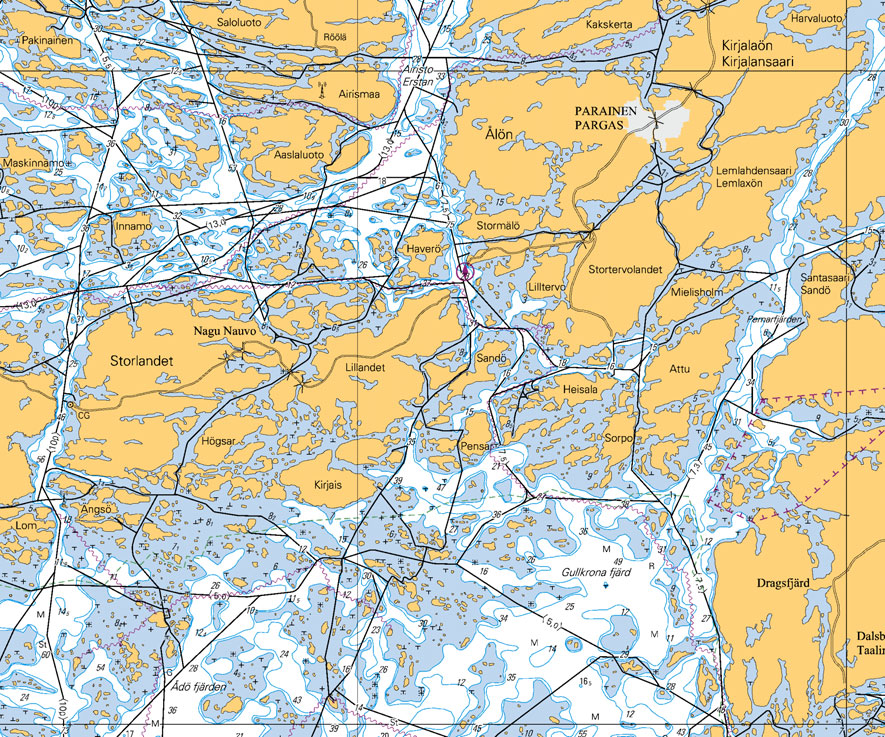
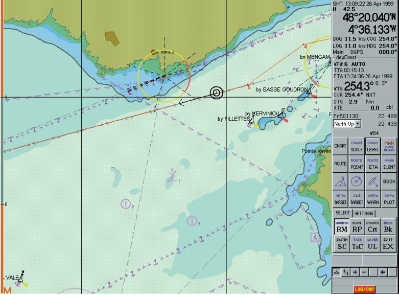
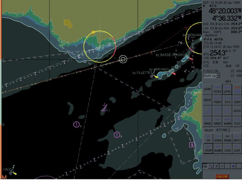
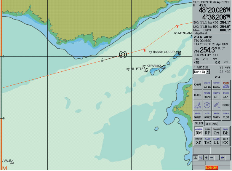
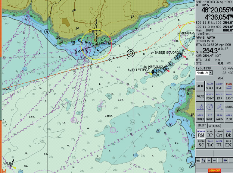
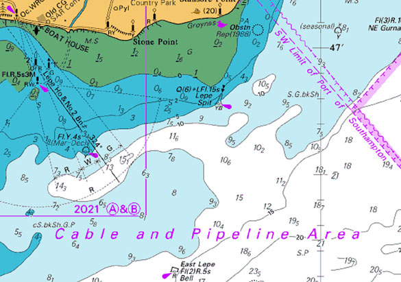
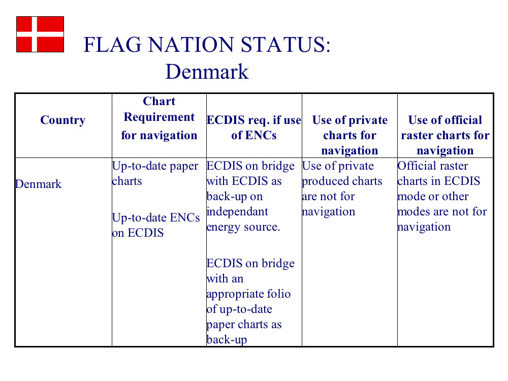
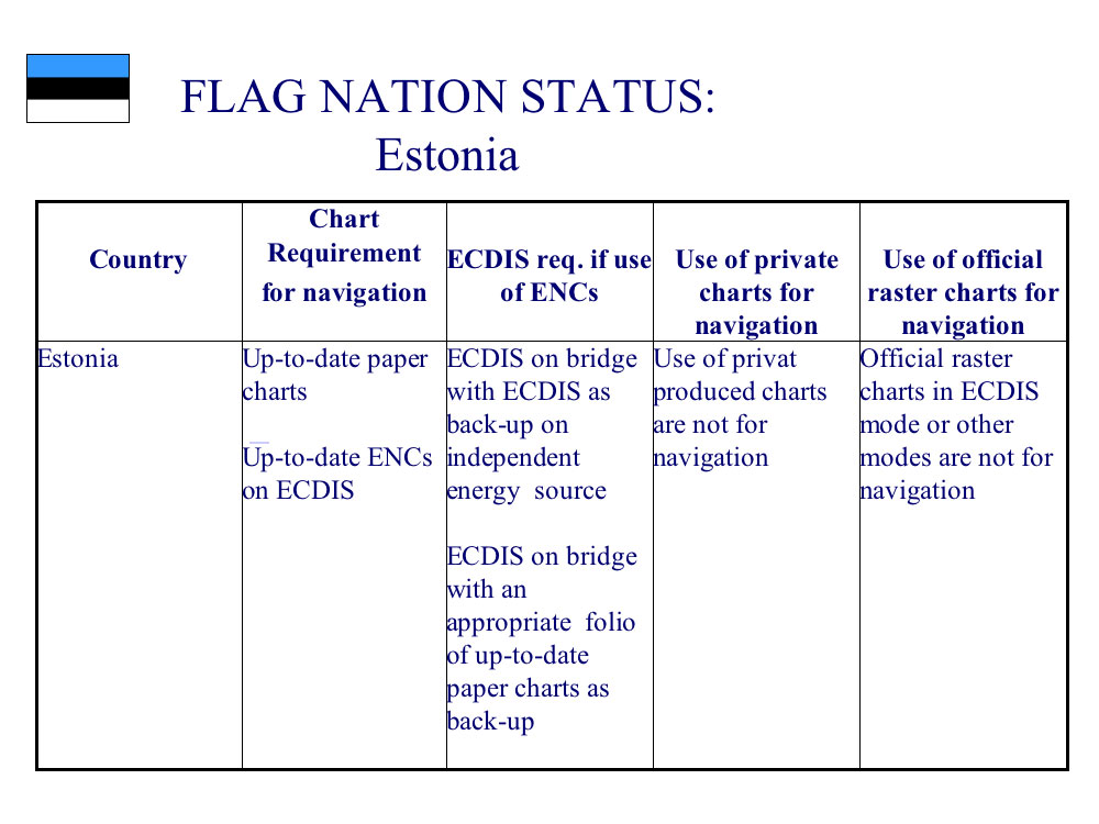
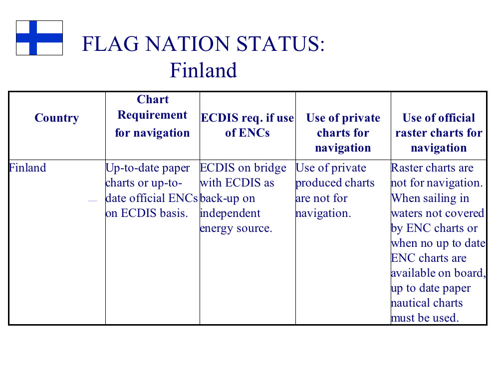
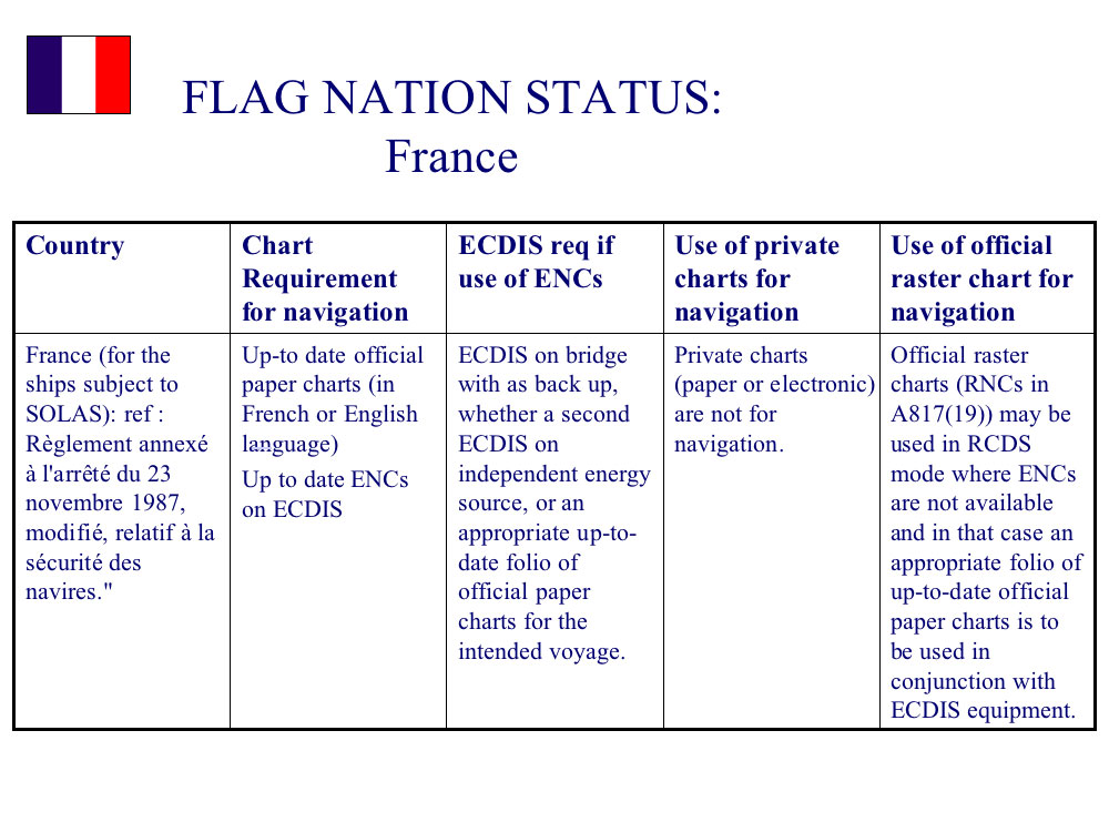
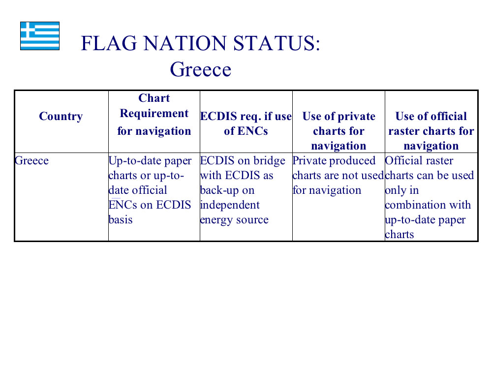
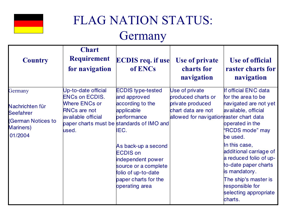
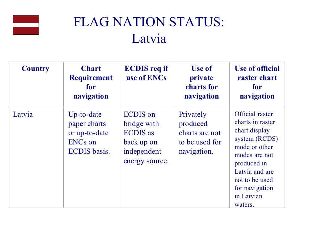
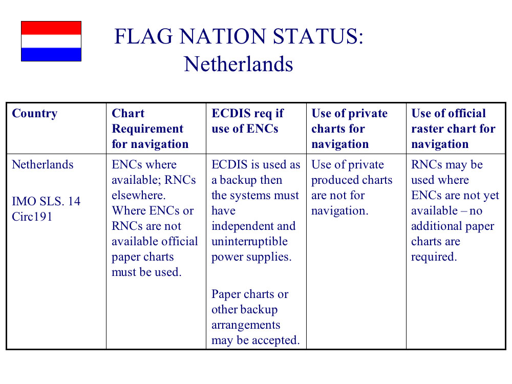
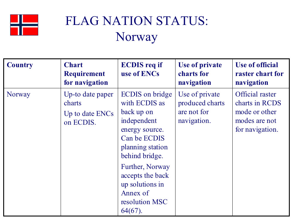
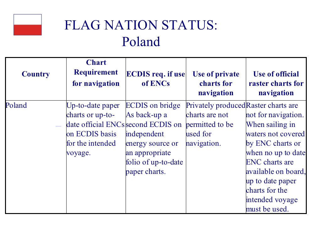
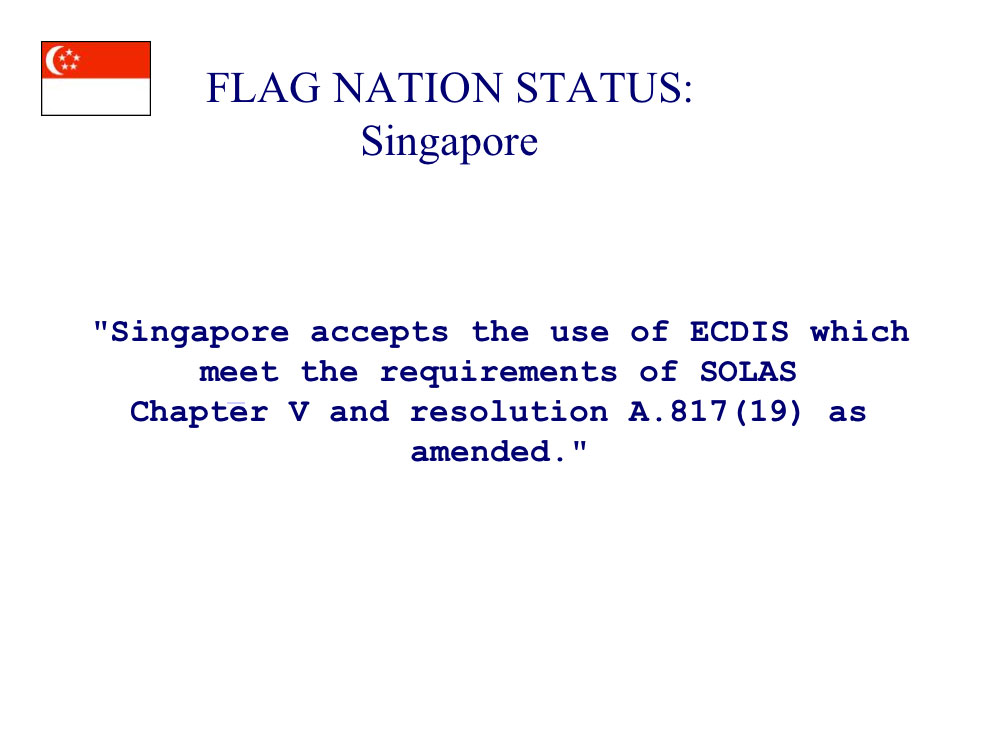
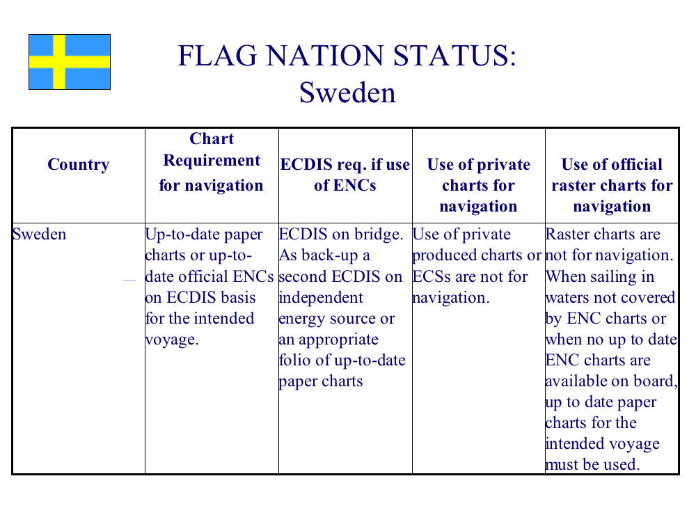
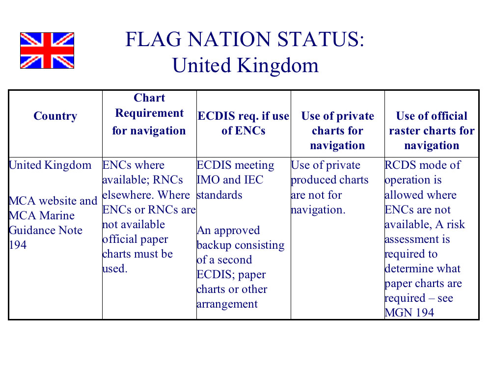
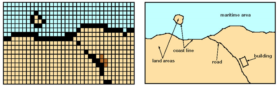
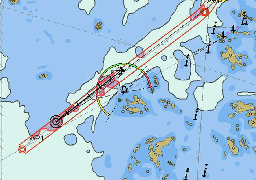
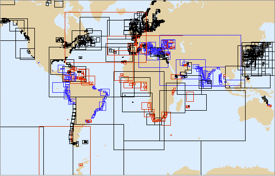
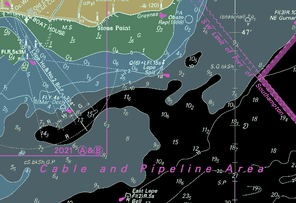


Kõik kommentaarid