Vajad kellegagi rääkida?
Küsi julgelt abi LasteAbi
Logi sisse

ECDIS Voyage planning (0)

1 Hindamata
Punktid

Voyage   Planning
Voyage Planning
The key  elements  of the Voyage Plan are:
 Appraising all  relevant  information
 Planning the intended voyage
  Executing  the plan taking  account  of prevailing 
conditions
 Monitoring the  vessel ’s progress against the 
plan continuously
Planning
 The detailed voyage or  passage  plan should 
include  the  following  factors:
1) the plotting of the intended route or  track  of the 
voyage or passage on appropriate  scale  charts: 
the true direction of the planned route or track 
should be indicated, as well as all  areas  of 
danger , existing ships' routeing and reporting 
systems, vessel traffic  services , and any areas 
where  marine  environmental  protection  
considerations  apply ;
2) the main elements to ensure  safety  of life at sea, 
safety and efficiency of navigation, and 
protection of the marine environment  during  the 
intended voyage or passage;  such  elements 
should include, but not be limited to:
Planning
2.1)  safe   speedhaving  regard to the proximity of 
navigational  hazards  along the intended route or 
track, the manoeuvring  characteristics  of the 
vessel and its draught in relation to the  available  
water depth;
2.2)  necessary  speed alterations en route, e.g., 
where  there  may be limitations because of  night  
passage,  tidal  restrictions, or allowance for the 
increase  of draught due to squat and  heel  effect 
when turning;
2.3) minimum clearance  required  under the keel in 
critical areas with restricted water depth;
Planning
2.5)  course  alteration  points , taking into 
account the vessel's turning  circle  at the 
planned speed and any expected effect 
of tidal streams and currents;
2.7) use of ships' routeing and reporting 
systems and vessel traffic services;
2.8) considerations relating to the 
protection of the marine environment; 
Planning
 3) The  details  of the voyage or passage 
plan should be  clearly marked and 
recorded, as appropriate, on charts and 
in a voyage plan notebook or computer 
disk .
Monitoring
 The progress of the vessel in accordance 
with the voyage and passage plan should 
be closely and continuously monitored. 
Navi -Sailor  2400   ECDIS
 Route Planning
Creating route plan along 
Your voyage from point of 
departure to point of 
arrival up to 999 WP, also 
checking route plan for 
presence of Navigational 
danger under the way 
(safe depth, isolated 
danger, etc…). Obtaining 
route plan table with 
coordinates of each WP, 
distances & courses 
between  WP's  total  
distance of created route 
plan.
The Navi-Sailor 3000 ECDIS 
Route Plan table contains the 
following:
 Geographical data (coordinates, course, 
GC/RL…) 
 Schedule information (ETA, ETD,  Average  
speed…) 
 Route Plan calculations take into account 
relevant  weather  and current  information 
Other  useful capabilities of the 
Route Planning facility include:
 ' Check  Route' functionality,  both  online and 
after the planning 
 Upload route to GPS 
 Graphical on- screen  and tabular route plan 
editing 
 Equalising of data between Master and 
Slave   station (-s) 
  Print  out of Route Plan information 
Autopilot
 Navi-Sailor 3000 ECDIS provides a 
facility for  sailing in the Autopilot mode.
Route Monitoring
 Route monitoring is  permanent  mode 
running concurrently with other  operation  
modes, it produces most  important  
information for navigator  while  sailing.
Chart  corrections
 Chart updates
are  provided  using Notices to Mariners documentation 
within  the respective countries. Chart updates are  delivered  
to customers on-line on practically the  same  day as the 
information is  released  on that country's HO web site. Chart 
Update  information for  Transas  charts in TX-97  format  is 
updated via the  Internet  every two weeks and is readily 
available for all  users  of the company's electronic chart 
systems.
 Distribution system
The professional distribution system used by the company, 
also enables customers to update the chart collection data 
whilst at sea, using specially  developed  CD ROMs, issued 
quarterly. Chart updates for TX-97 charts can also be 
received  on  floppy  disk or downloaded on-line, using 
Inmarsat Satellite Connections and/or via a  telephone  line 
during port  call .
Manual update 
 "professional" level ( colors
  user 's charts (colors) 
Integrated Navtex information
 The Transas Navtex  Manager  facility is capable 
of:
  Automatic   reading of messages arriving via 
NAVTEX and their processing; 
 Extracting co-ordinates, area, transmitting 
station, topic and other parameters; 
  Saving NAVTEX messages onto the  hard disk 
and displaying the  message  mark on the 
electronic chart; 
 Generating automatic alarms upon the  entry  in 
the area of note, received from the NAVTEX, or 
at the  approach  to a  single  message mark. 
Navtex Manager
 Navtex Manager is an  application   based  on a 
link  between the Navi-Sailor and the Navtex 
Receiver.
 Main  functions
 1.  Constant  automatic  reception  of NAVTEX 
messages.
 2.Automatic generation of NAVTEX message 
database and  storage  of the data.
 3. Automatic extraction of latitude/longitude 
position  from a Navtex message and its 
plotting on an electronic chart using  special  
symbols .
 4. Viewing and maintaining of the messages 
database and preparing data for Navi-Sailor 
products  processing.
 Implementation of all  these  functions can be 
obtained using any standard Navtex Receiver 
which has output to a parallel  printer
Alternatively, the Navtex Manager’s functions 
may be achieved with the use of Transas 
dedicated Navtex Receiver hardware.
Admiralty ECDIS  Service  
 Admiralty ECDIS Service combines the 
most accurate  official   vector  and official 
raster  electronic charts available to 
deliver   global  electronic chart coverage 
in a single, easy to  manage  package.
 The Admiralty ECDIS Service provides 
ENCs where available and ARCS charts 
where not. This IMO-approved 
combination enables shipping 
companies  to reap the benefits of ENCs 
while coverage is stil  growing, and helps 
to make the most of investment in 
Electronic Chart  Display  and Information 
Systems (ECDIS). 
As new ENCs become available, they 
are automatical y issued to Admiralty 
ECDIS Service customers, replacing 
their corresponding ARCS charts.
Frequency of Updates
 The Admiralty ECDIS Service only 
includes official electronic charts that fully 
satisfy IMO product specifications and are 
sourced directly from national 
hydrographic offices. 
Both ENCs and ARCS charts are 
continuously updated via the Admiralty 
weekly update service. All updates are 
provided on CD, and users will shortly be 
able  to download  them  via  email  and 
online using  website : www.ukho.gov.uk. 
Every week, updates include al  Notices 
to Mariners, New Editions, Replacement. 
Sensors
  Positioning  
 Gyrocompass 
     Primary  positioning 
 Magnetic  compass  
    Secondary positioning 
interface  
  ARPA  interface (Input/ 
 Speed Log 
Output) 
 Wind interface 
 ARPA (2nd ARPA) 
 Drift calculation 
interface 
 Temperature 
 Echo sounder interface 
 UAIS transponder interface 
 Output 
 Navtex Manager 
    navigational data 
  Radar  Integrator  Board  
    autopilot data 
    current course segment 
transmission 
Navigation databases
 Tides and tidal currents 
 Seasonal currents 
 Weather forecast chart overlay 
Potential Errors in Marine Navigation
    On a number of occasions chart data, particularly in canals, 
locks, harbours, ports and alongside wharves could not 
withstand the resolution of the ECDIS ‘zooming’  function . In 
many instances, the  result  has been that the  ship ’s  image  on an 
ECDIS display is depicted as overlapping the dock or jetty. 
There are many contributing factors  that may suggest that the 
ship’s image on the ECDIS screen is portrayed where ‘it does 
not belong’. These are due to GPS errors; DGPS errors; ECDIS 
errors; Installation errors; ENC conversion errors; chart 
errors; and hydrographic survey errors. There is also the factor 
of human­induced error. 
Risk of under­ or overinterpretation
 Errors may result in the conversion  process  when 
data from an ENC is used by the manufacturer of an 
ECDIS system. Whenever data is converted from one 
form to another, there is the risk of under­ or 
overinterpretation.  However , standards have been 
established  in S­57  Edition  3 and other IMO and IHO 
specifications. A common source of error exists in the 
underlying data from which the ENC is derived.  Such  
errors are a result of the ‘inappropriate’ scaling of the 
chart data caused by: survey errors; horizontal  datum  
errors and uncertainties; unreported  changes ; and 
obsolescent survey  technology
Alarms 
 Antigrounding 
 Sensors 
 Route 
  Network  
 Radar/Targets (CPA/TCPA) 
 Chart areas 
 Others 
Logging functions
 Track, Logbook 
 Targets data 
 Radar overlay 
 Logbook, Route, Screen shots printout 
 Playback 
Testing  ECDIS 
 The International Electrotechnical Commission 
(IEC) has identified and described the 
necessary  performance   tests  and checks for an 
IMO-compliant ECDIS. IEC Publication 61174 
is the  basis  for type- approval  specifications 
related  to operational methods of testing and 
required test  results  for an IMO-compliant 
ECDIS. IEC 61174 is used as the basis for 
type-approval/certification by Maritime  Safety 
Administrations for an IMO-compliant ECDIS.
    ECDIS must comply with  five   types  of standards :
 As an onboard electronic  equipment   included  in  SOLAS  
convention , ECDIS must comply with IMO standards 
(Resolution A817 (19) and its amendments MSC.64(67) & 
MSC.86(70)),
 As a navigational chart display system, ECDIS must comply 
with the specifications for chart content and display issued 
by IHO (publications S-57 et S52),
 As an electronic equipment, ECDIS must comply with 
requirements  published by IEC (IEC publication 61174, 
Committee  80-WG 7),
 Using telecommunications, ECDIS  comes  under the 
prescriptions of the CIRM,
 As an onboard equipment, ECDIS comes under the 
procedures of type approval performance defined by national 
authorities.
ECDIS backup  arrangements
 ENCs can be used for primary navigation in  place  of 
paper  charts, provided there is a suitable backup (e.g. 
another ECDIS with a separate power  supply , or an 
appropriate folio of up to  date  paper charts**).

 ** What is  considered  'an appropriate folio of up to date 
paper charts' wil   vary  between flag  states , and may or may 
not  represent  a reduction in the number of paper charts 
required to be carried.
Risk of Overreliance
 ECDIS is an effective tool for 
 However, the  mariner  needs to have 
safe navigation, provides real­
total  confidence  in the capability 
time information for the mariner 
and limitations of the equipment. 
and will inevitable be universally 
Such a system must not lull the 
adopted. 
mariner into a false sense of 
 It is a sophisticated  object  
security . Mariners must ensure that 
database that maintains the 
they do not depend  solely  on one 
mariner’s navigations objects 
system without some  means  of 
such as waypoints, routes, and 
occasional cross­referencing or 
specific  points of  interest  and 
verification . Audible and visual 
provides very  good  security for 
alarms must be heeded. The system 
the user’s navigation data 
must not be  seen  as a substitute for 
the observance of good seamanship 
nor for neglect of an effective 
watchkeeping throughout a voyage. 
                                

Document Outline

  • Voyage Planning
  • Slide 2
  • Planning
  • Slide 4
  • Slide 5
  • Slide 6
  • Monitoring
  • Navi-Sailor 2400 ECDIS
  • The Navi-Sailor 3000 ECDIS Route Plan table contains the following:
  • Other useful capabilities of the Route Planning facility include:
  • Autopilot
  • Route Monitoring
  • Chart corrections
  • PowerPoint Presentation
  • Manual update
  • Integrated Navtex information
  • Slide 17
  • Navtex Manager
  • Admiralty ECDIS Service
  • Frequency of Updates
  • Sensors
  • Navigation databases
  • Potential Errors in Marine Navigation
  • Risk of under- or overinterpretation
  • Alarms
  • Logging functions
  • Testing ECDIS
  • Slide 28
  • ECDIS backup arrangements
  • Risk of Overreliance
  • Slide 31
Vasakule Paremale
ECDIS Voyage planning #1 ECDIS Voyage planning #2 ECDIS Voyage planning #3 ECDIS Voyage planning #4 ECDIS Voyage planning #5 ECDIS Voyage planning #6 ECDIS Voyage planning #7 ECDIS Voyage planning #8 ECDIS Voyage planning #9 ECDIS Voyage planning #10 ECDIS Voyage planning #11 ECDIS Voyage planning #12 ECDIS Voyage planning #13 ECDIS Voyage planning #14 ECDIS Voyage planning #15 ECDIS Voyage planning #16 ECDIS Voyage planning #17 ECDIS Voyage planning #18 ECDIS Voyage planning #19 ECDIS Voyage planning #20 ECDIS Voyage planning #21 ECDIS Voyage planning #22 ECDIS Voyage planning #23 ECDIS Voyage planning #24 ECDIS Voyage planning #25 ECDIS Voyage planning #26 ECDIS Voyage planning #27 ECDIS Voyage planning #28 ECDIS Voyage planning #29 ECDIS Voyage planning #30 ECDIS Voyage planning #31
Punktid 50 punkti Autor soovib selle materjali allalaadimise eest saada 50 punkti.
Leheküljed ~ 31 lehte Lehekülgede arv dokumendis
Aeg2015-01-23 Kuupäev, millal dokument üles laeti
Allalaadimisi 7 laadimist Kokku alla laetud
Kommentaarid 0 arvamust Teiste kasutajate poolt lisatud kommentaarid
Autor rivomate Õppematerjali autor
Ecdise teekonna planeerimine
Inglise keeles

Sarnased õppematerjalid

Optional use of ECDIS
120
pdf

Optional use of ECDIS

. . . .10 Where can I get official ENCs? . . . . . . . . . . . . . . . . . . . . . . . . . . . . . . . . . . . . . . . . . .10 How are official ENCs protected? . . . . . . . . . . . . . . . . . . . . . . . . . . . . . . . . . . . . . . . .11 What is an official RNC? . . . . . . . . . . . . . . . . . . . . . . . . . . . . . . . . . . . . . . . . . . . . . . . .11 How are charts kept up-to-date? . . . . . . . . . . . . . . . . . . . . . . . . . . . . . . . . . . . . . . . . .12 What is ECDIS? . . . . . . . . . . . . . . . . . . . . . . . . . . . . . . . . . . . . . . . . . . . . . . . . . . . . . . .13 How is an ECDIS approved and by whom? . . . . . . . . . . . . . . . . . . . . . . . . . . . . . . . .14 Meeting Carriage Requirements with ECDIS . . . . . . . . . . . . . . . . . . . . . . . . . . . . . . .14 What to do in areas without official ENC coverage? . . . . . . . . . . . . . . . . . . . . . . . . .16 What are the requirements for the safe use of ECDIS ? . . . . . .

Merendus
Merepraktika aruanne-Praktikakoht Victoria I
78
pdf

Merepraktika aruanne: Praktikakoht Victoria I

....................................................67 Integreeritud sild ........................................................................................................................67 Manta Radar ..............................................................................................................................69 Radari menüü .............................................................................................................................70 Manta 3 ECDIS .........................................................................................................................72 NIS 2002 MkII AIS ...................................................................................................................73 MX420 series GPS/DGPS navigator .........................................................................................74 SEM200 track Keeping Autopilot ............................................................................

Merepraktika
General terms SMCP
20
pdf

General terms SMCP

Derelict Vessel still afloat, abandoned at sea Mahajäetud laev Mahajäetud laev, veel ujuvil Destination Port for which a vessel is bound Sihtsadam Sadam, kuhu laev suundub Disabled A vessel damaged or impaired in such a manner Vigastatud Laev, mis on vigastatud või as to be incapable of proceeding on its voyage (avariiseisundis) laev kahjustatud sellisel viisil, et ta ei suuda jätkata merereisi Disembark (to) To go from a vessel Laevalt lahkuma Lahkuma laeva pardalt Distress alert (GMDSS) A radio signal from a distressed vessel Hädahäire (GMDSS) Raadiosignaal merehädas

inglise teaduskeel
Tarkvara kokkuvõte inglise keeles
36
doc

Tarkvara kokkuvõte inglise keeles

feedback from the state of the system after implementing changes. Feedback from the customer: The functional tests (aka acceptance tests) are written by the customer and the testers. They will get concrete feedback about the current state of their system. This review is planned once in every two or three weeks so the customer can easily steer the development. Feedback from the team: When customers come up with new requirements in the planning game the team directly gives an estimation of the time that it will take to implement. Feedback is closely related to communication and simplicity. Flaws in the system are easily communicated by writing a unit test that proves a certain piece of code will break. The direct feedback from the system tells programmers to recode this part. A customer is able to test the system periodically according to the functional requirements (aka user stories)

Tehnoloogia
CPM1A Programmable Controllers Operation Manual 1784470
402
pdf

CPM1A Programmable Controllers Operation Manual 1784470

Cat. No. W317-E1-11 SYSMAC CPM1A Programmable Controllers OPERATION MANUAL CPM1A Programmable Controllers Operation Manual Revised October 2007 iv Notice: OMRON products are manufactured for use according to proper procedures by a qualified operator and only for the purposes described in this manual. The following conventions are used to indicate and classify precautions in this manual. Always heed the information provided with them. Failure to heed precautions can result in injury to people or dam- age to property. ! DANGER Indicates an imminently hazardous situation which, if not avoided, will result in death or serious injury. Additionally, there may be severe property damage. ! WARNING Indicates a potentially hazardous situation which, if not avoided, could result in death or serious inju

Automatiseerimistehnika
Projekt
11
pdf

Projekt

Tallinna Tehnikaülikool Raadio- ja sidetehnika instituut Projekt ainetes ,,IRT0030 Andmeside" ja ,,IRT0100 Kommunikatsioonivõrkude struktuurid ja teenused" teemal «VoIP teenus» Üliõpilane: Ruslan Karpovits Õpperühm: IATM Matrikli nr: 050829 Õppejõud: Avo Ots Tallinn 2008 Author's word This project is written to show some interesting aspects of working with VoIP (Voice over Internet Protocol) service. The project briefly describes the process of finding a solution for based VoIP problem and its realization.

Andmeside
Merekaardil kasutatavad sümbolid
5
docx

Merekaardil kasutatavad sümbolid

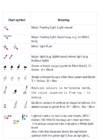
Chart symbol Meaning Major floating light: Light vessel Major floating light: Superbuoy, e.g. an ODAS buoy Minor light float Major light (e.g. lighthouse); minor light (e.g. harbour light) Green or black buoys (symbols filled black): G = Green ; B = Black Single coloured buoys other than green and black: Y = Yellow ; R = Red Multiple colours in horizontal bands, the colour sequence is from top ↓ to bottom Multiple colours in vertical or diagonal stripes, the darker colour is given first. W = White ; Bu = Blue Lighted marks on multicoloured charts, GPS / Galileo / GLONASS displays and chart plotters. The yellow coloured lobe indicates a White light here! Als

Kategoriseerimata
Introduction of SCM
40
doc

Introduction of SCM

loop. However, supply chain management can be a very difficult task because in the reality, the supply chain is a complex and dynamic network of facilities and organizations with different, conflicting objectives. Supply chains exist in both service and manufacturing organizations, although the complexity of the chain may vary greatly from industry to industry and firm to firm. Unlike commercial manufacturing supplies, services such as clinical supplies planning are very dynamic and can often have last minute changes. Availability of patient kit when patient arrives at investigator site is very important for clinical trial success. This results in overproduction of drug products to take care of last minute change in demand. R&D manufacturing is very expensive and overproduction of patient kits adds significant cost to the total cost of clinical trials. An integrated supply chain can reduce the

Kategoriseerimata


Meedia

Kommentaarid (0)

Kommentaarid sellele materjalile puuduvad. Ole esimene ja kommenteeri


Sellel veebilehel kasutatakse küpsiseid. Kasutamist jätkates nõustute küpsiste ja veebilehe üldtingimustega Nõustun