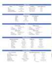
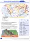
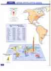
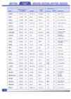
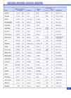
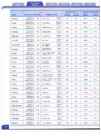
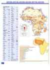
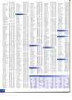
Malestrom Major Rivers N am e Continent Out fl o w T o tal Lengt h (mi.) Nile Africa Mediterran ean Sea 4,1 60 Am azo n South Am erica Atlantic Oce an 4,000 Ch ang (Yangtze) Asia East China Sea 3,964 M ississippi-M iss o u ri N o rt h Am eri ca Gul f of Mexico 3,710
Major Deserts Name Continent Area (sq. m i.) Sa hara Africa 3,500 ,000 Gobi Asia 500,000 Libya n Africa 450,000 Sono ran No rt h Ameri ca 120,000
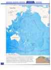
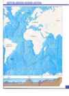
Oceans Arct ic Ocean Atlantic Ocean Area: 5,426 ,000 sq. mi . Area: 3 1,73 6,000 sq . mi . Coastline: 28 ,209 mi . Coastl ine: 69 ,525 m i. Average De p t h: 3,407 ft. Average De p t h: 11,730 ft. Indian Ocean Pacific Ocean Area: 28,410,000 sq. mi . Area: 63,838,00 0 sq. m i. Coas tli ne: 4 1,346 m i. Coas tl ine : 84,315 m i. Average Depth: 12,598 ft Average De p th: 12,925 ft.
Highest Elevations M o untain Peak Name Place Height (ft.) Con tinen t Kilimanja ro Tanzani a 19,340 Africa Vinson Massif Antarctica 16,864 An tarctica Everest Nepal - Tibet 29,035 Asia Kosciu sk o Australia 7,3 10 Au stral ia Elb rus Russia 18,5 10 Europe Mc Kin ley Alask a, U.S. 20,320 N orth Am erica Aconcagua Argentina 22 ,834 South America
Lowest Elevations
Lo west P o in t Name Place Dep th Below Sea Lev el (ft .) Continen t Lake AssaI Djib outi 512 Afri ca Bentl ey Subgla cial T re nc h Antarctica 8,327* Antarctica Dead Sea Israel-Jo rdan 1,3 10 Asia Lak e Eyre Aust ralia 52 Aus trali a Cas p ia n Sea Rus sia - Azerbaijan 92 Europe Death Valley Califo rn ia, U.S. 282 North America Vald es Pen in su la Argentina 13 1 South America ' Estimated
Copynght © 2005
by MapQue st. Inc
All rig~ t s reserved - World Facts and Figures Inside front cover Using This Atlas .4- 5
Legend 6
Map Scale 7
Latitude and Longitude 8- 9
Different Kinds of Maps 10-11
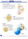
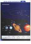
Our Solar System 12- 13
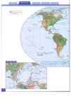
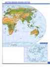
World Physical 14- 15
World Political 16- 17
Ocean Floor 18- 19
Dynamic Earth
Earthquakes 20
Volcanoes 21
Continental Drift 22-23
Published by World Climate 24-25
World Vegetation 26- 27
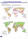
World Environment
Copynght © 2005
World Forest Cover 28
by Meprxest. Inc.
All nqhts reserved.
Tropical Ra in Forests 29
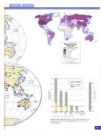
World Population
While everycare has been taken to trace and acknowledge copy Population Density 30-3 1
right, the publishers tender their apologies for any accidental infringement where copynqht hasproved untraceable. Population Projections 30
Allnghts reserved. No part of thrs book may be reproduced or trans World Population
mitt ed In any fo rm by any means electronic, mechanical , or other Wise , whether now or hereafter devised. including photocopying, Life Expectancy: 1999, 2025 32
recording, or by any Information and retrieval system, without espress writt en prio r pe rm ission from the Publisher . Youthful Population 33
Acknowledgements. Food and Nutrition 33
"How to use this Atlas" written by ElspethLeacock
World Culture
MeXICO Statecoat of arms on page 76. © 200J mextcan- Ilaq .com Languages 34
Photographs on pages 24-25 (Deserts, Nature , China/Tibet. Alaska ,
Brazu, Arctic ). 26-27 ( Landscapes . Nature, Australia, China/ Tibet), 59 Literacy 34
(rivers), 60--61(nature, Landscapes, Hawaii , Caribbean ), 62- 63 (Arctic)
Copynqbt © 2005 Corel corp . and their suppliers. Religions 35
Photographs on pages 26-2 7 1V01.16, 44, 74), 60- 61 1V01. 16, 44). Historical Spread of Religions 35
62-3 1V01. 16, 44)
Copyright © 2005 Pbotolxsc. Inc. World Land Use , 36- 37
Photograph on page 42 (Wright brother's flight ) Copynght © 2005 NASA Industrial Employment 36
Photographs on pages 58, 62- 63 ( Southern California ) Agricultural ,Employment 37
Ccpynqbt © 2005 Drqital Stock Corp. World Resources
Photograph on page 62 (Rockiespring) Copynghl © 2005 Freestockphotos ccm Oil, Natural Gas, and Coal 38-39
Pnotcqraphs on pages 68--69 No!. 194 ) Major Minerals 38-39
Copynqbr © 2005 Corbrs Corp. Electrical Energy Production 39
World Communications
Television Receivers .40
Newspaper Circulation .41
Personal Computers .41
Cellular Communications .41
World Transportation
Time Zones .42
Major Airports .43
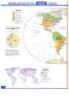
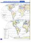
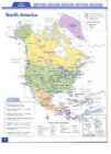
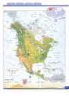
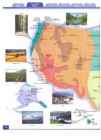
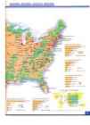
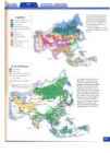
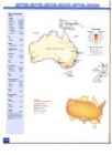
North America Political .44 South America Themes , continued
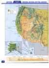
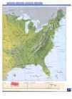
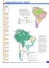
North America Physica l .45 Environmental Issues : Deforestation , Desertification 83
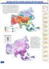
North America Themes Europe Political 84
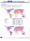
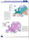
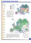
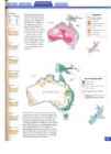
Population Density .46 Europe Physical 85
Gross Domestic Product (GDP) .47 Europe Themes
Land Use 47 Population Density 86
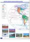
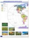
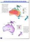
Climate .48 Gross Domestic Product (GDP) 87
Precipitation .48 Land Use 87
Vegetat ion .49 Climate 88
Environmental Issues: Deforestation, Desertification, Precipitation 88
Acid Rain .49 Vegetat ion 89
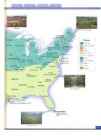
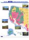
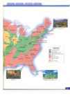
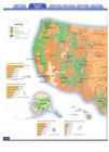
Un ited States Political 50-51 Environmental Issues: Deforestat ion, Desertification,
United States Political Facts 52-53 Acid Rain 89
Un ited State s Physical 54-55 Africa Political 90
Un ited States Physical Facts 56-57 Africa Physical 91
Geographic Featu res Africa Themes
Continental Divide 58 Population Density 92
U.S. Earthquakes 58 Gross Domestic Product (GDP) 93
Fall Line 59 Land Use 93
Faults 59 Climate 94
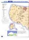
United States Cli mate 60-61 Precipitation 94
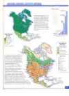
United States Vegetation 62-63 Vegetation 95
United States Land Use 64-65 Environmental Issues: Deforestation, Desertification 95
United State s Resources 66-67 Asia Political 96
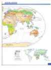
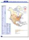
United State s Transportation: Road , Ra ilroads, Airports . .68-69 Asia Physical 97
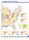
United States Population Asia Themes
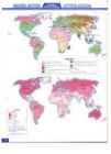
Population Density 70-71 Population Density 98
Distribution of Population by Region : 1900, 1950,2000 70 Gross Domestic Product (GDPr 99
Center of Population 71 Land Use 99
Percent Change in State Population, 1990-2000 .71 Climate 100
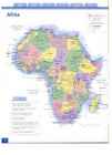
United States Economy Precipitation 100
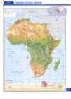
Per Capita Income 72.-73 Veqetatio n> 101
-, Persons Below the Poverty Level .73 Environmental Issues: Deforestat ion, Desertification,
Canada Political 74 Acid Ra in ; 101
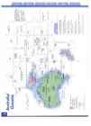
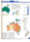
Canada Physical .75 Australia and. Oceania Political ...r" 102
Mexico Political 76 Australia and Oceania Physical 103
Mexico Physical 77 Australia and-Oceania Themes
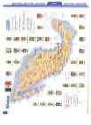
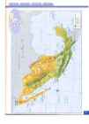
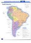
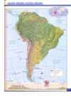
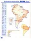
South America Political .78 Population Density 104
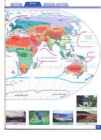
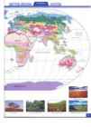
South America Physical 79 Gross Domestic Product (GDP) 105
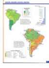
South America Themes Land Use 105
Population Density 80 Climate 106
Gross Domestic Product (GDP) 81 Precipitation 106
Land Use 81 Vegetation 107
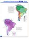
Climate 82 Envi ronmental Issues: Deforestation , Desertification 107
Precipitation 82 Index 108- 112
Vegetat ion 83 Geographic Glossary Inside back cover ·
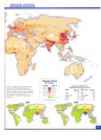
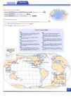
is a collectio n of Finding Di rection AN ATLAS m ap s that can be us ed to find information abo ut your world. The To find directi ons use th e m ap's compass rose. You can also lise lines oflati tude an d longi tude very latest data has been collected to mak e these maps. Hundred s of sat ellite im ages were used to map th e dramatic sh rin king of Eart h 's for est s. -w 4 5 E to find directio n . Every line oflongi tude points n orth a nd so uth. Every lin e oflati tud e points east and west. You can learn m ore abo u t la titude The latest cens us data from each a nd every coun and longitud e on pages 8-9. tr y was used to build a picture of Eart h's current population. T he m ost recent scienti fic research Readin g Map Symbols was used to crea te th em atic map s of continental Every m ap sym bo l shows the locati o n of some drift, th e ocea n floor, th e envi ro nme n t and our thing . It could be so m ething as large as a conti natural resources. Look closely an d yo u will see nent o r as sm all as a bird -house. A dot that th e informat ion fo r th e map s comes from sh ows th e locat ion of a city. A blu e line many di fferent so urces suc h as NASA, th e U.S. shows the co urse of a river . Bu t map Department of th e Inter ior or th e Wo rld Bank . sym bols are not t he same on all maps. You can use th ese map s to explo re yo u r world, One map m ight sho w a city with a discover co n nec tions bet ween places , and see sq uare. Map legends or keys help relation ships between places a nd peoples . explain t he symbols used on a map. But thi s a tlas is m o re than ju st a wealth of You ca n find o ut m o re abou t legends information . It is fun to look a t to o. You will an d th e m a p sym bo ls used in this atlas find th at th ese ma ps an d ph o to graphs can evo ke on page 6. im ages of far away pla ces. T hey in vite you to pause an d to dream . With a m ap you can journey th e world without ever getting wet, cold , tir ed or Special Features o f this Atlas hungry. You ca n im agine grea t adven tu res an d not leave th e co m fort of your favorite ch air! Th is atl as has been designed and organi zed to be easy fo r you to use. Here is a "ro ad map" to your To get th e most o ut of this a tlas you need to atlas . know how to read maps. Just as you learned to read wo rds like th e o nes on thi s page, you can The Blu e T ab Ba r learn how to read th e lan guage of maps. The So mewhere along the top blue tab ba r of each map skills yo u need to kn ow ar e: sp read yo u will see a dark er blu e tab . It tells you 1. locating pla ces 2. measuring di stance 3. finding directi on 4. read ing m ap sym bols
Locating Places To find pla ces in thi s a tlas, you can begin with th e subject of th e map or ma ps you are look in g th e index. To find Dalla s follow th ese steps . at. The ligh t blue ta bs tell you the subjects of the
CUlCO, Peru 78 13'3 2'5 71'S6'W 1. Look up Dallas in th e index a t th e sur ro un ding m ap spreads. If, for example, you
Cyclades, Islands 85 37'OO'N 2S'OO'E
Cyprus, country , 96 3S'OO'N 33' OO'E en d of thi s book. are loo king at the World Clim ate map and would
Cyprus, Island 97 3S'OO'N 33'OO'E
Cyrenaica,region 91 2S'OO'N 24'OO'E 2. T he index tells you th at D alla s is a lik e to co mpare it to th e World Vegeta tio n m ap, Czech Reo.. country 84 49'OO'N lS'OO'E city in Texas and that it can be you can use the tabs to find that map q uickly found on page 50. You will also and easily.
Dakar, Senega! 90 14' 42'N 17'27'W learn that Dallas is located at
Dallas, TX 50 32' 47' N 96' 48'W
Dalmatia, region
Dernareland, region 85 91 44' 00'N 16'0 0'E 21'00'5 19'OO'E
32 °4 7'N (32 de gr ees 47 minutes Map Skills
Damascus, SYria
d'Ambre, Cap, cape 96 91 3J'J l' N 36' 18'E 12' 00'5 48'0 0'E
north) and 96° 48' W (96 degr ees 48 Look at t he blu e tab bar above and you will see
Da Nang, Vietnam Danube , nver 96 85 16' OJ'N 108' 12'E 49' OO'N 10' OO'E
minutes wesr.) that you a re in t he m a p skills sectio n. This sec
DanubeDelta, delta Derdeoel'es.st-e« 85 85 4S' OO'N 29'OO'E
40'OO'N 27'OO'E 3. Go to page 50 and find th e lin e of tion should be called "Read Me First " beca use it
Dares Salaam , Tanzania
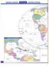
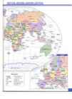
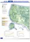
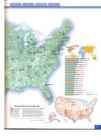
Darling, fiver 90 103 6'49 '5 39' 17'E Jl 'OO'S 144'00' E latitude nearest to th e number is here that you will fin d all sorts of helpful 32 ° N and th e lin e oflongitude inform a tio n about maps and how to read them . nea rest to th e number 96 °W. You will find Even if yo u are a p racticed m ap reader, read t his Da llas close to wh ere th ose two lin es m eet. You sect ion ! can learn more ab out latitude a nd longitude o n pages 8- 9. The Wo rl d · reneda In th is section you will find a world poli tical Measuring Distance map, a wo rld physical m ap, an d 35 world the To m easure di stance most maps have a distan ce matic m aps. T he world political m ap shows the
o 200 400 mi scale. You can learn more abo u t m easuring di s most u p to date na tional boundaries. On the
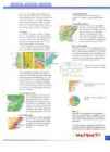
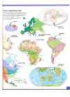
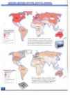
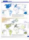
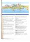
6 260 ' 400 km ' tan ce on pa ge 7. wo rld physical m ap yo u can see huge desert s, great moun tai n ran ges, a n d even th e sea ice Canada and Mexico that covers much of th e Arcti c. The th ematic Ca n ada and Mexico b oth h ave t h eir own maps inclu d e t he most up to date mforrnanon spread s that include a political and phys ical on everything from the world di stribunon of m ap. com p u ters and televisions to life expectancy, religion an d literacy. If you want to see the Geographic Features ocean floo r, o r to find wh er e 111 the world vol Th ere are two sp ecial "Geogr ap hic canoes fo rm , th is IS the sec tio n to look in. Feature s" mcluded in this atl as. To find out how th e co n t ine n ts, Earth 's Co n tin en t s \1. greatest land features, have been The co ntin ent u n its are de sign ed to all have drifnng a ro u n d the glo be, turn to t h e same kin ds o f m ap s. This will en able yo u pages 22 -23 . To t ake an 1t1 de p th to compare and contrast one continenr with look at fall line s, d ivid es, and fau lts an o t he r with ease an d accuracy . There IS a turn to the United States Geograp h ic political map, a ph ysical map, and a to tal o f Features sp read o n pages 58 -59 . seven them ati c maps p er co n tinen t. Used individ u ally each map can provide Charts and Graphs answers to m any q u es tio n s. But all together , This atlas IS filled With ch arts, graphs an d d ia each set of m aps can be used to tell a story. grams. They are used to gIve m ore information
Fi e!
.\ N Van c o~ ~~;~; : ._ 1 * 0" about su bject s shown on th e maps. To make these charts and grap h s, long list s of th e m ost up to date data was gathered. Then al l th ose T"c~ " . · .( Portlafld. number s were o rganized into gr aphic d isp lays - ..."1:: th at ca n be read sim p ly and acc u ra tely. - - Consumpt ion
20 -----~
i; l 15 Line graphs are u sed to sh ow change in amounts over time. ] 10 f-- -:7"'S,£-- """"= '----.:::>---.-E. o Im agine a jo u rn ey cro ssmg a contin en t . You ~ 5 f'-----+-~"'----- can see t h e regio n s vrsi red , the rnounrams climbed, or t h e de serts crossed. You can tell if 1950 1960 1970 1980 1990 2000 many peo pl e are passed al ong the way o r few. You ca n d escr ib e th e acnvin cs of th e people. Will yo u see nun ers o r ranc he rs o r farmer s? IA $2.679 An d yo u can tell about the different climates NC $1 ,624 Bar gr aphs ar e used to co m exp erienced alon g th e way. All o f rhrs informa MN $1,083 pare amoun ts. tion an d m ore is on th e maps for every conn IL $762
nent but An tarct ica. NE $640
IN $545 Enviro n m en t al Issues T h ere IS a sp ecial "E nv ironmen tal Issu es" feature for each continent Pie chart s show percentages of an d o ne for the wo rld. To cr eate a total . th ese features the latest SCIen tific in fo rm a n o n wa s gath ered an d orga ni zed for yo u. The topiC S cover th e three major en vironmental Issues faced by crn zcn s today , desertific a tio n , d eforestati on, an d acid ram. Glossary Ther e are many geographic terms fo u n d on The United Sta t es maps such as fjord , isthmus, or plateau . Yo u can L.- oston In th e sectio n o n the Umred States find th e m eaning o f th ese and ot h er t erm s in NY t MA T 1 \ P you will find a pol itical map WIth tw o pag es o f poliucal fact s, a physi cal map With two pages o f physic al the geographic glossary located on t he in sid e back cover.
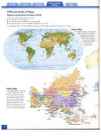
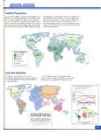
facts, an d seven themanc map The staffat Mapquest worked hard to make this atlas sp reads . a referencebook that is bothfull ofinformation and fun and ea.ry to use. We hopethaty ou enjoy your copy. T he fo llowi ng sym bo ls are used her e for gen eral referen ce m ap s. Map s Legend with spec ial su bjec ts (thematic m ap s) have their own ul1lqu e legends.
* General Reference Maps National capita l
Other capita l
D Nonsubject area Mou ntain peak Physical Maps Legend Pack ice --Ft3==~----::;?("---;;;;:r\l , .0 Ice caps Oth er city Lowest p oint M o unt ain s-+-----"~ International boundary = Perennial lake or: -7~~'"-:---t-- Tundra (pol iti cal map) Intermitt ent lake Internati onal bou ndary in Oceans and Perennial river seas --'=+~+-f-- Forests d ispute/und efined (polit ical map) Falls State or provincial boundary .~£-..:..~__;=.",.:r_---+- Grassl ands International boundary Arid lands - +--."".,.v (physical map) International boundary in d ispu te (physical map)
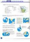
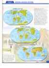
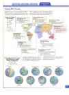
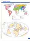
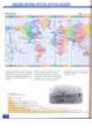
A glo be IS the m ost accu ra te picture of the Earth. Onl y a glo be ca n show di st an ce, directi on,
Projections an d the t ru e sha pe a nd area o fl and and sea. Map m akers st ruggle with how to sho w th e ro und world on a fla t map .
Mercator Projection Gerardus Merca tor, a Du tc h map ma ker, wanted a map proj ection th at sho wed directi on and shape accurately. T he prob lem s with drst o rr ron s are mo re ob vIOUS o n rlu s p rojecti on. Yo u can see th at the lan d ar eas a re very d istorted the clo ser to th e pol es th a t yo u ge t. So, thi s Imagine the Earth as projecti on ende d up grearly a large balloon. distorting d ist an ce a nd size . \ Cut it apart, and flatten it ~\ to make a map.
To show th e ro und Ear rh o n flat pap er , m apm ak ers used d ifferent
projections , o r ways o fjsho wm g a ro u n d sha pe o n a flat su rface .
Thisdiagram shows how a Mercator projection distortsthe
With every proj ection the sha pes o f places a re cha nged so m ewhat. sizes ofplaces. Compare
This IS ca lled di stortion . To find distorti on, you can co m pa re the Greenland on the map and the
la tit ud e and lon gitude lines of a map to th ose same lines o n a glo be. globe .
Projections - Making the Round World Flat Robinson Projection Arthur Rob in son, an American m ap m ak er , wanted to d evelop a
ma p proj ect IOn that "loo ked" n ght. T hi s projecti on uses ma ny
di sto rti ons bu t none are
Sign ifica n t. You can see rhi s
by co m pa n n g o ne o f th e Azimuthal Projection la rge scale Wo rld m ap s m T h is IS a projecti on used to sh ow th is atlas to a glo be. Antarctica and th e Arctic . Azim uthal map s show d irecti o n a nd dis tan ce acc u ra tely, if m easured from th e center of the map. Bu t, o ther d istances, sha pe and size ar e distorted. r:
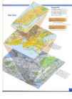
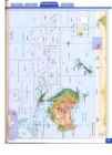
Changing Scale T he larg e sc al e map of New York 's lower Manharran (top) sh ows a small area with a large amounr of derail. T he small sca le m ap of New Yo rk State (bottom) is a lar ge area with a
Map Scale small amo u nr of de tail . o 2 mile s
IJ 11I1111111111111111111111111 111 inches One inch represe nts 1 mile , i , i i I o 10 20 30 40 50 kilometers
WlllllllllIIIIIIII11111111111~111111111~ 1111 1 " 1 centimeters One centimeter represen ts 10 kilometers Latitude and Longitude NORTH POLE
Since an cient time s, mapmak ers, geographers, an d navigarors have work ed
to develop a system fo r accu rate ly loca tin g places o n th e Eart h. O n a /
l kl o re Fo di t i on r al tra O Folk lo elem re can ents c the , it e ontain r s e ever ometim qually c ligious y e o o prac day life s mund ncerns r mythi n t . a it c narr ical an Folklore ne tra self wit io a d t freq d h conf tive pa he es uent itions o la c
e n t, a r tm K ap a l e 1 B H fo r s q m ) (4 5 s rvie of th p an ABC K prov innisva Ove com ides ra esta qual te re it y r to in lated eal vest 2015 ors s service . Pro ince s qual ity a fessiona inno nd c lism vatio o ns t , one n ma ant of th inve e lea kes us stor ding esta orien te co ted Esto mpa real n ia . nies in Locat Tallin ed in th
- '.-.about 1 7 - 1 9@) k n o wt h a t t h e i rc h o i c eo f h o m ei s u n u s u a l living in the tree tops? Dan Garner, a -:: surgoo B f o u n dt h a t c r e a t i n tgh e i rd r e a mh o m ew a se a s y from Gloucestershire, certainlythinks . .: thisis the wayto go up in the world. C w a n t e dt o l i v el i k e p e o p l ew o u l d h a v er n t r a d i to n a \-henour familybecameshort of spaceat home castles -: :olution was to build a luxury tree housein the 40 D converted an ancientburlding intoa modernhome -::ien. The tree houseis built into a sprucetree six 3 W h a t d o J o n a t h a nR i d l e y - J o n ae ns d S h a n o n
- '.-.about 1 7 - 1 9@) k n o wt h a t t h e i rc h o i c eo f h o m ei s u n u s u a l living in the tree tops? Dan Garner, a -:: surgoo B f o u n dt h a t c r e a t i n tgh e i rd r e a mh o m ew a se a s y from Gloucestershire, certainlythinks . .: thisis the wayto go up in the world. C w a n t e dt o l i v el i k e p e o p l ew o u l d h a v er n t r a d i to n a \-henour familybecameshort of spaceat home castles -: :olution was to build a luxury tree housein the 40 D converted an ancientburlding intoa modernhome -::ien. The tree houseis built into a sprucetree six 3 W h a t d o J o n a t h a nR i d l e y - J o n ae ns d S h a n o n
- '.-.about 1 7 - 1 9@) k n o wt h a t t h e i rc h o i c eo f h o m ei s u n u s u a l living in the tree tops? Dan Garner, a -:: surgoo B f o u n dt h a t c r e a t i n tgh e i rd r e a mh o m ew a se a s y from Gloucestershire, certainlythinks . .: thisis the wayto go up in the world. C w a n t e dt o l i v el i k e p e o p l ew o u l d h a v er n t r a d i to n a \-henour familybecameshort of spaceat home castles -: :olution was to build a luxury tree housein the 40 D converted an ancientburlding intoa modernhome -::ien. The tree houseis built into a sprucetree six 3 W h a t d o J o n a t h a nR i d l e y - J o n ae ns d S h a n o n
- '.-.about 1 7 - 1 9@) k n o wt h a t t h e i rc h o i c eo f h o m ei s u n u s u a l living in the tree tops? Dan Garner, a -:: surgoo B f o u n dt h a t c r e a t i n tgh e i rd r e a mh o m ew a se a s y from Gloucestershire, certainlythinks . .: thisis the wayto go up in the world. C w a n t e dt o l i v el i k e p e o p l ew o u l d h a v er n t r a d i to n a \-henour familybecameshort of spaceat home castles -: :olution was to build a luxury tree housein the 40 D converted an ancientburlding intoa modernhome -::ien. The tree houseis built into a sprucetree six 3 W h a t d o J o n a t h a nR i d l e y - J o n ae ns d S h a n o n
RUNNING HEAD: RUSSIA Russia Throughout the History U.S Government Table of Contents 1. Introduction 2. History of Russia 3. Russia nowadays 4. Important people in Russia throughout the history 5. Conclusion 6. References Introduction- Russia Throughout the History Russia is a one of the biggest countries is the world. The first clues about Russian history are from as early as the 9th century. Russia has suffered through rough times in war, mad leaders and tough life amongst the locals. Over times the country has had several different names and political systems. They have been an empire ruled by a czar, a communist nation, and a democratic federation. Nowadays the country's official name is the Russian Federation ("Basic facts about,").
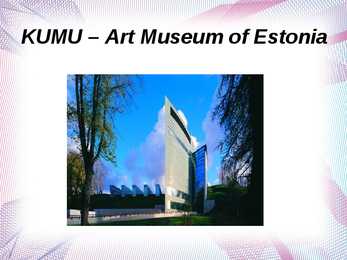
T h e m us e um o p e ne d o n 1 7 Fe b rua ry 2 0 0 6 . The construction of Kumu stretched on for a long period and, during this time, the concept of the museum also changed: the building that had initially been planned as a national gallery became a museum that functions on two levels: collections of Estonian art starting from the early 18th century are displayed on the third and fourth floors, and a modern art gallery is on the fifth floor. Art predating World War II is exhibited on the third floor; the fourth floor houses an exhibition of works from the period of Soviet occupation. On Kumu's fifth floor, there are exhibitions of contemporary art from Estonia and abroad. It is Kumu's ambition to constantly participate in the Estonian and international art worlds, to which a contribution is made by the 250 seat auditorium, with its film programme, performances, concerts, seminars and conferences, the educational centre, with programmes


Kõik kommentaarid