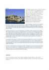
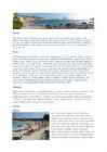
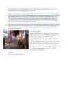
Ibiza Independed work Enelin Paistu LM08 Ibiza Ibiza is an island in the Mediterranean Sea 79km off the coast of the city of Valencia in Iberian Peninsula Spain. It is the third largest of the Balearic Islands, an autonomous community of Spain. With Formentera, it is one of the two Pine Islands or Pityuses. Its largest cities are Ibiza Town (Catalan:Vila d'Eivissa or simply Vila), Santa Eulària des Riu and Sant Antoni de Portmany. Eivissa is the official Catalan name (Catalan pronunciation:, locally. The name in Spanish is Ibiza . In British English, the name is usually pronounced in an approximation of the Spanish while in American English the pronunciation is more anglicized The island is well-known for its summer club parties which attract large numbers
I. Portugal ABOUT Photo Location of Portugal (dark green) Portugal (Portuguese: Portugal, IPA: [putua]; officially the Portuguese Republic, Portuguese: República Portuguesa) is a country located in Southwestern Europe, on the Iberian Peninsula. It is the westernmost country of mainland Europe, and is bordered by the Atlantic Ocean to the west and south and by Spain to the north and east. The Atlantic archipelagos of the Azores and Madeira are Portuguese territory as well. The country is named after its second largest city, Porto, whose Latin name was Portus Cale. SETTLEMENT The land within the bo
Tartu Secondary School of business JAMAICA Form 10 A Tartu 2007 Introduction.................................................................................................................................3 Geography...................................................................................................................................3 History.........................................................................................................................................3 Economy..................................................................................................................................... 4 Econometrics...............................................................................................................................6 Climate................................................................................................
Bora Bora Today the island is almost entirely dependent on tourism. Bora Bora, as you know is a paradise for honeymooners. This island offers blue skies, blue sea, golden sands and green flora. Vaitape is the largest city of island Bora Bora Some of the bigger industries on the island include deep-sea fishing, with exports going mainly to Japan, as well as mother-of-pearl and pearl production. Agricultural practices produce sugar, vanilla, rum, and copra (used to extract coconut oil). Despite all of these activities, tourism is by far the leading economic contributor. The island has several hotels to cater to tourists, including twelve 4 and 5-store places like Club Med, for example. 3 Bora Bora experiences a tropical, humid climate with relatively stable temperatures year- round. The island is characterized by its volcanic rock mountains and raised coral beds found a
N. A. Vavilov ASPECTS OF BRITISH HISTORY Н. А. Вавилов КРАТКАЯ ИСТОРИЯ ВЕЛИКОБРИТАНИИ Учебное пособие на английском языке Москва Институт международного права и экономики имени А. С. Грибоедова 2008 2 УТВЕРЖДЕНО кафедрой лингвистики и переводоведения Вавилов Н.А. Краткая история Великобритании: Учебное пособие на английском языке. – 2-е изд., пересмотр. и испр. – М.: ИМПЭ им. А.С. Грибоедова, 2008. ?
Malestrom Major Rivers N am e Continent Out fl o w T o tal Lengt h (mi.) Nile Africa Mediterran ean Sea 4,1 60 Am azo n South Am erica Atlantic Oce an 4,000 Ch ang (Yangtze) Asia East China Sea 3,964 M ississippi-M iss o u ri N o rt h Am eri ca Gul f of Mexico 3,710 Major Deserts Name Continent Area (sq. m i.)
Ireland is the third largest island in Europe. It lies in between the Atlantic Ocean and the Irish Sea. Politically it is divided into a sovereign state, the Republic of Ireland, that covers about five-sixths of the island (south, east, west and north-west), and Northern Ireland, which is part of the United Kingdom, covering the northeastern sixth of the island.[1] The name 'Ireland' derives from the name Ériu (in modern Irish, Éire) with the addition of the Germanic word 'land'. The population of the island is just under 6 million (2006); just over 4.2 million in the Republic of Ireland[2] (1.6 million in Greater Dublin[3]) and just over 1.7 million in Northern Ireland[4] (0.6 million in Greater Belfast[5])). Politics Politically, Ireland is divided into: · The Republic of Ireland, with its capital Dublin. · Northern Ireland, which is part of the United Kingdom, Geography A ring of coastal mountains surrounds low central plains. The highest peak is Carrauntuohill , which is 1,
Country Study Mari-Liis Luukas 11c The British Isles Administrative / d'mnstrtv / haldus- Self-governing / self'gvn / isemajandav, iseseisev Legislative assembly/ 'ledsltv 'sembl/ seadusandlik kogu The British Isles is the name of a group of islands washed by the North Sea in the east and the


Kõik kommentaarid