Vajad kellegagi rääkida?
Küsi julgelt abi LasteAbi
Logi sisse

Temperate grassland worksheet (0)

1 Hindamata
Punktid

Lõik failist


http://www.geo.ut.ee/kooligeo/loodus/rohtlad.htm 
Temperate Grassland 
Worksheet 
 
1.  Where is temperate grassland situates?   
Temperate grasslands are  located  in the mid-latitudes.  There  are six large  areas  of 
temperate grassland: the Pampas in  South  America, the  Veld  in  Africa , the 
Canterbury  Plains in New  Zealand , the  Murray -Darling  Basin  in Australia, the  Prairies  
in North America and the Steppes in Central  Asia
2. Colour the distribution of temperate grassland on the map. 
 
 
3. How is temperate grassland called in these  regions ?  
Eurasia - steppe 
Hungary - puzda 
North America - prarie 
South America -  pampa  
South Africa - veldt 
4. What is  forest  steppe (forest steppe – metsastepp)?  
A forest steppe is a temperate-climate ecotone and  habitat  type composed of grassland 
interspersed with areas of woodland or forest. 
5. Describe the climate of temperate grassland
Temperate grasslands have a temperate continental climate, which is cooler  than  savannas. 
Temperate grasslands have  warm , humid  summers  with an  average  temperature of 18° C 
and cool, dry winters with an average temperature of 10° C. Most of the rain falls as 
convection rain in the  summer  and sometimes frost and  snow  may  occur  in the  winter
6. What is the  role  of wildfires in the temperate grassland  plants ’ lifecycle?                  
Wildfires play a very  important  role. They  allow  the grasslands to be  open  and free of trees 
and  shrubs . Any seedling of a tree that appears is  killed  off by the  intense  heat. If the  fire  
does not  clear  out the seedlings, the grasslands would become a shrubland  changing  
forever. Remarkably, the plants in the grasslands have adapted to the wildfires that  come  
through, and actually need  them  to  keep  healthy and  grow  new vegetation in the  spring  
7. How are plants adapted to life in temperate grassland? (vt. ka õpik lk 61)                   
During  a fire,  while  above- ground  portions of grasses may perish, the  root  portions  survive  to 
sprout  again . Some  prairie  trees have thick  bark  to resist fire. Prairie shrubs readily resprout 
after fire.  Roots  of prairie grasses  extend   deep  into the ground to absorb as much moisture 
as they can Extensive root systems prevent grazing  animals  from pulling roots out of the 
ground. Prairie grasses have  narrow  leaves which  lose  less water than broad leaves. 
Grasses grow from  near  their  base , not from tip, thus are not permanently damaged from 
grazing animals or fire. Many grasses take advantage of exposed, windy  conditions  and are 
wind pollinated.  Soft  stems  enable  prairie grasses to bend in the wind 
Priit Pensa  
 
Tartu Veeriku Kool 
http://www.geo.ut.ee/kooligeo/loodus/rohtlad.htm 
 8. Name some temperate grassland plants. (vt. ka õpik lk 64-65)  
Rhubarb, sweet vernal, Indian  grass , purple coneflower, pampas grass 
9. Describe the  soil  of temperate grassland. (vt. õpik lk 61)  
 The soil of the temperate grasslands is deep and  dark .  The  upper  layers are the most  fertile  
because of the buildup of many layers of dead  branching  stems and roots.  This  organic  
mater on the surface and in the dead roots  provide  a great  degree  of nourishment for the 
living  plants.  
10. Why are temperate grassland soils very fertile? (vt. õpik lk 61)   
Calfication is the dominat soil-forminf  process  in semiarid regions. When this process works 
on loess that itself is rich in  calcium , the world’s most fertile soils are created, the 
chernozems. 
11. How are animals adapted to life in temperate grassland?  The animals that  live  in 
grasslands have adapted to dry, windy conditions. There are grazing animals (that eat the 
grass), burrowing animals, and their predators;  insects  are abundant. A moderate of level 
species  diversity  exists on a grassland.  
12. Name some temperate grassland animals.   
Rhea , saiga, Mongolian gerbil, Prairie dog,  bison , coyote,  
13. What cultivated plants are  grown in temperate grassland?                                                    
Perennial ryegrass and White Clover  
14. How are gullies (gully –  uhtorg
formed and how do they restrict human activity
(vt. õpik lk 62)
  
gully is a landform created by  running  water, eroding sharply into soil,  typically  on a 
hillside. Gullies resemble large ditches or small valleys, but are  metres  to tens of metres in 
depth and  width . When the gully formation is in process, the water flow  rate  can be 
substantial, which  causes  the significant deep cutting action into soil.  
15. What environmental problems occur in temperate grassland
?  
Few natural temperate grassland regions  remain  because most have been turned into farms 
or grazing land. This is because they are  flat , covered with grass and have a rich soil. 
Overgrazing, ploughing, and  excess  salts  left   behind  by irrigation waters  harm  temperate 
grasslands. Strong winds blow loose soil from the ground after ploughing, especially during 
droughts. 
 
TV H 1-7 lk 26-28 
 
 
http://www.blueplanetbiomes.org/world_biomes.htm 
http://www.ucmp.berkeley.edu/exhibits/biomes/index.php 
http://www.ucmp.berkeley.edu/glossary/gloss5/biome/ 
http://www.mbgnet.net/ 
http://www.worldbiomes.com/ 
http://www.thewildclassroom.com/biomes/ 
http://kids.nceas.ucsb.edu/biomes/index.html 
http://www.world-builders.org/lessons/less/biomes/introbiomes.html 
http://library.thinkquest.org/C0113340/main.php?section=biomes 
http://www.cotf.edu/ete/modules/msese/earthsysflr/biomes.html 
http://www.marietta.edu/~biol/biomes/biome_main.htm 
http://www.runet.edu/~swoodwar/CLASSES/GEOG235/biomes/intro.html 
http://bcs.whfreeman.com/thelifewire/content/chp56/5602002.html 
Priit Pensa  
 
Temperate grassland worksheet #1 Temperate grassland worksheet #2
Punktid 50 punkti Autor soovib selle materjali allalaadimise eest saada 50 punkti.
Leheküljed ~ 2 lehte Lehekülgede arv dokumendis
Aeg2016-11-21 Kuupäev, millal dokument üles laeti
Allalaadimisi 1 laadimist Kokku alla laetud
Kommentaarid 0 arvamust Teiste kasutajate poolt lisatud kommentaarid
Autor 300095 Õppematerjali autor
1. Where is temperate grassland situates?
2. Colour the distribution of temperate grassland on the map.
3. How is temperate grassland called in these regions?
4. What is forest steppe (forest steppe – metsastepp)?
5. Describe the climate of temperate grassland.
6. What is the role of wildfires in the temperate grassland plants’ lifecycle?
7. How are plants adapted to life in temperate grassland? (vt. ka õpik lk 61)
8. Name some temperate grassland plants. (vt. ka õpik lk 64-65)
10. Why are temperate grassland soils very fertile? (vt. õpik lk 61)
11. How are animals adapted to life in temperate grassland?
12. Name some temperate grassland animals.
13. What cultivated plants are grown in temperate grassland?
14. How are gullies (gully – uhtorg) formed and how do they restrict human activity? (vt. õpik lk 62)
15. What environmental problems occur in temperate grassland?

Kasutatud allikad

Sarnased õppematerjalid

thumbnail
2
doc

Geograafia KT-8.klass

2. Where is prairie, pampas, steppe, and veldt situated? Eurasia­Steppe, North America-Prairie, South America­Pampa, South Africa­Veldt 3. Using the climate diagram describe the climate of the region. Temperate deciduous forest -Well-defined seasons with a distinct winter characterize this forest biome. Moderate climate and a growing season of 140-200 days during 4-6 frost-free months distinguish temperate forests. Temperature varies from -15° C to 25° C. Precipitation (750-1500 mm) is distributed evenly throughout the year. Temperate grassland- Semiarid, continental climates of the middle latitudes typically have between 25 cm and 50 cm of precipitation a year. Much of this falls as snow, serving as reservoir of moisture for the beginning of the growing season. Warm to hot summers are experienced, depending on latitude. In the winter, grassland temperatures can be as low as

Inglisekeelne geograafia
thumbnail
2
docx

All studied biomes

Some of the animals in the taiga hibernate in the winter, some fly south if they can, while some just cooperate with the environment. GrasslandsGrassland biomes can be found in the middle latitudes. They can have either moist continental climates or dry subtropical climates. There are two different types of grasslands; tall-grass, which are humid and very wet, and short-grass, which are dry, with hotter summers and colder winters than the tall-grass prairie. In the winter, grassland temperatures can be as low as -40° F, and in the summer it can be as high 70° F. There are two real seasons: a growing season and a dormant season. Deciduos forest The average annual temperature in a deciduous forest is 50° F. The average rainfall is 30 to 60 inches a year. In deciduous forests there are five different zones. The deciduous forest has four distinct seasons, spring, summer, autumn, and winter. In the autumn the leaves change color

Inglisekeelne geograafia
thumbnail
5
doc

Savanna

primarily of C4 grasses. Savannas are also characterised by seasonal water availability, with the majority of rainfall being confined to one season of the year. Savannas can be associated with several types of biomes. Savannas are frequently seen as a transitional zone, occurring between forest and desert or prairie. Although the term savanna is believed to have originally come from a Native American word describing "land which is without trees but with much grass either tall or short", by the late 1800s it was used to mean "land with both grass and trees". It now refers to land with grass and either scattered trees or an open canopy of trees. Changes in fire management Savannas are subject to regular fires and the ecosystem appears to be the result of human use of fire. For example Native Americans created

Inglise keel
thumbnail
4
sxw

Temperate deciduous forests, woodlands and shrub

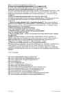
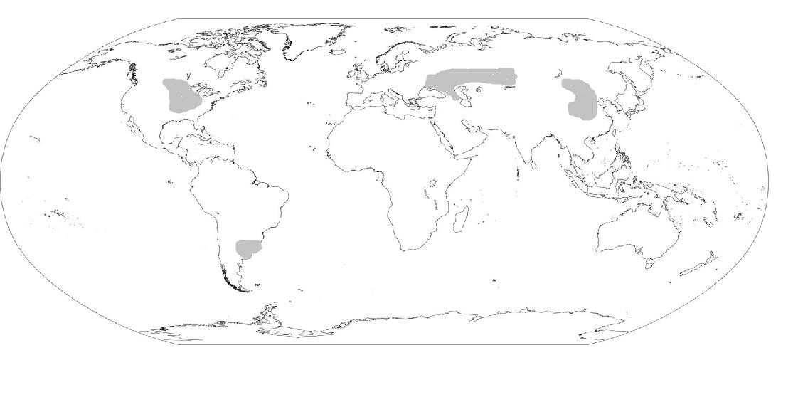
Temperate deciduous forests, woodlands and shrub Tartu 2008 Location: Temperate forests are typical of all European continent, the Eastern region of Asia (in special, Chinese and Japan) and North America. Also are finded in tempered areas of South America. Climate: The average temperature in temperate forests is 50° F. Summers are mild, and average about 70° F, while winter temperatures are often well blow freezing. The average yearly precipitation is 30-60 inches. This precipitation falls throughout the year, but in the winter it falls as snow. There are four seasons in this biome, with warm summers and cold winters, often snowy. In autumn, the leaves change color and fall from the trees. The leaves decay on the forest floor, so the soil is very rich.

Inglise keel
thumbnail
9
doc

Topic - Canada 2

The capital of Canada is Ottawa. Other large cities are Montreal, Toronto, Vancouver, Winnipeg and Quebec. 2. Geographical position Canada is a huge country in the continent of North America. It is bordered with the Atlantic Ocean in the east, the Pacific Ocean in the west, the United States of America in the south and the Arctic Ocean in the north. Canada is a vast country, with a territory of 3.8 million square miles of land and fresh water it is the second biggest country in the world after Russia. Canada covers most of the northern part of North America. Canada has over 151,480 miles of coastline. Most of Canada's human population lives along its southern border. 3. Relief Canada's geography is very diverse. It has huge lakes, evergreen forests, prairies, meadows and beautiful mountains

Inglise keel
thumbnail
7
doc

Canada

This fact, coupled with the grandeur of the landscape, has been central to the sense of Canadian national identity. 2. Geographical position Canada is the second largest country in the world after Russia. In the Arctic, Canada reaches almost as far north as Greenland. To the south it extends to the same latitude as southern France. The distance from Canada's west coast, the Pacific Ocean, to its east coast, the Atlantic Ocean, is farther than from North America to Europe. Canada's total land area includes thousands of adjacent islands, notably Newfoundland in the east and those of the Arctic Archipelago in the north. In longitude Canada extends from approximately 52° to 141° W, a distance that spans six time zones. In latitude it extends from approximately 42° to 83° N. With its vast Arctic and subarctic territories, Canada is often considered a country only of the far north; however, the peninsula of southern Ontario juts deeply south into the heartland

Inglise keel
thumbnail
6
doc

Topic - Canada

national festivals. Cultural diversity makes Canada even more interesting. In spite of this, in recent years there is a strong movement in French-speaking Quebec to become an independent country. There are many different native people throughout Canada like the Crees, Mohawks, Troquois and Sioux. In the north of the country, the Inuit (Eskimos) now have a self-governing homeland called Nunavut, meaning our land. It is over two million square kilometers and it is inhabited by 17,500 Inuits. The national symbol of Canada is the maple leaf. The national tree is the maple. Canada is also the most tolerant societies in the world because only 13% of Canadians say that they would object their children marrying somebody of a different race, compared with 32% in the USA. Canada's political structure is independent constitutional monarchy and head of state is Elizabeth ll

Inglise keel
thumbnail
4
doc

Kanada referaat

To most canadians this region is quite remote since 75 % of the population lives within 300 km of the US border. The North is home to over 85 000 people, and a great variety of wildlife. It's so cold that the earth is frozen for most of the year and never thaws more than a metre from the surface. This permanently frozen layer of earth is called permafrost. Canada's two million lakes cover about 7,6 % of Canada's land. Canada has very famous lakes called the Great Lakes which includes seven lakes: Lake Huron (which is also the biggest lake of Canada), Lake Great Bear, Lake Superior, Lake Great Slave (also the deepest lake, with a depth of 614 m), Lake Winnipeg, Lake Erie and Lake Ontario. They are also the biggest lakes in Canada. The longest river in Canada is the Mackenzie River, which is 4241 km long. It runs through the Nortwest Territories. Other larger and more important

Inglise keel


Meedia

Kommentaarid (0)

Kommentaarid sellele materjalile puuduvad. Ole esimene ja kommenteeri


Sellel veebilehel kasutatakse küpsiseid. Kasutamist jätkates nõustute küpsiste ja veebilehe üldtingimustega Nõustun