http://www.geo.ut.ee/kooligeo/loodus/rohtlad.htm Temperate Grassland Worksheet 1. Where is temperate grassland situates? Temperate grasslands are located in the mid-latitudes. There are six large areas of temperate grassland: the Pampas in South America, the Veld in Africa, the Canterbury Plains in New Zealand, the Murray-Darling Basin in Australia, the Prairies in North America and the Steppes in Central Asia. 2. Colour the distribution of temperate grassland on the map. 3. How is temperate grassland called in these regions? Eurasia - steppe Hungary - puzda North America - prarie South America - pampa South Africa - veldt 4. What is forest steppe (forest steppe – metsastepp)?
EurasiaSteppe, North America-Prairie, South AmericaPampa, South AfricaVeldt 3. Using the climate diagram describe the climate of the region. Temperate deciduous forest -Well-defined seasons with a distinct winter characterize this forest biome. Moderate climate and a growing season of 140-200 days during 4-6 frost-free months distinguish temperate forests. Temperature varies from -15° C to 25° C. Precipitation (750-1500 mm) is distributed evenly throughout the year. Temperate grassland- Semiarid, continental climates of the middle latitudes typically have between 25 cm and 50 cm of precipitation a year. Much of this falls as snow, serving as reservoir of moisture for the beginning of the growing season. Warm to hot summers are experienced, depending on latitude. In the winter, grassland temperatures can be as low as -40° C, and in the summer it can be as high 20° C. There are two real seasons: a growing season and a dormant season. The growing season is when there
The Prarie Provinces Main Facts The Prairies comprise the states of Alberta, Saskatchewan and Manitoba Covers about 2,1 million square kilometers. About 5,7 million people live in that region. What is a Prarie? Prarie (aslo known as a temperate grassland) is a treeless ecozone in North America. Different names in different countries. Only about 400 mm per year. Hot summers and cold winters. Humans and the Prairies Almost 95 % of the Prairies are converted into farmland. The biggest towns are Calgary, Saskatoon and Winnipeg. The main argiculture industries are wheat, barely and canola. Rich in oil and natural gas. Fauna
a Mediterranean climate. Much of the southeast is temperate. · Climate change has become an increasing concern in Australia in recent years, with many Australians considering protection of the environment to be the most important issue facing the country. Australian nature · Eastern Australia is marked by the Great Dividing Range and it consists of low hills and the highlands are typically no more than 1,600 metres. There are large areas of grassland. · The landscapes of the northern part of the country, with their tropical climate, consist of woodland, grassland and desert. · At the northwest corner of the continent is the sandstone cliffs and gorges of The Kimberley · Australia has the longest coral reef - The Great Barrier Reef. · At 2,228 metres Mount Kosciuszko on the Great Dividing Range is the highest mountain on the Australian mainland. http://www.youtube.com/watch? v=avLWMHZR5dk Australian animals
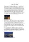
CANADA FACTFILE Area: 10 million square km Population: 35 million Capital: Ottawa Official languages: English, French Currency: Canadian dollar Number of Native Canadians: 800 000 75% of Canadians live in cities/towns. 80% live within 200 (160) km of US border. Largest city: Toronto (4.7 million) Northern Canada: mainly forest, tundra, ice and snow Western Canada: Rocky Mountains Highest mountain: Mount Logan (5 951 m) West-central Canada: prairie grassland Most important river: St Lawrence Longest river: Mackenzie (4,241 km) Niagara Falls: largest falls in the world Also 2 million lakes, over 60% of the world's lakes Industry: mining, oil and gas, paper, motor vehicles, fishing Agriculture: wheat, fruit and vegetables Canadian wildlife: polar bear, moose, caribou, elk, brown bear, grizzly bear, several kinds of wild cat, whales off east/west coasts Over 500 different kinds of birds Central Canada: short hot summers, long cold winters
area. Protection · The natural beauty of the Chiltern hills is threatened by traffic noise, climate change and urban development. · The Chilterns Conservation Board (CCB)has produced the five-year scheme to help protect the area. · The Chilterns were made an Area of Outstanding Natural Beauty (AONB) in 1965 and attract tens of thousands of visitors each year. · The AONB is intended to protect the steep chalk escarpments, grassland, chalk-bedded rivers, ancient beech woodland and brick-and-flint villages. ·
Peat bogs (code 412) was in Estonia between 1990-2000 122 297 he It means that code 412 decreased by the 300 he 4. The Land Monitoring Service within Copernicus offers a wide array of products; how many High Resolution Layers can be viewed in the Pan- European section? Name them below The European Environment Agency (EEA) of the in 2015 has announced the release high Resolution Layers (HRL). There are 4 types: "Imperviousness", "Forests", "Grassland" and "Water & Wetness" 5. The EU Climate Adaptation Platform contains information about exposure to a number of climatic threats. Estonia is relatively safe, but what is the potentially flooded area in the core city (%) in Copenhagen? Copenhagen area potentially affected by flooding is 21-40% 6. According to Eurostat, how much wind power was consumed in Estonia in 2016? Wind power was consumed in Estonia in 2016 -51.1 TOE ( 2,138.4 terjoule) 7
European Environmental Databases 2018 1. According to Corine Land Cover, has the total area of natural grasslands increased or decreased in Estonia between 1990 and 2006? By how many hectares? According to CLC the total area of natural grassland in Estonia has increased by 39 779ha. 2. And in Europe? In Europe it has also increased, by 19 007 228ha. 3. What about "Broad-leaved forest" (Corine Land Cover code 311) in Estonia? Increased or decreased? By how many hectares? Broad-leaved forests have increased by 43 8834ha. 4. What was the water exploitation index for Emajõgi sub-basin in the summer of 2012? 0.03% 5. When did Estonia emmitted more Ktons of CO2, in 2015 or in 1990? What is the difference between both years in ktons?
There are a lot of straight drainage systems, ditches and dykes near the forests and farmlands which used to be excessively damp. This contributes a lot to the flooding in the spring, because the water will reach the main river in a very short time. The flood plain grasslands located along the riverbanks are the typical example of plant communities formed as a result of the joint influence of river floods and human activities. They used to maintain the grassland through hay-making but now the endorsements are very low and owners don't take care of the land at the river bank. Some scientists think that letting the grasslands grow untouched is good for the biodiversity, but this is not the case here. For example eagles, which hunt on these grounds just abandon these areas and move on to nest somewhere else. Also the growth of the bigger trees is hindered by the underwood vegetation, which consist of willow, alder and aspen.
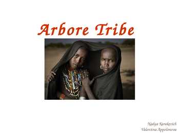
Name The Arbore culture is ancient but not static. Arbore is said to be the name of the first ancestor of the Arbore Girl tribe. Arbore "ar" means land and "bore" also means bull. Therefor Arbore means "land of Bulls." They actually call themselves "Hoor", in reference to their dependence on the inundated flats. Habitat, location The Arbore or Erbore are Cushitic agro-pastoral people dwelling in southwestern Omo Valley Ethiopia. The Arbore territory is a savanna grassland around 500 m elevation. The Weito River (local name Lima) flows from north to south and runs into the Lake Chew Bahir (Chelbz), on the border between Ethiopia and Kenya. The people live along the lower part of the river. Population Their population is estimated to be around 7000. The Arbore consists of a northern division called Gondorobba, and a southern division called Marle. The northern Arbore have a close
were unlike those that were found anywhere else. Among te animals were kangaroos and wombats and koalas. They carry their babies in pouches. There were platypuses and spiny anteaters, too the only mammals in the world that lay eggs. Among the strange birds were emus, lyrebirds, and black swans. The early settlers on the coast were suht in between the mountains and the sea. For years they couldn't make their way across the mountains. When they did, they found great streches of grassland. Some of the early settlers had been sheepmen in Britain. They saw that the grasslands would be a wonderful place for raising sheep. They knew that wool stands shipping well. They knew, too, that it is worth enough to pay for shipping it long distances. Many started sheep farms. Before long Australia became the greatest wool-producing country in the world. In some cases cattle were raised on the grassland instead of sheep. But beef and butter are not as easy to ship as wool.
Some of the animals in the taiga hibernate in the winter, some fly south if they can, while some just cooperate with the environment. GrasslandsGrassland biomes can be found in the middle latitudes. They can have either moist continental climates or dry subtropical climates. There are two different types of grasslands; tall-grass, which are humid and very wet, and short-grass, which are dry, with hotter summers and colder winters than the tall-grass prairie. In the winter, grassland temperatures can be as low as -40° F, and in the summer it can be as high 70° F. There are two real seasons: a growing season and a dormant season. Deciduos forest The average annual temperature in a deciduous forest is 50° F. The average rainfall is 30 to 60 inches a year. In deciduous forests there are five different zones. The deciduous forest has four distinct seasons, spring, summer, autumn, and winter. In the autumn the leaves change color
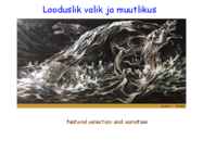
evotutor.org/Selection/Sl5A.html suunav valik The fossil lineage of the horse provides a remarkable demonstration of directional succession. The full lineage is quite complicated and is not just a simple line from the tiny dawn horse Hyracotherium of the early Eocene, to today's familiar Equus. Overall, though, the horse has evolved from a small-bodied ancestor built for moving through woodlands and thickets to its long- legged descendent built for speed on the open grassland. This evolution has involved well- documented changes in teeth, leg length, and toe structure. stabiliseeriv valik – inimese sünnikaal 13700 sündi UK 1935-1946 Elunemus 4 nädalasena 3,6kg sünnikaal minimaalne suremus le po ut lik Va
for development, Halifax Peninsula and Mainland Halifax. It forms a significant part of the Halifax urban area. Residents of the former city are referred to as "Haligonians Halifax Calgary is the largest city in the Province of Alberta, Canada. It is located in the south of the province, in an area of foothills and high plains, approximately 80 km (50 mi) east of the front ranges of the Canadian Rockies. The city is located in the Grassland region of Alberta. Calgary is the third largest civic municipality, by population in Canada. In the Canada 2006 Census, the city had a population of 988,193[2] and the CMA had a population of 1,079,310.[3] As of the 2009 civic census, Calgary's population was 1,065,455 and the CMA had a population of 1,182,446.[4] Greater Calgary is estimated to be the fourth largest metropolitan in the country after Toronto, Montreal, and Vancouver according to
including fire, ambulance, police, parks, roads, sidewalks, public transit, drinking water, stormwater, sanitary sewage and solid waste. Calgary Calgary is the largest city in the Province of Alberta, Canada.It's population is about 1 065 000 people. It is located in the south of the province, in an area of foothills and high plains, approximately 80 km east of the front ranges of the Canadian Rockies. The city is located in the Grassland region of Alberta. Calgary is the third largest civic municipality, by population in Canada. Located 300 km due south of Edmonton, statisticians define the narrow populated area between these cities as the "Calgary-Edmonton Corridor." Calgary is the largest Canadian metropolitan area between Toronto and Vancouver. Calgary is well-known as a destination for winter sports and ecotourism with a number of major mountain resorts near the city and metropolitan area. Economic activity in Calgary
ulatuses, liigilise koosseisus ning koosluse tootlikkuse tahtlikus mõjutamises. Kasutatud kirjandus · Kukk, T, Kull, K. 1997. Puisniidud. Estonia Maritima 2. · Kukk, T. 2004. Eesti taimede kukeaabits. Varrak, Tallinn · Luhamaa, H., Iikonen, I., Kukk, T. 2001. Läänemaa pärandkooslused. Pärandkoosluste Kaitse Ühing, Tartu-Turku · Pärtel, M., Mändla, R. and Zobel, M. 1999. Landscape history of a calcareous grassland in Hanila, western Estonia, during the last three hundred years. Landscape Ecology · Sammul, M., Kull, K. and Tamm, A. 2003. Clonal growth in a species-rich grassland: results of a 20-year fertilization experiment. Folia Geobot. · Talvi, T. 2001. Pool-looduslikud kooslused: puisniidud, rannaniidud, loopealsed, lamminiidud, puiskarjamaad, aruniidud. Ökoloogiliste Tehnoloogiate Keskus Internetileheküljed 1. Artikkel
Most of the she-marsupials have pouches in which they carry their young. The kangaroo is one Australian animal that everybody knows.There are more than 50 species of kangaroo. They are furry animals that hop on their hind legs. The biggest are red kangaroos, grey kangaroos and euros. The smallest are thekangaroos that belong to the group called rat kangaroos. There are million of kangaroos in Australia. Another Australian marsupial is the wombat. It lives in burrows in grassland areas of Australia and Tasmania. It has short strong legs and long claws for digging burrows.Wombats live in groups and come out to look for food at night. They have poor eyesight but they can smell and hear very well. Their nearest living relatives are koalas. The koala is one of the best known Australian animals. They live in eucalyptus trees,sleeping for 18 hours and eating 1 kilo of leaves each day. They drink almost nothing they get water from the leaves of the trees
due to forestation. Predominantly, forestation has increased on higher parts of relief and advanced at the forest edges. In 1959 the botanic reserve `Halliste wooded meadow' was founded, and in this region the nature protection methods were applied for the first time. The foundation of the reserve could not restrain the overgrowth of flood-plain grasslands with forests in the area. In the 20th century the grassland community in the particular region decreased by 76%. Within the frame of the European Union programme LIFE-Nature, 1994 hectares of flood-plain meadows are planned to be restored in Soomaa National Park by the year 2009. Flood-plain grassland vegetation was studied in Soomaa National Park on two relatively similar moisture regime but different management regime flood-plain grassland community types, in total in 11 flood-plain grassland communities. Standing biomass (per 500 ramets)
Savanna A savanna is a grassland ecosystem with scattered trees or shrubs. In savannas trees are small or widely spaced so that the canopy does not close. It is often believed that savannas are characterized by widely spaced, scattered trees, however in many savanna communities tree densities are higher and trees are more regularly spaced than in forest communities. The open canopy allows sufficient light to reach the ground to support an unbroken herbaceous layer consisting primarily of C4 grasses. Savannas are also characterised by seasonal water availability, with the majority of rainfall being confined to one season of the year. Savannas can be associated with several types of biomes. Savannas are frequently seen as a transitional zone, occurring between forest and desert or prairie. Although the term savanna is believed to have originally come from a Native American word describing "land which is without trees but with ...
musk oxen, elks, moose, lemmings, wolves and foxes. The Taiga biome, also known as coniferous forests is located south of the Tundra region. Taigas are the largest biomes on Earth and they are a major source of oxygen. The Climate there is cold and harsh. Precipitation is low. The growing season is short. Only deciduous trees can grow there since the soil is acidic. Some typical animals are brown bears, foxes, geese, lynxes and moose. Prairies are temperate grassland. They consist of plains of grass that are hot in the summer and cold in the winter. Prairies are made by fires. The soil is rich and the precipitation is medium. The area has very few trees or shrubs so it is very windy. Typical animals are bobcats, antelopes, snakes, rodents, rabbits, badgers, bisons. Prairies are located in Alberta, Saskatchewan and Manitoba. Those regions are called the ,,Bread-basket of Canada" because of the wheat and other grains they get from there. 9. Population
rat kangaroos. They eat grass and leaves and live in groups of about twelve. The koala is one of the best loved Australian animals. The aboriginals named it "the animal that does not drink". They live in eucalyptus trees, sleeping for 18 hours, and eating 1 kilo of leaves and bark each day. Baby koalas are about the size of a bean when they are born. They move into their mother's pouch, which opens to the back. It comes out at the age of 6 months. The wombat lives in burrows in grassland areas of Australia and Tasmania. It has short strong legs and claws for digging burrows. They live in groups and come out to look for food at night. To counterbalance their poor eyesight, they can smell and hear very well. Their nearest relatives are koalas. The possum is a furry animal that lives in the trees. This good climber moves about at night. They live in groups and come out to look for food in the night. Some of them are called
This time in the west. The gold miners of the east had a hard time. Water was very scarce and the roads were bad. But then a railway was built. The west was joined with the east. In 1903 a water-main was built to support the gold-mining centre with water. Some of the early settlers had been sheepmen in Britain. They saw that the grasslands would be a wonderful place for raising sheep. Hey knew that wool stands shipping well, so many started sheep farms. In some cases cattle were raised on the grassland instead of sheep. Many of the people who came to Australia to find gold stayed on to do other kinds of work. They found that Australia has other riches too, such as coal, copper, lead, iron ore, nickel, natural gas etc. The forests have good timber. Along seashores pearls and tortoise shells can be gathered. Other land proved to be good for growing sugar canes and fruit orchards. Of course they needed to buy and sell what was raised. Others needed to
ka kliimavööndi piires. Biomes are climatically and geographically defined as similar climatic conditions on the Earth, such as communities of plants, animals, and soil organisms,[1] and are often referred to as ecosystems. A fundamental classification of biomes is: 1. Terrestrial (land) biomes 2. Aquatic biomes (including Freshwater biomes and Marine biomes) Biomes are often known in English by local names. For example, a temperate grassland or shrubland biome is known commonly as steppe in central Asia, prairie inNorth America, and pampas in South America. Tropical grasslands are known assavanna in Australia, whereas in Southern Africa it is known as veldt (fromAfrikaans). 9. Mis on ökotüüp? Ökotüüp e ökoloogiline rass sarnaselt kohastunud organismid ühe liigi piires (nt lillakas turbasammal). Võib kajastuda süstemaatikas (nt alamliikide eristamine).
~ Lowest recorded temperature Major Ocean Currents ........ Cool ~ currents Warm currents 20'W .. Vegetat ion Unclassified high lands or ice cap Tundra and alp ine tundra Coniferous forest Midlatitude deciduous forest Subtropical broadleaf evergreen fo rest Mixed forest Midlatitude scrubland Midlatitude grassland Desert Tropical seasonal and scrub D Tropical rain forest D Tropical savanna PACIFIC I OCEAN 0' - EQUATOR -+---- --+_------+-------+-------,..--- ----.f ....:lO :;n .----~- ...::: -_+--_:f _n_ ""-+_-- -
the west. Farther west are the bushlands. The real deserts occupy the centre of the Western Plateau. In the very south west there are thin forests of evergreens trees. Australia is the driest inhabited continent, the flattest, and has the oldest and least fertile soils. Only the south-east and south-west corners of the continent have a temperate climate. The northern part of the country, with a tropical climate, has vegetation consisting of rainforest, woodland, grassland, mangrove swamps and desert. Climate is highly influenced by ocean currents, including the El Niño southern oscillation. 4. Land regions Mountains The Great Dividing Range runs along the Pacific ocean. These mountains are very old and much of worn down but the Australian Alps are the highest of them. The highest top Mount Kosciusko is 2228 metres above sea level. It was named by the Polish explorer Count Paul Strzelecki in 1840 in honour of the
(b) 1 Woodland more, dark / unbanded, snails or fewer, light / banded, snails ; 2 better camouflaged / ora ; 3 against, leaf litter / uniform background ; 4 relevant woodland data quote on colour and banding ; 5 Grassland more, yellow / banded, snails or fewer, dark / unbanded, snails ; 6 better camouflaged / ora ; (only award if missed point 2) 7 against, pale / yellow / green / variable, background ; 8 relevant grassland data quote on colour and banding ;
lubiväetiste normide kasutamise korral. Mn väetisi on vaja kui Mn sisaldus on alla 1% mullas. Eesti oludes Ida-Virumaal Narva- Kunda piirkonnas. Mn- väetise liigid : a) mangaansuperfosfaat rohekashall. Mn sisaldus 1,5%, kuni 10kg/ha. b) MnSO4 seemnete puuderdamiseks 100g/ha, vesilahusena 400g/ha, tahke väetisena 10 kg/ha. Mn on toksiline kui mullas on Mn sisaldus üle 50 mg/kg mulla kohta (tee äärtes). 67)Rohusöötade tähtsus Eestis Rohumaa - grassland, grünland Rohumaa mitmeaastaste mesofiilsete taimede kooslus. Rohumma taimed jaot 4 rühma: 1. Kserofiilsed kui transpirats koef on alla 300 nt lambaaruhein 2. mesofiilsed 400-600 nt timut, lusted, haril aruhein 3. hügrofiilsed 700-900 vajavad palju vett. Nt päideroog 4. hüdrofiilsed trans üle 1000. Kasvavad vees. Nt sinihelmikas, aasrebasesaba. Rohumaa taimede erinevus põllukultuuridest: