http://www.geo.ut.ee/kooligeo/loodus/rohtlad.htm Temperate Grassland Worksheet 1. Where is temperate grassland situates? Temperate grasslands are located in the mid-latitudes. There are six large areas of temperate grassland: the Pampas in South America, the Veld in Africa, the Canterbury Plains in New Zealand, the Murray-Darling Basin in Australia, the Prairies in North America and the Steppes in Central Asia. 2. Colour the distribution of temperate grassland on the map. 3. How is temperate grassland called in these regions? Eurasia - steppe Hungary - puzda North America - prarie South America - pampa South Africa - veldt 4. What is forest steppe (forest steppe – metsastepp)?
Temperate deciduous forests, woodlands and shrub Tartu 2008 Location: Temperate forests are typical of all European continent, the Eastern region of Asia (in special, Chinese and Japan) and North America. Also are finded in tempered areas of South America. Climate: The average temperature in temperate forests is 50° F. Summers are mild, and average about 70° F, while winter temperatures are often well blow freezing. The average yearly precipitation is 30-60 inches. This precipitation falls throughout the year, but in the winter it falls as snow. There are four seasons in this biome, with warm summers and cold winters, often snowy. In autumn, the leaves change color and fall from the trees. The leaves decay on the forest floor, so the soil is very rich.
TRANSHUMANT GRAZING SYSTEMS IN TEMPERATE ASIA Merlin-Hans Hiiekivi Authors:J.M.Suttie S.G Reynolds Intro • Temperate Asia has vast areas of grazing lands • Both transhumant and agropastoral systems are common Cold semi-arid Asia • Over most of area thee is little interaction between herding and croping • A major herding skill is getting stock fat summer and autumn to survive the winter • In 20th the livestock industry was collectivized for a period • Most of the countries of th region report serious degradation of their grazing lands. By the least affected is Mongolia
2. Where is prairie, pampas, steppe, and veldt situated? EurasiaSteppe, North America-Prairie, South AmericaPampa, South AfricaVeldt 3. Using the climate diagram describe the climate of the region. Temperate deciduous forest -Well-defined seasons with a distinct winter characterize this forest biome. Moderate climate and a growing season of 140-200 days during 4-6 frost-free months distinguish temperate forests. Temperature varies from -15° C to 25° C. Precipitation (750-1500 mm) is distributed evenly throughout the year. Temperate grassland- Semiarid, continental climates of the middle latitudes typically have between 25 cm and 50 cm of precipitation a year. Much of this falls as snow, serving as reservoir of moisture for the beginning of the growing season. Warm to hot summers are experienced, depending on latitude. In the winter, grassland temperatures can be as low as
frith) is an area with a high density of trees. Forests cover approximately 30% of land and 9.4% of all the planet earth. They are also responsible for regulating our planet's climate and act as large purifiers of airs, by absorbing carbon dioxide, and giving out oxygen. Different types of forests Forests are divided into following main types: o Tropical forest o Subtropical forest o Plantations o Boreal forest o Temperate forest o Seasonal or monsoon forest Tropical and Subtropical Forests Tropical and subtropical forests, also known as rainforests or tropical rainforests, are lavish and ample forests with broad leave tree. They are mostly found at lowlands near the equator - Asia, Africa, South & Central America and on many of the Pacific Islands. Almost 50% forests of the world are tropical and subtropical in nature.
Geography and climate/weather When I think about the UK I think about London and its sights. the second thing that pops into my mind the weather and how they talk and complain that the weather is bad and it is raining, The weather in the UK is actually changeable and it doesn't rain all the time They are in the Temperate climate zone and the Gulf stream affect their weather. so there are no extreme weather conditions Much of the land in England is low lying. forming meadows and pastures Upland areas are generally confined to northern England The Pennines are a range of mountains and hills in Northern England The Midlands' largest city is Burmingan.. It is one of England’s principal industrial and commercial areas. The highest point of the UK is Ben Nevis which is located in Scotland and the
Australia Kaspar Rätsep G1A Australian nature · Australian nature is extremely diverse and interesting. It's the driest inhabited continent, only its south-east and south-west corners have a temperate climate. · The climate of Australia is significantly influenced by ocean currents, which is correlated with periodic drought, and produces cyclones in northern Australia. · Much of the northern part of the country has a tropical summer rainfall (monsoon) climate. The southwest corner of the country has a Mediterranean climate. Much of the southeast is temperate. · Climate change has become an increasing concern in Australia in
· Typical to Mediterranean region and East-Asia 4. Late Agrarian m.m · Very bad situation primeval fields · Population growing necessity much bigger · Forests preserved on slopes of mountains and where infertile soils were. · West Europe, North America 4. Early Industrial m.m · Development of forestry -> timber industry · Wood from boarderlands and colonies · Subequatorial and equatorial regions valuable woods · Temperate zone coniferous woods soft timber · Transport floating of logs, road transport 5. Late Industrial m.m · Ruinous economy Forestry in different regions of the world: 1. Europe 1) West Europe · A lot of forests were destructed during Late Agrarian times. · During the industrialisation only timber industry · Situation has improved timber, paper and cellulose industries in France and Germany 2) Finland, Sweden, Norway
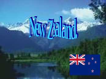
26, 1907. · Area- 268 680 km². Water (%)2.1. · Population - 4,143,279 . · Currency New Zealand dollar. New Zealand geography. · New Zealand is a country in the southwestern Pacific Ocean. · New Zealand comprises two main islands . · NZ has got many smaller islands. · NZ is mountanious country. The highest peak is Aoraki/Mount Cook at 3754 meters. · NZ have an active volcano Mount Ruapehu. · The climate throughout the country is mild, mostly cool temperate to warm temperate, with temperatures rarely falling below 0°C (32°F) or rising above 30°C (86°F) · The climate in West is different from South. In West it´s wet and cold but in south it´s dry and warm. · Continental New Zealand is Subtropical. History. · New Zealand is one of the most recently settled major land masses. · The first New Zealand settlers came to NZ in 800 and 1300 AD . They found a country teeming with birdlife and waters
tree in another way. Releasing the rain at drop size reduces the risk of the thin soil below being washed away so easily. An unstable soil structure could spell disaster for the larger trees. Epiphytes An epiphyte is a plant that grows upon another plant (such as a tree) non-parasitically or sometimes upon some other object (such as a building or a telegraph wire), derives its moisture and nutrients from the air and rain and sometimes from debris accumulating around it, and is found in the temperate zone (as many mosses, liverworts, lichens and algae) and in the tropics (as many ferns, cacti, orchids, and bromeliads). Lianas A liana is any of various long-stemmed, woody vines that are rooted in the soil at ground level and use trees, as well as other means of vertical support, to climb up to the canopy to get access to well-lit areas of the forest. Lianas are especially characteristic of tropical moist deciduous forests and rainforests. Fig trees
Taimed Stepirohi Preeriarohi Piisonirohi Taimed Tulp Krookus Pojeng Õistaimed Loomastik Inimtegevus ● Põllundus ● Loomakasvatus ● Tööstus ● Turism ● Metallurgia Keskkonnaprobleemid ● Heitgaasid ● Tuule- ja vee erosioon ● Muldade sooldumine ja huumusest vaesumine ● Tulekahjud ● Minu vihik ● http://image.slidesharecdn.com/temperategrassland2-11051600345 8-phpapp01/95/temperate-grassland2-6-728.jpg?cb=1305524160 ● https://40.media.tumblr.com/9112f1a989b8a3338073291f0ed53338/ tumblr_njv02rSuBh1s6taa7o1_1280.jpg ● http://www.eatcology.com/wp-content/uploads/2012/02/Terra_Preta.j pg ● https://encrypted-tbn3.gstatic.com/images?q=tbn:ANd9GcSI 3eIy5FXtiXmNqTw2FGNPSKOodsVG9OKLKgwTysfunmqMxFGA ● http://ak6.picdn.net/shutterstock/videos/2251258/preview/stock-foota ge-feather-grass-in-a-steppe.jpg Kasutatud allikad
Bilberry Bilberry Bilberry is any of several Eurasian species of low-growing shrubs, bearing edible, nearly black berries. Bilberries are distinct from blueberries but closely related to them. Bilberryis a plant. The dried, ripe fruit and leaves are used to make medicine. Bilberriesare found in very acidic, nutrient-poor soils throughout the temperate and subarctic regions of the world. Are related to North American wild. It can be picked… Bilberryhas sharp-edged, green branches and black berries, which are ripe for picking in late summer. How it is used Bilberryis used for improving eyesight, including night vision. Some people use bilberry for conditions of the heart. Bilberryis also used for chronic fatigue syndrome, hemorrhoids, diabetes, gout, skin infections, kidney disease, and urinary tract
The Prarie Provinces Main Facts The Prairies comprise the states of Alberta, Saskatchewan and Manitoba Covers about 2,1 million square kilometers. About 5,7 million people live in that region. What is a Prarie? Prarie (aslo known as a temperate grassland) is a treeless ecozone in North America. Different names in different countries. Only about 400 mm per year. Hot summers and cold winters. Humans and the Prairies Almost 95 % of the Prairies are converted into farmland. The biggest towns are Calgary, Saskatoon and Winnipeg. The main argiculture industries are wheat, barely and canola. Rich in oil and natural gas. Fauna
England, and was adopted as a national emblem of England around the time of the Wars of the Roses. Anthem · England does not have an official designated national anthem, as the United Kingdom as a whole has " God Save the Queen". However, the following are often considered unofficial English national anthems: · "I Vow to Thee, My Country" · "Land of Hope and Glory" · "Nimrod" · "Jerusalem" · "Heart of Oak" Climate · England has a temperate climate, with plentiful rainfall all year round, although the seasons are quite variable in temperature. However, temperatures rarely fall below -5 °C (23 °F) or rise above 30 °C (86 °F). Ethnic groups (2006) · 89% White 6% South Asian 3% Black 2% Mixed race 1% Chinese 1% Other Map of England The end
History o Māori were the first to arrive in New Zealand, journeying in canoes from Hawaiki about 1,000 years ago. A Dutchman, Abel Tasman, was the first European to sight the country In 1840, the Treaty of Waitangi was signed, an agreement between the British Crown and Maori Nature New Zealand is made up of two main islands and a number of smaller islands The South Island is the largest landmass of New Zealand New Zealand has a mild and temperate maritime climate with mean annual temperatures ranging from 10 °C in the south to 16 °C in the north. Thanks for watching!
Ksenija Balta · Long jumper Born November 1st 1986 European Indoor Championships 6.87 Coach Andrei Nazarov Gerd Kanter · Discus thrower Born in May 6th, 1979 World Championships 68.94 Third best mark in the world 73.38 Climate · In the northern part of the temperate climate zone · Transition zone between maritime and continental climate · Influenced by the Atlantic Ocean · Average temperature 5.2°C · Sakala and Haanja Uplands Education system · The education system is based on four levels : preschool basic secondary higher education · 589 schools Tartu university · Established by the Swedish king Gustav II Adolf · 1632 · 20 000 students · Highest-ranked in
LONDON KRISTINA KASEMÄGI CONTENTS • GENERAL • HISTORY • CLIMATE • THINGS TO SEE • THINGS TO DO GENERAL o London is the capital city of England and the United Kingdom. o It’s situated in the South East of England with population of 14 million people. HISTORY oLondon is one of the oldest cities in the world, and it was founded by the Romans in 40 A.D. and called Londinium. CLIMATE • London has a temperate marine climate like much of the British Isles, so the city rarely sees extremely high or low temperatures. THINGS TO SEE o THE TOWER OF LONDON o THE LONDON EYE o TOWER BRIDGE o BIG BEN o THE HOUSES OF PARLIAMENT 1 o ST JAMES’S PARK THE TOWER OF LONDON THE LONDON EYE TOWER BRIDGE BIG BEN, THE HOUSE PARLIAMENT 1 AND FAMOUS RED DOUBLE DECKER BUS ST JAMES’S PARK THINGS TO DO IN LONDON You can: o Cross the Thames in a cable car
The Republic of Estonia is a country in Northern Europe. The territory of Estonia covers 45,227 km2 . Tallinn is the capital and largest city of Estonia.The city is an important industrial, political and cultural center, and seaport Estonia is a democratic parliamentary republic and is divided into fifteen counties. Estonia is one of the least-populous members of the European Union. Estonia lies in the northern part of the temperate climate zone Estonia has four seasons of near-equal length. The official language is Estonian.Võro and Seto in southern counties are spoken along with Estonian. The Estonian national flag is a tri-color- blue, black and white. The national currency is the Eestonian kroon. Estonia has over 1,400 lakes. Most are very small, with the largest, Lake Peipsi being 3,555 km² .There are many rivers in the country. The longest of them are Võhandu (162 km), Pärnu (144 km), and Põltsamaa (135 km)
north approximately 40,000 to 60,000 years ago · The first European visited W.A. in 1616 · Population growth was very slow until the significant discoveries of gold were made in the 1890s Geography · Western Australia is bounded by South Australia and the Northern Territory to the east, and the Indian Ocean to the west and north · It's highest peak is the Mt Meharry (1249m) Climate · The southwest costal area is relatively temperate and was originally heavily forested, including large stands of the karri · Average annual rainfall varies from 300 1500 mm (in Estonia 550 880 mm) · Snow usually doesn't fall in W.A. Sport · Australian Football : West Coast Eagles and Fremantle Dockers · Basketball : Perth Wildcats · Cricket : Western Warriors · Netball : West Coast Fever Education · Education in W.A. consists of one year of pre-school at age 5, followed by seven
(200 000) . Government: Federal parliamentary democracy and constitutional monarchy, monarch is Queen Elizabeth II, Governor General is Quentin Bryce and Prime Minister is Kevin Rudd. Climate: Most part of Australia is located in tropics zone. Equatorial climate rules in Queenslands north, and tropical monsoonclimate rules West-Australia and north territory, and queenlands north-western. Subtropical climate remains South- Australia south and New-South-Wales. Temperate zone rules in South-Victoria and in Tasmanite. Midland, west- and south are very dry. Moderate climate is only in east and south-east 400 km coastline and in south-west. Sightseen: Sydney Tower tallest independent tower in sydney Opera in Sydney a symbol for not only a city, but a whole country and continent. Tjuta national park in the desert Great Barrier Reef longest coralpeace Languages that are spoken:
The Republic of Estonia Estonia officially the Republic of Estonia is a country in the Baltic region of Northern Europe. It is bordered to the north by Finland across the Gulf of Finland, to the west by Sweden across the Baltic Sea, to the south by Latvia and to the east by the Russian Federation. The territory of Estonia covers 45,227 km² and is influenced by a temperate seasonal climate. Estonia is a democratic parliamentary republic and is divided into fifteen counties. The capital and largest city is Tallinn. With a population of only 1.4 million, it is one of the least- populous members of the European Union. Estonia was a member of the League of Nations from 22 September 1921, has been a member of the United Nations since 17 September 1991, of the European Union since 1 May 2004 and of NATO since 29 March 2004. Estonia has
3555 km². There are many rivers in the country. The largest are the Võhandu (162 km), Pärnu (144 km), and Põltsamaa (135 km). Estonia also boasts numerous bogs, and 3794 kilometers of coastline marked by numerous bays, straits, and inlets. The number of islands and islets is estimated at some 1,500. Two are large enough to constitute their own counties: Saaremaa and Hiiumaa. Estonia lies in the northern part of the temperate climate zone and in the transition zone between maritime and continental climate. Because Estonia is continuously warmed by the Gulf Stream it has a milder climate despite its northern latitude. The Baltic Sea causes differences between the climate of coastal and inland areas. The average annual temperature in Estonia is 5 °C. The average temperature in February, the coldest month of the year, is -5.2 °C. The average temperature in July, which is considered the warmest month
geography, culture, Geography of Estonia Estonia has 4 neighbours Latvia, Sweden, Finland and Russia. Estonian land border with Latvia is 267 km, with Russia its 290 km. Estonia lies on the east of the Baltic Sea. Estonian highest point is the Suur Munamägi winces height is 318 m. Estonia has 3794 km of coastline. The number of islands is estimated around 1500 and two of the largest are called Saaremaa and Hiiumaa. Estonia is situated in the northern part of the temperate climate zone and in the transition zone between maritime and continental climate. Estonia has four seasons of near-equal length. Estonia has over 1,400 lakes. Most are very small, with the largest, Lake Peipus being 3,555 km2. Culture of Estonia The culture of Estonia incorporates indigenous heritage, as represented by the Estonian language and the sauna, with mainstream Nordic and European cultural aspects. Due to its history and geography, Estonia's culture has been influenced by
The largest industrial urban areas are in East-Estonia and there are some beautiful nature reserves in West-Estonia. Estonia is mainly agricultural country. Estonia is famous for its thousands of lakes and beautiful nature. One of the most interesting sights is the Jägala waterfall. The largest lake is Lake Peipus. The Rivers Pärnu has the largest river basin. There are vast thickly forested areas in Estonia. Main natural rsources are sand, limestone and oil-shale. The climate is temperate by the sea but inland winters are rather severe. Estonia is democratic republic and its parliament is called Riigikogu. The natioanal currency is the Estonian kroon. The largest town of Estonia are the capitaan ette, l Tallinn which is the indusrial and cultural centre of country, Tartu, a university town, Pärnu, a seaside resort, Kohtla-Järve, the centre of oil-shale mining, and Narva, known for its textile undustry. There are many interesting places to visit in
and in the east with Russia, it's oversea neighbours are Finland and Sweden. Estonia divided into fifteen counties. Estonia has been an independent country since 1991. Tallinn is the capital city of Estonia. It's not very large, there lives about 400 000 pedestrians. Estonia is a member of European Union and NATO. Estonia is a democratic republic and it's president is Toomas Hendrik Ilves. The territory of Estonia covers 45,227 km² and is influenced by a temperate seasonal climate. The surface there is mainly flat, but in the southern parts of Estonia it gets little bumpy. The official language of Estonia is Estonian, which is Finno-Ugric language and has many similarities with Finnish. The population of Estonia contains mainly Estonians but some Russians and other ethnicities too. Many foreign people think of Estonia as an old-timed soviet union country, but it isn't anymore, Estonia is quite far-advanced country
mountain in England with an elevation of 978 meters. Key Facts on England · Major Cities: London-Leeds-Liverpool-Manchester. · Capital: London with a population of 7,556,900. · Population: 51,446,000 inhabitants. · Geographic size: 130,395km². · National Anthem: None. God Save the Queen, Land of Hope and Glory. · Currency: Pound sterling (GBP). · Distribution: Males: 48,7% Females: 51,3% Climate of England · England has a temperate climate, with mild winters with temperatures not much lower than 0 C, and not much higher than 32 C in summer. Generally, July is normally the warmest month, and February is normally the coldest. Religions in England · 71,75% of Englands population are Christians. · 22,52% is unidentified or non-religious. · Other religious minorities include Muslims which account for 3% of the population.
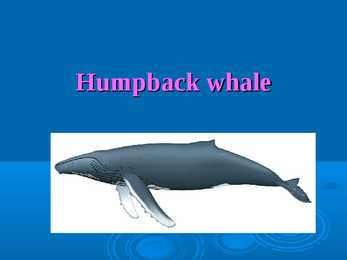
day. Mating and breeding Humpback whales reach sexual maturity at 6- 10 years of age or when males reach the length of 11.6 m and females reach 12 m. Each female typically bears a calf every 2-3 years and the gestation period is 12 months. The calf is between 3-4.5 m long at birth, and weighs up to 907 kg. Distribution and migration Is found in all the world's oceans. Most populations of humpback whales follow a regular migration route. They are summering in temperate and polar waters for feeding. They are wintering in tropical waters for mating and calving. Status Because their feeding, mating, and calving grounds are close to shore and because they are slow swimmers, the humpback whales were an easy target for early whalers. The International Whaling Commission (IWC) gave them worldwide protection status in 1966, but there were large illegal kills by the Soviets until the 1970's. It is believed they number about 30,000-
surges from the North Sea. In 2000, Londonwide government was restored, with the creation of the Greater London Authority. Geography: Greater London covers an area of 607 square miles. Its primary geographical feature is the Thames, a navigable river which crosses the city from the southwest to the east. The Thames Valley is a floodplain surrounded by gently rolling hills including Parliament Hill, Addington Hills, and Primrose Hill. London has a temperate marine climate, like much of the British Isles, so the city rarely sees extremely high or low temperatures. London is a relatively dry city with regular but generally light precipitation throughout the year, with an average of 583.6 millimetres every year.
Latvia Capital city: Riga Total area: 65 000 km² Population: 2.3 million Language: Latvian Latvia, officially The Republic of Latvia, is a country in the Baltic region of the Nothen Europe. The country has a temperate seasonal climate. Latvia and Estonia share a long common history. As a consequence of the Soviet occupation both countries are home to a large number of ethnic Russians (26.9% in Latvia and 25.5% in Estonia). Latvia was found on 18th November 1918. However, its independence was interrupted at the outset of World War II. In 1940, the country was forcibly incorporated into the Soviet Union, invaded and occupied by Nazi Germany in 1941, and re-occupied by the
are the most known are also the two biggest ones.The territory of Estonia covers 45,227 km2. There is 3,794 kilometers of coastline marked by numerous bays, straits, and inlets. The Republic of Estonia is divided into fifteen counties: Hiiumaa, Saaremaa, Läänemaa, Harjumaa, Lääne-Virumaa, Ida-Virumaa, Tartumaa, Jõgevamaa, Järvamaa, Raplamaa, Viljandimaa, Pärnumaa, Valgamaa, Põlvamaa and Võrumaa. The capital city of estonia is Tallinn. Estonia is influenced by a temperate seasonal climate. Estonia has four seasons of near-equal length. July is the warmest month, and February is the coldest month. Snow cover, which is deepest in the south-eastern part of Estonia, usually lasts from mid-December to late March. South-Estonia is the most mountainous part of the country . The country's highest point is the Suur Munamägi. It is 318 meters high. There are some craters in Estonia. The biggest one is Kaali crater in Saaremaa. Estonia has over 1,400 lakes
Island. The South island remained rather peaceful until gold was found there and thousand of people hurried there to look for gold. Since World War , New Zealand has moved towards its own unique national identity and place in the world. New Zealand was the first sovereign state to give votes to women. Weather and climate: New Zealand is in the Southern Hemisphere, which of course means mid summer is at Christmas time while mid winter is June/July. The climate is oceanic temperate. The seasonal variations in New Zealand weather are smaller than continental North America or mainland Europe. North Island has a warm mild climate, almost sub-tropical in the extreme north. Auckland average summer temperature (January) is about 21C and winter is 11C. Annual rainfall in North Island is around 125-150cm, the west receiving slightly more rain than the east. South island is colder. Energy and natural resources:
constitute separate counties: Saaremaa and Hiiumaa. A small, recent cluster of meteorite craters, the largest of which is called Kaali is found on Saaremaa, Estonia. Estonia has over 1,400 lakes. Most are very small, with the largest, Lake Peipus, (Peipsi in Estonian) being 3,555 km2. There are many rivers in the country. The longest of them are Võhandu (162 km), Pärnu (144 km), and Põltsamaa (135 km). Estonia has numerous fens and bogs. Estonia is situated in the northern part of the temperate climate zone. Thanks to the Atlantic Ocean and the Gulf Stream, the impact of the weather in Estonia is much softer then on the same typical latitude of continental climate. Estonia has four seasons of near-equal length. Average temperatures range from 16.3 °C on the Baltic islands to 18.1 °C inland in July, the warmest month, and from -3.5 °C on the Baltic islands to -7.6 °C inland in February, the coldest month. The average annual temperature in Estonia is 5.2 °C
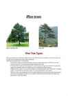
Pine trees Short Leaf Pine Tree Pine Tree Pine Tree Types Pines are among the most well-known coniferous trees in the world. They thrive in temperate mountainous regions, but can also survive in tropical spots in the northern hemisphere. Among the most popular types of Pine trees are: ·Scotch Pine: Commonly found in North America where it is commercially grown as a Christmas tree, the Scotch Pine is known for its beautiful bluish-green needles and full shape. ·Ponderosa Pine: Popular among landscapers, the large Ponderosa can grow up to 80 feet tall. Its pyramidal
and Greek. An Aboriginal language remains the main language for about 50,000 people. Population Its population is around 20 351 000 people and is a rich blend of various ethnic groups, with substantial populations from Italy, Greece, former Yugoslavia, the Far East and Africa. There are 120 000 Aborigines. The density is 2.8 persons per km2. Climate Because of the country's great size, the climate in australia ranges from tropical regions of the Northern Territory to the cool temperate conditions in the southeast and Tasmania, where it often snows in winter. In the north, half the year is wet and half is dry. And its a popular place for winter holidays in the sun. Western has dry, hot, deser climate. Eastern has temperate, wet, and rainfall occurs all year round. Mountains, Rivers and Lakes The Great Barrier Reef, the world's largest coral reef, lies a short distance off the north-east coast and extends for over 2,000 kilometres
and Joy". The melody of our national anthem is the same that of the national anthem of Finland. Estonians hold up their traditions. My country is famous for its Song and Dance festivals which are held in every 4 years. At Christmas, every year we eat the same Christmas food the blood sausage and sauerkraut. The national food of Estonia is kama. It is finely milled flour mixture. In addition, Estonians have also invented Skype. The climate in Estonia is temperate. We are lucky to have 4 seasons. In winter, the minimum temperature is -43,5°C and in summer the maximum temperature is +35,2°C. It is difficult sometimes because Estonians have endure the big changes of temperature. That is why we are so adaptable. The wettest period in Estonia is September and there are many thunderstorms in August. Sometimes the weather is so unpredictable that people cannot plan their oudoor activities. Estonia is small but wonderful country
The aim: To inspire and deliver science-based plant conservation worldwide, enchanging the quality of life. The saying by Kew scientists: "All life depends on plants" Anniversary · 250 this year · Several events: International Garden Photographer of the Year Exhibition, Walking Tours, Scientific Conference, Great Plant Hunt Week Buildings and structures · Glasshouses (Palm House, Alpine House, Evolution House, Temperate House) · Museums and galleries (Japanese Minka, Kew Palace) · Decorative structures (Ice House, Japanese Gateway) · Formal Gardens (Colour Spectrum, Grass Garden, Aquatic Garden) Themed collections · Lilac Garden · Marine Display · Japanese Landscape · Azaba Garden · Bamboo Garden · Mediterranean Garden Wildlife areas · Conservation area · Gravel pit · Lake & surroundings · Biodiversity Garden · Bee Garden
You can see the mouth of the Columbia River and two lighthouses, Cape Disappointment Lighthouse (built 1856) and the North Head, Lighthouse (built 1898). Available activities include camping, picnicking, ocean views, beachcombing claming, surf, jetty and lake fishing, boating and visitation of the Lewis & Clark Interpretive Center · The Hoh Rainforest is located on the Olympic Peninsula in western Washington state, USA. It is one of the largest temperate rainforests in the U.S. · Mount Rainier is a massive stratovolcano located 54 miles (87 km) southeast of Seattle in the state of Washington, United States. North Cascades National Park is a U.S. National Park located in the state of Washington. The park is the largest of the three National Park Service units that comprise the North Cascades National Park Service Complex. Largest cities in Washington State is · Seattle
ENGLAND England is a country that is part of the United Kingdom. It shares land borders with Scotland to the north and Wales to the west; it is surrounded by the Irish Sea, the Celtic Sea, the North Sea and the English Channel, it's linked to Frane by the Channel Tunnel. The total area of the country is more than 130000 sq km. Most of England is lowland, but there are upland regions in the north, south and south west. The climate is temperate, subject to frequent changes, with plentiful rainfall all year round, although the seasons are quite variable in temperature, it rarely falls below -5 or rises above +30 degrees. The longest river, the Severn, flows for 354km. England's capital London, is the largest metropolitan area in the United Kingdom, drawing from a wide range of people, cultures and religions, speaking over 300 different languages, mixing their culture, traditions, music
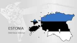
ESTONIA Strelnikova Viktoriya ESTONIA AT A GLANCE • Area: 45 227 square km • Climate: humid-temperate • Number of islands: 1 521. Largest islands are Saaremaa, Hiiumaa and Muhu. • Estonia is a green land, forests cover 55% of the country. • Estonia is a country of thousand of lakes, largest of these are Lake Peipsi and Lake Võrtsjärv. • Highest point: Suur Munamägi (Great Egg Hill), 318 m • The capital of Estonia is Tallinn (439 517 inhabitants (01.01.2016) or approx. 32% of the total population).
after passed the navy. In fact I think it's a plus to Estonia as they will be always ready to defence their freedom with belief that they know what they are doing. Australia, being the world smallest continent but the world sixth-largest country by total area, with its 7.741.220 square kilometres land has only 24 million people. The geography of the country is extremely diverse, ranging from the snow-capped mountains of the Australian Alps to large deserts, tropical and temperate forest. 70% of the Australian mainland is classified as desert which is mainly located in the centre of Australia what explains now the population. When you visit Australia, there aren't many expressions you'll hear more often than "no worries, mate".They are very laid-back, irreverent, funny and happy people. Maybe it's all the sunshine, the miles of beaches, or the pristine nature, or the excellent quality of life but nothing seems to worry them.
containing some of the world's largest islands. Average winter and summer high temperatures across the country vary depending on the location. Winters can be harsh in many regions of the country, particularly in the Prairie provinces, where daily average temperatures are near -15°C (5°F), but can drop below 40°C (40°F) with severe wind chills. Coastal British Columbia is an exception and enjoys a temperate climate with a mild and rainy winter. On the east and west coast average high temperatures are generally in the low 20°C, while between the coasts the average summer high temperature range between 25°C to 30°C with occasional extreme heat in some interior locations exceeding 40°C. Canada's land ranges from fertile agricultural plains in the south to freezing tundras in the north. The southwest of Canada has a mild climate. Cold winters characterize most of the
many forms of music, such as country and roots music in the USA, which in turn have had some influence on modern rock music Irish literature For a comparatively small island, Ireland has made a disproportionately large contribution to world literature. Irish literature encompasses the Irish and English languages. Food and drink Food and cuisine in Ireland takes its influence from the crops grown and animals farmed in the island's temperate climate and from the social and political circumstances of Irish history Sport Gaelic football is the most popular sport in Ireland in terms of match attendance and community involvement, with about 2,600 clubs on the island. In 2003 it represented 34% of total sports attendances at events in Ireland and abroad, followed by hurling at 23%, soccer at 16% and rugby at 8% and the All- Ireland Football final is the most watched event in the sporting calendar
reptile species. About 91,000 insect species have been described. In America, there are very many parks, which 58 are national parks and there are hundreds of federally managed parks, forests and wilderness areas. The first national park in the world was Yellowstone national park in Wyoming. http://www.youtube.com/watch?v=3iaSlZE-Wxs&feature=related Many species became extinct soon after the first settlements. The U.S. climate is temperate in most areas, tropical in Hawaii and southern Florida, polar in Alaska, semiarid in the Great Plains, Mediterranean in coastal California and arid in the Great Basin. The droughts and floods are infrequent in America. In north Alaska was recorded the lowest temperature in U.S. -62.2 °C . The highest temperature was recorded in California in Death Valley when the temperature reached 57 °C. The flora is so diverse in America because of the different climates and
) housing, and governments cut down public housing expenses. Inadequate shelter or housing creates conditions that promote disease. Without decent ( ) protection, many of the poor are exposed ( ) to severe ( ) and dangerous weather as well as to bacteria and viruses carried by other people and animals. They also are more likely to become infected with diseases carried by insects or rodents (). In arid()regions, drought leaves the poor without clean water for drinking or bathing. In temperate climates, including in the major cities of developed countries many of the homeless poor are harmed by or die of exposure ()to extreme winter cold. Inadequate shelter almost always accompanies inadequate sanitation and unhygienic practices. Because the poor in developing nations commonly have no running water or sewage() facilities, human excrement and garbage accumulate, quickly becoming a breeding ground for disease. In cities, especially in
Auckland War Memorial Museum It's a large multi-exhibition museum in the Auckland Domain, known for its impressive neo-classicist style. Eden Park It's the city's primary stadium and a frequent home for All Blacks rugby union and Black Caps cricket matches. It will be the location of the 2011 Rugby World Cup final. 8. What is its nickname? City of Sails, for its enthusiasm for the sport of sailing. 9. Describe the climate of Auckland. Auckland has a warm-temperate climate, with warm, humid summers and mild, damp winters. The average daily maximum temperature is 23.7 °C in February, and 14.5 °C in July. It is one of the sunniest spots in the country. It also has a high rainfall, which ensures the lushness of its rainforests. Summer is from December to February, Autumn or Fall is from March to May, Winter is from June to August, and Spring is from September to November. 10.Why is it easy to travel in A?
Like the US and Canada, Australia was an English speaking colony of Great Britain. Today Australia is a modern developed country with a diversified economy. Australia is an island continent of 7.7 million square kilometres, which makes it a little smaller than the USA. Located in south of Asia, between The Pacific and Indian Oceans, Australia is the World's driest continent. Although large areas of the centre are desert, Australia has a wide range of climate from tropical in the north to temperate in the south east, where it frequently snows in winter. Geographical position The coasts of Australia are surrounded by the Pacific Ocean, the Indian Ocean and the Southern Ocean. Four seas are surrounding Australia, which are the Timor Sea and Arafura Sea in the north of Australia, the Coral Sea in the north-east of Australia and the Tasman Sea, near the island of Tasmania, in the south-east of Australia. Government The full name of the county is the Commonwealth of Australia
temperatures (0 °C) at inland weather stations, but only 10 days at coastal stations. Ireland is sometimes affected by heat waves, most recently 1995, 2003, 2006. Nature Ireland has fewer animal and plant species than either Britain or mainland Europe because it became an island shortly after the end of the last Ice Age, about 8,000 years ago. Many different habitat types are found in Ireland, including farmland, open woodland, temperate broadleaf and mixed forests, conifer plantations, peat bogs, and various coastal habitats. Forest covers about 10% of the country. Only 26 land mammal species are native to Ireland, because it was isolated from Europe by rising sea levels after the Ice Age. Some species, such as the red fox, hedgehog, and badger are very common, whereas others, like the Irish hare, red deer and pine marten are less so. Aquatic wildlife such as
oilseed rape, wheat ● Feeding flocks in the winter may cause significant crop damage ● Less vocal than the noisy whooper and Bewic´s swan ● Can be aggressive in defence of their nests Breeding ● Lay an average of four eggs ● Female broods for 36 days ● The cygnets do not reach the ability of flight before an age of 120 to 150 days Distribution and habitat ● Found naturally mainly in temperate areas of Europe across western Asia ● Partically migratory throughout northern latitudes in Europe and Asia, as far south as north Africa and the Mediterrranean ● Also founded in Iceland Distribution of tundra swan ● Difficult to differentiate ● Breeds in the Arctic, subarctic tundra ● Inhabit – shallow pools, lakes and rivers ● Migratory birds ● The breeding range extends across the coastal lowlands of Siberia to the Pacific
On the South Island there are 18 mountains that are higher than 3000m. The highest mountain is Cook mountain - it's 3754m high. North Island isn't as mountainous as South Island but it's volcanic. The highest mountain there is Ruapehu mountain - it's 2797m high and currently active. The landscape of New Zealand is very popular with making movies and TV- shows - for example the trilogy of "Lord of the Rings" and "The Last Samurai" are filmed there. The climate is temperate all over the country. The temperature rarely goes under 0°C or over 30° in populated areas. The weather on the west coast is moist and cool. In the Mackenzie hollow it turns drier and on the North-Auckland peninsula the climatic zone is almost tropical. The highest temperature in New Zealand taken is 42.2 °C and the lowest -21.6 °C. The driest city in New Zealand is on the South Island and it's named Christchurch
Most of the lakes lie in the volcanic plateu of the North Island and in glacial valleys near the Southern Alps of the South Isaland. On both islands the rivers rise in the mountains and flow down to the sea. The rapid flow of New Zealand's rivers makes them important sources of hydroelectric power. New Zealand has hundreds of waterfalls. Sutherland falls on the South Island is the fifth highest waterfall in he world. New Zealand enjoys a temperate and moist climate, without extremes of heat or cold. Seasons are the reverse of the Northern Hemisphere History A brown-skinned people called Maori were the first people to live in New Zealand. Europeans first visited the country in 1642, but they didn't start to settle on the island until the late 1700''. Today, New Zealanders are descendants of early European settlers who arrived in 1800's. The settlers came mainly from Britain. The country was once part of the British Empire