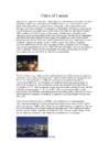
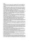
Ottawa Ottawa is the capital of Canada and a municipality within the Province of Ontario. Located in the Ottawa Valley in the eastern portion of Southern Ontario, the city lies on the southern banks of the Ottawa River, a major waterway forming the local boundary between the Provinces of Ontario and Quebec. The 2006 Census recorded the population at 812,129, making it the fourth largest municipality in the country and second largest in Ontario. Connected by several bridges to its Quebec neighbour , the City of Gatineau on
Tallinn English College CANADA Report Karin Kristen Tapupere 8.b Instructor: Tiiu Martma Intro: Canada is a country occupying most of northern North America, extending from the Atlantic Ocean in the east to the Pacific Ocean in the west and northward into the Arctic Ocean. It is the world's second largest country by total area and its common border with the United States to the south and northwest is the longest in the world. The land occupied by Canada was inhabited for millennia by various groups of Aboriginal people. Beginning in the late 15th century, British and French expeditions explored, and later settled along, the Atlantic coast. France ceded nearly all of its colonies in North America in 1763 after the Seven Years' War. In 1867, with the union of three British North American colonies through Confederation, Canada was formed as a federal dominion of four provinces. It is a bilingual and multicultural
Early History The first inhabitants of Canada were native Indian people who were called as Inuits. They are believed to be in Canada since about 10000 BC. The Inuits came to Canada from Asia crossing the Bering land bridge. The earliest discoveries in Canada were made by the Vikings. In AD 985 Vikings sailing from Iceland to Greenland were blown westward off their course and the Vikings sighted the coast of Labrador peninsula. The report of forested areas encouraged further exploration because the colonies in Greenland which belonged to the Vikings lacked lumber. In AD 1000 Leif Ericson became the first European to land in North America. The first colony was established what was described as Vinland by the Vikings.
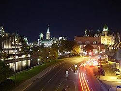
Canada. Canada is a very big country in the continent of North America. It is about 10 million square kilometres and that makes it the second largest country in the world after Russia. Quebec (the province) is six times as big as the UK. Canada borders the Atlantic Ocean, the Pacific Ocean, the Arctic Ocean and the USA. The capital of Canada is Ottawa and other main cities are Toronto, Montreal and Vancouver. It is a very developed country. Montreal is the largest city and it is called the Paris of North America because most of the people there speak French. The population of Canada is 28 million people. It is a very multicultural country. People from many different countries have come to live there. The natives are Eskimos and Indians. Eskimos have their own self-governing homeland called Nunavut
History First people who lived in Canada came by a land bridge from Russia and Greenland. They were the ancestors of nowadays indigenous people of Canada. They just searched better for living places and followed their prey and they didn't even know they were on a different continent. The first explorers were Norse seafarers known as Vikings. As they sailed from Iceland to Greenland in AD 985, they were blown far off their course and they saw the coast what must have been Labrador. The forested areas of Canada's coast encouraged further explorations, because their settlement lacked lumber. They established a colony, what they called Vinland
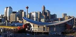
Rocky Mountains. The province extends 1,223 kilometres north to south and 660 kilometres east to west at its maximum width. Its highest point is 3,747 metres at the summit of Mount Columbia in the Rocky Mountains along the southwest border, while its lowest point is 152 metres on the Slave River in Wood Buffalo National Park in the northeast. Alberta contains numerous rivers and lakes used for swimming, water skiing, fishing and a full range of other water sports. There are three large lakes and a multitude of smaller lakes less than 260 square kilometres each. Lesser Slave Lake (1,168 square kilometres) is northwest of Edmonton. The longest river in Alberta is the Athabasca River which travels 1,538 kilometres from the Columbia Icefield in the Rocky Mountains to Lake Athabasca. Edmonton is the most northerly major city in Canada, and serves as a gateway and hub for resource development in northern Canada. Alberta's other major city, Calgary is surrounded by
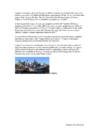
CANADA Geography Canada is the world's second largest country in total area after Russia , since it covers nearly 10 million square kilometres, but is one of the most sparsely populated, with only about 34 million inhabitants. The majority of them live within 300 kilometres of Canada's southern border. Much of the rest of Canada is uninhabited or thinly populated, because the country has a rugged terrain and severe climate. Canada extends across the continent of North America, from Newfoundland on the Atlantic coast to British Columbia on the Pacific coast and northward into the Arctic Ocean. Canada shares land borders with the United States to the south and north-west. Canada is a land of great variety. Towering mountains, crystal-clear lakes, and lush, green forests make Canada's far west a beautiful region. Farther inland, fields of wheat and other grains cover Canada's vast prairies
Table of contents 1. Introduction 2. Geographical position 3. Mountains, lowlands 4. Rivers, lakes 5. The territories and provinces 6. Towns, economy, agriculture 7. Climate 8. Animals, plantlife 9. Population 10. Sports 11. Culture 12. History 13. Political system, symbols 14. Conclusion 15. Materials 1. Introduction If you had to use two words to describe Canada, they might be large and diverse. Canada is the second largest country in the world, bordered by three oceans, and across the country, Canadians experience many different landscapes from rolling plains and mountains to the cold tundra of the north. Despite Canada's great size, it is one of the world's most sparsely populated countries. This fact, coupled with the grandeur of the landscape, has been central to the sense of Canadian national identity. 2. Geographical position Canada is the second largest country in the world after Russia. In the Arctic, Canada


Kõik kommentaarid