Leidsid 33 sarnast õppematerjali, mis on seotud failiga "Metsatüübid". Need materjalid aitavad sul teemat sügavamalt mõista.
forest, forests, metsad, soil, grow, muld, species, birch, pine, moss, ground, layer, alustaimestik, spruce, growth, quality, class, thick, stand, kasvukohatüüp, stands, alder, alusmets, classes, tootlikkus, kase, here, grass, puistud, metres, dominant, lack, typical, tüsedus, glei, peat, kõdu, rich, part, found, sand, bilberry, stock, kuusiku, occurForestry Importance: · Environmental-protective importance Oxygen Cleans the air/soils/ground water Protects the soil from erosion · Timber Firewood Woodwork Building materials Timber cellulose paper · Mushrooms/berries/juices · Habitat of different species Measuring the amount of forest: · Fixing the area under the forests (ha/%) -> In Estonia 47.4%, 2.143 mil/ha It doesn't take into account the amount of timber · To measure the amount of timber (m3) -> 352.7 mil/m3 It doesn't take into account the annual increase · To fix different species of trees (%) -> Pine 40%, Birch 30%, Spruce 20% · To measure the annual increase of timber (m3, ha, year) -> 9 mil. m3/ha/year Main principle of the economy of forests: Annual cutting should be equal to annual increase. Trees are divided into:
Temperate deciduous forests, woodlands and shrub Tartu 2008 Location: Temperate forests are typical of all European continent, the Eastern region of Asia (in special, Chinese and Japan) and North America. Also are finded in tempered areas of South America. Climate: The average temperature in temperate forests is 50° F. Summers are mild, and average about 70° F, while winter temperatures are often well blow freezing. The average yearly precipitation is 30-60 inches. This precipitation falls throughout the year, but in the winter it falls as snow. There are four seasons in this biome, with warm summers and cold winters, often snowy. In autumn, the leaves change color and fall from the trees. The leaves decay on the forest floor, so the soil is very rich.
Savanna A savanna is a grassland ecosystem with scattered trees or shrubs. In savannas trees are small or widely spaced so that the canopy does not close. It is often believed that savannas are characterized by widely spaced, scattered trees, however in many savanna communities tree densities are higher and trees are more regularly spaced than in forest communities. The open canopy allows sufficient light to reach the ground to support an unbroken herbaceous layer consisting primarily of C4 grasses. Savannas are also characterised by seasonal water availability, with the majority of rainfall being confined to one season of the year. Savannas can be associated with several types of biomes. Savannas are frequently seen as a transitional zone, occurring between forest and desert or prairie.
Different types of forests and their forms of usage TARTU 2010 Forest A forest (also called a wood, woodland, wold, weald, holt, frith) is an area with a high density of trees. Forests cover approximately 30% of land and 9.4% of all the planet earth. They are also responsible for regulating our planet's climate and act as large purifiers of airs, by absorbing carbon dioxide, and giving out oxygen. Different types of forests Forests are divided into following main types: o Tropical forest o Subtropical forest o Plantations o Boreal forest o Temperate forest o Seasonal or monsoon forest Tropical and Subtropical Forests Tropical and subtropical forests, also known as rainforests or tropical rainforests, are lavish and ample forests with broad leave tree. They are mostly found at lowlands near the equator - Asia, Africa, South & Central America and on many of the Pacific Islands
2. Where is prairie, pampas, steppe, and veldt situated? EurasiaSteppe, North America-Prairie, South AmericaPampa, South AfricaVeldt 3. Using the climate diagram describe the climate of the region. Temperate deciduous forest -Well-defined seasons with a distinct winter characterize this forest biome. Moderate climate and a growing season of 140-200 days during 4-6 frost-free months distinguish temperate forests. Temperature varies from -15° C to 25° C. Precipitation (750-1500 mm) is distributed evenly throughout the year. Temperate grassland- Semiarid, continental climates of the middle latitudes typically have between 25 cm and 50 cm of precipitation a year. Much of this falls as snow, serving as reservoir of moisture for the beginning of the growing season. Warm to hot summers are experienced, depending on latitude. In the winter, grassland temperatures can be as low as
TARTU VEERIKU KOOL New Guinea animals and plants Koostaja: Tauri-Viljar Vahesaar Juhendaja: Priit Pensa Tartu 2009 Table of content Introduction................................................................................................................................................3 The forests of New Guinea .......................................................................................................................5 The problem with trading wildlife.....................................................................................................6 Animals of the lowlands....................................................................................................................8 Reptiles...................................................................
How to produce bioenergy from agricultural resources without harming the environment Jürgen Aosaar Jaak-Albert Metsoja Ahto Oja BOVA cource on biogas from biomass March 3-7 2008 Tartu Deciduous tree species on abandoned agricultural land Current situation • The long term development plan of the Estonian energy industry foresees a reduction in the use of fossil fuels and an increase in the share of biofuels: by the year 2010 renewable energy must account for 5.1% of total energy consumption Current situation (2) • In Estonia we have abandoned arable land about 400 000 ha, part of it is overgrowing naturally, and another part has been afforested
There are six large areas of temperate grassland: the Pampas in South America, the Veld in Africa, the Canterbury Plains in New Zealand, the Murray-Darling Basin in Australia, the Prairies in North America and the Steppes in Central Asia. 2. Colour the distribution of temperate grassland on the map. 3. How is temperate grassland called in these regions? Eurasia - steppe Hungary - puzda North America - prarie South America - pampa South Africa - veldt 4. What is forest steppe (forest steppe – metsastepp)? A forest steppe is a temperate-climate ecotone and habitat type composed of grassland interspersed with areas of woodland or forest. 5. Describe the climate of temperate grassland. Temperate grasslands have a temperate continental climate, which is cooler than savannas. Temperate grasslands have warm, humid summers with an average temperature of 18° C and cool, dry winters with an average temperature of 10° C. Most of the rain falls as
Canada is a vast country, with a territory of 3.8 million square miles of land and fresh water it is the second biggest country in the world after Russia. Canada covers most of the northern part of North America. Canada has over 151,480 miles of coastline. Most of Canada's human population lives along its southern border. 3. Relief Canada's geography is very diverse. It has huge lakes, evergreen forests, prairies, meadows and beautiful mountains. There are thousands of miles of coastline with beaches, fjords and wild rivers flowing to the oceans. Canada is a country of wide open spaces and beautiful landscape where traveling visitors can unexpectedly bump into wild animals like bears or be struck by unusual sight like the scarecrows on the Cabot Trail. Canada is rich in natural
Tundra Tundra is the world's youngest biome. It was formed 10 000 years ago. Located at latitudes 55° to 70° North. Almost all tundras are located in the Northern Hemisphere, encircling arctic desert and extending south to the coniferous forests of the taiga. The ecotone (ecological boundary region) between the tundra and the forest is known as the tree line or timberline. Tundra comes from the Finnish word tunturi, meaning treeless plain. It is noted for its frost-moulded landscapes, extremely low temperatures, little precipitation, poor nutrients, and short growing seasons. Dead organic material functions as a nutrient pool. The two major nutrients are nitrogen and phosphorus
Rainfall is distributed throughout the year with the heaviest rainfall in August. Nature Waterbodies Estonia is a country of thousands of lakes. There are about 1450 natural and man-made lakes in Estonia. The two largest of them are Lake Peipsi (the fifth largest in Europe; 3 555 sq km, shared with Russia) and Võrtsjärv (270 sq. km). Of all the other lakes, only 45 have an area of more than 100 ha. Lake Peipsi and Lake Võrtsjärv are rich in fish. In Lake Peipsi you can find rare species of fish such as the lake whitefish and the Peipsi smelt. Võrtsjärv is famous for its catches of pike-perch and eel, which are regarded as a delicacy. Estonia has more than 7 000 rivers, streams and drainage ditches. Only nine are over 100 km in length. The longest, at 162 km, is the Võhandu River in the southeast, followed by the Pärnu, Põltsamaa and Pedja rivers. Forests Forest covers around one half of Estonia. The most common types of tree are pine, spruce and birch
Estonian University of Life Sciences Report on Soil Microflora By Katrin Vares Tartu 2013 Introduction The purpose of this report is to define soil microflora and establish the importance of it. Since the microorganisms clearly play an important role in preserving the balance of life, the next objective is to look into factors that influence this balance. Natural conditions and cultural impact could be considered as the variables that correlate the most with the activity and composition of microflora, hence some of the natural and cultural factors will be looked into a little more in detail.
The best time to visit England is from May to September. July and August are the hottest months, but unfortunately the wettest too. In September and October the temperatures drop slightly. January and February are the coldest months and there's often snow on highland areas, especially in Scotland. Plants The mild climate, plenty of rain and a long growing season in Britain support a great variety of plants, which grow exceptionally well. Most of Britain was once covered with thick deciduous forests in which oak trees predominated. The impact of centuries of dense human population has massively altered the flora of Britain and only small parts of those forests remain today. Although about 10 percent of Britain is still forested, most of this area consists of commercially planted coniferous forests in Wales. Before they were affected by the people, the oak forests spread over the best soils of Britain
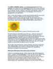
The sunflower (Helianthus annuus) is an annual(iga aastane) plant in the family Asteraceae, with a large flower head (inflorescence(õiekobar, õisik, õitseaeg, õidumine)). The stem(tüvi) of the flower can grow up to 3 metres tall, with the flower head reaching 30 cm in diameter. The term "sunflower" is also used to refer(nimetama, viitama, üle andma) to all plants of the genus(perekond, sugu) Helianthus, many of which are perennial(alaline, aastaringne) plants. What is usually called the flower is actually a head (formally(ametlikult) composite(liit-, komposiit- ; korvõieline, komposiit) flower) of numerous flowers (florets) crowded(täistuubitud, tunglev, rahvarohke) together
Eastern England the most extreme. Annual rainfall is fairly evenly distributed but the amount of precipitation varies greatly between the mountainous areas of the west and the central and eastern parts. 7. Animals, plants Animals The diversity of animals is modest because of several factors: the size of the land area, seasonal changes and the age of habitats on the island. Because GB has a small area, it means that the number of species that can evolve is limited because there is not enough land mass to support the diversity of animals. The environment is very young due to the Ice Age, so there has not been enough time for such diversity to develop. The seasonal changes that occur across the country mean that the animals have less to eat. Since industrialization began in England in the mid eighteenth century, it has had a big impact on indigenous animal populations. Song
Finland is a country of thousands of lakes and islands; 187,888 lakes (larger than 500 m²) and 179,584 islands to be precise. One of these lakes, Saimaa, is the fifth largest in Europe. The Finnish landscape is mostly flat with few hills and its highest point, the Halti at 1,324 metres, is found in the extreme north of Lapland at the border between Finland and Norway. The landscape is covered mostly (seventy-five percent of land area) by coniferous taiga forests and fens, with little arable land. The most common type of rock is granite. It is a ubiquitous part of the scenery, visible wherever there is no soil cover. Moraine or till is the most common type of soil, covered by a thin layer of humus of biological origin. The greater part of the islands are found in southwest in the Archipelago Sea, part of the archipelago of the Åland Islands, and along the southern coast in the Gulf of Finland.
Canada is a vast country, with a territory of 3.8 million square miles of land and fresh water it is the second biggest country in the world after Russia. Canada covers most of the northern part of North America. Canada has over 151,480 miles of coastline. Most of Canada's human population lives along its southern border. Geographical facts. Canada's geography is very diverse. It has huge lakes, evergreen forests, prairies, meadows and beautiful mountains. There are thousands of miles of coastline with beaches, fjords and wild rivers flowing to the oceans. Canada is a country of wide open spaces and beautiful landscape where traveling visitors can unexpectedly bump into wild animals like bears or be struck by unusual sight like the scarecrows on the Cabot Trail. Canada is rich in natural wonders, one of them, the Niagara Falls between lakes Erie and
The island of Tasmania is in the south-east of Australia. The capital of Tasmania is Hobart. The seas and oceans that wash the coasts of Australia are warm. The Coral Sea is the warmest that is why many corals live in the seas. The skeletons of these tiny organisms have formed a great belt of coral- called the Great Barrier Reef. Its is 2000 km long and 2-150 km wide. There are five distinguishable natural zones in Australia. In the very east there are wet forests that occupy the space between the Great Dividing Range and the eastern coast. The wet forests give place to beautiful grasslands with some trees called the savannas. Farther west the trees disappear and the bushlands begin. The real desert occupies the centre of the Western Plateau. In the very southwest there are thin forests of evergreen trees. Most of Australian trees are kinds of eucalyptus (or gum tree to Australians) and acacia (wattle of Australians)
of the world's most important denudations of Ordovician sedimentary rocks. The glint rises to its highest point (56m) at Ontika. Estonia has over 1,500 islands. The largest of them are Saaremaa, Hiiumaa, Muhu and Vormsi. There are over 1,400 lakes in Estonia, biggest being Lake Peipsi and Lake Võrtsjärv, while the deepest is Rõuge Suurjärv. The two longest rivers are the Võhandu and the Pärnu and the widest is Emajõgi. About 50% of the country is covered by forests while wetlands cover 30%. The landscape of Estonia, through covering a small area, is varied and unique. Lake Peipsi is Estonia's largest lake and Europe's fourth largest freshwater lake. 5. Symbols The flag The Estonian blue-black and white national flag was originally the flag of the Estonian Students' Society and was consecrated in Otepää Church in 1884. Today there is a memorial plaque on the church wall commemorating the event.
become increasingly aware of the problems that surround it. With a massive influx of natural disasters people need to be aware of what types of environmental problems our planet is facing. Current environmental problems make us vulnerable to disasters and tragedies, now and in the future. Unless we address the various issues seriously we are surely doomed for disaster. Current environmental problems require urgent attention. 1. Pollution: Pollution of air, water and soil require millions of years to recoup. Industry and motor vehicle exhaust are the number one pollutants. Heavy metals, nitrates and plastic are toxins responsible for pollution. While water pollution is caused by oil spill, acid rain, urban runoff; air pollution is caused by various gases and toxins released by industries and factories and burning of fossil fuels; soil pollution is majorly caused by industrial waste that deprives soil from essential nutrients.
majority of the year. Climate sculpts the landscape through heat, cold, humidity, light and wind. In Canada, the variety of landscapes shows the diversity of our climate. In the north, low precipitation and cold temperatures favour permafrost and suppress vegetation growth, resulting in treeless tundra. South of the tundra, on the Canadian Shield, summers are short and warm, and winters are long and cold. Annual precipitation is abundant, allowing coniferous forests to establish and grow. On the Pacific coast, the combination of heavy rainfall and mild temperatures year round supports Canada, Kärt Kalvet 8a temperate rain forests. On the Prairies, the large number of days of sunshine affects the development of the agricultural landscape. In the Maritimes, the Atlantic Ocean moderates the climate such that winters are generally long and mild, and summers are short and cool. These conditions help in the development of forests. Finally, around the Great Lakes and alongside the
an island but rather small for a continent. Australia is 1,800 miles from the mainland of Asia and almost half way round the world from Europe. More than 6,000 miles of ocean separate in from the America. Australia is the only continent except for Antarctica that lies all south of the equator. The natural zones of Australia are very various. There are deserts, semi deserts, grasslands, savannas, bushlands and rainforests. The wet forests occupy the narrow region in the east. Most of the animals, birds and insects live in that region, because there is enough food. The savannas which are grasslands with some trees are mostly in the west. Farther west are the bushlands. The real deserts occupy the centre of the Western Plateau. In the very south west there are thin forests of evergreens trees. Australia is the driest inhabited continent, the flattest, and has the oldest and least fertile soils.
ref. to presence of fatty acids changing pH; ref. to ionic bonds breaking (in soluble lipase); ora AVP; e.g. ref to industrial uses ref to effect on R groups max 4 [5] 14. (a) starts with previously uncolonised area / bare ground / bare rock / AW; ref to pioneer species / named pioneer; series of recognisable, seres / stages; progresses to, climax / final equilibrium stage; max 2 (b) stabilise environment; soil development / increase humus / organic material; change soil pH; hold more water; release more minerals or nutrients / increase N content or fix N / hold ions;
The unofficial anthem of Australia is `Waltzing Matilda'. It tells a story about a swagman, who has named his sleeping blanket Matilda. He is chased by police for stealing a sheep which he wanted to eat. The swagman doesn't want to be punished, so he jumps into a billabong and drowns. The golden wattle was proclaimed the official national floral emblem in 1988. It is a spreading shrub or a small tree, which grows in the under storey of open forest, woodland and open scrub in South Australia, Victoria, New South Wales and the Australian Capital Territory. Green and gold were proclaimed Australia's national colour by the Governor-General in 1984. Before the proclamation, Australia had no official colour, although three colour combinations traditionally had a claim to be Australia's national colours: red, white and blue; blue and gold; and green and gold. Head of State:
Droughts are followed by floods. Australia has three time zones. In Western Australia is equal to Greenwich Mean Time plus 8 hours. In New South Wales, Victoria, Queensland, and Tasmania and in Australian Capital Territory time is equal to Greenwich Mean Time plus 10 hours. In South Australia, Northern Territory, Broken Hill, NSW time is equal to Greenwich Mean Time plus 9 ½ hours. Plants A rich variety of plants can be found in the natural landscapes of Australia. A lot of species can be found in wet tropical forests in the north and in temperate rainforests in the south. The biggest family of native plants is the myrtles. They include more than 500 species of eucalyptus, or gum trees. Only the big river red gum is seen nearly everywhere. These can be found beside rivers and dry riverbeds. Some gum trees are valuable timber species and have been cut down for many years. Gum tree leaves are full of oils, which evaporate easily.
Each has its own provincial or territorial symbols. The major difference between a Canadian province and a territory is that a province receives relatively greater power and authority. The youngest of the territories and provinces is Nunavut, created from the east portion of The Northwest territories. 6. Towns, economy, agriculture The two largest cities in Canada are Montreal and Toronto, however, the capital is Ottawa. Canada's vast forests have made it the world's largest producer of pulpwood for making paper. The country also has enormous mineral reserves, especially of oil and iron, which have helped make Canada one of the ten leading industrial nations of the world. Canada is one of the few developed nations that is a net exporter of energy. Canada has vast deposits of natural gas on the east coast and large oil and gas resources centred in Alberta, and also present in neighbouring British Columbia and Saskatchewan
Most of them are short. The Murray River with its tributary the Darling gives water for irrigation (vilja kastmiseks). Most of the lakes also have water only after the rains. Lake Eyre, the biggest, is one of the many salt lakes in Central Australia. Australia has much underground water. The Great Artesian Basin under the Central Lowlands makes cattle-breeding possible there. The network of artesian wells provides cattle with water. Natural zones. The wet forests occupy the narrow coastal region in the east. In the west they give place to grasslands with some trees called savannas. Farther west the trees disappear and the savannas give place to the bushlands. The real desert occupies the centre of the Western Plateau. In the very south-west there are thin forests of evergreen trees. Most of the Australian trees are various kinds of eucalyptus (gum tree) and acacia (wattle). Some eucalyptuses are small bushes in the semideserts, some are the
very low content of lactate soluble potassium account for 40 - 65 %. Considerable phosphorus deficit occurs in 20 - 35 % of soils in the arable area. The soils of Põlva, Valga and Võru counties are exceedingly poor in humus. The available water supply in the metric profile of arable soils at the beginning of vegetation period varies from 140 to 255 mm. Gleyic and gley soils occupy the large areas in the West-Estonian depression, in the Peipus Lowland and Hiiumaa. In cental Estonia soil conditions are relatively favourable for agricultural production. On the other hand in the north and south - east of Estonia and on the islands occupy less - fertile soils. In drawing up plans of development and planning land use local self - goverments should take account of concrete natural conditions more than before. Also, more attention should be given to alternative possibilities of land use. Key words: soils, texture, water-supplying capacity, fertility Sissejuhatus
Parque Nacional), 12 natural parks (Portuguese: Parque Natural), nine natural reserves (Portuguese: Reserva Natural), five natural monuments (Portuguese: Monumento Natural), and seven protected landscapes (Portuguese: Paisagem Protegida), which include the Parque Nacional da Peneda-Gerês, the Parque Natural da Serra da Estrela and the Paul de Arzila. These natural environments are shaped by diverse flora, and include widespread species of pine (especially the Pinus pinaster and Pinus pinea species), the chestnut (Castanea sativa), the cork-oak (Quercus suber), the holm oak (Quercus ilex), the Portuguese oak (Quercus faginea), and eucalyptus (Eucalyptus globulus). All are prized for their economic value. Laurisilva is a unique type of subtropical rainforest found in few areas of Europe and the world: in the Azores, and in particular on the island of Madeira, there are large forests of
Handbook of Meat Processing Handbook of Meat Processing Fidel Toldrá EDITOR A John Wiley & Sons, Inc., Publication Edition first published 2010 © 2010 Blackwell Publishing Blackwell Publishing was acquired by John Wiley & Sons in February 2007. Blackwell’s publishing program has been merged with Wiley’s global Scientific, Technical, and Medical business to form Wiley-Blackwell. Editorial Office 2121 State Avenue, Ames, Iowa 50014-8300, USA For details of our global editorial offices, for customer services, and for information about how to apply for permission to reuse the copyright material in this book, please see our website at www.wiley.com/ wiley-blackwell. Authorization to photocopy items for internal or personal use, or the internal or personal use of specific clients, is granted by Blackwell Publishing, provided that the base fee is paid directly to the Copyright Clearance Center, 222 Rosewood Drive, Danvers, MA 01923. F
solar energy, calm days mean no wind blows to drive wind turbines, droughts reduce water availability to produce hydroelectricity). The production and use of renewable fuels has grown more quickly in recent years due to higher prices for oil and natural gas, and a number of State and Federal Government incentives, including the Energy Policy Acts of 2002 and 2005. The use of renewable fuels is expected to continue to grow over the next 30 years, although we will still rely on non-renewable fuels to meet most of our energy needs. 3.3 How Do We Measure Renewable Energy? 15 Each of the energy sources we use is measured, purchased, and sold in a different form. Many units of measurement are used to measure the energy we use. Learn more about converting energy units in the Units of Measurement section. NONRENEWABLE ENERGY
centuries, mutation produced a wide array of colours based on 2 different pigments. Eumelanin gives the blacks, browns and blues while phaeomelanin gives the reds, fawns and creams. A few other genes give further variations on those colours such silvers, colourpoints and solids/selfs. Mutations continue to occur and unexpected colours also turn up due to inbreeding where recessive genes, hidden for generations, start showing up. AMBER AND LIGHT AMBER During the 1990s, some purebred Norwegian Forest Cats in Sweden produced chocolate/lilac and cinnamon/fawn offspring. However, those colours are not found in the purebred Norwegian Forest Cat gene pool. Had the gene pool become polluted by someone, perhaps generations ago, breeding their Norwegian Forest Cat to another breed? Was it a spontaneous mutation? Crossing of those cats with known chocolate and cinnamon colour cats of other breeds ruled out chocolate/lilac and cinnamon/fawn genes. These cats were a totally new
Games Programming with Java and Java 3D Andrew Davison Dept. of Computer Engineering Prince of Songkla University HatYai, Songkhla 90112 E-mail: [email protected] Draft: 14th January 2003, #2 Abstract This article looks at the advantages and disadvantages of using Java and Java 3D for games programming. It assumes the reader is familiar with Java, but presents short overviews of gaming, the low-level APIs OpenGL and DirectX, and Java 3D. No programming examples are included here, although links to online code are supplied. 1. Background to Gaming Giving a definition for `computer game' is problematic, due to the wide range of game types. For example, the ArcadePod site (http://www.arcadePod.com) divides its hundreds of Java games into more than ten categories: 3D games, multiplayer, action