Acid Rain Report Compiler: Teisi Timma 8a Teacher: Esther Linask Tartu 2009 Acid Rain Acid rain is rain consisting of water droplets that are unusually acidic because of atmospheric pollution - most notably the excessive amounts of sulfur and nitrogen released by cars and industrial processes. Acid rain is also called acid deposition because this term includes other forms of acidic precipitation such as snow. Acidic deposition occurs in two ways: wet and dry. Wet deposition is any form of precipitation that removes acids from the atmosphere and deposits them on the Earth's surface. Dry deposition polluting particles and gases stick to the ground via dust and smoke in the absence of precipitation. This form of deposition is dangerous however because precipitation can eventually wash pollutants into streams, lakes, and rivers.
MIINA HÄRMA GYMNASIUM Deserts Saudi-Arabia Tartu 2007 Deserts In geography, a desert is a landscape form or region that receives very little precipitation. Generally, deserts are defined as areas that receive an average annual precipitation of less than 250 mm (10 inches). Deserts cover at least one-fourth of the Earth's land surface. Desert biomes can be classified according to several characteristics. There are four major types of deserts: · Hot and dry · Semiarid · Coastal · Cold Location The four major North American deserts of hot and dry deserts are the Chihuahuan, Sonoran, Mojave and Great Basin. Others outside the U.S. include the Southern Asian
production, distribution and consumption of fossil fuels and as a by-product from cement production. 4.The two main sources of methane pollution are agriculture and fossil fuel use. 5.Volcanic aerosols are not included to the list because of their episodic nature. 6.The world's oceans absorb more than 80% of heat. 7.The total 20th-century rise is estimated to be 0.17 [0.12 to 0.22] m. 8.Arctic has seen twice the increase of global temperature rate. 9.Increased precipitation has been observed in eastern parts of North and South America, northern Europe and northern and central Asia. 10.Decreased precipitation has been observed in the Sahel, the Mediterranean, southern Africa and parts of southern Asia. 11.There is no clear trend in the annual numbers of tropical cyclones. 12.Antarctic sea ice extent continues to show inter annual variability and localized changes but no statistically significant average trends. 13
It was formed 10 000 years ago. Located at latitudes 55° to 70° North. Almost all tundras are located in the Northern Hemisphere, encircling arctic desert and extending south to the coniferous forests of the taiga. The ecotone (ecological boundary region) between the tundra and the forest is known as the tree line or timberline. Tundra comes from the Finnish word tunturi, meaning treeless plain. It is noted for its frost-moulded landscapes, extremely low temperatures, little precipitation, poor nutrients, and short growing seasons. Dead organic material functions as a nutrient pool. The two major nutrients are nitrogen and phosphorus. Nitrogen is created by biological fixation, and phosphorus is created by precipitation. The most distinctive characteristic of tundra soil is its permafrost, a permanently frozen layer of ground. The average winter temperature is -28°C, but the average summer temperature is 3-16°C. During the brief
Environmental problems: acid rain Elza Lutt 10.a What is acid rain? • Acid rain is a rain or any other form of precipitation(sademed) that is unusually acidic, meaning that it has elevated levels of hydrogen ions (low pH). What is it caused by? Wet deposition- niisked sademed Consequences of acid rains • forests, freshwaters(mageveekogud) and soils • Kills insect and aquatic life-forms • Paint peels off from buildings etc. • Corrosion(söövitus) of steel structures • human health What can be done to decrease acid rains • curbing the release of the
Temperate deciduous forests, woodlands and shrub Tartu 2008 Location: Temperate forests are typical of all European continent, the Eastern region of Asia (in special, Chinese and Japan) and North America. Also are finded in tempered areas of South America. Climate: The average temperature in temperate forests is 50° F. Summers are mild, and average about 70° F, while winter temperatures are often well blow freezing. The average yearly precipitation is 30-60 inches. This precipitation falls throughout the year, but in the winter it falls as snow. There are four seasons in this biome, with warm summers and cold winters, often snowy. In autumn, the leaves change color and fall from the trees. The leaves decay on the forest floor, so the soil is very rich. Because of this, and because of the long growing season, many deciduous forests have been cut down for farming purposes. Plants: Trees of this biome include hardwoods such as maple, oak, hickory, and beech. There are often
2. Where is prairie, pampas, steppe, and veldt situated? EurasiaSteppe, North America-Prairie, South AmericaPampa, South AfricaVeldt 3. Using the climate diagram describe the climate of the region. Temperate deciduous forest -Well-defined seasons with a distinct winter characterize this forest biome. Moderate climate and a growing season of 140-200 days during 4-6 frost-free months distinguish temperate forests. Temperature varies from -15° C to 25° C. Precipitation (750-1500 mm) is distributed evenly throughout the year. Temperate grassland- Semiarid, continental climates of the middle latitudes typically have between 25 cm and 50 cm of precipitation a year. Much of this falls as snow, serving as reservoir of moisture for the beginning of the growing season. Warm to hot summers are experienced, depending on latitude. In the winter, grassland temperatures can be as low as -40° C, and in the summer it can be as high 20° C
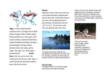
Examples of plants in the taiga biome steppes. The taiga is the world's largest are Siberian Spruce, The taiga experiences relatively low terrestrial biome. Boreal Balsam Fir and Jack precipitation throughout the year (200750 Pine. forest is the term used to refer to the mm annually), primarily as rain during the summer months, but also as fog and snow. southern part of this biome, while "taiga" is used to describe the more barren northern areas of the Arctic tree line. Flora & Fauna
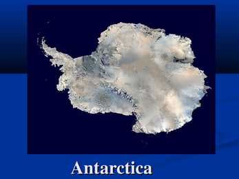
icecovered is about 13,720,000 km² that means about 98% of Antarctica is covered by ice. Climate of Antarctica Antarctica is the coldest, driest and windiest continent, and has the highest average elevation of all the continents. The coldest natural temperature ever recorded on Earth was -89.2 °C at the Russian Vostok Station in Antarctica on 21 July 1983. Antarctica is also extremely dry, technically a desert, whit an average of only 166 mm of precipitation per year. Population of Antarctica The number of people conducting and supporting scientific research. The number of people varies about 1,000 humans in winter and to about 5,000 humans un the summer. Many of the stations are staffed yearround, the overwintering personnel typically arriving from their home countries for a oneyear assignment. Emilio Marcos Palma was thr first person born on the Antarctic mainland in 1978. Geography of Antarctica
20. Äikesetorm- thunderstorm 21. Ilm on lühiajaline aga kliima pikaajaline- weather is short term and climate is long term 22. Mereline kliima- maritine climate 23. Vahemereline kliima- merreterreian climate 24. Kaugus merest- distance from the sea 25. Võimutsevad tuuled merelt- prevailing winds 26. Õhu tihedus sõltub kõrgusest- air density depends on altidude 27. Ookeanihoovused- ocean currents 28. Õhurõhk- air preassure 29. Sademed- precipitation 30. Vesi aurustub ja muutub veeauruks- water vapowizes and turnis into vapour 31. Küllastunud veeaur- saturated vapour 32. Udune ja pilvine ilm- foggy and cloudy weather 33. Libe ja tuuline ilm- slippery and windy weather 34. Pikselöök ja kõuemürin- lightning and thunder 35. Linn on täis sudu ja õhk on väga niiske- city is full of smog and air is very humid 36. Tuul puhub Vaikselt Ookeanilt- wind blows from Pacific ocean
almost every year they exceed 30 °C on some days. The record high temperature in London was recorded on the 10th August 2003 when 39 °C was recorded. Winters in London are chilly, but rarely below freezing with daytime highs around 8 °C - 12 °C, while spring has mild days and cool evenings. The highest temperature ever recorded in London was 39 °C in August 2003. The lowest ever recorded temperature is -10 °C London has regular but generally light precipitation throughout the year, with average precipitation of 583.6 millimeters every year. Snow is relatively uncommon, particularly because heat from the urban area can make London up to 5 °C warmer than the surrounding areas in winter. Some snowfall, however, is usually seen up to a few times a year. London is in USDA Hardiness zone 9, and AHS Heat Zone 2.In the second half of the 19th century and the first half of the 20th, London was noted for its dense fogs and smogs .Following the deadly Great
outlined in white that extends to the edges of the flag. Symbols - With elk as the National Animal, purple heather being its National Flower and dipper as its national bird. Size 323,802 square kilometres Population - 4,999,800 Biggest rivers Glomma and Otra Landscape Scandinavia mountains, The rugged coastline, broken by huge fjords and thousands of islands Climate - The southern and western parts of Norway experience more precipitation and have milder winters than the southeastern part. The lowlands around Oslo have the warmest and sunniest summers but also cold weather and snow in wintertime (especially inland). Famous for 19th century, Henrik Ibseni made Norway famous for plays Interesting facts Norway is one of the wealrhiest countries in the world.It is a peacful country with breathtakingly beautiful mountains and fjords.
Its primary geographical feature is the Thames, a navigable river which crosses the city from the southwest to the east. The Thames Valley is a floodplain surrounded by gently rolling hills including Parliament Hill, Addington Hills, and Primrose Hill. London has a temperate marine climate, like much of the British Isles, so the city rarely sees extremely high or low temperatures. London is a relatively dry city with regular but generally light precipitation throughout the year, with an average of 583.6 millimetres every year.
Acid rains Stefani Nimtsuk What is acid rain? Rain or any other form of precipitation that is unusually acidic It can have harmful effects on plants, aquatic animals, and infrastructure through the process of wet deposition Acid rain is caused by emissions of compounds of ammonium, carbon, nitrogen, and sulfur which react with the water molecules in the atmosphere to produce acids History Since the Industrial Revolution, emissions of sulfur dioxide and nitrogen oxides to the atmosphere have increased
Thanks to the Atlantic Ocean and the Gulf Stream, the impact of the weather in Estonia is much softer then on the same typical latitude of continental climate. Estonia has four seasons of near-equal length. Average temperatures range from 16.3 °C on the Baltic islands to 18.1 °C inland in July, the warmest month, and from -3.5 °C on the Baltic islands to -7.6 °C inland in February, the coldest month. The average annual temperature in Estonia is 5.2 °C. The average precipitation in 19611990 ranged from 535 to 727 mm per year. The capital of Estonia is Tallinn, which is also the biggest town in Estonia. Tallinn lies in the north of Estonia. There are 400 387 people living in Tallinn, which 53.7% are Estonians. The second biggest town in Estonia is Tartu which lies in the south of Estonia. There are 101 169 people living in Tartu, which 80% are Estonians. The third biggest town is Narva, which lies
Acid rain is rain or any other form of precipitation that is unusually acidic. It can have harmful effects on plants, aquatic animals, and infrastructure through the process of wet deposition. Acid rain is caused by emissions of compounds of ammonium, carbon, nitrogen, and sulfur which react with the water molecules in the atmosphere to produce acids. Governments have made efforts since the 1970s to reduce the production of sulfuric oxides into the Earth's atmosphere with positive results Since the Industrial Revolution, emissions of sulfur dioxide and nitrogen oxides to the atmosphere have increased.[2][3] In 1852, Robert Angus Smith was the first to show the relationship between acid rain and atmospheric pollution in Manchester, England.[4] Though acidic rain was discovered in 1852, it was not until the late 1960s that scientists began widely observing and studying the phenomenon. The term "acid rain" was generated in 1972. [5] Canadi...
Recreational use of Pärnu river The catchment area of Pärnu river is 6920 km2 (For example Emajõe river drainage area is 9740 km2). The output is 70m3/s, mean altitude above the sea level - 50 m, maximum altitude - 78 m, mean flow 64,4 m3/s and precipitation 700 mm. Main problems are floods, agricultural pollution, pollution from the local communities, drainage system and flood plain grasslands. There is an excessive flooding in spring. The most known is the Soomaa swamplands flooding in april. It is called to be the fifth season. A lot of rich soil are situated near the pärnu river, for example some of the biggest farmlands are situated in the Järva county. 83% of phosphorus and 79% of nitrogen
The Tundra is located near the Arctic region. It is cold and windy as well. The land is permafrost and desert-like. The growing season is 50-60 days and that's why there are plants like mosses and lichens. Typical animals are musk oxen, elks, moose, lemmings, wolves and foxes. The Taiga biome, also known as coniferous forests is located south of the Tundra region. Taigas are the largest biomes on Earth and they are a major source of oxygen. The climate is cold and harsh with low precipitation and a short growing season. The soil is acidic and only deciduous trees can grow there like hemlocks, pines, larches, spruces and firs. Some typical animals are brown bears, foxes, geese, lynxes and moose. Prairies are temperate grasslands which consist of grass plains that are hot in summer and cold in winter. Prairies are made by fires. The soil is rich and precipitation is medium and because of that prairies are used for agriculture. Common agriculture plants are oats, rye, barley
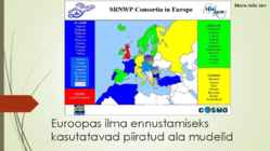
part of Europe. By running the AROME model the main goal is the prediction of small-, or meso-scale (10 – 100 km) weather phenomenon (e.g. thunder-storms, squall-lines, meso-scale convective systems) with high reliability, thus this model is run on a 2.5 km horizontal resolution over the Carpathian-basin. The ALADIN and AROME models provide the expected values of meteorological parameters (pressure, wind, temperature, humidity and precipitation) in the future on a three dimensional grid. The forecast methodology is primarily based on hydrodynamics (or atmospheric dynamics), thermodynamics, radiation theory and cloud-physics . UKMO It is a grid-point model with the ability to run with a rotated pole and variable horizontal grid. A number of sub-grid scale processes are represented, including convection, boundary layer turbulence, radiation, cloud and microphysics. It can be run as a global model, or a limited area
Alaska. The temperature is somewhat moderate considering how far north the area is. The highest and lowest recorded temperatures in Alaska are both in the Interior. The highest is 37.8 °C. The lowest official Alaska temperature is -62.2 ° one degree above the lowest temperature recorded in continental North America. The climate in the extreme north of Alaska is Arctic with long, very cold winters and short, cool summers. Even in July, the average low temperature in Barrow is 1.1 °C. Precipitation is light in this part of Alaska, with many places averaging less than 254 mm per year, mostly as snow which stays on the ground almost the entire year. 5 Pictures 6 7 Used Sources http://en.wikipedia.org/wiki/Alaska http://en.wikipedia.org/wiki/Mount_McKinley 8
latitude. The Baltic Sea causes differences between the climate of coastal and inland areas. The average annual temperature in Estonia is 4.5 degrees Celsius. The average temperature in February, the coldest month of the year, is negative 5.2 degrees Celsius. The average temperature in July, which is considered the warmest month of the year, is 17 degrees Celsius. Estonia is located in a humid zone in which the amount of precipitation outnumbers total evaporation. There are about 160 to 180 rainy days a year, and average precipitation is biggest on the western slopes of the Sakala and Haanja Uplands. Snow cover, which is deepest in the south-eastern part of Estonia, usually lasts from mid-December to late March. Flora and fauna. Estonia is a small country and areas of unspoiled nature are very rare. Our plants and animals have been developing only for 10000 years, since
The average temperature in February, the coldest month of the year, is negative 5.2 degrees Celsius. The average temperature in July, which is considered the warmest month of the year, is 17 degrees Celsius. The climate is also influenced by the Atlantic Ocean, the North- Atlantic Stream and the Icelandic Minimum, which is an area known for the formation of cyclones and where the average air pressure is lower than in neighbouring areas. Estonia is located in a humid zone in which the amount of precipitation outnumbers total evaporation. There are about 160 to 180 rainy days a year, and average precipitation is biggest on the western slopes of the Sakala and Haanja Uplands. Snow cover, which is deepest in the south-eastern part of Estonia, usually lasts from mid-December to late March. Economy of Estonia As a member of the European Union, Estonia is part of the world's largest economic zone
In this region the temperature can climb up to 35 degrees Celsius in the summer and descend to a chilly -25 degrees Celsius during winter. Canada's climate and environment are one of the main reasons that Canada is such a succesful country. The blend of natural resources and climate sustains us. The seasons dictate the look of the land: according to whether the natural environment is in a state of dormancy or growth. Canada's climate is characterized by its diversity, as temperature and precipitation differ depending on where you are and what time of year it is. Other than the North where it's above freezing for only a few months a year, most Canadian cities are within 300 km of the southern border, where mild springs, hot summers and pleasantly crisp autumns are common during the majority of the year. Climate sculpts the landscape through heat, cold, humidity, light and wind. In Canada, the variety of landscapes shows the diversity of our climate. In the north, low precipitation and cold
rainforests are called the 'world's largest "pharmacy"' because of the large amount of natural "medicines" there. o Tourism - People travel both nationally and internationally to experience rainforests firsthand. o Animal products - Rainforests provide numerous animal products including honey, game meat, hides and ivory. o Ecosystem services - Rainforests play an important role in maintaining biological diversity, modulating precipitation infiltration and flooding, increasing scientific knowledge and in the spiritual well-being of humans. Boreal forests Boreal forests are also known by name Taiga. The largest areas of boreal forest are located in Russia and Canada, but also in the extreme northern continental United States, in Eurasia (most of Sweden, Finland, inland Norway), northern Kazakhstan, northern Mongolia and northern Japan. These forests are occupying about 17% of the land and
The growing season is 5060 days and that is why there grow plants such as mosses and lichens. 6. Animals Some typical animals are Arctic foxes, ermines, polar bears, Arctic terns, walruses and seals. Typical tundra animals are musk oxen, elks, moose, lemmings, wolves and foxes. The Taiga biome, also known as coniferous forests is located south of the Tundra region. Taigas are the largest biomes on Earth and they are a major source of oxygen. The climate is cold and harsh with low precipitation and a short growing season. The soil is acidic and only deciduous trees can grow there like hemlocks, pines, larches, spruces and firs. Some typical animals are brown bears, foxes, geese, lynxes and moose. Prairies are temperate grasslands which consist of grass plains that are hot in summer and cold in winter. Prairies are made by fires. The soil is rich and precipitation is medium and because of that prairies are used for agriculture
Acid Rain Acid rain is any precipitation that is unusually acidic. It possesses elevated levels of hydrogen ions(it has low pH level). Acid rain is caused by emissions of carbon dioxide, sulfur dioxide and nitrogen oxides, which react with water molecules. Distilled water(doesn't contain CO 2), has pH level 7. Liquids with pH level less than 7 are acidic, liquids with pH level greater than 7 are alkaline. Unpolluted rain has a pH level over 5.7, so it is slightly acidic. Affected areas
It is permafrost and desert-like. The area is very cold and windy. The growing season is 50-60 days. Some of the plants that can survive there are lichens and mosses. Typical animals for the Tundra are musk oxen, elks, moose, lemmings, wolves and foxes. The Taiga biome, also known as coniferous forests is located south of the Tundra region. Taigas are the largest biomes on Earth and they are a major source of oxygen. The Climate there is cold and harsh. Precipitation is low. The growing season is short. Only deciduous trees can grow there since the soil is acidic. Some typical animals are brown bears, foxes, geese, lynxes and moose. Prairies are temperate grassland. They consist of plains of grass that are hot in the summer and cold in the winter. Prairies are made by fires. The soil is rich and the precipitation is medium. The area has very few trees or shrubs so it is very windy.
Various locations such as 'Hutton's Unconformity' at Siccar Point in Berwickshire and the Moine Thrust in the north west were also important in the development of geological science. Climate of Scotland ! Rainfall totals vary widely across Scotland-- the western highlands of Scotland are one of the wettest places in Europe with annual rainfall up to 4577 mm. Due to the mountainous topography of the western Highlands, this type of precipitation is orographic in nature, with the warm, wet air forced to rise on contact with the mountainous coast, where it consequently cools and condenses, forming clouds. In comparison, much of eastern Scotland receives less than 870 mm annually; lying in the rain shadow of the western uplands.[1] This effect is most pronounced along the coasts of Lothian, Fife, Angus and Eastern Aberdeenshire, as well as around the city of Inverness
River. Almost all the rivers between the mountains flow into the Mississippi. Along the border with Canada, there are five big lakes, called ,,the Geat Lakes". Climate Pacific Ocean moderates west coast temperatures. Mild summers, cool winters, much rain on northwest coast. Warm and dry in summer, mild with some rain rest of the year on California coast. Inland Southwest mostly dry with warm summers and cold winters. Warm summers, cold winters, moderate precipitation on northeast and north-central but warmer. Alaska is extremely cold in winter and has spetacular glaciers. Hawaii is tropical. History Before Columbus came to the New World in 1492, the land were inhabited by Native Americans or Indians. After 1492, there was a struggle for land and domination in the New World. England defeated the Spanish navy in 1588. In 1607, it started its first successful colony in America, called ,,Virginia". That was where Captain John Smith met the beautiful
The Pacific Region The Pacific Region consists of only one province - British Columbia. It is known for its mild coastal climate, forests and the Rocky Mountains. The Rocky Mountains are the youngest and the highest mountains in Canada. Largest cities are Vancouver and Victoria. Only 5% of The Pacific Region is inhabitable. The Prairie Provinces The Prairie Provinces consists of Alberta, Saskatchewan and Manitoba provinces. Population in that region is about 5.7 million people. The precipitation in The Prairie Provinces is very low only 400 mm per year. The biggest cities are Calgary, Winnipeg and Saskatoon. The Prairie Provinces focus on farming. 95% of the land in that region has been converted into farmland. Mostly wheat and other grains are produced. Cattle and sheep ranching is also part of the agriculture. The Prairie Provinces are known for their rolling plains and extreme climate with long, cold winters and hot, dry summers.The region is also rich in oil and natural gas.
· (Keskkonnaabi. Erik Puura. Tartu Ülikool). Kättesaadav 03.02. 2012 http://erikpuura.wordpress.com/2008/01/07/10-maailma-koige-reostatumat-piirkonda/ · (Vikipeedia. Vaba entsüklopeedia). 1. McGraw-Hill Encyclopedia of Science & Technology (10. trükk). McGraw-Hill (2007). Köide 1 (AANO). Lk 6772. ISBN 0071441433 2. Likens, G. E., W. C. Keene, J. M. Miller and J. N. Galloway. 1987. Chemistry of precipitation from a remote, terrestrial site in Australia. J. Geophys. Res. 92(D11):13,299-13,314. 3. Kemling, Melissa. L. (2005). Acid Rain. Entsüklopeedias J. E. Oliver (Toim.), Encyclopedia of World Climatology (Encyclopedia of Earth Sciences Series). Springer. Lk 14. ISBN 1402032641 Kättesaadav 03.02. 2012 http://et.wikipedia.org/wiki/Happesademed · (Bioneer 2009, Katrin Lipp) Kättesaadav 03.02.2012 http://www.bioneer
"JustinTime" (JIT) is a popular strategy used by manufacturing and production companies to improve efficiency in their business. Thus, for stable supply chain and development in the business growth, it is important to understand the causes and effects of bullwhip effect. Implement the business strategies and identify the errors that pull you down in your business; more importantly, analyze the supply chain process, and take the suitable decisions without precipitation, to tackle the demand variations. 9 10 VIIDATUD ALLIKAD De La Fuente, D., Lozano, J. (2005). Application of distributed intelligence to reduce the bullwhip effect. International Journal of Production Research, Vol. 45, No. 8, 15 April 2007, 18151833 Hewitt, F. (2001). After supply chains, think demand pipelines. From the pages of Supply Chain Management Review, 5/1. Kiisler. A. (2011). Logistika ja tarneahela juhtimine. TTÜ Kirjastus
Külmal ei sõltu ööpäevast. Udu Liigid: need on radiatsiooniudu (kohalik teke, jahtumine aluspinna tõttu); advektsiooniudu ei ole kohaliku tekkega, sisserännanud õhumass hakkab jahtuma, talvel suladega; frontaalne udu on haruldane, siis kui on soe front tulemas. Laussadu peab langema läbi jaheda õhukihi ja piisad aurustuvad. Esineb vihmasajuga. Advektiiv-radiatsioonilised udud soe õhk jahedale aluspinnale ja öösel kiirguslik jahtumine. Precipitation fog frontaalne udu. Mais ja juunis on vähe udu, ööd lühikesed, vähe niiskust. Aasta keskmine udupäevade arv. Kagu-eestis ja rannikualadel on vähe, vahe-eestis, lääne-eestis palju. Jäide. Jäitepukk, ladestuse diameeter ilma traadita. Ülemine traat on vahetatav, mõõdetakse ladestuse kaal. Alumist ei puudutata, vaid mõõdetakse diameeter. 90 kraadine nurk traatide vahel on tuulte tõttu. See kaasneb sooja frondiga. Eestis tavaline lühiajaline, mõni tund ja väike, 1-2 mm.
The weather tends to be very changeable as a result of the influences of different air masses. The currents bring warm air in from across the Atlantic. There are few extremes. Southern Britain is warmer than Northern because of its latitude, but in winter the North Atlantic Drift keeps the west milder than the east. Wales and the southern peninsula have the most moderate climate and Eastern England the most extreme. Annual rainfall is fairly evenly distributed but the amount of precipitation varies greatly between the mountainous areas of the west and the central and eastern parts. 7. Animals, plants Animals The diversity of animals is modest because of several factors: the size of the land area, seasonal changes and the age of habitats on the island. Because GB has a small area, it means that the number of species that can evolve is limited because there is not enough land mass to support the diversity of animals. The
..18ºC; in winter, 4...5ºC. Estonian weather offers many surprises. Temperatures may fluctuate by 20º C; in the early morning the thermometer might read 12ºC and by afternoon it may already be 10ºC. Although it doesn't always snow in winter, there tends to be about 10 cm of snow on the ground consistently from late December through to the beginning of March. The sky over Estonia is cloudy for about half the year, and the hilly southeast region experiences up to 750 mm of precipitation due to Estonia's maritime climate. Nature While seven thousand rivers and streams carry rainwater to the sea, bogs and wooded swamplands of different types cover over one fifth of the country -- a world index topped only by the northern neighbour, Finland. Various kinds of forests comprise slightly under half of Estonia's territory. Wetlands, together with primeval forests, represent preserved communities which have for the most part been destroyed in Europe
On the east and west coast, average high temperatures are generally in the low 20s C, while between the coasts the average summer high temperature ranges from 25 to 30 degrees with occasional extreme heat in some interior locations exceeding 40 C. Coastal British Columbia is an exception and enjoys a temperate climate with a mild and rainy winter. Southeastern Canada has a humid climate. The average annual precipitation ranges from about 75 centimetres in southern Ontario to about 150 centimetres on the coast of Newfoundland and Nova Scotia. Canada is a federation of 10 provinces (Newfoundland, Prince Edward Island, Nova Scotia, New Brunswick, Quebec, Ontario, Manitoba, Saskatchewan, Alberta, British Columbia) along with 3 territories (the Yukon Territory, the Nunavut Territory and the Northwest Territories). History
Ireland is the second largest of the British Isles. It´s called the "Emerald Isle" because of its intensive greenery. It´s often visited to see natural beauty and feel relaxed and peaceful. Ireland is known for its pastures and dairy products. Climate Temperate / 'temprt / mõõdukas Ripen / 'rapn / küpsema Prevailing / pr'vel / üldlevinud, ülekaalus olev Dampness / 'dæmpns / niiskus, rõskus Precipitation / prsp'ten / sademed Distribute / d'strbju:t / levitama, jagama The climate is mild and temperate and has an influence on everything. It is influenced by the surrounding seas. The climate is the primary talk subject. In winter there is an average of only an hour or two of sunshine a day. The Weather Wintry / 'wntr / talvine, jäine Set in / set n / algama, võimust võtma Spell / spel / hoog Localised / 'lklazd / paigutama, lokaliseeruma
46 Europe Physical 85 Gross Domestic Product (GDP) .47 Europe Themes Land Use 47 Population Density 86 Climate .48 Gross Domestic Product (GDP) 87 Precipitation .48 Land Use 87 Vegetat ion .49 Climate 88 Environmental Issues: Deforestation, Desertification, Precipitation 88 Acid Rain .49
noticeably from that in the southeastern part. The average in July, which is the warmest month, is about +17 degrees and the coldest month is usually February with 5 degrees as the average. The lowest temperature ever measured is 43,5 ºC and the highest recorded figure is +35,6 ºC. The prevailing winds blow from southwest and west. The windiest place is the isle of Osmussaar. Winds are stronger in autumn and winter. Estonia is located in a humid zone in which the amount of precipitation outnumbers total evaporation. There are about 160 to 180 rainy days a year. Snow cover usually lasts from middle December to late March. Luckily Estonia has no climatic extremes. Heavvy storms and extensive floods are rare. LANDSCAPE Estonia is mostly flat with average elevation of only about 50 meters above sea level. The relief of the present day lanscape was shaped suring the Ice Age. The hilly terrain was also shaped by the continental ice and melting waters
Sir Winston Churchill led Britain through the war, and he was named the architect of the victory. Queen Elizabeth II's coronation in 1953 was the first to be televised. She has three children: Charles (the Prince of Wales), Anne (the Princess Royal) and Andrew (the Duke of York). 5 3) Nature, weather The climate in the British Isles is generally mild and temperate. It is greatly influenced by the surrounding seas. The rainfall and precipitation are huge. You can experience four seasons in the course of a single day. The average temperature is +15...+20 degrees in summer and -5...-7 degrees in winter. The unstable weather has a definite effect upon the national character. They say that it has made the British both cautious and easily adaptable. Great Britain, consisting of England, Scotland and Wales, is 350 miles across at its widest point and 600 miles long at its longest
Põhilised fosforisaaste allikad on kodumajapidamised, tööstused ja aasta-aastalt aina vähem põllumajandus. Ingliskeelsete sõnade tähendused: Plants - taimed Animals loomad Decomporsers - lagundajad Runoff - äravool, ärakanne Phosphate in soil - pinnases olev fosfaat Geological uplifting geoloogiline kerkimine Weathering of phosphate from rocks kivimite murenemisel vabanev fosfaat Leaching- välja imbumine Phosphate in solution lahustunud fosfaat Chemical precipitation keemilised reaktsioonid, sadestumised Detritus settling to bottom sademete põhjasettimine Sedimentation settimine New rock uued kivimid Kasutatud kirjandus. 1) Hergi Karik, Kalle Truus ,,Elementide keemia," Ilo, 2003 2) Hergi Karik ,,Hämmastavad ained," Valgus, 1991 3) Erna Sepp ,,Joogivesi ja meie," Ilo, 2007 4) Sigmar Spauszus ,,Retk anorgaanilise keemia maailma," Valgus, 1971 5) Lembi Tamm ,,Üldine ja anorgaaniline keemia õpik X klaasile," Avita, 2005
world's physical environment. Sea temperatures and levels are projected to rise due to the melting of the polar ice caps and thawing of permafrost, which represents an insidious threat to coastal communities throughout the world. Several diverse extreme weather events, such as droughts, floods, and hurricanes, are occurring concurrently around the world, giving rise to an unprecedented loss of human life and property. Increases in the frequency and intensity of heat waves and precipitation have also been observed. Consequently, a growing number of exotic animals are now on the verge of extinction. More disappointingly, the above- mentioned climatic changes, combined with heedless deforestation and noxious industrial emissions will not only affect animal life by changing important habitats but will also contribute to soil erosion and leaching. Thus, crop yields are expected to continue to drop in coming decades, resulting in widespread famine
This is also a city that has won worldwide acclaim for its forward-thinking, state-of-the- art services. A thriving nightlife has also sprung up in Tallinn, the centre of economic and cultural activity in the country; it's also a hub for major festivals and concerts throughout the year. Tallinn has also been chosen to be Europe's capital of culture in 2011. The climate in Tallinn is characterized by a fairly cold winter, a cool spring with little precipitation, a moderately warm summer and a long and rainy autumn. Other larger cities: Tartu, Narva, Kohtla-Järve, and Pärnu. 14.History People have lived in Estonia since the Stone Age. Various tribes migrated to Estonia and settled in the country after the retreat of the continental glaciers about eleven thousand years ago. The settlement of Estonia is considered to be among the most permanent in the whole of Europe. Estonians resisted the
WEATHER AND CLIMATE The Czech Republic has a temperate continental climate, with relatively hot summers and cold, cloudy and snowy winters. Most rain falls during the summer. The temperature difference between summer and winter is relatively high, due to the landlocked geographical position. Within the Czech Republic, temperatures vary greatly, depending on the elevation. In general, at higher altitudes, the temperatures decrease and precipitation increases. The wettest area in the Czech Republic is found around Bíl Potok in Jizera Mountains and the driest region is the Louny District to the northwest of Prague. Another important factor is the distribution of the mountains; therefore, the climate is quite varied. At the highest peak of Snzka (1,602 m/5,256 ft), the average temperature is only -0.4 °C (31.28 °F), whereas in the lowlands of the South Moravian Region, the average temperature is as high as 10 °C (50 °F)
· Little Pollution As demand for electricity soars, the pollution produced from fossil fuel- burning plants is heading towards dangerous levels. Coal, gas and oil burning power plants are already responsible for half of America's air pollution. Burning coal produces carbon dioxide, which depletes the protection of the ozone. The soft coal, which many power plants burn, contains sulfur When the gaseous byproducts are absorbed in clouds, precipitation becomes sulfuric acid.. Coal also contains radioactive material. A coal-fired power plant emits more radiation into the air than a nuclear power plant. The world's reserves of fossil fuels are running out. The sulfurous coal which many plants use is more polluting than the coal that was previously used. Most of the anthracite, which plants also burn, has been used up. As more soft coal is used, the amount of pollution will increase
Tallinna Arte ja Kristiine Gümnaasium 15 Ingliskeelsete sõnade tähendused: Rain vihm Plants - taimed Animals loomad Decomporsers - lagundajad Runoff - äravool, ärakanne Phosphate in soil - pinnases olev fosfaat Geological uplifting geoloogiline kerkimine Weathering of phosphate from rocks kivimite murenemisel vabanev fosfaat Leaching- välja imbumine Phosphate in solution lahustunud fosfaat Chemical precipitation keemilised reaktsioonid, sadestumised Detritus settling to bottom sademete põhjasettimine Sedimentation settimine New rock uued kivimid KASUTATUD KIRJANDUS 1) Hergi Karik, Kalle Truus ,,Elementide keemia," Ilo, 2003 2) Hergi Karik ,,Hämmastavad ained," Valgus, 1991 3) Erna Sepp ,,Joogivesi ja meie," Ilo, 2007 4) Sigmar Spauszus ,,Retk anorgaanilise keemia maailma," Valgus, 1971
The climate is temperate in most areas, tropical in Hawaii and southern Florida, polar in Alaska, semiarid in the Great Plains west of the 100 th meridian, Mediterranean in coastal California and arid in the Great Basins. Its comparatively generous climate contributed (in part) to the country's rise as a world power, with infrequent severe drought in the major agricultural regions, a general lack of widespread flooding, and a mainly temperate climate that receives adequate precipitation. 6. Animals, plants, agriculture Animals The moose ranges throughout the northern US. In the eastern forests live elks, black bears, deer, foxes, raccoons, skunks and squirrels. Along the coast of the Gulf of Mexico live large and more colorful birds such as pelicans and flamingos. Alligators can also be found there. Bison (buffalo) exists now only in protected areas. In the western areas live elk, deer, bighorn sheep, mountain goats and a small number of brown bears
triggers these several changes, the mechanisms involved, and their relationship and interaction..................................................................................................................................15 Ionization of the air is a natural phenomenon. The ion density varies according to terrestrial and atmospheric conditions: radioactivity, barometric pressure, humidity, season, time of day, air movement, precipitation, altitude, intensity of ultra-violet and cosmic radiations, or air pollution. An ion is a molecule or a small group of molecules that become electrically charged when gaining or losing an electron. The addition of an electron produces a negative ion (-) while loss of an electron converts it to a positive (+) one. Nature provides a delicate balance of ions. The relatively low natural ion levels do not permit systematic evaluation of their biologic properties
Need andmed tõestavad taas vajadust uurida hoolikalt kriminaalset viktimoloogiat, ja samuti teha antiviktiimset õpetustööd noorte hulgas. Meditsiinitöötajate ja politsei eksperthinnangud vägistamise riskirühma vanuse kohta on praktiliselt identne, mis on näha allpool esitatud tabelis 1: Tabel 1. Eri ohvrirühmade risk langeda seksuaalse vägivalla ohvriks. Politsei ja med.töötajate eksperthinnangud. 84 Menashem Amir. (1967). Victim Precipitation. Forcible Rape. The journal of Criminal Law. N.Y.: Criminology, and Policescience, lk 493. 85 ENUT. (2003). Vägistamise defenitsioon. [www.enut.ee/lisa/Helve%20Kase%20ettekanne(2).doc]. 16. Märts 2009 a. 36 POLITSEI MED.TÖÖTAJAD Noored tüdrukud 16 - 18a Alaealised, 15a ja nooremad
located on a water source. Therefore, it wasn't until the technology to transmit electricity over long distances was developed that hydropower became widely used. 11.1 How hydropower works Understanding the water cycle is important to understanding hydropower. In the water cycle: · Solar energy heats water on the surface, causing it to evaporate. · This water vapor condenses into clouds and falls back onto the surface as precipitation. · The water flows through rivers back into the oceans, where it can evaporate and begin the cycle over again. Mechanical energy is derived by directing, harnessing, or channeling moving water. The amount of available energy in moving water is determined by its flow or fall.Swiftly flowing water in a big river, like the Columbia River along the border between Oregon and Washington, carries a great deal of energy in its flow. So, too,with water descending