Leidsid 33 sarnast õppematerjali, mis on seotud failiga "NORTHERN LIGHTS". Need materjalid aitavad sul teemat sügavamalt mõista.
north, northern, light, lights, particles, colour, occur, often, norway, times, polar, regions, southern, along, even, stream, field, find, usual, green, oxygen, between, extend, height, best, class, keila, borealis, related, belt, radius, island, greenland, canada, alaska, siberia, finnmark, other, clear, night, month, while, europe, hardly, than, yearand it is bordered by three oceans: the Arctic, the Pacific and the Atlantic Oceans. The population of Canada is about 31 million people. About 77% of the people live in cities which lie in a band about 100 miles wide above the border of the United States. The capital of Canada is Ottawa. Other large cities are Montreal, Toronto, Vancouver, Winnipeg and Quebec. 2. Geographical position Canada is a huge country in the continent of North America. It is bordered with the Atlantic Ocean in the east, the Pacific Ocean in the west, the United States of America in the south and the Arctic Ocean in the north. Canada is a vast country, with a territory of 3.8 million square miles of land and fresh water it is the second biggest country in the world after Russia. Canada covers most of the northern part of North America. Canada has over 151,480 miles of coastline
2 What Fuels Are Made From Crude Oil?...................................................................60 17.3 How Does Oil Impact The Environment?................................................................60 3 ENERGY STORY Once upon a time, in a town not far away, there was an 8th grader who was afraid of the dark. Her name was Jules. She was also afraid of the quiet, and of the cold. So she always left on the lights, the TV, and stereo even when she had her I-Pod earbuds on. She took lots of very long, hot showers. She never walked anywhere, but got rides from her mom in a big SUV. She couldn't be happy unless she was using all the energy she possibly could for all the stuff around her. Her friend, Les, didn't like to use any energy at all. He walked to school, read books instead of watching TV, played the trumpet instead of Guitar Hero, and turned off the lights anytime he left a room.
cultural diversity of different nations in Canada. All the communities living in the country are encouraged to remember their origins and hold their own ethnic events and national festivals. Cultural diversity makes Canada even more interesting. In spite of this, in recent years there is a strong movement in French-speaking Quebec to become an independent country. There are many different native people throughout Canada like the Crees, Mohawks, Troquois and Sioux. In the north of the country, the Inuit (Eskimos) now have a self-governing homeland called Nunavut, meaning our land. It is over two million square kilometers and it is inhabited by 17,500 Inuits. The national symbol of Canada is the maple leaf. The national tree is the maple. Canada is also the most tolerant societies in the world because only 13% of Canadians say that they would object their children marrying somebody of a different race, compared with 32% in the USA.
In many areas Inuit were required to live in towns by the 1960s. Mythology Malina Malina is the Sun goddess of the Inuit people who live in Greenland. The word "Inuit" means "people." Malina and her brother, the Moon god Anningan, lived together. They got into a terrible fight and Malina spread dirty, black grease all over her brother's face. In fear, she ran as far as she could into the sky and became the Sun. Anningan chased after her and became the Moon. Anningan Anningan often forgets to eat, so he gets thinner as the days go by. Every month, the Moon disappears for three days while Anningan eats. He then returns to chase his sister once again. This eternal chase makes the Sun alternate in the sky with the Moon. Anningan is the name of the Moon god of some of the Inuit people that live in Greenland. The word "Inuit" means "people." Anningan continually chases his sister, Malina, the Sun goddess, across the sky. During this
...................................9 12. References....................................................................................................10 Introduction I chose finland because there are friendly people and beautiful nature. Finland is bigger than Estonia. There lives over 5 milj. people. Finland capital is Helsingi and there lives about 2 milj. people. Highest top is 1328m. Finland is bordersed with Sweden to the west, Russia to the east and Norway to the north. It is the eight largest city in Europe. Most Finns speak Finnish. The second language is Swedish. Finland is rated the sixth most peaceful country in the World. In Finland there are more than 60000 lakes. Capital: Helsinki Area: 338145km2 Population: 5200000 Language: Finnish, Swedish Currency: Euro (EUR)
Tallinna Tööstushariduskeskus Saturn Referaat Tallinn 2014 Sissejuhatus Saturn is one of the most interesting planets in the solar system. It is the sixth planet in the solar system, and is most famous for its stunning array of rings. It is a very easy planet to pick out in the sky because it is one of the brightest lights in the shy. It also has a very faint greenish color that makes it stand out from the rest of the objects in the sky ("Astronomy for Kids"). Saturn is the second largest planet in the solar system, Jupiter being the only planet that is bigger. It also has at least eighteen moons, more than any other planet in the solar system. There have been three voyages to this extraordinary planet, and one is still in process today. The Pioneer II traveled to Saturn in September of 1979, the Voyager missions
.............................................................................. 8 Population and Ethnicity..............................................................................................9 3 Introduction The official name of the country is the United Kingdom. The United Kingdom is an island country. It consists of the island of Great Britain and Northern Ireland. Great Britain can be divided into three parts England, Wales and Scotland. Each of them has their own capital city. Glasgow in Scotland, Cardiff in Wales and London in England. The country is situated in the north-western Europe. The territory of the United Kingdom is about 244,000 square kilometres and about 60 million people live there. The UK contains a number of small islands. The largest islands that belong to the United
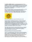
S. state of Kansas, and one of the city flowers of Kitakyushu, Japan. · The Jerusalem artichoke (Helianthus tuberosa) is related to the sunflower. The Mexican sunflower is Tithonia rotundifolia. False sunflower refers to plants of the genus Heliopsis. · Scientific literature reports, from 1567, that a 12 m (40'), traditional, single-head, sunflower plant was grown in Padua. The same seed lot grew almost 8 m (24') at other times and places (e.g. Madrid). Much more recent feats (past score years) of over 8 m (25') have been achieved in both Netherlands and Canada (Ontario). · The sunflower is often used as a symbol of green ideology, much as the red rose is a symbol of socialism or social democracy. Flower formation 1. The first stage of the 3. The flower is nearly flower formation 2. The flower is still covered, completely exposed
and lakes brought together by a beauty spot Halliste primeval valley. According to several folk tales, it is also in these valleys, woods and bogs that Old Nick found refuge.The great variety displayed in the nature is also reflected in the local cultural heritage. At the beginning of the 19th century growing linen spread and became the basis of the legendary wealth of Mulgi farms. The ancient barn-dwellings and decaying manor houses are the mute witnesses of those times. The riches and cultural heritage of Mulgimaa owe to the diligence and tenacity of the local people. Village handicraftsmen and masters have always been honoured. Mulgikapsad (stewed sauerkraut with barley groats), Estonian cheesecakes and kama (a roasted meal-mixture) have not lost their popularity. However, linen growers have now been replaced by cereal grains growers and many farms have specialised on raising sheep or horses. And as the song goes: "Mulgimaa it's a place where life is good
Scotland ! Scotland (Gaelic: Alba) is a country in northwest Europe that occupies the northern third of the island of Great Britain. It is part of the United Kingdom, and shares a land border to the south with England. It is bounded by the North Sea to the east, the Atlantic Ocean to the north and west, and the North Channel and Irish Sea to the southwest. In addition to the mainland, Scotland consists of over 790 islands including the Northern Isles and the Hebrides. Edinburgh, the country's capital and second largest city, is one of Europe's largest financial centres. It was the hub of the Scottish Enlightenment of the 18th century, which saw Scotland become one of the commercial, intellectual and industrial powerhouses of Europe. Scotland's largest city is Glasgow, which was once one of the world's leading industrial metropolises, and now lies at the centre of the Greater Glasgow conurbation which
Their modern-day descendants are generally considered ethnic Germans, Dutch or English.. Saxons participated in the Germanic settlement of Britain during and after the 5th century The Jutes were a Germanic people who were one of the three most powerful Germanic peoples of their time. They are believed to have originated from Jutland in modern Denmark. Were associated with the Saxons. The Jutes, along with some Angles, Saxons and Frisians, sailed across the North Sea to raid and eventually invade Great Britain from the late 4th century onwards, either displacing, absorbing, or destroying the native Celtic peoples there. 6. The Anglo-Saxon invasion Germanic invasions 410-1066 5th cent. A-S soon had the s-east of the country in their grasp. A-S were pagan when they came to br. A-S had little use for towns and cities but had great effect on the countryside, where thay introduced new farming methods and founded thousand self-sufficient villages.
Geography Canada is the world's second largest country in total area after Russia , since it covers nearly 10 million square kilometres, but is one of the most sparsely populated, with only about 34 million inhabitants. The majority of them live within 300 kilometres of Canada's southern border. Much of the rest of Canada is uninhabited or thinly populated, because the country has a rugged terrain and severe climate. Canada extends across the continent of North America, from Newfoundland on the Atlantic coast to British Columbia on the Pacific coast and northward into the Arctic Ocean. Canada shares land borders with the United States to the south and north-west. Canada is a land of great variety. Towering mountains, crystal-clear lakes, and lush, green forests make Canada's far west a beautiful region. Farther inland, fields of wheat and other grains cover Canada's vast prairies
products including honey, game meat, hides and ivory. o Ecosystem services - Rainforests play an important role in maintaining biological diversity, modulating precipitation infiltration and flooding, increasing scientific knowledge and in the spiritual well-being of humans. Boreal forests Boreal forests are also known by name Taiga. The largest areas of boreal forest are located in Russia and Canada, but also in the extreme northern continental United States, in Eurasia (most of Sweden, Finland, inland Norway), northern Kazakhstan, northern Mongolia and northern Japan. These forests are occupying about 17% of the land and make up 27% of the world's forest cover. Temperature in these forests is usually low, as the canopy allows very low sunlight to penetrate. Low penetration of light along with low temperature is responsible for limited under story.
Tallinn English College Topic Great Britain 2007 1. Introduction The official name of Great Britain is `the United Kingdom of Great Britain and Northern Ireland (or short United Kingdom)' The population is about 60.4 million. The capital is London. Other biggest cities include Birmingham, Bristol, Portsmouth, Glasgow and Swansea. English is the main language of Great Britain, but Welsh is officially recognized in Wales and Gaelic in Scotland. 2. Geographical position The British Isles is the geographical term for a group of about 5000 islands off the coast of mainland Europe. The largest island is Great Britain, which is also the largest
for Antarctica that is all on the southern hemisphere. Its name means ,,Southland". The official name of the country is the Commonwealth of Australia. It's capital is Canberra. Australia is the sixth largest country in the world but the smallest continent. Australia has 6 states and 2 territories (New South Wales, Victoria, Tasmania, Queensland, Western Australia , South Australia, The Australian Capital Territory and the Northern Territory). The Australian people are culturally the same as the Anglo Americans. There also live aborigines. Aborigines are the ancestors of the people. Like the US and Canada, Australia was an English speaking colony of Great Britain. Today Australia is a modern developed country with a diversified economy. Australia is an island continent of 7.7 million square kilometres, which makes it a little smaller than the USA.
It was built in the early 1900s just to be the capital. The official language is English and the official name of Australia is the Commonwealth of Australia. Australia is located on the Southern Hemisphere (because of that Australia is also called "A land down under"). 2 . Geographical position Australia is an island continent and it is located between the Indian and South Pacific oceans south east of Asia. From the north it is bordered by the Timor Sea and the Torres Strait. From the east by the Coral Sea and the Tasman Sea. Australia's coastline is about 37,000 km long. The Great Australian Bight washes the southern coast. The Gulf of Carpenteria and the Cape York Peninsula surround it in the south. 3. Relief Australia is the smallest continent in the world It is often called the island continent because is too big for an island but rather small for a continent
Australia Australia is the only country in the world that covers an entire continent, yet also the smallest and the driest of all the continents. It's almost the same size as continental USA, being the sixth largest country in the world. It's also the oldest some of the rocks are more than 3,000 million years old. Australia is often called `Down Under', because it lies in the Southern Hemisphere. As a result, its seasons are the opposite of ours. Australia, Tasmania and a number of smaller islands form the Commonwealth of Australia. Because of the country's great size, the climate in Australia ranges from tropical regions of the Northern Territory to the cool temperate conditions in the southeast and Tasmania, where it often snows in winter. In the north, half the year is `wet' and half is `dry'
Ireland is the third largest island in Europe. It lies in between the Atlantic Ocean and the Irish Sea. Politically it is divided into a sovereign state, the Republic of Ireland, that covers about five-sixths of the island (south, east, west and north-west), and Northern Ireland, which is part of the United Kingdom, covering the northeastern sixth of the island.[1] The name 'Ireland' derives from the name Ériu (in modern Irish, Éire) with the addition of the Germanic word 'land'. The population of the island is just under 6 million (2006); just over 4.2 million in the Republic of Ireland[2] (1.6 million in Greater Dublin[3]) and just over 1.7 million in Northern Ireland[4] (0.6 million in Greater Belfast[5])). Politics Politically, Ireland is divided into:
The temperature rarely rises above 32°C in summer, or falls below -10°C in winter. Summers are generally cool, but due to global warming they are starting to get drier and hotter. Hot weather causes terrible congestion on the roads as Britons rush to the coastal resorts. Winters are generally mild, with the most frequent and prolonged snowfalls in the Scottish Highlands, where it is possible to go skiing. If it does snow heavily in other parts of Britain, the country often comes to a standstill. Trains, buses and planes are late. Contrary to popular opinion, it doesn't rain all the time. There is certainly steady rainfall throughout most of the year, but the months from September to January are the wettest. Thanks to the rain Britain has a richly fertile countryside which is famous for its deep green colour. History The first inhabitants were Iberians and Celts who settled on the land and were often at war with eaeh other
Astronomers had already traced a connection between bursts and supernovas. But this burst was so close, and Swift had spotted it so quickly, that scientists hoped it would help confirm what they suspected: A gamma-ray burst is an exploding star's opening act. After an unusually long flood of gamma rays and x-rays, lasting more than half an hour rather than the typical few seconds, the February 18 burst gave way to visible and infrared light. Within three days this afterglow was fading away--and then the supernova grabbed the spotlight. Astronomers at the Very Large Telescope in northern Chile were watching the afterglow dwindle when they noticed a brightening. The star had exploded just a minute or so after the burst, but most of its energy was invisible ultraviolet and x-ray radiation. Its visible light had brightened more slowly, and now it was finally outshining the afterglow. For the first time, astronomers had
V. Jannsen. It was officially adopted after the War of Independence in 1920.The same melody with different words is also Finland's national anthem. The current coat of arms of Estonia is a golden shield which includes three slim, blue leopards (or lions) in the middle, with oak branches along the side of the shield. It originates from Denmark. It was officially adopted in 1925. Geography Estonia is the northernmost of the three Baltic States. It is located on the northern hemisphere on the eastern shores of the Baltic Sea in the north-east of Europe. It has land contact with Russia from the east and Latvia from the south. In the north The Gulf of Finland separates Estonia from Finland. The Gulf of Riga is situated to the south-west. Estonia has more than 1500 islands. The biggest ones are located to the west. The four biggest islands are Saaremaa, Hiiumaa, Vormsi and Muhu. The highest point in Estonia and also in the Baltic region is Suur Munamägi. It is 318
If you want to make clear that you are speaking about the country, you may call it the Commonwealth of Australia. It’s the official name of the country. Australia is the smallest continent, but one of the largest countries on Earth. It’s 6th largest country. Its area is about 7.6 million sq km. One third of it is occupied by deserts. It’s both the flattest and, except for Antarctica the driest. Neighbouring countries include Indonesia, East Timor and Papua New Guinea in the north, the Solomon Islands, Vanuatu in the northeast, and New Zealand in the southeast. Its capital is Canberra. Other big cities are Melbourne, Sydney, and Brisbane. National language in Australia is English. Monetary unit is Australian dollar. Their national holiday is on the 26th of January. In 1788 on the 26th of January the first fleet arrived at Botany Bay and established a penal colony near modern-day Sydney. Geographical Position Australia is located in the Southern Hemisphere. It’s the
Australia Fact file: Australia comprises a land area of 7 686 850 square kilometres. Its population is about 21,3 million people. Australia's capital is Canberra. The national language is English. The official name of it is the Commonwealth of Australia. It's divided into six states and two territories: New South Wales, Queensland, South Australia, Western Australia, Tasmania, Victoria, Australian Capital Territory (ACT) and Northern Territory. Symbols: Australia had the British flag as their official flag until 1901, when the Commonwealth of Australia was formed. Over 30 000 entries attracted the official competition. Five of them, which contained almost identical designs, were placed equally first. The Australian flag symbolises Australia's historical links with Britain, because it has British flag on it, and Australia's location in the southern hemisphere, because it has stars of the Southern Cross on it
while salt, cloth, herring and wine moved 'in the opposite direction. As salt was an important trading commodity, Tallinn is said to have been built on it. Its geographical position was very favourable, with its wide bay protected by the two outlying islands of Aegna and Naissaar; it proved a suitable place for a large port. By the 12th century there were already six inland trade routes leading to the port, which was often visited by foreign ships. Tallinn developed along three lines: fortress, port and market town. The Lower Town, a free town of merchants and craftsmen, gradually evolved at the foot of Toompea. From the 13th century onwards these became separate towns with different communities, both with their own interests and laws. Tallinn grew rapidly and had developed into a well-known trading centre by the 15th, century. A century later its population of 7,000-8,000 made it one of the
Tallinn 2008 1. Introduction Estonia is a small country about the size of Switzerland, or New Hampshire and Massachussetts combined. Estonia is named after the people called "Ests" who lived in the region in the 1 st century AD. The Republic of Estonia is one of the three countries commonly known as the "Baltic States". The other Baltic States are Latvia and Lithuania. 2. Geographical position Estonia is situated in northeastern Europe. Estonia is bounded on the north by the Gulf of Finland, on the east by Russia, on the south by Latvia and on the west by the Baltic Sea. In the north it borders on Finland. The coastline of the Baltic Sea in Estonia is characterized by numerous gulfs and bays, the biggest of them being the Gulf of Finland, the Gulf of Riga and the Gulf of Pärnu. Bays include the Narva Bay, Matsalu Bay, Kolga Bay, Kunda Bay, Tallinn Bay etc. Estonia has over 1500 islands, the largest being Saaremaa and Hiiumaa, Muhu and Vormsi.
The United Kingdom The United Kingdom consists of England, Scotland, Wales and North Ireland and it is situated in the Atlantic Ocean near the mainland of Europe. The population of the UK is 58.6 million and area is 244,110 sq km. Britain has a temperate humid climate. Its characteristic features are mild winters, warm summer, no temperature extremes, abundant rain all year round and frequent changes of weather. The mild climate is partly due to the warm Gulf Stream and partly to the south westerly winds. Occasional winds from the east in winter may
Estonia. Estonia, officially the Republic of Estonia is a country in Northern Europe. It is the smallest of the three Baltic countries. Estonia has land borders with Latvia (339 km) to the south and Russia (229 km) to the east. It is separated from Finland in the north by the narrow Gulf of Finland and from Sweden in the west by the Baltic Sea. Estonia has been a member of the European Union since May 1, 2004 and of the NATO since March 29, 2004. The area of Estonia is about 45000 square kilometres and the population is about 1.4 million people. The capital of Estonia is Tallinn and the official language is Estonian. The currency is Eesti kroon. The main religion is Lutheran. Anniversary of the republic is celebrated on February 20
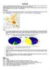
boundaries of Estonia. Not considering Lake Peipsi on the Russian border, it surpasses all other Estonian lakes together by the surface area. The few islands are mostly located in the southern part of the lake. Tondisaar and Pähksaar are permanent islands while Ainsaar turns into a peninsula during low water, and Heinassaar is flooded in high water periods. The shores of Võrtsjarv are mostly low: swampy in the southern part, and sandy in the northern part; the eastern shore is higher. Despite its large surface area, the lake is shallow. The deepest place lies between the eastern shore and the island of Tondisaar along the submerged elongation of the riverbed of the Väike Emajõgi River. The lake depression is of preglacial origin but has somewhat been influenced by glaciers. On the eastern shore the Devonian sandstone bedrock is denuded along a stretch of several kilometres. This abrasion shore at Tamme is 3 - 8 m high and
6. Towns, economy, agriculture 7. Climate 8. Animals, plantlife 9. Population 10. Sports 11. Culture 12. History 13. Political system, symbols 14. Conclusion 15. Materials 1. Introduction If you had to use two words to describe Canada, they might be large and diverse. Canada is the second largest country in the world, bordered by three oceans, and across the country, Canadians experience many different landscapes from rolling plains and mountains to the cold tundra of the north. Despite Canada's great size, it is one of the world's most sparsely populated countries. This fact, coupled with the grandeur of the landscape, has been central to the sense of Canadian national identity. 2. Geographical position Canada is the second largest country in the world after Russia. In the Arctic, Canada reaches almost as far north as Greenland. To the south it extends to the same latitude as southern France. The distance from Canada's west coast, the Pacific Ocean, to its
When humans eat these plants or animals, the toxins inside of the things they eat can affect them. It can cause brain damage, kidney problems and even Alzheimer's disease. The countries that are producing the majority of the pollutions that causes acid rain are not that badly affected (Germany, Britain, USA). Instead the wind direction means the acid rain falls in the other places (in Europe : Scandinavia, USA; Canada) Cultural effects Acid rain and the dry deposition of acidic particles contribute to the corrosion of metals (such as bronze) and the deterioration of paint and stone (such as marble and limestone). These effects significantly reduce the societal value of buildings, bridges, cultural objects (such as statues, monuments, and tombstones), and cars. Famous buildings like the Statue of Liberty in New York, the Taj Mahal in India and St. Paul's Cathedral in London have all been damaged by this sort of air pollution.
The tundra is the world's coldest and driest biomes. The average annual temperature is -28° C. Nights can last for weeks when the sun barely rises during some months in the winter, and the temperature can drop to -70° C. During the summer the sun shines almost 24 hours a day. Summer are usually warm. Average summer temperatures range from 3° to 16°C. TaigaTaiga is the Russian word for forest and is the largest biome in the world. It stretches over Eurasia and North America. The taiga is located near the top of the world, just below the tundra biome. The winters in the taiga are very cold with only snowfall. The summers are warm, rainy, and humid. Some of the animals in the taiga hibernate in the winter, some fly south if they can, while some just cooperate with the environment. GrasslandsGrassland biomes can be found in the middle latitudes. They can have either moist continental climates or dry subtropical climates. There
Australia Australia is the smallest continent in the world. It is 7.6 million square kilometres big. It is often called the island continent because it is rather small for a continent and very big for an island. There are only five countries bigger than Australia in the World. There are five states in the mainland. Tasmania is also considered as a state so there are six states. The Northern Territory and Canberra are also independent but they are not states. Canberra is the capital of Australia and it is situated between Sydney and Melbourne because both of these cities wanted to be the capital. The population is about 19 million people and growing. New South Wales is the most populated state and Victoria is the most densely populated state. The national language is English. It is English because British settlers came to live in Australia in
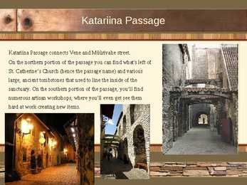
Katariina Passage Katariina Passage connects Vene and Müürivahe street. On the northern portion of the passage you can find what's left of St. Catherine's Church (hence the passage name) and various large, ancient tombstones that used to line the inside of the sanctuary. On the southern portion of the passage, you'll find numerous artisan workshops, where you'll even get see them hard at work creating new items. City wall Tallinn's medieval city wall is a sub-facility that was built