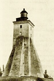
Catherinethal was abandoned by Russian royalty throughout the late 18th and 19th centuries. In the 1930s Konstantin Päts, Estonia's first president, embarked on extensive and controversial restorations with the aim of transforming the park and the palace into his private domain. 5 9. Kõpu Lighthouse Kõpu Lighthouse is one of the best known symbols and tourist sights on the Estonian island of Hiiumaa. It is one of the oldest lighthouses in the world, having been in continuous use since its completion in 1531. The lighthouse is built at the top of the highest hillock of Hiiumaa island, Tornimägi. The lighthouse marks the Hiiu sandbank and warns ships away from the shoreline. The height of the building itself is 36 metres, and the light is 102.6 metres above sea level, making it the highest coastal light on the Baltic Sea. 10. Kaali crater
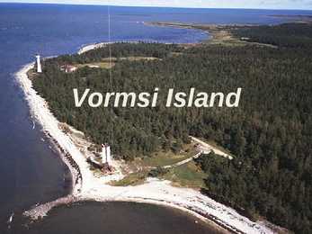
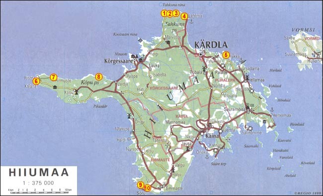
Home to numerous birds and animals . Rich variety of fauna . There are permanent communities of bear, wolf and lynx in the park so keep your camera on standby . It's also home to ... migratory waterfowl ...and swans . In this Park you will see the deep dark pine (mänd) forest . Hiiumaa The second largest island (989 km²) . It is located in the Baltic Sea . The largest town is Kärdla . Hiiumaa is the main island of Hiiu County . Transport From Estonian mainland to Hiiumaa involves a 90minute (28 km) ferry crossing from Rohuküla to Heltermaa . There are about 10 ferry departures a day. In the summer weekends, getting car space on the ferry usually requires advance booking. There are about 2 scheduled buses a day between Tallinn and Kärdla . Hiiumaa is served by Kärdla Airport, with regular flights to Tallinn . Bicycle rental is available in Kärdla and there is a good bicycle path built from Kärdla towards Kõrgessaare . Some pictures ...
Famous places Established in 1919 314m high Orginally based in Kadriorg Palace, but Construction completed has spanned thoughout Estonia in 1980 Geography Mainly a lowland Bordered by the Baltic sea,Latvia & Russia Moderate winters and cool summers Oil shale and limestone deposits Forests covers over 47% of the land Hiiumaa The second largest island Territory: 989 km² In the Baltic Sea, north of the island of Saaremaa Coastline: 310 km Population: 8400 people Kärdla Kõpu Lighthouse One of the best known symbols and tourist sights. One of the oldest lighthouses in the world (1531). At the top of the highest hillock - Tornimägi (English: Tower Hill). Height : 36 meters.
lives and works hand in hand with Latvian Valka the border splits the town in two belonging to different coutries. Otepää is the skiing and winter capital of Estonia, as the area has more snow than any other part of Estonia. WEST ESTONIA West Estonia is low lying and flat. The climate is maritime and greatly influenced by the Baltic Sea. The area features large bogs, extensive forests, coastal plains and a number of offshore islands Saaremaa and Hiiumaa being the largest. The coastal towns, Pärnu and Haapsalu, are Estonia's main seaside resorts. West Estonia includes the counties of Pärnumaa, Läänemaa, Saaremaa and Hiiumaa. Pärnumaa means sun, sea and holidays. It is rich in sandy beaches, forests, bogs and merches. Pärnu is the summer capital of Estonia. Its beach, seaside parks, sanatoriums and rest homes are its characteristic features. The western part of Estonia is flat and low with meadows, forests and swamps
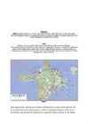
Estonia is bounded on the north by the Gulf of Finland, on the east by Russia, on the south by Latvia and on the west by the Baltic Sea. In the north it borders on Finland. The coastline of the Baltic Sea in Estonia is characterized by numerous gulfs and bays, the biggest of them being the Gulf of Finland, the Gulf of Riga and the Gulf of Pärnu. Bays include the Narva Bay, Matsalu Bay, Kolga Bay, Kunda Bay, Tallinn Bay etc. Estonia has over 1500 islands, the largest being Saaremaa and Hiiumaa, Muhu and Vormsi. Saaremaa and Muhumaa are connected to each other with a bridge. The best- known smalles islands are Naissaar, Aegna, Ruhnu, Kihnu, Väike-Pakri, Suur-Pakri etc. 3. Relief Lying in the north-western part of the East-European Plain, Estonia is mostly flat with an average elevation of about 50 metres above sea level. South-eastern and eastern parts of Estonia are higher than the western parts. The relief of the present-day landscape was shaped during the Ice Age
My Town I live in Tallinn. It's the capital and main seaport of Estonia. Tallinn is a very beautiful city that lies on the Baltic Sea. It covers 158 square kilometres. The Mayor of Tallinn is Jüri Ratas. The population of our capital is about 400000 people. About 55% of them are Estonian, 37% Russians and the other 8% are from different nations. The people here are mostly engaged in industry- mainly the food industry (23%), trade (16%) and transport and communication (14%). History. Tallinn has a great history. It was first marked on a map of the world by the Arab geographer al-Idrisi in 1154, its name then being Kolyvan. In the 13 th- century chronicle of Henricus de Lettis the town was called Lyndanise. Then it was called Reval for some time and finally Estonians started to call the town Tallinn from Taanilinn (Danish town) after the Danish conquest in the 13th century. The Knights of the Sword took Tallinn from the Dane
In these buildings the lifestyle of the times of "Tõde ja Õigus" ("the Truth and the Right") is being exhibited. In the former dwelling house there is an exhibition reflecting the life and creative work of the writer. In summer different events take place; the openair theatre performances are especially popular. From the Museum hiking tracks lead into the countryside of Kõrvemaa. · Kõpu lighthouse is the most famous tourist sight of Hiiumaa, one could even say it is a symbol of the island; it is the third oldest working lighthouse. It is known that in 1490 the Hanseatic League requested the erection of a signal light. The completion date of the building of the lighthouse is considered to be 1531. The light of Kõpu can be seen for 35 nautical miles. It is possible to ascend to the top of the lighthouse.
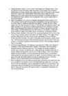
Vormsi Island Location Located between Hiiumaa and the mainland Fourth largest Estonian island Covering 92 square kilometres The meaning of "Vormsi" Known as "snake island" Derived from the German name "Worms" or it's Swedish name "Ormsö", both meaning snake island History Vormsi was inhabited by coastal Swedes 2500 people lived there before WWII During the Soviet occupation Vormsi was a closed border-zone Blend of Soviet and Swedish history mixed with unspoilt nature


Kõik kommentaarid