Leidsid 33 sarnast õppematerjali, mis on seotud failiga "Inglise keele referaat 'Hiiumaa'". Need materjalid aitavad sul teemat sügavamalt mõista.
land, island, light, hiiumaa, swedish, kõpu, part, kärdla, german, dagö, finnish, baltic, although, known, road, ferry, there, metres, kiili, north, germanic, first, between, russian, meaning, coastal, bicycle, built, away, navigation, highest, hill, kairo, located, west, archipelago, county, compare, night, literally, local, evidence, settlement3. Kiek in de Kök tower The cannon tower Kiek in de Kök was founded in 1475-1483. In 1696 the present name Kiek in de Kök was also mentioned, meaning "peek into the kitchen" in Low German. Compared to the other Tallinn towers Kiek in de Kök was predominant in its fire power, due to its 27 embrasures for cannons and 30 for handguns. The floors of the embrasures were initially stepped to
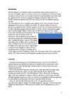
!! Some pictures ... Lahemaa National Park Lahemaa National Park is 70 km east of Tallinn and covers 725 km . The largest . Has a diverse (mitmekülgne) landscape . Home to numerous birds and animals . Rich variety of fauna . There are permanent communities of bear, wolf and lynx in the park so keep your camera on standby . It's also home to ... migratory waterfowl ...and swans . In this Park you will see the deep dark pine (mänd) forest . Hiiumaa The second largest island (989 km²) . It is located in the Baltic Sea . The largest town is Kärdla . Hiiumaa is the main island of Hiiu County . Transport From Estonian mainland to Hiiumaa involves a 90minute (28 km) ferry crossing from Rohuküla to Heltermaa . There are about 10 ferry departures a day. In the summer weekends, getting car space on the ferry usually requires advance booking. There are about 2 scheduled buses a day between Tallinn and Kärdla .
Estonia, Hiiumaa & School Ken Pähn Kärdla Gymnasium 11th grade Estonia Officialy the republic of Estonia Territory: 45 000 sq km Population: 1,3 million Capital: Tallinn 15 counties Language:Estonian Estonian Flag Coat of Arms Blue the blue sky above the native land. Black - the attachment to our black soil. White - hard work and purity. National emblems Barn swallow Corn flower National emblems limestone Estonia President: Toomas Hendrik European Union since 2004 Ilves Nato since 2004 Prime minster: Andrus Ansip United Nation since 1991 Democratic parliamentary republic Andrus Ansip
coastline is approximately 3 800 km. The longest distance from east to west is 350 km, while north to south Estonia stretches 240 km. THE NAME The name EESTI was apparently derived from the word AISTI, the name given by ancient Germans to the peoples living northeast of the Vistula River. Tacitius, the Roman historian, was the first one to mention it (AESTI), while the Arab scholar alIdrisi was the first one to mark it on a map (as ASTLANDA). To the ancient Scandinavians the land was known as EISTLAND; to modern Scandinavians it is known as ESTLAND. Most contemporary languages use the Latin name ESTONIA. FLAG The Estonian blueblackandwhite national flag was originally the flag of the Estonian Student's Society, consecrated in Otepää Church in 1884. today there is a memorial plaque on the church wall commemorating the event. The Flag Museum attracts tourists who take an interest in the history of the flag.
Estonia is bounded on the north by the Gulf of Finland, on the east by Russia, on the south by Latvia and on the west by the Baltic Sea. In the north it borders on Finland. The coastline of the Baltic Sea in Estonia is characterized by numerous gulfs and bays, the biggest of them being the Gulf of Finland, the Gulf of Riga and the Gulf of Pärnu. Bays include the Narva Bay, Matsalu Bay, Kolga Bay, Kunda Bay, Tallinn Bay etc. Estonia has over 1500 islands, the largest being Saaremaa and Hiiumaa, Muhu and Vormsi. Saaremaa and Muhumaa are connected to each other with a bridge. The best- known smalles islands are Naissaar, Aegna, Ruhnu, Kihnu, Väike-Pakri, Suur-Pakri etc. 3. Relief Lying in the north-western part of the East-European Plain, Estonia is mostly flat with an average elevation of about 50 metres above sea level. South-eastern and eastern parts of Estonia are higher than the western parts. The relief of the present-day landscape was shaped during the Ice Age
In the 13 th- century chronicle of Henricus de Lettis the town was called Lyndanise. Then it was called Reval for some time and finally Estonians started to call the town Tallinn from Taanilinn (Danish town) after the Danish conquest in the 13th century. The Knights of the Sword took Tallinn from the Danes in 1227 and made Toompea their fortress. In the middle of the 14th century Denmark sold its possessions in Estonia to the German Teutonic Order; Toompea became the seat of German-born gentry. A fortified wall was built between the Toompea (the Upper Town) and the Lower Town (inhabited by people of a lower social standing), as there were conflicts between the two. The doors and the gates of the wall were locked at night, a procedure which carried on until the end of the 19th century. Tallinn joined the German-dominated Hanseatic League in 1285 and became a
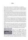
house, barn and farm including a barn, cattleshed and cottagers' buildings. In these buildings the lifestyle of the times of "Tõde ja Õigus" ("the Truth and the Right") is being exhibited. In the former dwelling house there is an exhibition reflecting the life and creative work of the writer. In summer different events take place; the openair theatre performances are especially popular. From the Museum hiking tracks lead into the countryside of Kõrvemaa. · Kõpu lighthouse is the most famous tourist sight of Hiiumaa, one could even say it is a symbol of the island; it is the third oldest working lighthouse. It is known that in 1490 the Hanseatic League requested the erection of a signal light. The completion date of the building of the lighthouse is considered to be 1531. The light of Kõpu can be seen for 35 nautical miles. It is possible to ascend to the top of the lighthouse.
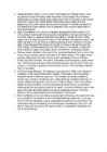
Vormsi Island Location Located between Hiiumaa and the mainland Fourth largest Estonian island Covering 92 square kilometres The meaning of "Vormsi" Known as "snake island" Derived from the German name "Worms" or it's Swedish name "Ormsö", both meaning snake island History Vormsi was inhabited by coastal Swedes 2500 people lived there before WWII During the Soviet occupation Vormsi was a closed border-zone Blend of Soviet and Swedish history mixed with unspoilt nature Nowadays Celtic crosses from the 13th century in Vormsi cemetery Vormsi is for people interested in mixed Soviet and Swedish history and rare nature Landscape Juniper fields Seaside meadows Erratic borders Lighthouses Forests Bays Lagoons To get to Vormsi You have to take a ferry (12 km, 45 min.) from Rohuküla port Public transportation between port and island's centre Hullos
The currency used in Estonia is Eesti kroon. The Estonian national flag is blue-black-white. It was originally the flag of the Estonian Students' Society. The flag was first consecrated in Otepää Church in 1884. For a while, during the Soviet occupation, the flag was banned but it was again seen in public in Tartu in May 1988. The national flower is cornflower, the national bird is barn swallow and the national stone is limestone. The Estonian national anthem called "My Native Land, My Pride and Joy" was composed in 1848 by Friedrich Pacius. The Estonian language words were written by J. V. Jannsen. It was officially adopted after the War of Independence in 1920.The same melody with different words is also Finland's national anthem. The current coat of arms of Estonia is a golden shield which includes three slim, blue leopards (or lions) in the middle, with oak branches along the side of the shield. It originates from Denmark. It was officially adopted in 1925.
Tallinn is the capital and the largest city of Estonia. It lies on the northern coast of Estonia, along the Gulf of Finland. There are 33 cities and several town-parish towns in the country. In total, there are 47 linna, with "linn" in English meaning both "cities" and "towns". More than 70% of the population lives in towns. History • Estonia was settled near the end of the last glacial era, beginning from around 8500 BC. Before the German invasions in the 13th century proto-Estonians of the Ancient Estonia worshipped the spirits of nature. Since the Northern Crusades Estonia became a battleground for centuries where Denmark, Germany, Russia, Sweden and Poland fought their many wars over controlling the important geographical position of the country as a gateway between East and West. Being conquered by Danes and Germans in 1227, Estonia was ruled initially by Denmark in the north, by the Livonian
Estonia Estonia is a small country in Northern Europe with an area of about 45 000 sq km. As a part of the East-European Plain, the country has a rather flat surface. The highest and most diverse region in Estonia is in the south-eastern part of the country. At 318 metres, Suur Munamägi is not only the highest point in Estonia, but of all the Baltic countries. There are about 1500 islands in Estonia, the biggest of which being Saaremaa and Hiiumaa. Sixty-four species of mammals have been recorded in Estonia, three of them have been introduced: the racoon dog, the American mink and the muskrat. A couple of species have been re-introduced The European beaver, who was hunted to extinction by the end of the 19th century. A vital population of them now exists in Estonia once again. Another re- introduced species is the red deer. An attempt has been made in Estonia in recent years to disperse the population of wolves,
Russian Empire. Life changed for the better thanks to the opening of a railway line from St. Petersburg to Tallinn in 1870. Tallinn grew into a major port and an industrial centre, with huge shipyards. Interest in culture grew and Estonians became conscious of their national identity, dreams of independence gained ground. On 24 February 1918 Estonia was declared an independent country and Tallinn became the capital of the Republic of Estonia. During World War II Estonia was occupied by both German and Russian invaders and Tallinn suffered heavily. The bombing of the city by the Soviet air force on 9 March 1944 left over 20,000 people homeless. During the Russian occupation which followed attempts were made to Russify the local people. Estonia re-established its independence on 20 August 1991. Toompea Toompea is the oldest and the most respectable part of the city. For centuries there was only one means of access to Toompea Pikk Jalg Street. In the middle of the 15th
The Danes, led by King Valdemar II, conquered northern Estonia in 1219. Legend has it that one day, when the Danes were about to lose a bloody battle, the sky suddenly opened and a red flag with a white cross on it dropped down upon them from the heavens. This is allegedly how the Danes obtained their national flag, the Dannebrog in a battle against the Estonians. In the middle of the 14th century Denmark sold its possessions in Estonia to the German Teutonic Order. Toompea became the seat of the German-born gentry. A wall was built to separate the Upper Town and the Lower Town. In 1285 Tallinn joined the Hanseatic league and became a junction of trade between East and West. Tallinn is said to be built on salt, as it was an important trading commodity. In the 16th century Tallinn had a population of about 7,000 8,000 making it one of the biggest cities in northern Europe. In 1629 Sweden took control of the whole of Estonia
Project ESTONIA MAP OF ESTONIA Southern Viljandimaa The southern part of Viljandi county catches the eye with its sublime scenery. The area today lies in the very heart of the historical Mulgimaa the home of hills, deep valleys and lakes brought together by a beauty spot Halliste primeval valley. According to several folk tales, it is also in these valleys, woods and bogs that Old Nick found refuge.The great variety displayed in the nature is also reflected in the local cultural heritage
Estonia. Estonia, officially the Republic of Estonia is a country in Northern Europe. It is the smallest of the three Baltic countries. Estonia has land borders with Latvia (339 km) to the south and Russia (229 km) to the east. It is separated from Finland in the north by the narrow Gulf of Finland and from Sweden in the west by the Baltic Sea. Estonia has been a member of the European Union since May 1, 2004 and of the NATO since March 29, 2004. The area of Estonia is about 45000 square kilometres and the population is about 1.4 million people. The capital of Estonia is Tallinn and the official language is Estonian
.........................................10 Introduction I chose finland because there are friendly people and beautiful nature. Finland is bigger than Estonia. There lives over 5 milj. people. Finland capital is Helsingi and there lives about 2 milj. people. Highest top is 1328m. Finland is bordersed with Sweden to the west, Russia to the east and Norway to the north. It is the eight largest city in Europe. Most Finns speak Finnish. The second language is Swedish. Finland is rated the sixth most peaceful country in the World. In Finland there are more than 60000 lakes. Capital: Helsinki Area: 338145km2 Population: 5200000 Language: Finnish, Swedish Currency: Euro (EUR) Goverment: Parliamentary republic President: Tarja Halonen
the east by Lake Peipus and Russia. Across the Baltic Sea lies Sweden in the west and Finland in the north. The territory of Estonia covers 45,227 km 2, and is influenced by a humid continental climate. The Estonians are a Finnic people, and the official language, Estonian, is a Finno-Ugric language closely related to Finnish, and distantly to Hungarian and to the Sami languages. The population of Estonia is 1.5 million. Of this number 62 per cent are Estonians. The geography of the land is surprisingly varied. Islands make up 9,2 per cent of Estonian’s total territory, the largest islands are Saaremaa, Hiiumaa and Vormsi. The highest point is Suur Munamägi, which is 317m high. Estonia has a surprisingly mild climate for an area so far north. Sea winds keep the weather from becoming very cold or hot. Estonia’s flag has three horizontal stripes. The blue stripe at the top of the flag represents the sky. The middle stripe of black stands for the land
Topic Estonia, Tallinn The Republic of Estonia is the northernmost of the three Baltic States on the eastern shore of the Baltic Sea. To the east Estonia borders on Russia and Lake Peipsi and on the south on Latvia. The area of Estonia is 45 100km2, its coastline is 774km long. The geography of the land is surprisingly varied. Islands make up 9,2 per cent of Estonian's total territory, the largest islands are Saaremaa, Hiiumaa and Vormsi. The highest point is Suur Munamägi, which is 317m high. Estonia has a surprisingly mild climate for an area so far north. Sea winds keep the weather from becoming very cold or hot. The population of Estonia is 1.5 million. Of this number 62 per cent are Estonians. Estonians speak the Estonian language, which is closely related to Finnish. Estonia's flag has three horizontal stripes. The blue stripe at the top of the flag represents the sky
But, alas, the lord of the manor's son discovers the deception. He is overcome by jealous rage and orders his men to seal the girl inside the thick stone walls while still alive. Turned into an incarnation of undying love, the White Lady now appears every August, on the night of the full moon, in the Dome Church chapel window. Haapsalu is seven-and-a- quarter centuries old this year, and the townsfolk intend to make it a celebration to remember. The annual dance and light show dedicated to the Lady alone involves over 100 performers - and you'll have several chances to catch it over the four days of the event. Musical shows, dances and contests of strength and skill will be held all over town. This festival is held in August and it is said that Haapsalu, Estonia's most famous ghost, appears during this festival Black nights film festival http://www.tourism.tallinn.ee/fpage/events/newwinprint/ Beerfestival ( Õllesummer)
Its geographic coordinates are 59 North 26 Eeast. Estonias capital is Tallin, it is situated in the North of Estonia. Estonias mainland terrain is flat, boggy, and partly wooded, offshore lie more than 1,500 islands. From the north flat and from the east is Estonia hilly. It's highest peak is Suur Munamägi(318 m). Sometimes flooding occurs in the spring in Estonia. It's biggest lakes are Lake Peipsi and Lake Võrtsjärv. It's biggest islands are Saaremaa and Hiiumaa. In Estonia there is 26.5% arable land, 0.35% permanent crops and 73.15% other land. Natural resources in Estonai are oil shale, peat, phosphorite, clay, limestone, sand, dolomite, arable land, sea mud. The population of Estonia is about 1,341,000 people. Estonia, as a new member of the World Trade Organization, is steadily moving toward a modern market economy with increasing ties to the West, including the pegging of its currency to the euro.
was put on the world map of the Almoravid by cartographer Muhammad al-Idrisi who described it as a small town like a large castle among the towns of Astlanda. It has been suggested that the Quwri in Astlanda may have denoted the predecessor town of today's Tallinn. The earliest name Kolyvan may be derived from the mythical Estonian hero Kalev. Up to the 13th century the Scandinavians and Henry of Livonia in his chronicle called the town Lindanisa: Lyndanisse in Danish, Lindanäs in Swedish, also mentioned as Ledenets in Old East Slavic. According to some theories the name derived from mythical Linda, the wife of Kalev and the mother of Kalevipoeg. who in an Estonian legend carried rocks to her husband's grave that formed the Toompea hill. It has been also suggested that in the context the meaning of linda in the archaic Estonian language, that is similar to lidna in Votic, had the same meaning as linna or linn later on meaning a castle or town in English
Estonia lies on the eastern shores of the Baltic Sea on the level northwestern part of the rising east European platform. Estonia is a flat country covering 46 226 square kilometers.Estonian's neighbours are Finland, Sweden, Latvia and Russia. Estonia is rich in islands. The two largest are Saaremaa and Hiiumaa . Saaremaa is famous for its big meteorite crater called Kaali and Hiiumaa is famous for its nature and plants. The countries highest point Big Egg hill ( Suur- Munamägi) reaches 318 meters above sea level. Estonia has many uplands too. The uplands are: Pandivere upland, Otepää upland, Vooremaa upland, Karula upland Haanja upland, Sakala upland. Estonia is covered by about 18 000 square kilometers of forest. Estonia is also rich in lakes and rivers The largest lake is Peipsi and the second-largest lake is Võrtsjärv
The territory of Estonia covers 45,227 km² and is influenced by a temperate seasonal climate. The Estonians are a Finnic people closely related to the Finns, with the Estonian language sharing many similarities to Finnish. The modern name of Estonia is thought to originate from the Roman historian Tacitus, who in his book Germania (ca. AD 98) described a people called the Aestii. Similarly, ancient Scandinavian sagas refer to a land called Eistland, close to the German term Estland for the country. Early Latin and other ancient versions of the name are Estia and Hestia. Until the late 1930s, the name was often written as Esthonia in most English speaking countries. Estonia is a democratic parliamentary republic and is divided into fifteen counties. The capital and largest city is Tallinn. With a population of only 1.4 million, it is one of the least-populous members of the European Union. Estonia was a member of the League of Nations from 22
Names of town ● Lindanise - it was first used in 1219, derived from mythical Linda, the wife of Kalev and the mother of Kalevipoeg, national hero. ● Koluvan - found in old Russian chronicles, the name possibly deriving from the Estonian mythical hero Kalev ● Reval - used after 1219; comes from two german words ‘reh’ and ‘fall’, meaning the falling of the deer - as they fall down the Toompea hill, probably when escaping from the Danish occupation or just the hunters. ● Tallinn - used after Estonia gained its independence in 1918, origin is definitely estonian; meaning Taani-linn, tali- linn. Liberty Square ● The central square of Tallinn, it was renovated in 2008. There used to be Harju gate, which can now be seen through glass.
Estonia is a small country in Northern Europe with an area of about 45 000 sq km. The country's climate is determined by the proximity of the Atlantic Ocean. The summer temperatures are a little lower than the average of that latitude, but the winters are considerably warmer. As a part of the East-European Plain, the country has a rather flat surface. The highest and most topographically variagated region in Estonia is in the south-eastern part of the country. The Sakala Upland plains offer contrast to the hills of Ottepää, Karula and Haanja. At 318 metres, Suur Munamägi ('Great Egg Hill') is not only the highest point in Estonia, but of all the Baltic countries. The country has 3974 km of coastline, while the land border, in comparison, is only a mere 633 km. The coast varies from limestone cliff in the north to sandy beaches in the west. Most of Estonia's many islands belong to the West Estonian archipelago. The largest islands
Ireland is the third largest island in Europe. It lies in between the Atlantic Ocean and the Irish Sea. Politically it is divided into a sovereign state, the Republic of Ireland, that covers about five-sixths of the island (south, east, west and north-west), and Northern Ireland, which is part of the United Kingdom, covering the northeastern sixth of the island.[1] The name 'Ireland' derives from the name Ériu (in modern Irish, Éire) with the addition of the Germanic word 'land'. The population of the island is just under 6 million (2006); just over 4.2 million in the Republic of Ireland[2] (1.6 million in Greater Dublin[3]) and just over 1.7 million in Northern Ireland[4] (0.6 million in Greater Belfast[5])). Politics Politically, Ireland is divided into: · The Republic of Ireland, with its capital Dublin.
established the relationships between Estonia, Livonia and the Russian Empire. The Baltic Landesstaat reached its full development. The freedom of action in the new provinces was naturally granted to one of the most firm ideological pillars of the tsarist empire -- the Russian orthodox church; though as the Landeskirche in the Estonian and Livonian territories, the Lutheran church long maintained a de facto predominance. The most important organ of Baltic German local government was the Diet, consisting of all the noble families who had been `selected' in a list of the eligible. Although jealously guarding their privileges, the knighthoods still never became entirely closed. Between sessions of a Diet, the legislative power of the knighthoods belonged to the Council of the Diet. The towns were governed by the Town Councils, which supplemented their ranks from among the representatives of merchants and lawyers. The
3 months, could apply to the Magistracy for citizenship. Serfs could escape from serdom after having successfully hidden in town for a year and a day. Two parts remained separated until the end of the 19th century. Four Names Lyndanise - mentioned by Henricus de Lettis in his Chronicle; derives from the name Linda - the wife of Kalev and mother of Kalevipoeg Koluvan - mentioned in Russian chronicles; derives from the hero Kalev from our national epic Reval - comes from the German words “REH” and “FALL”, meaning the falling of the deer; could be deers trying to escape from the Danes, running down the Toompea hill Tallinn - the word origins from estonian language, could mean “taani-linn”, “tali-linn” or “talu- linn”; Reval was replaced when Estonia became independent Symbols Flag - blue black white tricolor; blue represents sky, black the soil, and white our freedom. Danneborg - red flag with a white cross fell from the sky during the battle in 1219
Headland / 'hedlnd / neem Scour / 'ska / küürima Foreshore / 'f:: / tõusu ja mõõna vaheline rand Recreational / rekr'enl / lõõgastumis-, vabaaja- Scenery / 'si:nr / maastik Juxtaposition / dkstpz'in / kõrvuti asetsev GB consists of England, Scotland and Wales. GB is only a dot on the world map. It offers a great variety and scenic contrasts are often within easy reach. The coastline is washed by the tidal system twice a day. Britain´s speciality is the man-made scenery. Each part of the country has its peculiar geographical features. England Indented / n'dentd / sakiline Estuary / 'estjr / suudmelaht Watershed / 'w:td /veelahe Pike / pak / haug Rugged / 'rgd / konarlik, karm
Topic Australia Tallinn English College 2006 Australia 1 . Introduction The name Australia is derived from the Latin Australis, meaning of the south. In land area, Australia is the sixth largest nation, its territory is 7,686,850 sq km and its population reaches today over 20,5 million people. It is the only nation to govern an entire continent and its outlying islands. Australia's capital is Canberra, the only city with its own territory. It was built in the early 1900s just to be the capital. The official language is English and the official name of Australia is the Commonwealth of Australia.
Tallinn Tallinn is situated on the southern coast of the Gulf of Finland, in north-western Estonia. A limestone cliff runs through the city. It is exposed, for instance, at Toompea and Lasnamäe. However, Toompea is not a part of the cliff, but a separate hill. Coastline is 46 kilometres long.The highest point of Tallinn, at 64 meters above the sea level, is situated in the district of Nõmme, in the south-west of the city. The first human steps, that archeologists found, are about 5000 years old. Tallinn`s first fortress was built in Toompea, in 1050. As an important port for trade between Russia and Scandinavia, it became a target for the expansion of the Teutonic Knights and the Kingdom of Denmark
On account of the country's proximity to the sea, the skies are often cloudy, and rain often falls in the spring and autumn, in the winter the rain turns to snow. The highest point in Estonia is Suur Munamäg It is in fact the highest point in the Baltic region Forest cover over one half of Estonia. The most common types of tree are pine, spruce and birch. Estonia, along with Finland and Sweden are the countries with the greatest percentage of forested land. Forest management and wood production are particularly important for the Estonian economy. One third of Estonian forests are protected areas. In these protected forests you can come across types of primeval forest cover, which have long ago disappeared from other parts of Europe. Examples of such primeval forests are the Järvselja forest in Tartumaa County and Poruni in Ida- Virumaa County. Meadows in Estonia are rich in different species much more so than in Western Europe.
Finnish-Estonian writer. She came from Finland and then started writing in Estonian. She has later said that her problem was that she was trying to fix Estonia's problems, although it wasn't something she should have done as she originally was Finnish. She was really scandalous because she published her diaries. In her diaries she wrote about really personal things that most people would never let anyone else read if it were their life. She is also important because she wrote a lot about Hiiumaa. In a matter of fact she also lived on our island, Hiiumaa. One of her stories that talks about Hiiumaa is Hundimõrsija (The Wolf's bride). It's a werewolf story about 17th century Hiiumaa. The story is rich with archaic, romantic, colourful prose. She was also given an Estonian Red Cross Merit Medal. She was always considered as a smart woman. She also wrote Lydia Koidula's biography. Thanks to her we know a lot about Hiiumaa's history and nature.