The climate in Estonia As in other northern countries, seasons varie widely in Estonia. The length of the longest day in summer is over 19 hours, while the shortest winter day lasts only 6 hours. It is not completely dark at night from the beginning of May until the end of July. Estonia, on the coast of the Baltic Sea, is at the same latitude in Europe as central Sweden and the northern tip of Scotland. In North America, the middle latitude of Estonia passes through the Labrador peninsula and southern coast of Alaska. However, due to the influence of the Atlantic Ocean and Gulf Stream, the weather in Estonia is considerably milder than the continental climate characteristic of the same latitude. The temperature in the summer months (June September) is typically 15ºC...18ºC and in winter 4ºC...5ºC. Estonian weather offers many surprises. Temperatures may fluctuate by 20ºC. In the early morning the
longitudes 11° and 5° W. It is separated from the neighbouring island of Great Britain by the Irish Sea and the North Channel. • A ring of coastal mountains surround low plains at the centre of the island. climate The climate of Ireland can be summed up as being mild, moist and changeable with abundant rainfall and a lack of temperature extremes. The country receives generally warm summers and mild winters, and is considerably warmer than other areas on its latitude. This is due to the fact it lies in the Atlantic Ocean, and as a result is warmed by the Gulf Stream all year. tourist attractions Smarmore Castle Benburb Castle The National Galle ry of Ireland World Heritage Sites in Ireland Brú na Bóinne Giant's Causeway Skellig Michael County Meath County Antrim County Kerry The end!
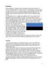
Estonia also boasts numerous bogs, and 3794 kilometers of coastline marked by numerous bays, straits, and inlets. The number of islands and islets is estimated at some 1,500. Two are large enough to constitute their own counties: Saaremaa and Hiiumaa. Estonia lies in the northern part of the temperate climate zone and in the transition zone between maritime and continental climate. Because Estonia is continuously warmed by the Gulf Stream it has a milder climate despite its northern latitude. The Baltic Sea causes differences between the climate of coastal and inland areas. The average annual temperature in Estonia is 5 °C. The average temperature in February, the coldest month of the year, is -5.2 °C. The average temperature in July, which is considered the warmest month of the year, is 18 °C. The climate is also influenced by the Atlantic Ocean, the North- Atlantic Stream and the Icelandic Minimum, which is an area known for the
Form 10A 2009 Introduction The climate is cyclical England is in the middle latitude The English weather changes frequently 52% of the year is overcast England is washed by the warm Gulf Stream Spring March, April, May Wild areas may still be cold and muddy Animals start emerging from their hibernation Plants start blooming Sun and showers Summer Plants and animals start breeding Warm weathers The landscapes are covered with flowers Warm rain The average temperature ranges from 10 0C 150C Britain's highest temperature recorded is 38.5°C in August 2003 Autumn
Estonia has over 1,400 lakes. Most are very small, with the largest, Lake Peipus, (Peipsi in Estonian) being 3,555 km2. There are many rivers in the country. The longest of them are Võhandu (162 km), Pärnu (144 km), and Põltsamaa (135 km). Estonia has numerous fens and bogs. Estonia is situated in the northern part of the temperate climate zone. Thanks to the Atlantic Ocean and the Gulf Stream, the impact of the weather in Estonia is much softer then on the same typical latitude of continental climate. Estonia has four seasons of near-equal length. Average temperatures range from 16.3 °C on the Baltic islands to 18.1 °C inland in July, the warmest month, and from -3.5 °C on the Baltic islands to -7.6 °C inland in February, the coldest month. The average annual temperature in Estonia is 5.2 °C. The average precipitation in 19611990 ranged from 535 to 727 mm per year. The capital of Estonia is Tallinn, which is also the biggest town in Estonia
The life on forest floor is more diverse than in trf. 13. Using the picture describe how an animal is adapted to the life in tropical rainforest? 14. Why are rainforests so important for people? Farming, homes for people, mining for gold, oil etc., logging for trees firewood, paper products. 15. Which human activities endanger the biome (tropical rainforest/tropical deciduous forest)? Collecting and killing wild animals and plants 16. Put the major circles of latitude (the Arctic circle, the Antarctic circle, the Tropic of Capricorn, the Tropic of Cancer, the Equator) in the picture. 17. What are summer solstice, winter solstice and equinox? 18. What are polar night and polar day? 19. Where is the Sun at its zenith in winter, spring, summer and autumn? 20. Why do seasons occur?
Romans came to England in 43 AD. It was first called Londinium. In 1666 the Great Fire destroyed four fifths of the wooden buildings in the City including St Paul`s Cathedral. The fire began in the kitchen of the King`s baker Thomas Farriner in Pudding Lane and lasted for five days. London is the capital of England and the United Kingdom. By now London has swallowed up many of the small towns and villages that once surrounded it. London is on the same latitude as Warsaw. London is a city were more than 7 million inhabitants live. In London there are famous Telephone booths and taxis. Also there are red double- decker buses. The quick and easy way is use the underground trains. The cheapest is to buy a Travelcard. London hosted the 1908 and 1948 Summer Olympic Games and will host the 2012 Summer Olympic Games. Many visitors come to see the famous sights, museums and galleries; others come for the shopping.
Estonia is a small country in Northern Europe with an area of about 45 000 sq km. The country's climate is determined by the proximity of the Atlantic Ocean. The summer temperatures are a little lower than the average of that latitude, but the winters are considerably warmer. As a part of the East-European Plain, the country has a rather flat surface. The highest and most topographically variagated region in Estonia is in the south-eastern part of the country. The Sakala Upland plains offer contrast to the hills of Ottepää, Karula and Haanja. At 318 metres, Suur Munamägi ('Great Egg Hill') is not only the highest point in Estonia, but of all the Baltic countries.
plains and mountains to the cold tundra of the north. Despite Canada's great size, it is one of the world's most sparsely populated countries. This fact, coupled with the grandeur of the landscape, has been central to the sense of Canadian national identity. 2. Geographical position Canada is the second largest country in the world after Russia. In the Arctic, Canada reaches almost as far north as Greenland. To the south it extends to the same latitude as southern France. The distance from Canada's west coast, the Pacific Ocean, to its east coast, the Atlantic Ocean, is farther than from North America to Europe. Canada's total land area includes thousands of adjacent islands, notably Newfoundland in the east and those of the Arctic Archipelago in the north. In longitude Canada extends from approximately 52° to 141° W, a distance that spans six time zones. In latitude it extends from approximately 42° to 83° N. With its vast
Finland is covered by a mixture of forest and marshland. It seems , for every Finnish family to have an island or lake of its own, with plenty of space for visitors too. Inland lakes cover almost 10 percent of the country`s entire area. None of Finland`s lakes are very deep, however; most of them averae around 100m (330ft). (www.wikipedia.org) Position and size Finland is made up of 11 provinces and the autonomous land Islands. It lies on the same latitude as Iceland, and one quarter of the country is inside the Artis Circle. Its northernmost point is at 70°5`, the southernmost at 59° 30` (on the same latitude as Oslo), the westerly point at 19°7`and the easternmost at 31°35` (on the same line of Longitude as Ankara). The country covers a total surface area of 338,000sq km (130,550sq miles), and its coastline is some 4,600km (2,760 miles) long. (Finland: Insight compact guides) 2
for example wood for house construction and paper pulp. o Animal products - Most valuable animal products of the cold forests and mountains are animal pelts for clothing and beaver for hats. o Grazing & agriculture - Upland forests are often cleared for grazing and lowland forests for agriculture. o Habitation Population is not dense, but many people live there. Temperate forests Temperate forests can be found on both hemispheres on latitude approximately 25 to 50 in regions of northeastern Asia, North America, western and central Europe. They can be categorized as deciduous as well as evergreen. These forests are include: o Temperate deciduous forest o Temperate broadleaf and mixed forests o Temperate coniferous forest o Temperate rainforest They have all four seasons - summer, spring, winter and fall. Soil of these forests is fertile and enrich.
fourth biggest freshwater lake in Europe. Lake Peipsi and Lake Võrtsjärv are rich in fish. Estonia has many rivers but only nine of them are longer than 100km. The most important ones are Pärnu River and Emajõgi River Climate Estonia lies in the northern part of the temperate climate zone and in the transition zone between maritime and continental climate. Because Estonia is continuously warmed by the Gulf Stream it has a milder climate despite its northern latitude. Northern latitude means long summer daylight hours (the longest summer day stretches to 19 hours), and dark winters when daylight lasts sometimes only six hours. Being on the Baltic Sea the country is subjected to sea breezes and humidity. Estonia has a temperate climate, with four seasons of near-equal length. Summer is warm, while spring and autumn can be mild. Winter, which lasts from November to middel March, 4 can be very cold
aasta juulist. Privaatsus Androidi nutitelefonidel on oskus anda teada Wi-Fi võrgu ligipääsukohtadest, mis mobiilikasutaja ringi liikudes leitakse, et nendest kokku panna laiaulatuslik andmebaas, mis hõlmab miljonite selliste pöörduspunktide füüsilist asukohta. Need andmebaasid moodustavad elektroonilisi kaarte,et üles leida seadme asukoht, mis võimaldab neil jooksutada rakendusi nagu Foursquare, Latitude, Places ja et laiali kanda asukohapõhiseid reklaame. Üheks kavandi veaks on, et tavakasutaja ei saa jälgida, kuidas rakendus pääseb ligi tema privaatandmetele (näiteks asukoht ja riistvara ID numbrid) ja kuidas neid kasutatakse. Isegi installeerimise käigus, kui küsitakse luba, ei ole näidatud, kuidas kasutatakse (või ka ära kasutatakse) olulisi teenuseid ja andmeid. Kolmanda osapoole
5. Which fortification in Britain dates from the Roman era and is listed in the World Heritage List? 1. Area of outstanding natural beauty 2. Wetlands 3. Northen Ireland 4. Carbon dioxide 5. Hadrian's Wall, in the north of England Physical geography 1. Which of the following countries is the nearest continental neighbour to Great Britain: Denmark, Portugal, France or Greece? 2. Which of these cities are close to the same line of latitude as London: Berlin, Moscow, New York, Vancouver, Calcutta, Warsaw and Nairobi? 3. How long would it take for a plane, travelling at 750 kilometres per hour, to fly over Great Britain from the far north to the south coast? 4. Which of these islands is about the same size as Great Britain: Ireland, Iceland, Cuba, Madagascar, Honshu or Greenland? 5. Which areas of Britain have most rainfall? 1. France 2. Berlin, Vancouver and Warsaw 3
Australia Australia is surrounded by the Indian and Pacific oceans, it is separated from Asia by the Arafura and Timor seas. Australia presents an enormous range of climatic conditions, since it covers thirty degrees of latitude. It is mostly temperate, but one third of the continent is tropical, and there are large desert areas. The two largest cities are Sydney and Melbourne. The capital of Australia is Canberra. It is a small city and was built in the early 1900s. History. Two hundred years ago there were no white people in Australia. The only inhabitants were dark-skinned people who were still living in a Stone Age. Their only weapons were stone knives and boomerangs
There are a number of other things in Estonia which have symbolic value without any official status: the oak tree, the weather-vane and the Tower of Pikk Hermann in Tallinn, Hermann Castle in Narva, Big Egg Hill in South Estonia, and others. 6. Climate The climate in Estonia is determined by the country's location. Climatic differences are due, above all, to the vicinity of the Baltic Sea and the North Atlantic. Thus, summer temperatures are somewhat lower than the average for that latitude, but winter temperatures are considerably warmer. The coldest month is February, the warmest July. Permanent snow cover becomes established in the southeast at the beginning of December, at the earliest; and by the end of March, the snow can be more than half a metre deep. Apart from the coast and the Western Islands, the snow vover lasts for approximately 100 days: from the beginning of January to the end of March. In mild winters, however, much of Estonia does not have lasting snow
Generating automatic alarms upon the entry in the area of note, received from the NAVTEX, or at the approach to a single message mark. Navtex Manager Navtex Manager is an application based on a link between the Navi-Sailor and the Navtex Receiver. Main functions 1. Constant automatic reception of NAVTEX messages. 2.Automatic generation of NAVTEX message database and storage of the data. 3. Automatic extraction of latitude/longitude position from a Navtex message and its plotting on an electronic chart using special symbols. 4. Viewing and maintaining of the messages database and preparing data for Navi-Sailor products processing. Implementation of all these functions can be obtained using any standard Navtex Receiver which has output to a parallel printer. Alternatively, the Navtex Manager’s functions may be achieved with the use of Transas
Using This Atlas .4- 5 Legend 6 Map Scale 7 Latitude and Longitude 8- 9 Different Kinds of Maps 10-11 Our Solar System 12- 13 World Physical 14- 15
Temperature varies from -15° C to 25° C. Precipitation (750-1500 mm) is distributed evenly throughout the year. Temperate grassland- Semiarid, continental climates of the middle latitudes typically have between 25 cm and 50 cm of precipitation a year. Much of this falls as snow, serving as reservoir of moisture for the beginning of the growing season. Warm to hot summers are experienced, depending on latitude. In the winter, grassland temperatures can be as low as -40° C, and in the summer it can be as high 20° C. There are two real seasons: a growing season and a dormant season. The growing season is when there is no frost and plants can grow (which lasts from 100 to 175 days). During the dormant (not growing) season nothing can grow because it's too cold. Taiga- Long, cold winters, and short, mild, wet summers are typical of this region
growing. Strawberries are also widely grown and there are many apple orchards in Estonia. The soils are more fertile in the central part and poorer on the islands. Climate and weather. Estonia lies in the northern part of the temperate climate zone and in the transition zone between maritime and continental climate. Estonia has no climate extremes. Because Estonia (and entire Northern Europe) is continuously warmed by the Gulf Stream it has a milder climate despite its northern latitude. The Baltic Sea causes differences between the climate of coastal and inland areas. The average annual temperature in Estonia is 4.5 degrees Celsius. The average temperature in February, the coldest month of the year, is negative 5.2 degrees Celsius. The average temperature in July, which is considered the warmest month of the year, is 17 degrees Celsius. Estonia is located in a humid zone in which the amount of precipitation outnumbers total evaporation
marked by numerous bays, straits, and inlets. The number of islands and islets is estimated at some 1,500. Two are large enough to constitute their own counties: Saaremaa and Hiiumaa. Estonia lies in the northern part of the temperate climate zone and in the transition zone between maritime and continental climate. Because Estonia (and entire Northern Europe) is continuously warmed by the Gulf Stream it has a milder climate despite its northern latitude. The Baltic Sea causes differences between the climate of coastal and inland areas. The average annual temperature in Estonia is 4.5 degrees Celsius. The average temperature in February, the coldest month of the year, is negative 5.2 degrees Celsius. The average temperature in July, which is considered the warmest month of the year, is 17 degrees Celsius. The climate is also influenced by the Atlantic Ocean, the North-
finally Northern Ireland. The population increases very slowly and somewhere between the `70s and `80s actually fell. Although there are more male births than female, the male mortality rate is rather high. 6. Climate Britain generally has mild climate. The weather tends to be very changeable as a result of the influences of different air masses. The currents bring warm air in from across the Atlantic. There are few extremes. Southern Britain is warmer than Northern because of its latitude, but in winter the North Atlantic Drift keeps the west milder than the east. Wales and the southern peninsula have the most moderate climate and Eastern England the most extreme. Annual rainfall is fairly evenly distributed but the amount of precipitation varies greatly between the mountainous areas of the west and the central and eastern parts. 7. Animals, plants Animals The diversity of animals is modest because of several factors: the size of
especially on the rock and metal scenes, with such bands as Vanilla Ninja, Metsatöll and Arvo Pärt gaining international acclaim. Climate As in other northern countries, seasons vary widely in Estonia. The length of the longest day in summer is over 19 hours, while the shortest winter day lasts only six hours. It is not completely dark at night from the beginning of May until the end of July. Estonia, on the coast of the Baltic Sea, is at the same latitude in Europe as central Sweden and the northern tip of Scotland. The temperature in the summer months (JuneSeptember) is typically 15...18ºC; in winter, 4...5ºC. Estonian weather offers many surprises. Temperatures may fluctuate by 20º C; in the early morning the thermometer might read 12ºC and by afternoon it may already be 10ºC. Although it doesn't always snow in winter, there tends to be about 10 cm of snow on
The Niagara Falls, situated on the short Niagara River joining Lakes Erie and Ontario, is famous all over the world and attract lots of tourists. The waters of the Five Great Lakes have their outlet into the Atlantic Ocean by the St. Lawrence River, flowing mostly across the territory of Canada. Climate Almost every type of climate can be found in America, because it's very big. It's arctic in Alaska and tropical in Florida. The climate is not usually temperate, in spite of the latitude. The North American landmass heightens the variations in temperature and rainfall. Most of the country has a moist continental climate with hot summers and cold winters. There are no natural barriers either in the north or in the south. This allows dry and cold air flow in from Canada and warm, humid from the Gulf of Mexico. In this region summers are very hot and humid and rainfall decreases to the west as a result of the rain shadow created by the West Pacific range and the Sierra Nevada
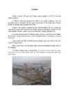
Tallinn English College English Sergo Vainumäe 9A TALLINN Report Supervisor: Inge Välja Tallinn 2006 Order of contents: 1.Introduction 2.Toompea 3.Lower Town 4.Kadriorg and Pirita 5.Museums 1. Introduction Tallinn, the capital of Estonia, lies on the Baltic Sea. It is on almost the same latitude east St. Petersburg in Russia, Stockholm in Sweden and Stavanger in Norway, and covers 158 sq km. Tallinn was first marked on a map of the world by the Arab geographer al-Idrisi in 1154, its name then being Kolyvan (probably derived from the name Kalev). In the 13th-century Chronicle of Henricus de Lettis the town was called Lyndanise. Later came Reval (presumably after the old county of Rävala), the name used by the Germans who ruled the country for seven centuries. Russians then
The tropical climates are found in Northern Australia. Warm ocean winds near the equator bring heavy rain to there areas, especially in summer, so that tropical rainforests grow there. The coastal areas, where the majority of Australians lives, have the most dependable rainfall in Australia. Westerlies bring winter rains to parts of Australia's southern coast. Australia's east coast gets rain all year round. Between the tropical north and middle latitude south, lie Australia's dry core-deserts. Deserts in that area receive almost no rainfall. In most areas of Australia rainfall is low and unpredictable. In conclusion, Australia has three biomes: tropical, savannas and desert. States and territories: The Commonwealth of Australia is made up of 8 states and territories: Western Australia, Southern Australia, New South Wales, Queensland, Victoria, Northern Territory, the Australian Capital Territory and Tasmania
It is unusual among Australian cities as an entirely purposebuilt, planned city. Following an international contest for the city's design, a design by Chicago architect Walter Burley Griffin was selected and construction commenced in 1913. The city's design was heavily influenced by the garden city movement and incorporates significant areas of natural vegetation that have earned Canberra the title "bush capital". Because of its latitude, elevation and distance from the coast, Canberra has four distinct seasons. The climates of most Australian coastal areas, which include all the state capital cities, are moderated by the sea. Canberra is home to many national monuments and institutions such as the Australian War Memorial, the National Gallery of Australia, the National Portrait Gallery currently housed at Old
Supported French during France-Britain war V North versus South · Different developments in the North and South All over the country School system Women rights South Agriculture: tobacco, rice, cotton (export to England) Cotton gin (1793) Slave labor (economics of south are based on slaves work) · Abolitionist movement Antislavery movement in 1800s Send free slaves to Liberia Help slaves flee their masters · Missouri compromise 5 Forbid slavery above 36°30' latitude Except Missouri · Fugitive Slave Act Fugitive- slave who has fled his master Free citizens should assist the return of fugitive slaves to their masters Result: Mexican American war · Underground Railroad Network of people who helped slaves escape south Hundreds of slaves each year used railroad terminology · Dred Scott case A black man who tried to sue for his freedom 1857 he lost the case
element that made confederation at least palatable was the concept of Two Nations. Thomas Paine, American revolutionary writer and political theorist (1776): "Europe and not England is the parent country of America." In Canada - Policy of multi-culturalism Pierre Trudeau, 1971. Canadian Multi-culturalism Act, 1988. In USA , no legislation of this kind. The 49th parallel north is a circle of latitude that is 49 degrees north of the Earth's equatorial plane. Although parts of Vancouver Island and parts of Eastern Canada are south of the 49th parallel, and parts of the United States (Alaska, Northwest Angle) are north of it, the term is used to refer to the entire Canada-U.S. border. 27. What differences are usually mentioned in the national character of the Canadians and the Americans?
o Romance -age – suffrage, passage, baggage, carriage, vicarage, village, homage, marriage -ment – detainment, banishment, embodiment, excitement, ligament, treatment, ornament -mony – matrimony, testimony, ceremony, sanctimony, alimony -tude – longitude, latitude, fortitude, solitude o Greek -ism – criticism, organism, barbarism, racism, sexism, fascism, colloquialism Verb forming o There are four suffixes which derive verbs from other categories (mostly adjectives and nouns), -ate, -en, -ify, and –ize. -ate -en -ify -ise/ize 20. Infixes
• Chartwork such as planned route; electronic bearing lines and range rings etc.; • Own ship's position and course/speed vector; ship's heading and rate of turn; past track; • Fix accuracy, or position check from secondary positioning system; • Possibly, shiphandling options, based on ship's characteristics; • Alphanumeric navigation information (ship's latitude, longitude, heading, course, etc.); • Information from radar and other sensors, • Information from AIS; • Navigational indications and alarms generated by ECDIS; • Possibly, telemetered information from shore authorities, (traffic, real-time tides etc.); • Possibly, ice information; • Reminders, (e.g. time to contact pilot station); and • Possibly, a message from other displays (e.g. alarm on engine room display).
considered quasi territory of the state only in international territories, not in the territories of other countries. International territory, regulated by IL includes high seas (open seas), the airspace above the high seas, deep seabed beyond the continental shelf, outer space including all natural space objects (moon, comets, starts etc), Antarctica (territory that goes from south latitude 60) Territory with mixed regime partially covered by sovereignty of the state and national law and partially by international law. Almost all territories covered by the law of the sea. First there are territorial waters that are covered by the state, then there are contiguous zone and exclusive economic zones and continental shelf. In
1957-72 295 285 300 355 350 320 300 295 285 310 Osoonikihi olukord Arktika kohal ei ole samuti kiita. V.Lutsu(1989) andmeil mõõdeti 1980 ndate aastate esimesel poolel Arktika kohal asuva osoonikihi õhenemise aastatempoks 1,5-2%. 1991/92,1992/93 oli osooni hulk Arktika kohal 15-20% tavalisest väiksem [31]. Second European Stratospheric Arctic and Mid-latitude Experiment 1994-1995 (SESAME) osalenud teadlased avaldasid 1995 aasta kevadel aruande, kus hoiatasid, et osoonikihi paksus on ka Arktika kohal kiiresti vähenemas. 1995 aasta kevadel oli osoonikihi paksus viimase 29 aasta kohta olevate andmete põhjal kõige väiksem. Polaarkeerise sees hävis osoon kiirusega 0,7% päevas. Märtsi lõpul oli vahemikus 14 -22 km osoonikihi paksus väiksem kui eelmistel aastatel samal ajal. Eriti suur
Calculator... avab dialoogalamak- na (vt. joonis 31), millel saab mit- mesuguseid ajalisi ja geograafilisi parameeteid muutes määrata päike- se asukohta (kaugvalgust kasuta- takse sageli just päikesevalguse imiteerimiseks). Redaktoriboksi- desse Date: ja Clock Time: saab kirjutada kuupäeva ja kellaaja (või Joonis 29. teha seda veoribade abil). Nendest allpool paikneb ajavööndi määramise loendiboks. Redaktoriboksid Latitude: ja Longitude: leiavad kasutamist geograafilise laiuse (0O kuni 90O, 0 vastab ekvaatorile) ja pikkuse (0 O kuni 180O, 0 vastab Greenwich'i meridiaanile) määramisel, kusjuures allpool paiknevatest loendiboksidest tuleb valida, kas on tegemist põhjalaiusega (North), lõunalaiusega (South), läänepikkusega (West) või idapikkusega (East). Käsunupuga Geographic Location... avaneb dialoogalamaken, mille kaudu on
GILS Government Information Locator Service GIMP GNU Image Manipulation Program GIMPS Great Internet Mersenne Prime Search GINA Graphical Identification and Authentication GIS Geographic Information System + Global Information Solutions [AT&T] GIX Global Internet Exchange [Internet] GKS Graphical Kernel System GL Graphics Language G/L General Ledger GLIS Global Land Information System [US Geological Survey] GLL Geograpic Position-Latitude/Longitude GLM General Linear Models GLOBE Global Learning by Observations to Benefit the Environment [Internet] .GLY Glossary (file name extension) [Microsoft Word] GMDI Gigabit Media-Dependent Interface GML Generalized Markup Language GMP Global Mobile Professional GMR Giant Magneto-Resistive (read head technology) GMRS General Mobile Radio Service GMS Global Management System + Global Messaging Service [Novell] GMT Greenwich Mean Time
Mid-Pacific Strategic Direction-Finder Net. By 1941, high-frequency direction-finders curved in a gigantic arc from Cavite in the Philippines through Guam, Samoa, Midway, and Hawaii to Dutch Harbor, Alaska. The 60 or 70 officers and men who staffed these outposts reported their bearings to Hawaii, where Rochefort's unit translated them into fixes. For example, on October 16, the ship with call-sign KUNA 1 was located at 10.7 degrees north latitude, 166.7 degrees east longitude—or within Japan's mandated islands. These findings did not serve merely to keep an eye on the day-to-day locations of Japanese warships. They also formed the basis of the even more fruitful technique of traffic analysis. Traffic analysis deduces the lines of command of military or naval forces by ascertaining which radios talk to which. And since military operations are usually accompanied by
Petersen?" He had the grace to look uncomfortable. "Yes, of course." "Is she telling him what she's doing?" "I don't know," he said stiffly. "That's Monica's private business. I don't interfere." No, he didn't. He coddled her. Indulged her. Spoiled her. And allowed her obsession with my safety to run wild. "She has to let it go. I've let it go." "You were an innocent, Eva. She feels guilty for not protecting you. We need to give her a little latitude." "Latitude? She's a stalker!" My mind spun. How could my mom invade my privacy like that? Why would she? She was driving herself crazy, and me along with her. "This has to stop." "It's an easy fix. I've already spoken with Clancy. He'll drive you when you need to venture into Brooklyn. Everything's been arranged. This will be much more convenient for you." "Don't try to twist this around to being for my benefit." My eyes stung and my throat burned
Indoor workers and athletes are top candidates for major insu ciencies: Lovell and collaborators found 15 of 18 elite female gymnasts tested to have levels below 30 ng/ml, and 6 to have levels below 20 ng/ml. to have levels below 20 ng/ml. Simple at-home tests (see the resources listed in the "Getting Tested" appendix) can tell you where you are, and consistent UV-B or sun exposure (2030 minutes at least twice per week, depending on latitude), along with sublingual D3, can get you to our minimal target of 50 ng/ml. More than 100 ng/ml is considered excessive, and more than 150 ng/ml is considered toxic. If you don't get tested and blindly take vitamin D, you run the risk of overdose. One mild overdose symptom can be a metallic taste in the mouth, which Neil from "Occam's Protocol" experienced. In our rush to start the program, and based on the average de ciencies I'd seen in