Leidsid 33 sarnast õppematerjali, mis on seotud failiga "Bora Bora". Need materjalid aitavad sul teemat sügavamalt mõista.
bora, island, tour, enjoy, round, islands, lagoon, here, blue, including, year, fish, visit, french, green, include, pearl, activities, tropical, waters, popular, tourist, mary, blood, other, rest, dependent, tourism, know, deep, fishing, going, hotels, volcanic, mountains, coral, found, trees, ocean, surrounding, considered, above, turquoise, therehigh elevations Coconut palms, pandanus trees, and breadfruit trees cover the landscape. Animal life is not found in abundance although, wild pigs, rats, and lizards can be seen from time to time. The ocean waters surrounding the island. The coral reef provides shelter to a large number of fish, sponge, and giant manta ray species. Climate data for Bora Bora Climate data for BoraBora Month Jan Feb Mar Apr May Jun Jul Aug Sep Oct Nov Dec Year Average high °C 30.2 30.8 30.5 30.3 29.5 28.6 28.1 28.1 28.6 29.1 29.4 29.6 29.3 (°F) Average low °C 25.1 25.3 25.5 25.5 25.1 24.2 23.8 23.8 24.0 24.3 24.6 24.8 24.7
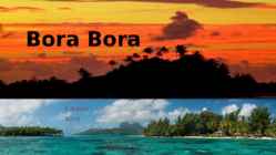
My dream destination is... FRENCH POLYNESIA The French Polynesia islands are located in the Pacific Ocean. It contains of many islands. The most famous are Tahiti, Bora Bora, Moorea. The islands are considered to be one of the most exotic places in the world; also known for its breathtaking beaches. The official language is French. SIGHTS Tahiti's volcano Rangiroa atoll Papetoai temple in Moorea Lagoon of Bora Bora Museums and botanical gardens in Tahiti Aquariums and zoos Tahitian dancing THINGS TO DO Jet skiing in Bora Bora Scuba diving in Tahiti Surfing in Tahiti Sailing in Bora Bora POLYNESIAN FOOD Known for its exotic fruits, fresh fish and vegetables, Strong influence from the French cuisine Seafood Restaurants in French Polynesia are from a wide variety of backgrounds including French,
Road and Borough Market to Wharf andAlcatraz. And, of appreciate the local culture. course, the city's crowning architectural achievement, the Golden Gate Bridge, is unmistakable. New York City and Maui Why go: Author Ayn Rand once Why go: Of all the Hawaiian Islands, wrote, "I would give the greatest Maui might be the most beloved. The sunset in the world for one sight of island encapsulates all that Hawaii has New York's skyline." While many to offer: exotic beaches (like disagree with her politics, her Kaihalulu), palatial resorts (like sentiment for the Big Apple is widely the Four Seasons Resort Maui at shared. America's most populous Wailea) and lush terrain (as seen in
Misso Keskkool New Zealand Precis Compiler: Maiki Joakit Instructor: Mailis Teppo Misso 2011 New Zealand is an island country in the south-western Pacific Ocean comprising two main landmasses (the North Island and the South Island), and numerous smaller islands, most notably Stewart Island/Rakiura and the Chatham Islands. The indigenous Mori language name for New Zealand is Aotearoa, commonly translated as land of the long white cloud. Population (1998): 3,801,000.New Zealand is notable for its geographic isolation; it is
Queenstown Beautiful lake side town is surrounded by mountains and is one of New Zealands premier tourist destinations. The home of bungee jumping and jet boating. Queenstown is also one of the southern hemispheres premier skiing destinations Rotorua Famous for its volcanic activity. Every reserve has spectacular examples of geysers, boiling pools, hot springs, boiling mud, volcanic terraces, and craters. Mt Tarawera nearby volcano offers spectacular scenery including superb views inside the rim of the volcano Best area in the country to experience and learn about Maori Culture. Top ten places to visit in New Zealand Bay of Islands Bay of Islands is the finest maritime park in New Zealand. There are about 150 islands. The park has an abundance of marine life, including marlin, whales, penguins and dolphins. Mt Cook National Park Mt Cook and surrounding area is an alpine park within the
The Edmonton Fringe Festival is the world's second largest after Edinburgh's. The Folk music festivals in both Calgary and Edmonton are two of Canada's largest and both cities host a number of annual multicultural events. With a large number of summer and winter events, Edmonton prides itself as being the "Festival City". The city's "heritage days" festival sees the participation of over 70 ethnic groups. Edmonton's Churchill Square is home to a large number of the festivals, including the large Taste of Edmonton & The Works Art & Design Festival throughout the summer months. Calgary is also home to Carifest, the second largest Caribbean festival in the nation (after Caribana in Toronto). Edmonton has Cariwest, a smaller Caribbean Parade in the downtown streets. Both Edmonton and Calgary are also known for decent Film festivals. The city of Calgary is also famous for its Calgary Stampede, dubbed "The Greatest Outdoor Show on Earth
coast. Across the country, Canadians experience many different landscapes from rolling plains and mountains to the cold tundra of the north. Geographically, Canada can be divided into five major regions : the Pacific Region, the Prairie Provinces, Central Canada, the Atlantic Provinces, and the North. The Pacific Region includes Canada's westernmost province, British Columbia. The region is known for its mild coastal climate, its forests, and its spectacular mountains, including the famous Rockies. The Rocky Mountains are the youngest and highest mountains in Canada. British Columbia is in the landform region called the Western Cordillera. ('Cordillera' means a system of mountain ranges). Between the mountain ranges are areas of high plateaus and deep trenches. Since the landscape is very rugged, most people live in the south and near the coast. Vancouver and Victoria are the largest cities in British Columbia. The region includes the
ago. When British came to Australia in 1788, they called these native people “aboriginals”, meaning people who had lived there since the earliest times. Captain James Cook set the colonization of Australia into motion by exploring and mapping the fertile eastern coast of Australia, but he was not the first to visit Australia. There is evidence suggesting Aborigines in northern Australia maintained trade with some of the Indonesian islands closest to the coast. Chinese and Arab's may have had contact with the Aborigines in the 15th century. When British people came to live in Australia, they decided that the land was empty, that there were no people living there. This was called "Terra nullius", Latin words for "empty land".Under British law, all land belongs to the king,who is then able to sell it to other people. The sacred sites and
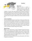
Ibiza Independed work Enelin Paistu LM08 Ibiza Ibiza is an island in the Mediterranean Sea 79km off the coast of the city of Valencia in Iberian Peninsula Spain. It is the third largest of the Balearic Islands, an autonomous community of Spain. With Formentera, it is one of the two Pine Islands or Pityuses. Its largest cities are Ibiza Town (Catalan:Vila d'Eivissa or simply Vila), Santa Eulària des Riu and Sant Antoni de Portmany. Eivissa is the official Catalan name (Catalan pronunciation:, locally. The name in Spanish is Ibiza . In British English, the name is usually pronounced in an approximation of the Spanish while in American English the pronunciation is more anglicized
elderly because Straitland was the one to bring Christianity to Estonia. The castle of Kuressaare is still standing proudly, but in Lihula only ruins can be seen. The patterns of national dresses and the churches bring memories of secret sign cultures of Medieval Times. Good knowledge of singing and facility of speech of the people of Straitland have given Estonia a big number of writers and poets. Character of the landscape The area of Straitland contains Pärnumaa county and some of the islands such as Saaremaa, Muhu, Kihnu, Ruhnu and Abruka. Straitland is low-lying and flat. It was flooded by the sea for much longer than the rest of mainland Estonia. The climate is maritime and greatly influenced by the Baltic Sea. The area features large bogs, extensive forests, coastal plains, warm and peaceful beaches, the lake Kaali with its mystical meteorite flight and a number of offshore islands. The islanders have their own customs, national costumes and speak their own local dialects
In Canada, the variety of landscapes shows the diversity of our climate. In the north, low precipitation and cold temperatures favour permafrost and suppress vegetation growth, resulting in treeless tundra. South of the tundra, on the Canadian Shield, summers are short and warm, and winters are long and cold. Annual precipitation is abundant, allowing coniferous forests to establish and grow. On the Pacific coast, the combination of heavy rainfall and mild temperatures year round supports Canada, Kärt Kalvet 8a temperate rain forests. On the Prairies, the large number of days of sunshine affects the development of the agricultural landscape. In the Maritimes, the Atlantic Ocean moderates the climate such that winters are generally long and mild, and summers are short and cool. These conditions help in the development of forests. Finally, around the Great Lakes and alongside the St
Canada is rich in natural wonders, one of them, the Niagara Falls between lakes Erie and Ontario, which is the second biggest waterfall in the world is one of the greatest attractions in the world. About twelve million tourists come to see the beauty of the falling waters on the border between the United States of America and Canada. The Horseshoe Falls, which lie in the territory of Canada, are much bigger and have more strength than the American Falls. People can enjoy the sight and the noise of the waters from boats which take them right next to the falls. And to stay dry people receive waterproof clothing. Parts of Canada are very mountainous and the tallest mountain in Canada is the Yukon's Mount Logan, which is 6050 meters tall. Canada has many mountain ranges. In the east there are the Appalachians, Torngats and Laurentias. In the western region there are the Rocky, Coastal and Mackenzie ranges and Mount St
.....................................................9 Vital waterways for people and wildlife..............................................................................................10 2 Introduction If you were asked to show on a world map the regions with the most biodiversity, your finger would probably end up pointing at the Amazon, the Congo Basin or the island of Borneo. But I chose New Guinea, an island that represents no more than 1% of the world's landmass, an array of extraordinary animals and plants have also flourished, such as tree kangaroos and birds of paradise. Close to 10% of the world's vertebrates are concentrated here, while 7% of the world's higher (vascular) plants grow on the island's productive soils. 3 Geography Papua New Guinea consists of over 600 islands and lies in the middle of the long
Western Australia , South Australia, The Australian Capital Territory and the Northern Territory). The Australian people are culturally the same as the Anglo Americans. There also live aborigines. Aborigines are the ancestors of the people. Like the US and Canada, Australia was an English speaking colony of Great Britain. Today Australia is a modern developed country with a diversified economy. Australia is an island continent of 7.7 million square kilometres, which makes it a little smaller than the USA. Located in south of Asia, between The Pacific and Indian Oceans, Australia is the World's driest continent. Although large areas of the centre are desert, Australia has a wide range of climate from tropical in the north to temperate in the south east, where it frequently snows in winter. Geographical position The coasts of Australia are surrounded by the Pacific Ocean, the Indian Ocean and the
JAMAICA The english speaking country · Jamaica is an island country situated in the Caribbean Sea, consisting of the third-largest island of the Greater Antilles (*The Greater Antilles is a grouping of the larger islands in the Caribbean Sea). · The flag consists of a gold saltire, which divides the flag into four sections: two of them green (top and bottom) and two black (hoist and fly). · black representing the strength and creativity of the people which has allowed them to overcome the odds, gold for the wealth of the country and the golden sunshine, and green for the lush vegetation of the island. · Coat of arms: On the dexter side a West Indian Native
Topic Australia Tallinn English College 2006 Australia 1 . Introduction The name Australia is derived from the Latin Australis, meaning of the south. In land area, Australia is the sixth largest nation, its territory is 7,686,850 sq km and its population reaches today over 20,5 million people. It is the only nation to govern an entire continent and its outlying islands. Australia's capital is Canberra, the only city with its own territory. It was built in the early 1900s just to be the capital. The official language is English and the official name of Australia is the Commonwealth of Australia. Australia is located on the Southern Hemisphere (because of that Australia is also called "A land down under"). 2 . Geographical position
................................ 8 Pictures........................................................................................................................................8 Used material:............................................................................................................................. 9 2 Introduction Jamaica is an island nation of the Greater Antilles, 234 kilometres (146 mi) in length and as much as 80 kilometres (50 mi) in width situated in the Caribbean Sea. It is about 620 kilometres (385 mi) northeast of the Central American mainland, 145 kilometres (90 mi) south of Cuba, and 190 kilometres (120 mi) west of the island of Hispaniola, on which Haiti and the Dominican Republic are situated. Its indigenous Arawakan-speaking Taíno
.............................. ......8 6.Sport.................................................................. ......9 7.Language........................................................... ....10 8.Conclusion......................................................... ....11 9.New words............................................................12 10.References...................................................... .....13 Introduction Jamaica is an island nation of the Greater Antilles, 234 kilometres in length and as much as 80 kilometres in width, amounting to 11, 100 km 2. It is situated in the Caribbean Sea. With 2.8 million people, it is the third most populous anglophone country in North America, after the United States and Canada. Kingston is the largest city in Jamaica and the country's capital. I am interested in this country and it is my favourite country. History
15,000 km) which makes it almost the same size as the mainland USA's coastline. Even though New Zealand is only about the same size as Colorado, the large coastline is possible because it is extremely iregular and indented. New Zealand's coastline is packed with deep coves, bays, intricate harbours, long sounds, and steep fiords. Its territorial waters stretch from the sub-tropical through to the sub-antarctic. Both islands tend to have better swimming beaches on their eastern coasts and the further north you go. The west coasts of both islands are quite rugged with cliffs and more unsettled weather. There are however some suitable swimming and bathing beaches here, with iron (volcanic) sand beaches (black sand) being common on the North Island. The longest beach in New Zealand is the 90 mile beach, which is actually about 60 miles long
Australia Australia is a country and also a continent. If someone wants to make clear, that he is speaking of the country, he may call it by its full name of Commonwealth of Australia. Australia's name means "southland."It is south of the equator. Sometimes it is also called the island continent because it is an island. There are about twenty million people in Australia.It is 1,800 miles from the mainland of Asia and almost half way round the world from Europe. More than 600 miles of ocean separate it from Americas. Since Australia is south of the equator, its seasons are just the opposite of ours. It has summer while we have winter, and the other way round. States and Territories. Australia consists of six states, two territories and eight external territories. The six states are: Western Australia (capital Perth), South Australia (capital Adelaide),
is 7 hours behind Greenwich Time, Pacific Standard Time. Alaska and Hawaii have their own time zones: Alaska Standard Time and Hawaii Standard Time. Geographical Position The USA lies in the Northern Hemisphere in North America. It covers a big part of the continent and is also the third largest country in the world. The country consists of 50 states, but two of them lie separately. One of them is Alaska, which is near the Arctic Circle. And the other state is Hawaii, which is a group of island is the Pacific Ocean. The USA shares the border with Canada in the north and Mexico in the south. In the east the coast is washed by the Atlantic Ocean and in the west by the Pacific Ocean. In the south there is the Gulf of Mexico. The highest mountain in the country is Mount McKinley, which is in Alaska. It's about 6 km high. But the lowest point is in Death Valley and its 89 m below sea level. Relief About half of the United States' territory is covered by plateaus and mountains. The
.......................................................................................................... 8 Population and Ethnicity..............................................................................................9 3 Introduction The official name of the country is the United Kingdom. The United Kingdom is an island country. It consists of the island of Great Britain and Northern Ireland. Great Britain can be divided into three parts England, Wales and Scotland. Each of them has their own capital city. Glasgow in Scotland, Cardiff in Wales and London in England. The country is situated in the north-western Europe. The territory of the United Kingdom is about 244,000 square kilometres and about 60 million people live there. The UK contains a number of small islands. The largest islands that belong to the United
The United Kingdom The United Kingdom consists of England, Scotland, Wales and North Ireland and it is situated in the Atlantic Ocean near the mainland of Europe. The population of the UK is 58.6 million and area is 244,110 sq km. Britain has a temperate humid climate. Its characteristic features are mild winters, warm summer, no temperature extremes, abundant rain all year round and frequent changes of weather. The mild climate is partly due to the warm Gulf Stream and partly to the south westerly winds. Occasional winds from the east in winter may bring cold and dry weather. The distribution of rainfall is influenced by the Atlantic Stream. The mountainous areas of the north and west have more rain than the lowlands of the south and east. Wales is located on a peninsula in central-west Britain. The entire area of Wales is about 20,779 km²
landscaper André Mollet. At the end of the 17th century and early 18th century were the cows in the park and could to buy fresh milk in "Lactarian". Location: The park is located in central London. This is 23 hectare large. St. James's Park is surrounded by Buckingham Palace to the west, The Mall and St. James's Palace to the North, Horse Guards to the east, and Birdcage Walk to the south. The park has a small lake, St. James's Park Lake, with two islands, West Island, and Duck Island, which is named for the lake's collection of aquatic birds. What to see and do in the park: Pelicans The first pelicans were given by a Russian ambassador in 1684. Living near Duck Island are the Park's famous resident Pelicans. Regular visitors can see the Pelicans basking on their favourite rocks and getting fed fresh fish at 2:30pm every day. There are currently five Pelicans in the Park. Horeseguards Parade
Great Britain Pärnu 2012 Contents Great Britain Great Britain or Britain is an island situated to the northwest of Continental Europe. It is the ninth largest island in the world, the largest European island, and the largest of the British Isles.
trading posts for several common types of tradable commodities at the time, ranging from gold to slaves, as they looked for a route to India and its spices, which were coveted in Europe. The Treaty of Tordesillas, intended to resolve the dispute that had been created following the return of Christopher Columbus, was signed on 7 June 1494, and divided the newly discovered lands outside Europe between Portugal and Spain along a meridian 370 leagues west of the Cape Verde islands (off the west coast of Africa). In 1498, Vasco da Gama reached India and brought economic prosperity to Portugal and its population of 1.7 million residents. In 1500, Pedro Álvares Cabral discovered Brazil and claimed it for Portugal. Ten years later, Afonso de Albuquerque conquered Goa in India, Ormuz in the Persian Strait, and Malacca, now a state in Malaysia. Thus, the Portuguese empire held dominion over commerce in the Indian Ocean and South Atlantic
Weather in Sidney Sydney's climate is pleasantly temperate all year round with more than 340 sunny days a year. In summer (December to February), average maximum temperatures in Sydney are around 26°C. It can also be humid at this time with an average humidity of 65 per cent. Average maximum temperatures in the winter (June-August) are around 16°C. Sydney's rainfall is highest between March and June. Appealling climate - Australian seasons are the opposite to the Northern Hemisphere, summer starts in December, autumn in March, winter in June and spring in September
Ibiza is an island in theMediterran e a n S 79 km e a off the coa st of the
Largest Cities........................................................................................5 4. Culture...........................................................................................................6 5. Conclusion .....................................................................................................7 6. References .....................................................................................................8 Introduction New Zealand is an island country in the southwest of Oceania. The Tasman sea separates New Zealand from Australia. The basic parts of New Zealand are the North Island and the South Island. Wellington - which is located on the South Island - is the most southern capital city in the world, but the biggest city in New Zealand is Auckland. There are three official languages in New Zealand: English, Maori and the New Zealand's Sign Language. In Maori language the island is also called Aotearoa
the world. Its area is about 7,6 million sq kilometers. Its population is about 20,0 million and most of the people live in bigger cities: Sydney (4.2 million), Melbourne (3.7 million), Brisbane (2 million) and in Canberra, Which is also the capital of Australia. National language in Australia is english and the monetary unit is Australian dollar. Australia is divided into 6 states and 2 territories. Symbols Australia has a British Union flag. It is red, white and blue. Five small stars represent the constellation Southern cross. The big star represents country's states and territories. In 1901 the flag was chosen from about 30000 entries in a public contest. It was officially adopted as Australian flag in 1953. The coat of arms features a kangaroo and an emu (the national animals of Australia), golden wattle (the national floral emblem), a shield with the coats of arms of the six states of Australia and a star for all states and territories.
people) and the yellow in the middle (representing the sun) is a source of pride for Indigenous Australians. The present coat of arms was granted by King George V in 1912. It consists of a shield containing the badges of six Australian states, enclosed by an ermine border. The shield is a symbol for the federation of the states, which took place in 1901. The crest, which is above the shield, is a seven-pointed gold star on a blue and gold wreath. The seven points of the star represent exactly the same thing that they do on the flag. The supporters of the shield are native Australian animals: the red kangaroo and the emu. Usually the coat of arms is depicted on the background of sprays of golden wattle with a scroll beneath it containing the word `Australia'. Australia's national anthem is `Advance Australia Fair', which replaced `God Save the Queen' in 1984
Bush. 2. Geographical position The United States of America is located on the continent of North America. It has borders with two countries Mexico and Canada. There are also the Atlantic Ocean, the Pacific Ocean and the Gulf of Mexico surrounding the big country. There are 50 states in America. Most of the people live in towns. The biggest state is Alaska; next by size are California, Alaska and Montana. Six states - Maine, Vermont, New Hampshire, Connecticut, Rhode Island and Massachusetts are called New England. They are all small states in the USA that lie in the north- east. The first colony of immigrants settled down in Virginia, in the eastern part of the USA. 3. Relief The USA is situated in the central part of the North American continent. Its western coast is washed by the Pacific Ocean and its eastern coast is washed by the Atlantic Ocean and in the south its coast is washed by the Gulf of Mexico. The coastline is even. There are no big islands
Commonwealth of Australia. It’s the official name of the country. Australia is the smallest continent, but one of the largest countries on Earth. It’s 6th largest country. Its area is about 7.6 million sq km. One third of it is occupied by deserts. It’s both the flattest and, except for Antarctica the driest. Neighbouring countries include Indonesia, East Timor and Papua New Guinea in the north, the Solomon Islands, Vanuatu in the northeast, and New Zealand in the southeast. Its capital is Canberra. Other big cities are Melbourne, Sydney, and Brisbane. National language in Australia is English. Monetary unit is Australian dollar. Their national holiday is on the 26th of January. In 1788 on the 26th of January the first fleet arrived at Botany Bay and established a penal colony near modern-day Sydney. Geographical Position Australia is located in the Southern Hemisphere. It’s the