Leidsid 33 sarnast õppematerjali, mis on seotud failiga "Republic of South Africa". Need materjalid aitavad sul teemat sügavamalt mõista.
africa, south, republic, capita, cultures, languages, billion, total, living, region, located, southern, square, 25th, cape, north, botswana, zimbabwe, diversity, official, ethnic, groups, black, asian, them, origin, english, democracy, president, jacob, zuma, assembly, council, ensure, taken, account, government, economy, nelson, mandela, bridgeThe Republic of South Africa History The Republic of South Africa is a country located at the southern tip of Africa, with a 2,798 kilometres coastline on the Atlantic and Indian Oceans. Modern humans have inhabited Southern Africa for more than 100,000 years. In 1652 the Dutch East India Company founded a refreshment station at what would become Cape Town. The discovery of diamonds and later gold triggered the conflict known as the Anglo-Boer War, as the Boers and the British fought for the control of the South African mineral wealth. Although the Boers were defeated, the British gave limited independence to South Africa in 1910 as a British dominion. South Africa contains some
Geography South Africa, on the continent's southern tip, is bordered by the Atlantic Ocean on the west and by the Indian Ocean on the south and east. Its neighbors are Namibia in the northwest, Zimbabwe and Botswana in the north, and Mozambique and Swaziland in the northeast. Eleven languages are spoken in South Africa : english, xhosa, zulu, afrikaans, venda, swazi, ndebele, tswana, tsonga,sepedi and soutj. There are black people, white people and different Asians living in South Africa. South Africa was a British colony and Indians were used there as slaves. South Africa has three capitals: an administrative capital Pretoria, a legislative capital Cape Town and a judicial capital Bloemfontein. South Africa's total area is 1,219,912 sq km and its population is 43,997,828. Economy Its agriculture is corn, wheat, sugarcane, fruits, vegetables; beef, poultry, mutton and wool. Most industries are mining, automobile assembly, metalworking, machinery,
South Africa Airi Pindis Misso Keskkool South Africa Capital There Are Actually Three Capital Cities (Pretoria, Bloemfontein and Cpe Town) Official language(s) 11 Ethnic groups 79.4% Black 9.2% White 8.8% Coloured 2.6% Asian Population 2010 estimate 49,991,300 Currency Rand (ZAR) The South African rand (ZAR), is the most actively traded emerging market currency in the world inglise Republic of South Africa afrikaani Republiek van SuidAfrika koosa IRiphabliki yaseMzantsi Afrika ndebele Riphabliki yeSewula Afrika pedi Rephaboliki ya Afrika Borwa sotho Repabliki ya AfrikaBorwa suulu iRiphabliki yaseNingizimu Afrika svaasi Riphabliki yase Ningizumu Afrika tsonga Riphabliki ra Afrika Dzonga tsvana Repabliki ya AfrikaBorwa
The Republic of Cameroon Cameroon · A unitary republic of central and western Africa · Bordered by Nigeria to the west; Chad to the northeast; the Central African Republic to the east; and Equatorial Guinea, Gabon, and the Republic of the Congo to the south. · Cameroon's coastline lies on the Bight of Bonny, part of the Gulf of Guinea and the Atlantic Ocean. · The country is called "Africa in miniature" for its geological and cultural diversity. History · The territory of present day Cameroon was first settled during the Neolithic · Portuguese sailors reached the coast in 1472 · The German Empire claimed the territory as the colony of Kamerun in 1884 and began a steady push inland.
what are `territorial politics' The multi-level politics of federal, regionalised, devolved states Distribution of power between central and regional government Party competition across levels of government `Regions' as spheres for autonomous action South Africa Mexico Germany · 9 provinces · 31 states plus federal district · Developed democracy · `Cooperative' federalism · Predominant role for federal 16 Laender
8a Teacher: Merike Sisask Composer: Kärt Kalvet 2010 Canada, Kärt Kalvet 8a Canada General Information Canada is in North America. It's area is 9220970 sq km. Canada's population is 313.612.000 people. Canada is divided into 10 provinces and 3 territories. The capital of Canada is Ottawa. Canada has constitutional monarchy. The head of state in Canada's government is the Queen of England. There are two main languages in Canada: English and French. Canada's curreny is Canadian dollar (1 dollar=100 cents[Can$]). The highest peak of Canada is Mount Logan, 5959 metres. The lowest point is sea level. The longest river is the Mackenzie. The climate and geography of Canada vary greatly from temperate in the south to arctic in the north and from islands and plains in the east to mountains in the west. Location Canada is located in the northern-most region of North America. It's geographical position in co-
Cuisine of South Africa has had a variety of sources and stages: · Cookery practised by indigenous people of South Africa such as the Khoisan and Xhosa- and Sotho-speaking people · Settler cookery introduced during the colonial period by people of Indian and Afrikaner and British descent and their slaves and servants - this includes the cuisine of the Cape Malay people, which has many characteristics of Malaysia and Java, and recipes from neighbouring colonial cultures such as Portuguese Mozambique. Indigenous cookery traditional South African cuisine
6. Changes in the number of population since the 1840s. 1841: 6.5M in Ireland, 8.2M on the island 1901: 3.2M in Ireland, 5M on the island 1951: 3.0M in Ireland, 4.4M on the island 2011: 4.6M in Ireland, 6.4M on the island Causes of emigration from Ireland. The Irish Famine caused some 150,000 people to leave the island. The Great Famine (1845-52) killed roughly a million and prompted another million to emigrate. In 1890, 40 % of Irish people were living abroad "Exodus in reverse" has been used to describe Irish people returning to Ireland, especially from the US. Immigration from many countries, but mostly from Poland, the UK, Lithuania, Latvia, Nigeria and Romania. Is Ireland still an emigration country? No 7. What is the difference between the Irish Free State and the Republic of Ireland? All three names refer to the same country (Northern Ireland was part of the Irish Free State for one day, if you want to be really pedantic).
SOCIETY AND CULTURE OF ENGLISH-SPEAKING COUNTRIES Introduction 1. Nowadays, English is so widely spoken that it can hardly be considered "a one nation's" language. The main countries where English is spoken are: the U.K, the U.S, Canada, Australia, the Republic of Ireland, New Zealand, West Indies 2. There are approx. 300-400 million speakers of English in the world. English occupies the 3rd place by its number of speakers; it is right behind Mandarin and Spanish. 3. ESL (English as a Second Language) used in your own country (e.g. India) EFL (English as a Foreign Language) used in a foreign country ESP (English for Specific Purposes) used in business, airlines, hotels etc. 4
Finland was a province and then a grand duchy under Sweden from the 12th to the 19th centuries, and an autonomous grand duchy of Russia after 1809. It won its complete independence in 1917. During World War II, it was able to successfully defend its freedom and resist invasions by the Soviet Union albeit with some loss of territory. In the subsequent half century, the Finns made a remarkable transformation from a farm/forest economy to a diversified modern industrial economy; per capita income is now among the highest in Western Europe. A member of the European Union since 1995, Finland was the only Nordic state to join the euro system at its initiation in January 1999. In the 21st century, the key features of Finland's modern welfare state are a high standard of education, equality promotion, and national social security system currently challenged by an aging population and the fluctuations of an exportdriven economy (Central Intelligence Agency, 2012, ISSN 15538133).
Introduction Jamaica is an island nation of the Greater Antilles, 234 kilometres (146 mi) in length and as much as 80 kilometres (50 mi) in width situated in the Caribbean Sea. It is about 620 kilometres (385 mi) northeast of the Central American mainland, 145 kilometres (90 mi) south of Cuba, and 190 kilometres (120 mi) west of the island of Hispaniola, on which Haiti and the Dominican Republic are situated. Its indigenous Arawakan-speaking Taíno inhabitants named the island Xaymaca, meaning either the "Land of Springs," or the "Land of Wood and Water". Formerly a Spanish possession known as Santiago, it later became the British West Indies Crown colony of Jamaica. It is the third most populous anglophone country in the Americas, after the United States and Canada. I chosed Jamica because there are many things what I like in this country. Mostly I
7 million square miles (over 9.6 million km²) and population more than 300 million people. The capital city is Washington D.C. Although the United States has no official language at the federal level, English is the de facto national language. English is the most common language for daily interaction among both native and non-native speakers. Spanish is the second language. The largest city is the New York City. The Government is Federal constitutional republic and the president is George W. Bush. 2. Geographical position The United States of America is located on the continent of North America. It has borders with two countries Mexico and Canada. There are also the Atlantic Ocean, the Pacific Ocean and the Gulf of Mexico surrounding the big country. There are 50 states in America. Most of the people live in towns. The biggest state is Alaska; next by size are California, Alaska and Montana
Introduction Estonia, officially the Republic of Estonia (Estonian: Eesti or Eesti Vabariik) is a country in the Baltic region of Northern Europe. It is bordered to the north by Finland across the Gulf of Finland, to the west by Sweden across the Baltic Sea, to the south by Latvia (343 km), and to the east by the Russian Federation (338,6 km). The territory of Estonia covers 45,227 km² and is influenced by a temperate seasonal climate. The Estonians are a Finnic people closely related to the Finns, with the Estonian language sharing many similarities to Finnish. The modern name of Estonia is thought to originate from the Roman historian Tacitus, who in his book Germania (ca. AD 98) described a people called the Aestii. Similarly, ancient Scandinavian sagas
must take into account national sovereignty as well as global needs. The organization won the 2001 Nobel Peace Prize, and a number of its officers and agencies have also been awarded the prize. Other evaluations of the UN's effectiveness have been mixed. Some commentators believe the organization to be an important force for peace and human development, while others have called the organization ineffective, corrupt, or biased. 2. General knowledge on your delegation COUNTRY: Syrian Arab Republic POPULATION: Over 13 million LANGUAGE: Arabic (official); French; English RELIGION: Islam, Christianity, Druze, Judaism, Baha'i Syrian Arab Republic, more commonly known as Syria. The fertile land of Syria lies at the crossroads of great trade routes between the East and West. It is also the site of many holy places in Judaism, Christianity, and Islam. Because of these advantages, it has been invaded, conquered, and occupied by many different peoples over its long history
I. Portugal ABOUT Photo Location of Portugal (dark green) Portugal (Portuguese: Portugal, IPA: [putua]; officially the Portuguese Republic, Portuguese: República Portuguesa) is a country located in Southwestern Europe, on the Iberian Peninsula. It is the westernmost country of mainland Europe, and is bordered by the Atlantic Ocean to the west and south and by Spain to the north and east. The Atlantic
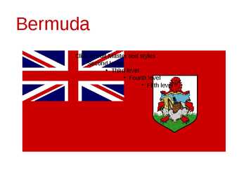
Second level Third level Fourth level Fifth level Bermuda (officially, the Bermuda Islands or the Somers Isles) is a British overseas territory in the North Atlantic Ocean Located off the east coast of the United States, it is situated around 1,770 kilometres northeast of Miami, Florida, and 1,350 kilometres south of Halifax , Nova Scotia, Canada. The nearest landmass is Cape Hatteras, North Carolina, about 1,030 kilometres west-northwest. It is the oldest and most populous remaining British overseas territory, settled by England a century before the Acts of Union created the United Kingdom of Great Britain. Bermuda's first capital, St. George's, was settled in 1612 and is the oldest continuously inhabited English town in the Americas. Although commonly referred to in the singular, the
is the second largest country in the world with a territory of about 10 million square kilometers and it is bordered by three oceans: the Arctic, the Pacific and the Atlantic Oceans. The population of Canada is about 31 million people. About 77% of the people live in cities which lie in a band about 100 miles wide above the border of the United States. The capital of Canada is Ottawa. Other large cities are Montreal, Toronto, Vancouver, Winnipeg and Quebec. Canada has two official languages English and French. It's interesting to know that about 61% of Canadians name English and 24% French their mother tongue. There are also many other languages spoken in Canada such as: Italian, Chinese, German, Polish, Ukrainian, Greek and Dutch. There are also many native languages such as Algonquian. The British and the French as the main settlers from Europe fought for hundreds of years before they managed to build up a country which was based on recognizing the
Russia. It stretches from the Atlantic Ocean in the east to the Pacific Ocean in the west and to the Arctic Ocean in the North. Canada Covers most of the northern part of North America and its geography is very diverse. Canada's area is about 10 million square kilometers and its population is 31 000 000. Its capital is Ottowa and other main cities are Toronto, Montreal and Vancouver. Almost 75 % of canadians lives within 300 kilometer of the USA border, because the climate is softer in the South. 89 % of Canada is almost unhabited. Its official languages are English and French, but many other languages are spoken too. Like Italian, Chinese, German, Polish, Ukrainian, Dutch and Creek. There are also many native languages such as Algonquian. Most of the canadian's speak English (67 %), but French is very largely spoken too (26 % of the canadians). Canada is based on recognizing the cultural diversity of different nations living in Canada
Washington Washington is a state in the Pacific Northwest region of the United States located north of Oregon, west of Idaho, and south of the Canadian province of British Columbia on the coast of the Pacific Ocean. It was named after George Washington, the first President of the United States, the state was made out of the western part of the Washington Territory, which had been ceded by Britain in 1846 in accordance with the Oregon Treaty in the settlement of the Oregon Boundary Dispute. It was admitted to the Union as the 42nd state in 1889. Olympia is the state capital of Washington.
i. Elektrienergia tarbimine electricity consuption - 348.000 miljonit kwh aasta kohta, koht maailmas on 11-s Märkus! Osad andmed olen võtnud: http://www.citypopulation.de/cities.html . Järgmised vastused leiad http://www.citypopulation.de/cities.html . Liigu lingile world by map, edasi leia riik ja sealt Energy ja sealt electricity production. Ilmub tabel, mille päises on tulp per capita .Elektrienergia toodang- in/kohta kwh/a 6.071 ja mitmendal kohal riik on maailmas 43. Kui suur on maailma keskmine (tabeli lõpus) el.en. toodang- in/kohta 2.881 kwh/a. Lähtudes leitud andmetest tee järeldus ja anna hinnang oma riigi kohta. Elektrienergia toodang on suurem umbkaudu kaks korda suurem, kui maailma keskmine seega võin arvestada, et Suurbritannia on kõrgelt arenenud riik, küll
It is the eight largest city in Europe. Most Finns speak Finnish. The second language is Swedish. Finland is rated the sixth most peaceful country in the World. In Finland there are more than 60000 lakes. Capital: Helsinki Area: 338145km2 Population: 5200000 Language: Finnish, Swedish Currency: Euro (EUR) Goverment: Parliamentary republic President: Tarja Halonen Prime Minister: Matti Vanhanen 1 Nature and geography Finland is a country of thousands of lakes and islands; 187,888 lakes (larger than 500 m²) and 179,584 islands to be precise. One of these lakes, Saimaa, is the fifth largest in Europe. The Finnish landscape is mostly flat with few hills and its highest point, the Halti at
political refugees, persons who claim persecution or reasonable fear of persecution in Russia. Largest Russian communities today are in New York, California and Florida. 5. From where did the Indians come to America? *Native Americans aka. Indians, Red Indians, Redskins, American Indians, Amerindians, Namerind, First Nations people (Canada) *Origins of N-Am, theories = Bering Land Bridge theory = North American Indians are the people whose ancestors were living in North America when the Europeans discovered the Western Hemisphere. They often are called red men, or redskins, and they were named Indians because Columbus thought that he had reached the East Indies in his voyage across the Atlantic. Stone-age people who were to become American Indians began entering America at least 10,000 years ago. Most experts believe the first Indian ancestors arrived 30,000 or more years ago. Clovis, 13 500 years ago. They probably came from Asia
Australia presents an enormous range of climatic conditions, since it covers thirty degrees of latitude. It is mostly temperate, but one third of the continent is tropical, and there are large desert areas. The two largest cities are Sydney and Melbourne. The capital of Australia is Canberra. It is a small city and was built in the early 1900s. History. Two hundred years ago there were no white people in Australia. The only inhabitants were dark-skinned people who were still living in a Stone Age. Their only weapons were stone knives and boomerangs. But their tribes had very well-worked- out customs. A few aborigines still live in the emptier part of the continent. In 1770, the British explorer Captain Cook raised the British flag. Cook found there a pleasant climate and beautiful forests. The British initially used Australia as a gigantic prison camp for convicts from Britain. Then other people from Britain began to settle there as well. The
55,7 million acres Unevenly distributed Tribal sovereignty (iseseisvus) Poverty and unemployment · Indian citizenship Act of 1924 Granted citizenship to 300,000 indigenous people, to friendly tribes State support was limited Absorb Indians into the mainstream Didn't have the right to vote · Trail of Broken Treaties of 1972 Took place in 1972 Cross-country protest by American Indian organizations Intended to bring attention to American Indian issues such as treaty rights, living standards, and inadequate housing. Huge media coverage "20-Point Program" · Present situation 1 Reservations situated west of the Mississippi 1% of the population Minority group, less privileged Social problems Self-awareness Mixture of old and new HOW GOVERNMENT ACTS NOW- gives natives money and near Las Vegas the right to own casinos to compensate injustice and taking away land. II First Settlements
financing criteria and priorities. The current reading material summarises the main aspects covered by lectures and structurises the information channels for the future. The course supports the other Traderun courses, especially the course related to EU cooperation with Russia and Eastern Partnership Countries. 4 1. UKRAINE 1.1. General information 1.1.1. Country Profile Capital: Kyiv. Total area: 603,550 sq. km (the largest country in Europe by area that is physically within Europe entirely). Population: ~ 45 million (declining). Major cities and estimated population (Good news! Not all the business and capital concentrated in the capital): Kyiv (Kiev) 2.8 million, Kharkiv (Kharkov) 1.5 million, Lviv (Lvov) - 1.5 million, Donetsk 1 million, Dnipropetrovsk (Dnepropetrovsk) - 1 million, Odesa (Odessa) 1 million.
About 77% of the people live in cities which lie in a band about 100 miles wide above the border of the United States. The capital of Canada is Ottawa. Other large cities are Montreal, Toronto, Vancouver, Winnipeg and Quebec. 2. Geographical position Canada is a huge country in the continent of North America. It is bordered with the Atlantic Ocean in the east, the Pacific Ocean in the west, the United States of America in the south and the Arctic Ocean in the north. Canada is a vast country, with a territory of 3.8 million square miles of land and fresh water it is the second biggest country in the world after Russia. Canada covers most of the northern part of North America. Canada has over 151,480 miles of coastline. Most of Canada's human population lives along its southern border. 3. Relief Canada's geography is very diverse
information, contacts and project management support to potential investors. IBA services: Macroeconomic data on Bulgaria Data on operational costs Regional information Personalized administrative servicing Legal advice Liaison with central and local governments Liaison with branch chambers and NGOs www.investbg.government.bg GENERAL INFORMATION Official name: Republic of Bulgaria Area: 110 994 sq.m. Population: 7.4 million Capital: Sofia Time zone: EET (UTC+2) Official language: Bulgarian Currency: Lev (BGN) Fixed exchange rate: 1 = BGN 1.95583 Type of government: Parliamentary Member of: EU, NATO, WTO www.investbg.government.bg DID YOU KNOW THAT BULGARIA
CANADA REVISION QUESTIONS 2010 1. The main physiographic regions of Canada. Canada may be divided into seven physiographic regions: Arctic Lowlands, Cordilleran Region, Interior Plains, Hudson Bay Lowlands, Canadian Shield (Forest Lands), St Lawrence Lowlands and Appalachian Region. Divisions are based on each area's relatively similar physical geography and landforms. Physiographic regionalization is defined here as the process by which regions with relatively homogeneous physical geography are determined 2. Who are the native people of Canada? Into which three groups can they be divided? Canada's constitution specifies three categories of aboriginal peoples: Indian (First Nations), Métis, Inuit. According to Canadian census 2011, 1
across the country, Canadians experience many different landscapes from rolling plains and mountains to the cold tundra of the north. Despite Canada's great size, it is one of the world's most sparsely populated countries. This fact, coupled with the grandeur of the landscape, has been central to the sense of Canadian national identity. 2. Geographical position Canada is the second largest country in the world after Russia. In the Arctic, Canada reaches almost as far north as Greenland. To the south it extends to the same latitude as southern France. The distance from Canada's west coast, the Pacific Ocean, to its east coast, the Atlantic Ocean, is farther than from North America to Europe. Canada's total land area includes thousands of adjacent islands, notably Newfoundland in the east and those of the Arctic Archipelago in the north. In longitude Canada extends from approximately 52° to 141° W, a distance that spans six time zones
................................................................................................................................................5 PEOPLE.........................................................................................................................................................................6 UNITED STATES...........................................................................................................................................................6 AFRICA........................................................................................................................................................................7 BRAZIL........................................................................................................................................................................8 SPANISH-SPEAKING COUNTRIES.........................................................................................................................
South Africa Apartheid and before South Africa was created by peoples from Africa, Asia, and Europe. created their own states , combined (sometimes through war, sometimes through negotiation) to form the current South African state. The important thing is not what states were called or how long they lasted, but how they were organised, maintained control, gained and lost legitimacy. South African state formed out of: Conquest Colonization Slavery Indentured labour Racially discriminatory laws reserved jobs for whites; differential pay-scales etc Post 1910 state strong and centralized institutionalised racism: "power, wealth and privileges [distributed] unequally on a racial basis" (Giliomee, 1995, p190) Farming and mining (the basis of the economy) both required large work forces
THE CAPITALIST NIGER Chika Onyeani ………………………Every African must internalise this book - period….DAA INTRODUCTION In October 1960, Nigeria received its independence from Britain. By then, Ghana the former Gold Coast had been independent for three years under the great Osagyefo Kwame Nkumah. It was a time for celebrating Africa’s coming of age, as more and more African countries received their independence either from Britain or France. It was especially a poignant time for Africa, as then British Prime Minister Harold McMillan articulated his now famous “winds of change” sweeping Africa. We had high hopes for Africa, for the Black race, that the insidious imposition of foreign rule on us, the looting of Africa’s natural resources by our colonial masters accorded us would be things of history. That is more than forty years ago. Unfortunately, the promise of independence has not been fulfilled.
Kingdom are the Isle of Man in the Irish Sea and the Isle of Wight which lies off of England's southern coast. The largest groups of islands are the Shetland Islands, the Orkney Islands and the Hebrides. Geographical Position The UK is situated in the Northern Hemisphere. The United Kingdom is bordered by the Atlantic Ocean in the west, the North Sea in the east, the Norwegian Sea in the north, and the English Channel, also known as La Manche, in the south and it also separates the country from the continent of Europe. The neighbours of the United Kingdom are Iceland in the north-west, Norway in the east and France in the south. Britain also has many dependant territories which are scattered throughout the world and are the remains of the huge former British Empire. Today Britain assists them, but they may become independent whenever they wish. There have been some difficulties with some of the territories. Argentina has made