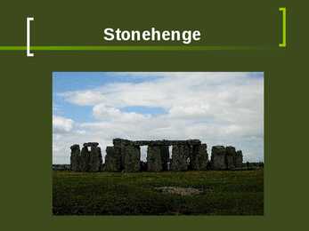
2500-1500BC, monument constructed, arranged and re- arranged "Mystery of Stonehenge" Multiplicity of theories: Stonehenge was domain of the dead, Woodhenge was land of the living. Place of healing. Observatory, temple Used for astronomical views. Construction Three periods: Period I (c. 2950-2900 BC) - circular enclosure (56 Aubrey holes and 4 Station Stones inside it), outlined by two banks, ditch with an entrance to the northeast, heel stone, Period II (c. 2900-2400 BC) - unclear, (bluestones were brought in, post-holes were used to create a structure) Period III (c. 2550-1600 BC) - 1 circle of sarsen-stones and in it 2 circles of bluestones, (Altar Stone was placed), horseshoe-shaped setting of 5 sarsen trilithons (opening pointing to the northeast side) Stonehenge tour No Dogs Audio tour Admission prices: Adult £6.50 Concession £5.20
Today, most portions of the Great Wall of China have been destroyed due to sandstorm erosion and vandalism. Only some portions of the Great Wall have been preserved and reconstructed for tourism purpose. Among all, the Badaling section which is located 80 kilometers northwest of Beijing City is the most well preserved section of the Great Wall and also the most visited. Other sections which are within the Beijing municipality are the Mutianyu section which is 70 kilometers northeast of Beijing, the Jinshanling section which is 120 kilometers northeast of Beijing and the Simatai section which is also 120 kilometers northeast of Beijing. The following clip shows a visit to the Mutianyu section of the Great Wall. The Great Wall of China is the world's longest time consuming project. The Wall also incorporates ancient Chinese architecture skills. In 1987, the Great Wall of China was enlisted as a UNESCO World Heritage Site
Famous people of England Quiz. nimi 2014 1. Name the English mathematician who devised a mechanical calculating machine in 1834 which was the forerunner of modem computers. 2. With what do you associate the names of Mary Read and Anne Bonny, who lived during the eighteenth .century? 3. She was an English heroine who, with her father rescued the crew of the ship Forfarshire which was wrecked on the Fame Islands on the northeast coast of England in 1838. Who was she? 4. What was Casanova's occupation at the time of his death? 5. What was the name of the Hunchback of Notre Dame 6. Which broadcaster, who died in 1985, is most remembered for presenting Desert Island Discs? Vastused: 1. Charles Babbage 2. Piracy 3. Grace Darling 4. Librarian 5. Quasimodo 6. Roy Plomley
Environment in Estonia Nowadays environmental problems are too big to be managed by individual persons or individual countries. In other words, it is an international problem. But what are the biggest problems in Estonia,why and how people could solve it? Air, water, and land pollution rank among Estonia's most significant environmental challenges. The combination of 300,000 tons of dust from the burning of oil shale by power plants in the northeast part of the country and airborne pollutants from industrial centers in Poland and Germany poses a significant hazard to Estonia's air quality. Estonia's water resources have been affected by agricultural and industrial pollutants, including petroleum products, which have also contaminated the nation's soil. Some rivers and lakes within the country have been found to contain toxic sediments in excess of 10 times the accepted level for safety.
19. South of the Pennines, also knows as the industrial heart of the United Kingdom 20. Agriculture contributes 2 per cent of... Down 1. Type of rainfall, is called the... 2. The main employment activity in the year of 2000. 3. What is mined in South Wales, Midlands, Lancashire, Yorkshire, Northeast England and the Central Valley of Scotland? 4. The people from Scotland are called the... 5. A river that rises in Central Wales and falls into the Bristol Channel, is the.. 8. Britain is split into them, an area with its own local government 9. Northern Ireland is also known as... 11
fashion, and dance styles. The white people thought of R&B as black music during the 1940's and early 50's. It has the single greatest influence on music worldwide for most of the 20th century. Its influence can be traced in forms of rock music, country, gospel, jazz even Nigerian Juju -a style of dance music. So it included many different musicstyles and because of that it likes many different humangroups. Rhythm and Blues was started in the South, but later moved to Midwest, Northeast, and West Coast cities due to the shift in American demographics, after World War II. One of two significant developments, which occurred that had an effect on R&B was the invention of the Magnetic Tape, the other was the formation of broadcasting companies. Over the decades, thanks to different artists and their styles, R&B has evolved into what it is today. My favourite R&B aritsts are Kelly Rowland, LeToya, Beyonce, Lauryn Hill, Mario and Usher.
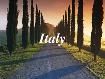
the world, which close own gates for every night . Inhabitants of Vatican have own radio and TV, currency and postage stamps. San Marino is the oldest republic in the world and it has less than 30 000 inhabitants. There are 14 volcanoes in Italy, four of which are active: Etna, Stromboli, Vulcano and Vesuvius. Etna is also the activiest volcano in the world. 60% of cultural world heritage is in the Italy Venice is a city in northeast Italy sited on a group of 118 small islands separated by canals and linked by bridges. Venice is renowned for the beauty of its setting, its architecture and its artworks. The city in its entirety is listed as a World Heritage Site, along with its lagoon. Italian chefs produce more than 350 different types of pasta. Every Italian eats on average 25 kg of pasta per a year. The Venice International Film Festival is the oldest international
Geography South Africa, on the continent's southern tip, is bordered by the Atlantic Ocean on the west and by the Indian Ocean on the south and east. Its neighbors are Namibia in the northwest, Zimbabwe and Botswana in the north, and Mozambique and Swaziland in the northeast. Eleven languages are spoken in South Africa : english, xhosa, zulu, afrikaans, venda, swazi, ndebele, tswana, tsonga,sepedi and soutj. There are black people, white people and different Asians living in South Africa. South Africa was a British colony and Indians were used there as slaves. South Africa has three capitals: an administrative capital Pretoria, a legislative capital Cape Town and a judicial capital Bloemfontein. South Africa's total area is 1,219,912 sq km and its population is
provide an important export for Ghana. Ghana's climate, like that of the rest of the Guinea Coast, is determined largely by the interplay of two air masses: a hot, dry continental air mass that forms over the Sahara and a warm, humid maritime tropical air mass that forms over the South Atlantic. Both air masses move toward the Equator with their hemispheric winds and meet at the Guinea Coast for several months each year. Continental air moves southward with the northeast trade winds, known in western Africa as the harmattan, and maritime tropical air moves northward with the southwest trades.
countries speaking 224 different languages . Los Angeles is also the seat of Los Angeles County, the most populated and one of the most multicultural counties in the United States. The city's inhabitants are referred to as "Angelenos". The city is divided into many neighborhoods, many of which were incorporated places or communities that were annexed by the city. Generally, the city is divided into the following areas: Downtown Los Angeles, The Eastside and Northeast Los Angeles, South Los Angeles , the Harbor Area, Hollywood, Wilshire, the Westside and the San Fernando and Crescenta Valleys. Important landmarks in Los Angeles include Chinatown, Koreatown, Little Tokyo, Walt Disney Concert Hall, Kodak Theatre, Griffith Observatory, Getty Center, Los Angeles Memorial Coliseum, Los Angeles County Museum of Art, Grauman's Chinese Theatre, Hollywood Sign, Hollywood Boulevard, Capitol Records Tower, Los
populous city in the state of California and the western United States, with a population of 3.83 million. Los Angeles is home to people from more than 140 countries speaking 224 different languages. The city is divided into over 80 districts and neighborhoods, many of which were incorporated places or communities that were annexed by the city. Generally, the city is divided into the following areas: Downtown Los Angeles, The Eastside and Northeast Los Angeles, South Los Angeles , the Harbor Area, Greater Hollywood, Wilshire, the Westside and the San Fernando and Crescenta Valleys. Important landmarks in Los Angeles include Walt Disney Concert Hall, Kodak Theatre, Griffith Observatory, Getty Center, Getty Villa, Los Angeles Memorial Coliseum, Los Angeles County Museum of Art, Grauman's Chinese Theatre, Hollywood Sign, Hollywood Boulevard, Capitol Records Tower, Los Angeles City Hall,
RAILWAY MUSEUMS IN HAAPSALU AND LAVASSAARE Four museums lines and some industrial peat railways remain in Estonia. The Lavassaare railway museum houses a large collection of steam and diesel locomotives with a 2 km long 750 mm gauge railway. There is a museum with a 750 mm gauge, 500 m long line in Avinurme which houses one locomotive and a collection of wagons. An underground museum with a short electric line is located in Kiviõli in the Northeast-Estonian industrial area. A former military railway line with a 750 mm gauge is located on Naissaar Island in the northern Estonia. . KASUTATUD KIRJANDUS http://en.wikipedia.org google.ee google.com .
Ireland Ireland is the third-largest island in Europe and the twentieth-largest island in the world. It lies to the north-west of continental Europe and is surrounded by hundreds of islands and islets. To the east of Ireland is the island of Great Britain. The Republic of Ireland covers five- sixths of the island. It is a parliamentary democracy and a republic. It is bordered to the northeast by Northern Ireland, which is a part of the United Kingdom, and is otherwise surrounded by the Atlantic Ocean: particularly, the Irish Sea to the east, St George's Channel to the southeast, and the Celtic Sea to the south. The population of Ireland is estimated to be 6.2 million. Thick woodlands covered the island until the 1600s. Today, it is the most deforested area in Europe. Twenty-six mammal species are native to Ireland, with some, such as the red
Egypt (Geography)Egypt officially the Arab Republic of Egypt, is a country mainly in North Africa. Egypt is a transcontinental country. Covering an area of about 1,010,000 square kilometers, Egypt is bordered by the Mediterranean Sea to the north, the Gaza Strip and Israel to the northeast, the Red Sea to the east, Sudan to the south and Libya to the west.Apart from the Nile Valley, the majority of Egypt's landscape is a desert. The winds blowing can create sand dunes more than 100 feet (30 m) high. Egypt includes parts of the Sahara Desert and of the Libyan Desert. Egypt does not receive much rainfall except in the winter months. Temperatures average between 80 °F (27 °C) and 90 °F (32 °C) in summer, and up to 109 °F (43 °C) on the Red Sea coast
Bermuda Click to edit Master text styles Second level Third level Fourth level Fifth level Bermuda (officially, the Bermuda Islands or the Somers Isles) is a British overseas territory in the North Atlantic Ocean Located off the east coast of the United States, it is situated around 1,770 kilometres northeast of Miami, Florida, and 1,350 kilometres south of Halifax , Nova Scotia, Canada. The nearest landmass is Cape Hatteras, North Carolina, about 1,030 kilometres west-northwest. It is the oldest and most populous remaining British overseas territory, settled by England a century before the Acts of Union created the United Kingdom of Great Britain. Bermuda's first capital, St. George's, was settled in 1612 and is the oldest continuously inhabited English town in the Americas.
Klõpsake juhtslaidi teksti laadide redigeerimiseks Teine tase Natural park Kolmas tase Neljas tase Viies tase Man made Popular species The composition of urban forests often reflects the popularity of certain species. In the East and Midwest American elm Northeast Sugar maples South Mimosa West Modesto ash Other currently popular species honeylocusts, pin oaks, sweetgums and red maples. American elm Klõpsake juhtslaidi teksti laadide redigeerimiseks Teine tase Kolmas tase Neljas tase Viies tase Sugar maple Mimosa Benefits Ø
resumed. Estonia was occupied by the Soviet Union in June 1940, after Stalin gained Hitler's agreement to divide Eastern Europe into ,,spheres of special interest" according to the MolotovRibbentrop Pact and its secret protocol. Subsequently, the country was occupied by Nazi Germany from 1941 to 1944. Germans pillaged the country for the war effort and unleashed the Holocaust. Soviet forces reconquered Estonia in the autumn of 1944 after fierce battles in the northeast of the country on the Narva river and on the Tannenberg Line. Tens of thousands of people chose to eighter retreat together with the Germans or flee to Finland or Sweden, becoming war refugees and later, expatriates. The United States, United Kingdom and the majority of other western democracies considered the annexation of Estonia by USSR illegal. They retained diplomatic relations with the representatives of the independent
distinguish it from Washington, D.C., the capital of the U.S., which is often shortened to Washington. Washington is the 18th largest with an area of 184,827 sq/km and the 13th most populous state with over 7 million people. Approximately 60 percent of Washington's residents live in the Seattle metropolitan area, the center of transportation and business. The remainder of the state consists of deep temperate rainforests in the west, mountain ranges in the west, central, northeast and far southeast, and a semi-arid basin region in the east, central, and south, given over to intensive agriculture. Washington is the second most populous state on the West Coast and in the Western United States after California. Economy The 2014 total gross state product for Washington was $425.017 billion, placing it 14th in the nation. The per capita GDP in 2009 was $52,403, 10th in the nation. Significant business within the
York metropolitan area) Providence-area English Vermont English Philadelphia-area English Buffalo English Inland Northern American English (includes western and central upstate New York) Wawarsing English Northeast Pennsylvania English (Scranton, Pennsylvania-area) Mid-Atlantic dialects Pittsburgh English Washington D.C. Metropolitan Area Accent (D.C. Slang) Baltimorese Tidewater accent Virginia Piedmont Virginia Tidewater [1] Inland North American (Lower peninsula of Michigan, northern Ohio
The Republic of Kenya The Republic of Kenya uesed to be British East Africa, but it game independent December 12, 1963 . It is a country in East Africa. It is bordered by Ethiopia to the north, Somalia to the northeast, Tanzania to the south, Uganda to the west, and Sudan to the northwest, with the Indian Ocean running along the southeast border. Capital of Kenya is Nairobi, population is 31.6 million and density 59/km2. Kenya sure packs a lot in: mountains and deserts, colourful tribal culture, beaches and coral reefs, and some of Africa’s best wildlife attractions. In Kenya you can visit Nairobi-Nairobi is the city at the heart of Kenya and the primary gateway to the vast
· AR Magazine: Top 25 Highest Earning Hedge Fund Managers of 2011 (Top 25 kõrgeimat tulu teenivad riskifondide juhid aastal 2011) 1. Ray Dalio (Bridgewater Associates): $3.9 billion (miljardit) 2. Carl Icahn (Icahn Capital Management): $2.5 billion (miljardit) 3. James Simons (Renaissance Technologies): $2.1 billion (miljardit) · Sündinud 1949 Jackson Heights, Queens, New York, United States · Hakkas investeerimisega tegelema 12-aastaselt, ostis Northeast Airline´i aktsiaid $300 eest ja kolmekordistas seda investeeringut, kui lennufirma ühines teise äriühinguga. · Omandas bakalaureuse kraadi Long Island´i ülikoolis ja magistri Harvard Business School · Pärast lõpetamist töötas firmas New York Stock Exchange ja investeeris kaubafutuuuridesse. Hiljem töötas kaubadirektorina Dominick & Dominick LLC. 1974 sai temast futuuride kaupleja ja maakler firmas Shearson Hayden Stone
Solomon Islands Geography The Solomon Islands lie northeast of Australia in the South Pacific Ocean. They are part of a long chain of archipelagos called Melanesia, which stretches from Papua New Guinea in the north to New Caledonia and Fiji in the south. Second largest in the Melanesian chain, the Solomon Islands archipelago covers approximately 310,000 square miles (803,000 square kilometers) of ocean and consists of 10,639 square miles (27,556 square kilometers) of land. There are a total of 992 islands in the Solomon Islands History
It is resistant to red stele and does well on heavier clay soils. The berries are large and have a hint of grape flavor, which some people love and others dislike. • Sable—has excellent flavor and also ripens early. • Allstar—a reliable producer with large light red to orange, sweetflavored berries. • Honeoye, Cavendish, Kent, Raritan, Redchief, and Scott—good midseason strawberries. • Jewel—the most widely grown variety in the Northeast, it has excellent flavor. It is productive and maintains a large fruit size throughout the season. • Lateglow—a reliable late-season cultivar Site Selection Strawberries grow best in a sunny location with deep, well-drained sandy loam soil with a pH of approximately 6.2. The plants do not tolerate extremes in pH, either below 5.5 or above 7.0. It's not good to plant strawberries in an area where they were recently grown. Also
aastal 1937 ja 1938 avastasid ühe veealuse Mäe rifi mis oli Jan Mayen saare ja karu saare vahel. Teise maailma sõja ajal(1939 kuni 1941), ta ei läinud Artikale. Põhja Poolsuse lend: Aastal 1955 Boyd lendas üle Põhja Poolsuse. Ta oli 68 aastane ja ta oli esimene naine kes lendas üle Põhja Poolsuse; lend oli 19 tunni pikkune ja oli DC-4 lennukil. Boyd kirjutas paljusi artikleid tema seiklustes ja kirjutas veel kaks raamatu, The Fjord Region of East Greenland(1935) ja The Coast of Northeast Greenland (1948). Boyd suri San Franciscos, CA, Aastal 1972 vanusega 85.
Position Ireland is the third largest island in Europe, and the twentieth largest island in the world. It lies to the northwest of Continental Europe and is surrounded by hundreds of islands. To the east of Ireland, separated by the Irish Sea, is the island of Great Britain. Politically, the Republic of Ireland (also known simply as Ireland) covers five sixths of the island, with Northern Ireland, part of the United Kingdom, covering the remainder in the northeast. Climate Overall, Ireland has a mild, but changeable, Oceanic climate with few extremes. The warmest recorded air temperature was 33.3 °C at Kilkenny Castle, County Kilkenny on 26 June 1887, where as the lowest recorded temperature was 19.1 °C at Markree Castle, County Sligo on 16 January 1881. Inland areas are warmer in summer, and colder in winter there are usually around 40 days of below freezing temperatures (0 °C) at inland weather stations, but only 10 days at coastal stations
farmed. It depended on the tribe when it came to artwork. In some tribes, the men would actually weave baskets and blankets. Natural foods were consumed and hunted. Deer, buffalo, fish, and various birds were the game of choice. Corn, beans, squash, berries, nuts, and melons were the fruits and vegetables that were consumed. Berries were also often used as a natural dye for fabrics. For the Indians of the Northeast area, the trees of the forest were the primary material for shelter, tools and fuel, and the animals of the forest were the primary food source. But the Northeast Woodland Native Americans were not solely hunters and gatherers, but also fishermen and farmers. The people of the Southeast were farmers first and hunters, gatherers, and fishermen second. Legend of Pocahontas Pocahontas is most famous for saving the life of John Smith, a leader among the English colonists. In
Commonwealth of Australia. It’s the official name of the country. Australia is the smallest continent, but one of the largest countries on Earth. It’s 6th largest country. Its area is about 7.6 million sq km. One third of it is occupied by deserts. It’s both the flattest and, except for Antarctica the driest. Neighbouring countries include Indonesia, East Timor and Papua New Guinea in the north, the Solomon Islands, Vanuatu in the northeast, and New Zealand in the southeast. Its capital is Canberra. Other big cities are Melbourne, Sydney, and Brisbane. National language in Australia is English. Monetary unit is Australian dollar. Their national holiday is on the 26th of January. In 1788 on the 26th of January the first fleet arrived at Botany Bay and established a penal colony near modern-day Sydney. Geographical Position Australia is located in the Southern Hemisphere. It’s the
year but remain traversable all year round. Low temperatures are prevalent throughout these western regions, where bleak desolation is unrelieved by any vegetation beyond the size of low bushes, and where wind sweeps unchecked across vast expanses of arid plain. The Indian monsoon exerts some influence on eastern Tibet. Northern Tibet is subject to high temperatures in the summer and intense cold in the winter. Cultural Tibet consists of several regions. These include Amdo (A mdo) in the northeast, which is under the administration as part of the provinces of Qinghai, Gansu and Sichuan. Kham (Khams) in the southeast, is divided among western Sichuan, northern Yunnan, southern Qinghai and the eastern part of the Tibet Autonomous Region. Ü-Tsang (dBus gTsang) (Ü in the center, Tsang in the center-west, and Ngari (mNga' ris) in the far west) covered the central and western portion of Tibet Autonomous Region. The distribution of
[2] On the north side of the square is the National Gallery and to its east St Martin-in-the-Fields church. The square adjoins The Mall via Admiralty Arch to the southwest. To the south is Whitehall, to the east Strand and South Africa House, to the north Charing Cross Road and on the west side Canada House. At the corners of the square are four plinths; the two northern ones were intended for equestrian statues, and thus are wider than the two southern. Three of them hold statues: George IV (northeast, 1840s), Henry Havelock (southeast, 1861, by William Behnes), and Sir Charles James Napier (southwest, 1855). Former Mayor of London Ken Livingstone controversially expressed a desire to see the two generals replaced with statues "ordinary Londoners would know".[3] On the lawn in front of the National Gallery are two statues, James II to the west of the entrance portico and George Washington to the east. The latter statue, a gift from the state of
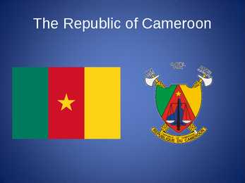
The Republic of Cameroon Cameroon · A unitary republic of central and western Africa · Bordered by Nigeria to the west; Chad to the northeast; the Central African Republic to the east; and Equatorial Guinea, Gabon, and the Republic of the Congo to the south. · Cameroon's coastline lies on the Bight of Bonny, part of the Gulf of Guinea and the Atlantic Ocean. · The country is called "Africa in miniature" for its geological and cultural diversity. History · The territory of present day Cameroon was first settled during the Neolithic · Portuguese sailors reached the coast in 1472
project. Available space analysis On the schematic site plan of the Northern Pointe site, a total area of some 200 feet by 450 feet is indicated as the proposed maximum extent of below grade development. In addition, we believe that a 345 feet by 475 feet area to the north of the community center may be considered for future inclusion in Northern Pointe development plans, although it is not under consideration in this study. Preservation of thirtyone major trees identified in the northeast corner of the site would significantly reduce the total space available for development. It is recommended that the soil should remain undisturbed within 25 feet of the perimeter of the trees’ root systems. Consequently, an area of some 185 feet by 320 feet would be excluded from development plans in an effort to preserve the grove of Douglas Fir trees. Preliminary analysis of the site has indicated that it would be feasible to construct three below grade levels
Between the mountain and the viewer there are cumulonimbus clouds, and although they indicate a storm, there is rain on neither Fuji nor the main scene. [21] Boats In the scene there are three oshiokuri-bune, fast boats that are used to transport live fish[22] from the Izu and Bs peninsulas to the markets of the bay of Edo. As the name of the piece indicates the boats are in Kanagawa prefecture, with Tokyo to the north, Mt Fuji to the northeast, the bay of Sagami to the south. and the bay of Tokyo to the east. The boats oriented to the southeast, are returning to the capital. There are eight rowers per boat, clinging to their oars. There are two more passengers in the front of each boat, bringing the total number of human figures in the image to thirty. Using the boats as reference, one can approximate the size of the wave: theoshiokuri-bune were generally between 12 to 15 meters long, and noting
territory (now Oklahoma) 1838.- 1000 escaped in North Carolina mountains Will Thomas adopted cherokee, brought 56000 acres+gave it to cherokees- >eastern cherokees Nation+opened much of their land to white settlers Set up schools, churches.. Late 1800's congress abolished Cherokee Nation 1887.-Dawes Act-> a new ,,Cherokee Nation" disolved. 1954.-cherokee nation recognized as a ,,Federally Recognised Tribe" Today many (most) cherokees live in northeast Oklahoma 1987.-U.S Congress officially recognized ,,Trail of tears National Historic Trial"
River. Almost all the rivers between the mountains flow into the Mississippi. Along the border with Canada, there are five big lakes, called ,,the Geat Lakes". Climate Pacific Ocean moderates west coast temperatures. Mild summers, cool winters, much rain on northwest coast. Warm and dry in summer, mild with some rain rest of the year on California coast. Inland Southwest mostly dry with warm summers and cold winters. Warm summers, cold winters, moderate precipitation on northeast and north-central but warmer. Alaska is extremely cold in winter and has spetacular glaciers. Hawaii is tropical. History Before Columbus came to the New World in 1492, the land were inhabited by Native Americans or Indians. After 1492, there was a struggle for land and domination in the New World. England defeated the Spanish navy in 1588. In 1607, it started its first successful colony in America, called ,,Virginia". That was where Captain John Smith met the beautiful
horisontaalsuunaline liikumine) Gradientjõu suunast põhjapoolkeralt paremale ja lõunapoolkeral vasakule Gradientjõud on tekkinud õhurohkude erinevusest ja paneb õhu liikuma kõrgema rõhuga alalt väiksema rõhuga alale (difusioon) Maapinna hõõrdejõud mõjutab tuule tugevust, hõõrdumise vähenemise tõttu kasvab tuule kiirus kõrguse suurenedes 1. Polar high - Polaarne idatuul 2. Westerlies - Läänetuul 3. Northeast trade winds - Kirdepassaat 4. Southeast trade winds - Kagupassaat 5. Westerlies - Läänetuul 6. Polaarne idatuul Mussoonid ...sesoonsed tuuled - Puhuvad 15-20° kraadide vahel - On tuuled, mis puhuvad suvel ja talvel vastupidistest ilmakaartest - Tekivad maismaa ja mere erineva soojenemise ja jahtumise tõttu - Hästi välja kujunenud Aasia kagu- ja lõunaosas 1. Talvemussoon
Victoria is one of the most densely populated states in Australia. Its capital city is Melbourne and it was named after the British Prime Minister Lord Melbourne. Melbourne is said to be the heart of Australian finance and the headquarters of industry giants. Victoria is more an industry than a tourist state. Queensland is known for its natural riches like huge coalfields, copper, silver, lead. Its capital city is Brisbane, which is the third largest city in Australia. Because it lies in the Northeast part of Australia, its climate is mainly tropical. South Australia is famous as it is the region of fruit farming, vineyards and olive groves. Only the southern coast is fertile, most of the state is arid. Its capital is Adelaide, which is known for the Adelaide circuit. Western Australia is the biggest state in Australia. It is rich in deserts, as the central part of the state is practically a desert in whole and nearly uninhabited. On the other hand, the desert
west south from the Northwest Territories at 60°N until it reaches the Continental Divide at the Rocky Mountains. The province extends 1,223 kilometres north to south and 660 kilometres east to west at its maximum width. Its highest point is 3,747 metres at the summit of Mount Columbia in the Rocky Mountains along the southwest border, while its lowest point is 152 metres on the Slave River in Wood Buffalo National Park in the northeast. Alberta contains numerous rivers and lakes used for swimming, water skiing, fishing and a full range of other water sports. There are three large lakes and a multitude of smaller lakes less than 260 square kilometres each. Lesser Slave Lake (1,168 square kilometres) is northwest of Edmonton. The longest river in Alberta is the Athabasca River which travels 1,538 kilometres from the Columbia Icefield in the Rocky Mountains to Lake Athabasca.
Canada is politically a young country. In 1967 the people celebrated its first century of independence. It was on the first of July, 1967, that four provinces of British North America joined together and formed the Dominion of Canada. Geographical facts. Canada occupies the northern portion of North America. It shares land borders with the United States to the south and with Alaska to the northwest. It shares territorial water boundaries with the United States, Greenland to the northeast, and Saint-Pierre and Miquelon (an overseas community of France) to the southeast. Canada stretches from the Atlantic Ocean in the east to the Pacific Ocean in the west. To the north lies the Arctic Ocean. The most densely populated part of the country is the Quebec City-Windsor Corridor in the east. This part is thinly soiled, rich in minerals, and dotted with lakes and rivers--over 60% of the world's lakes are in Canada. Canada is rich in lakes and rivers
incomes. Corporate income tax is also 26% but comes only from profit so nothing is deducted from wages/salaries. Value added tax is the country's main income. It is not noticeable as it is already added to prices and no papers have to be filled. Economy. Estonia is not rich in mineral resources. The main natural resources are: building materials such as clay, sand, gravel, dolomite, oil shale, phosphorite and peat. Oil shale is mined in the northeast (Kohtla-Järve) and it is used as fuel in thermal power stations. Dolomite is found in Saaremaa. Economy is primarily based on light industry and the service sector i.e. tourism, banking, trade, textile and sewing industries give work to many people. Paper and timber industries also employ many workers. Paper was first produced in Estonia in 1677 and it has retained its important role. Estonian furniture industry has also a long tradition
............................................................................................................................ 9 2 Introduction Jamaica is an island nation of the Greater Antilles, 234 kilometres (146 mi) in length and as much as 80 kilometres (50 mi) in width situated in the Caribbean Sea. It is about 620 kilometres (385 mi) northeast of the Central American mainland, 145 kilometres (90 mi) south of Cuba, and 190 kilometres (120 mi) west of the island of Hispaniola, on which Haiti and the Dominican Republic are situated. Its indigenous Arawakan-speaking Taíno inhabitants named the island Xaymaca, meaning either the "Land of Springs," or the "Land of Wood and Water". Formerly a Spanish possession known as Santiago, it later became the British West Indies Crown colony of Jamaica. It is the third most populous anglophone
JOHNNY CASH Semester Powerpoint By: Nicole Casaday Biography Walking a Line in His Shoes February 26, 1932 in Kingsland, Arkansas; the one and only Johnny Cash was brought into a loving family of nine created by Ray and Carrie Rivers Cash. Johnny and his family lived In Kingsland until he was at the age of three, where they then moved to Dyess, Arkansas; a Colony in Northeast Arkansas. The Cash family farmed nearly 20 acres filled of cotton, there Ray, Kerry and all seven of their children worked side by side in the crops; including little Johnny. Johnny as a Kid... Cash spent his childhood in Guns & Girls Dyess Colony until he graduated high school in 1950, where he then fled off to D e t r o i t in search of work only to find himself in Pontiac, Michigan working in the automotive business. However, Cash soon after enlisted in the U.S
east of Europe. To the east the country borders Russia. Latvia is the countries neighbour to the south. From the west the coast of Estonia is washed by the Baltic Sea and from the north by the Gulf of Finland. The length of the coastline is approximately 3 800 km. The longest distance from east to west is 350 km, while north to south Estonia stretches 240 km. THE NAME The name EESTI was apparently derived from the word AISTI, the name given by ancient Germans to the peoples living northeast of the Vistula River. Tacitius, the Roman historian, was the first one to mention it (AESTI), while the Arab scholar alIdrisi was the first one to mark it on a map (as ASTLANDA). To the ancient Scandinavians the land was known as EISTLAND; to modern Scandinavians it is known as ESTLAND. Most contemporary languages use the Latin name ESTONIA. FLAG The Estonian blueblackandwhite national flag was originally the flag
The country also includes several major islands, including Baffin, Ellesmere, Victoria, Newfoundland, and Melville, and many small ones. Its border with the U.S., the longest border in the world not patrolled by military forces, extends 8,890 km. 3. Mountains, lowlands Canada's vast area means it has many varying types of terrain, much of which is mountainous. The Cordillera in the west, the Appalachians in the southeast, the mountains of northern Labrador and of Baffin Island in the northeast, and the Innuitian Mountains in the north form its high edge. A large interior basin centred on Hudson Bay and covering nearly four-fifths of the country is composed of the Canadian Shield, the interior plains, and the Great Lakes St. Lawrence lowlands. Canada's highest peak is Mount Logan (5,959 m) in Yukon Territory. 4. Rivers, lakes With less than 1 percent of the world's population, Canada has some one-seventh of the world's supply of accessible fresh water
Sometimes Australia is called the Island Continent. There is a great reason why. It really is an island. It is 2880 km from the mainland of asia and is almost half way round the world from Europe. More that 9600 km separate it from America. Australia lies between the Pacific and Indian oceans. The Timor sea and the Arafura sea separate Australia from Indonesia. In the north the coast is washed by Great Australian Bight and the Indian ocean. In the northeast the Coral sea washes the coasts and in the southeast there is the Tasman sea which also separates Australia from New Zealand. The biggest island is Tasmania which is located in the south of the country. Waterbodies There are very few rivers in Australia. Australian temporary rivers are called the creeks they are full only after it rains. The biggest rivers are in the east. Most of them are very short. The Murray river with its tributary the Darlinggives water for irrigation
Great Britain and over 790 surrounding islands and archipelagoes. Scotland's only land border is with England, which runs for 96 kilometres (60 mi) in a northeasterly direction from the Solway Firth in the west to the North Sea on the east coast. Separated by the North Channel, the island of Ireland lies 30 kilometres (20 mi) from the southwest tip of the Scottish mainland. Norway is located 305 kilometres (190 mi) to the northeast of Scotland across the North Sea. The Atlantic Ocean, which fringes the coastline of western and northern Scotland and its islands, influences the temperate, maritime climate of the country. The topography of Scotland is distinguished by the Highland Boundary Fault a geological rock fracture which traverses the Scottish mainland from Helensburgh to Stonehaven. The faultline separates two
Today, a rapidly declining 10 percent of the Chinese population is below the poverty line. 90.9% of the population is literate, [63] compared to 20% in 1950.[64] The life expectancy in China is the third highest in East Asia, after Japan and South Korea. There is a large wealth disparity between the coastal regions and the remainder of the country. To counter this potentially destabilizing problem, the government has initiated the China Western Development strategy (2000), the Revitalize Northeast China initiative (2003), and the Rise of Central China policy (2004), which are all aimed at helping the interior of China to catch up. China is undergoing major reforms in its financial sector, which has been plagued by nonperforming loans made in the 1980s and early 1990s to inefficient state-owned enterprises. The government has spent five years and more than US$400 billion cleaning bad loans off the books of the big four state-owned banks, helping prepare them to become
Uluru One of the most beautiful things in Australia is Uluru (Ayers Rock) in the outback. It is an enormous rock alone in the middle of the desert. It is three kilometers long and 348 metres high. There is another 2000 meters under the ground. Uluru is 600 000 000 years old and it is the largest rock in the world. The Great Barrier Reef. One of the natural wonders of the modern world is the Great Barrier Reef. It is located off the northeast coast of Australia. It is the biggest coral reef in the world extending 2000 kilometers along the coast of Queensland. It consists of more than 600 coral islands. Some of them are true coral islands, other are the tops of submerged mountain ranges covered with lush tropical growth. Most of the islands are inhabited and many of them have been developed as tourist resorts. Scientists estimate that the reef is more than thirty million years old. It had its beginning as a
Geographical position: Australia is located in the Southern Hemisphere and it's the smallest continent in the world. It's the only continent except for Antarctica that lies all south of the equator. It is surrounded by the Indian Ocean and the Pacific Ocean; the Gulf of Carpentaria, the Coral Sea, the Tasman Sea, the Australian Bight, the Timor Sea and Shark Bay. The Great Barrier Reef is one of the natural wonders of the modern world. It is located off the northeast coast of Australia. It's the largest coral reef on earth, extending for 2000 kilometres along the coast of Queensland. It consists of more than 600 islands. Most of the islands are uninhabited, but some have been developed as tourists resorts. Scientists estimate that the Reef is more than 30 millions years old and it had it beginning in a tiny animal known as polyp. There are more than 300 varieties of coral, which is a ultimate dream of every shell- collector
11 crisis. The country is the first former member of the Comecon to achieve the status of a developed country according to the World Bank (2006) and the Human Development Index (2009), which ranks it as a "Very High Human Development" nation. The Czech Republic Ceská republika short form Cesko is a country in Central Europe.The country borders Poland to the northeast, Germany to the west and northwest, Austria to the south and Slovakia to the east. The Czech Republic has been a member of NATO since 1999 and of the European Union since 2004. The Czech Republic is also a member of the Organization for Security and Cooperation in Europe (OSCE). As an OSCE participating State, the Czech Republic's international commitments are subject to monitoring under the mandate of the U.S. Helsinki Commission. From 1 January 2009 to 1 July 2009, the Czech
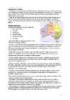
2.2.2 Geography Location: Eastern Europe, bordering the Baltic Sea and Gulf of Finland, between Latvia and Russia Area: total: 45,228 km2 land: 42,388 km2 and water: 2,840 km2 Coastline: 3794 km Climate: maritime; wet, moderate winters, cool summers Terrain: marshy, lowlands; flat in the north, hilly in the south Land use: arable land: 12.05%, permanent crops: 0.35%, other: 87.6% (2005) Environment current issues: air polluted with sulfur dioxide from oilshale burning power plants in northeast; however, the amount of pollutants emitted to the air have fallen steadily, the emissions of 2000 were 80% less than in 1980; the amount of unpurified wastewater discharged to water bodies in 2000 was 1/20 the level of 1980; in connection with the startup of new water purification plants, the pollution load of wastewater decreased; Estonia has more than 1,400 natural and manmade lakes, the smaller of which in agricultural areas need to be monitored;