Leidsid 33 sarnast õppematerjali, mis on seotud failiga "The Chiltern Hills". Need materjalid aitavad sul teemat sügavamalt mõista.
hills, chalk, roman, englandtect, south, east, north, cover, woods, wild, ancient, flint, localvide, beauty, year, known, lying, miles, west, four, scenery, interesting, begin, thames, valley, through, comprise, variety, wildlife, times, ridgevided, relatively, safe, easily, across, southern, iron, thus, comes, tribe, early, saxon, periodThe United Kingdom The United Kingdom consists of England, Scotland, Wales and North Ireland and it is situated in the Atlantic Ocean near the mainland of Europe. The population of the UK is 58.6 million and area is 244,110 sq km. Britain has a temperate humid climate. Its characteristic features are mild winters, warm summer, no temperature extremes, abundant rain all year round and frequent changes of weather. The mild climate is partly due to the warm Gulf Stream and partly to the south westerly winds. Occasional winds from the east in winter may
FACTFILE Area: 45 228 sq km Poplulation: under 1.4 million Capital: Tallinn Language: Estonian Currency: Eesti kroon (EEK) Main religion: Lutheran National holiday: 24 February (anniversary of the republic) National flower: Cornflower National bird: Barn Swallow National stone: Limestone LOCATION The Republic of Estonia is the northernmost and smallest of the three Baltic States. It is located on the eastern shores of the Baltic Sea in the north east of Europe. To the east the country borders Russia. Latvia is the countries neighbour to the south. From the west the coast of Estonia is washed by the Baltic Sea and from the north by the Gulf of Finland. The length of the coastline is approximately 3 800 km. The longest distance from east to west is 350 km, while north to south Estonia stretches 240 km. THE NAME The name EESTI was apparently derived from the word AISTI, the name given by ancient Germans to the peoples living northeast of the Vistula
'ledsltv 'sembl/ seadusandlik kogu The British Isles is the name of a group of islands washed by the North Sea in the east and the Atlantic Ocean in the west. The British Isles are shared by two separate and independent countries: the
Report of SCOTLAND Maiki Joakit 10. klass 2008 Etymology Scotland is from the Latin Scoti, the term applied to Gaels. The Late Latin word Scotia (land of the Gaels) was initially used to refer to Ireland. By the 11th century at the latest, Scotia was being used to refer to (Gaelic-speaking) Scotland north of the river Forth, alongside Albania or Albany, both derived from the Gaelic Alba. The use of the words Scots and Scotland to encompass all of what is now Scotland became common in the Late Middle Ages. History Repeated glaciations, which covered the entire land-mass of modern Scotland, have destroyed any traces of human habitation that may have existed before the Mesolithic period. It is believed that the first post-glacial
7. What are the symbols of the 4 constituent countries? England- The three national symbols of England are St.George's cross; The red Rose and the Three Lions Crest; The oak is national tree; Northen Ireland- Shamrock; St.Patrick ;Scotland-thistle, St.Andrew 's cross . ; Wales-daffodil, leek, Prince of Wales's feathers; St.David, red dragon 8. How did the Romans influence Britain? The Romans built the first bridge(in London), the capital(London) is a Roman city, the street system(paved roads), benefits for the poor, public heated baths, art, architecture. They also influenced the language (pound, butter, cheese, wine, candle). 9. Which areas of life is English used in? technology, science, politics, tourism, aviation 10. Which languages influenced the Old English (until the 10th century) most?Anglo-Saxon, Celtic(the Celts), Scandinavian languages (Norse and Danish), Latin (the Romans) 11
Stonehenge was probably built to mark the longest and shortest day of the year because it lies on the line of the midsummer sunrise and the midsummer sunset. That would have enabled people to keep a record of changing of seasons. Although it is still unclear who built it. Hadrian’s Wall is an ancient wall which was built in 2nd century by Hadrian, the emperor of Rome from AD 117 to 138, and it marked the northern border of the Roman Empire in Britain. The wall was 80 Roman miles (117 kilometres) long and it is situated in northern Great Britain and stretched from Solway Firth in the west to the Tyne River near Newcastle in the east. It was built to keep the Caledonians of Scotland out of England. Windsor Castle, which is one of the official residents of British monarch, is located in the English country of Berkshire. It is the largest in habited castle in the world and the oldest in continuous occupation, since it dates back to the time of William the Conqueror
Project ESTONIA MAP OF ESTONIA Southern Viljandimaa The southern part of Viljandi county catches the eye with its sublime scenery. The area today lies in the very heart of the historical Mulgimaa the home of hills, deep valleys and lakes brought together by a beauty spot Halliste primeval valley. According to several folk tales, it is also in these valleys, woods and bogs that Old Nick found refuge.The great variety displayed in the nature is also reflected in the local cultural heritage. At the beginning of the 19th century growing linen spread and became the basis of the legendary wealth of Mulgi farms. The ancient barn-dwellings and decaying manor houses are the mute witnesses of those times. The riches and cultural heritage of Mulgimaa owe to the diligence and tenacity of the local people. Village handicraftsmen and masters have always been honoured
Geography Canada is the world's second largest country in total area after Russia , since it covers nearly 10 million square kilometres, but is one of the most sparsely populated, with only about 34 million inhabitants. The majority of them live within 300 kilometres of Canada's southern border. Much of the rest of Canada is uninhabited or thinly populated, because the country has a rugged terrain and severe climate. Canada extends across the continent of North America, from Newfoundland on the Atlantic coast to British Columbia on the Pacific coast and northward into the Arctic Ocean. Canada shares land borders with the United States to the south and north-west. Canada is a land of great variety. Towering mountains, crystal-clear lakes, and lush, green forests make Canada's far west a beautiful region. Farther inland, fields of wheat and other grains cover Canada's vast prairies
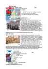
THE CITY OF LONDON History The City of London occupies one square mile in the middle of the capital. It once made up entire town of London, surrounded by the wall first built by Romans. The Romans also built a bridge over the Thames and there has been one in the same area ever since. The Roman Londinium grew up on the northern side of the bridge. In AD 61 the native Celtic tribe, led by Queen Boudicca, rose up against the Romans. They burnt down Londinium to the ground and killed most of its inhabitants. Roman armies eventually defeated Boudicca and Londinium was rebuilt. At the end of the fourth century AD the Roman Empire began to crumble and the Roman armies were recalled from Britain to defend Rome itself. Once they had left, tribes such as Angles,
Its geography is very diverse ranging from moist rainforests to dry deserts and bald mountain peaks. There are two big mountain ranges, one of them is the Rocky Mountains and the other is The Appalachian Mountains. The Capital of The USA is Washington D.C. Other big and famous cities are New York, Los Angeles, Houston, Chicago and Las Vegas. The national anthem of the United States is "The Star-Spangled Banner", with lyrics written in 1814 by Francis Scott Key. There are 6 time zones. From east to west they are: Eastern Standard Time, which is 5 hours behind Greenwich Time, Central Standard Time, Mountain Standard Time, which is 7 hours behind Greenwich Time, Pacific Standard Time. Alaska and Hawaii have their own time zones: Alaska Standard Time and Hawaii Standard Time. Geographical Position The USA lies in the Northern Hemisphere in North America. It covers a big part of the continent and is also the third largest country in the world
Scotland ! Scotland (Gaelic: Alba) is a country in northwest Europe that occupies the northern third of the island of Great Britain. It is part of the United Kingdom, and shares a land border to the south with England. It is bounded by the North Sea to the east, the Atlantic Ocean to the north and west, and the North Channel and Irish Sea to the southwest. In addition to the mainland, Scotland consists of over 790 islands including the Northern Isles and the Hebrides. Edinburgh, the country's capital and second largest city, is one of Europe's largest financial centres. It was the hub of the Scottish Enlightenment of the 18th century, which saw Scotland become one of the commercial, intellectual and industrial powerhouses of Europe. Scotland's largest city is Glasgow, which was once one of the
* it covers 243,610 sq km * everybody from the UK is called British * the capital city is London * is made up of four constituent countries: England, Scotland, Wales and Northern Ireland which in turn are divided into counties * the flag is called the Union Jack which is a combination of the flags of England, Scotland and Northern Ireland * the population is about 60,000,000 people, the population density is 242 people/sq km * its coasts are washed by the Atlantic Ocean, the North Sea, the English Channel, the Celtic Sea, Saint George's Channel, and the Irish Sea. It is linked to France by the Channel Tunnel * the United Kingdom is a constitutional monarchy. The current monarch is Queen Elizabeth II, who is also the Queen and Head of State of fifteen other Commonwealth Realms, such as Canada, Australia, New Zealand and Jamaica. England: * it has 50 cities, the capital city is London
Australia Fact file: Australia comprises a land area of 7 686 850 square kilometres. Its population is about 21,3 million people. Australia's capital is Canberra. The national language is English. The official name of it is the Commonwealth of Australia. It's divided into six states and two territories: New South Wales, Queensland, South Australia, Western Australia, Tasmania, Victoria, Australian Capital Territory (ACT) and Northern Territory. Symbols: Australia had the British flag as their official flag until 1901, when the Commonwealth of Australia was formed. Over 30 000 entries attracted the official competition. Five of them, which contained almost identical designs, were placed equally first. The Australian flag symbolises Australia's historical links with Britain, because it has
A.D., it is more accepted by historians that the Romans were the first. The settlement was called Londinium. The first London lasted for just seventeen years, for around AD 61, a tribe of Celts led by Queen Boudica stormed London, burning it to the ground. The next heavily-planned London prospered and surpassed Colchester (another major city at the time) as the capital of the Roman province of Britannia. At its height in the 2nd century, Roman London had a population of about 60,000. However, by the 3 rd century, the city fell into a decline due to trouble in the Roman Empire and by the 5th century, it was largely abandoned. But, under the control of various English kings, London once again prospered as an international trading centre. However, Viking raids began in the late 10 th century and reached a head when they took the city under Danish king Canute and forced the then-English king to flee.
Tallinn English College Report of Canada 8a Teacher: Merike Sisask Composer: Kärt Kalvet 2010 Canada, Kärt Kalvet 8a Canada General Information Canada is in North America. It's area is 9220970 sq km. Canada's population is 313.612.000 people. Canada is divided into 10 provinces and 3 territories. The capital of Canada is Ottawa. Canada has constitutional monarchy. The head of state in Canada's government is the Queen of England. There are two main languages in Canada: English and French. Canada's curreny is Canadian dollar (1 dollar=100 cents[Can$]). The highest peak of Canada is Mount Logan, 5959 metres. The lowest point is sea level
What kind of climate do you think Britain has? What is its surface like? What countries are situated on the islands? Which country are we going to study? Why? Location Land and climate affect life in every country. Britain is no exception. Britain is the largest island of the British Isles 1. It is just under 1,000 km long and just under 500 km across in its widest part. Britain is separated from the mainland of Europe by the North Sea on the east and the English Channel on the south – by only about 35 km of water at its closest point (the Strait of Dover 2). Most of the coastline is so broken by bays and inlets that no point on the island is more than 120 km from the sea. Climate and Surface Britain has a mild climate which is influenced by the Gulf Stream, an ocean current which flows past the British Isles and brings warm water from the Gulf of Mexico
............................................9 12. References....................................................................................................10 Introduction I chose finland because there are friendly people and beautiful nature. Finland is bigger than Estonia. There lives over 5 milj. people. Finland capital is Helsingi and there lives about 2 milj. people. Highest top is 1328m. Finland is bordersed with Sweden to the west, Russia to the east and Norway to the north. It is the eight largest city in Europe. Most Finns speak Finnish. The second language is Swedish. Finland is rated the sixth most peaceful country in the World. In Finland there are more than 60000 lakes. Capital: Helsinki Area: 338145km2 Population: 5200000 Language: Finnish, Swedish Currency: Euro (EUR)
So, Australia is both a country and a continent. If you want to make clear that you are speaking about the country, you may call it the Commonwealth of Australia. It’s the official name of the country. Australia is the smallest continent, but one of the largest countries on Earth. It’s 6th largest country. Its area is about 7.6 million sq km. One third of it is occupied by deserts. It’s both the flattest and, except for Antarctica the driest. Neighbouring countries include Indonesia, East Timor and Papua New Guinea in the north, the Solomon Islands, Vanuatu in the northeast, and New Zealand in the southeast. Its capital is Canberra. Other big cities are Melbourne, Sydney, and Brisbane. National language in Australia is English. Monetary unit is Australian dollar. Their national holiday is on the 26th of January. In 1788 on the 26th of January the first fleet arrived at Botany Bay and established a penal colony near modern-day Sydney. Geographical Position
nationalities. Besides English and French there are also immigrants from Scotland, Ireland, Wales, Germany, Ukraine and Scandinavia. In Edmonton and Calgary there are also historic Chinatowns, and Calgary has Canada's third largest Chinese community. Geographical features Alberta covers an area of 661,848 square kilometres, an area about 5% smaller than Texas or 20% larger than France. This makes it the fourth largest province after Quebec, Ontario, and British Columbia. To the south, the province borders on the 49th parallel north, separating it from the U.S. state of Montana, while on the north the 60th parallel north divides it from the Northwest Territories. To the east the 110th meridian west separates it from the province of Saskatchewan, while on the west its boundary with British Columbia follows the 120th meridian west south from the Northwest Territories at 60°N until it reaches the Continental Divide at the Rocky Mountains.
history of the City and of Scotland itself. It was described by Daniel Defoe as the "Largest, Longest and Finest Street in the World" Edinburgh Castle Edinburgh Castle sits on top of what was, at one time, a volcano - a 437 feet high plug of basalt rock. The shoulder of the Royal Mile runs east down from the castle and was formed when the whole of Scotland was covered by an ice sheet and the flow of the glacier ran from west to east - dropping rubble and earth in the lee of the rock. It has been used as a
London History The Romans AD 43- AD 410 The Romans finally invaded Britain in AD 43 from Kent. The Romans lead by Julius Caesar attempted to invade Britain twice before that in 55 and 54 BC but the invasions were unsuccessful. They made their way to the river Thames and sailed up it. The Romans knew it was important to control a crossing point at the river Thames, so they decided to build a settlement on the north bank. Although small settlements had been built on the banks of the Thames, the Romans were the ones who built the first city. They called their city Londinium. The Roman engineers noticed that the point where the swampy river narrowed would make an ideal crossing point, they built London Bridge. Less than 20 years later the native Iceni tribe, led by Queen Boudicca, rose up against the Romans in revenge for mistreatment and burnt Londinium to the ground
One of the mysteries is how it was built at all with the technology of the time. Another is its purpose. It appears to function as a kind on astronomical clock and we know it was used by the Druids for ceremonies marking the passing of the seasons. It appears in number of novels. These days it is not only the interest of tourists but is also a gathering point of certain minority groups. It is now fenced off to protect it from damage. 3. The Roman conquest Julius Caesar's first raid was in 55 BC but the romans left. Ad 43- the Romans came to stay. The army established Roman rule in the south and SW of the country. The Romans started to introduce their laws to a new province of the Roman Empire and started to build good roads. Officials were appointed (governors, procurators to collect taxes, look after the estates and mines and se that the gold, silver, iron and lead were exported back to Rome). Introduced schools,a new language
Labour Party, the Liberal Party and National Party. The Senat's membership is wider, it comprises 12 senators from each state and 2 from each territory. Senators are elected for six year terms. The Executive power in Australia is in the hands of the Commonwealth Government lead by the Prime Minister. Today the Prime Minister is John Howard, the leader of the Liberal Party. History Australia was once a part of the giant continent Gondwana. It included Africa, South America and Antarctica. First Australia and Antarctica split from Gondwana, then Australia broke away from Antarctica and began to move north. Aborigines arrived there about 50 000 years ago. They had occupied the whole continent by 30 000 years ago. At that time Tasmania was still part of the mainland. About 20 000 years ago the ice began to melt and the rising water level cut Tasmania off from the mainland. Traders from what is now Indonesia are thought to have been visiting
and it is bordered by three oceans: the Arctic, the Pacific and the Atlantic Oceans. The population of Canada is about 31 million people. About 77% of the people live in cities which lie in a band about 100 miles wide above the border of the United States. The capital of Canada is Ottawa. Other large cities are Montreal, Toronto, Vancouver, Winnipeg and Quebec. 2. Geographical position Canada is a huge country in the continent of North America. It is bordered with the Atlantic Ocean in the east, the Pacific Ocean in the west, the United States of America in the south and the Arctic Ocean in the north. Canada is a vast country, with a territory of 3.8 million square miles of land and fresh water it is the second biggest country in the world after Russia. Canada covers most of the northern part of North America. Canada has over 151,480 miles of coastline
cultural diversity of different nations in Canada. All the communities living in the country are encouraged to remember their origins and hold their own ethnic events and national festivals. Cultural diversity makes Canada even more interesting. In spite of this, in recent years there is a strong movement in French-speaking Quebec to become an independent country. There are many different native people throughout Canada like the Crees, Mohawks, Troquois and Sioux. In the north of the country, the Inuit (Eskimos) now have a self-governing homeland called Nunavut, meaning our land. It is over two million square kilometers and it is inhabited by 17,500 Inuits. The national symbol of Canada is the maple leaf. The national tree is the maple. Canada is also the most tolerant societies in the world because only 13% of Canadians say that they would object their children marrying somebody of a different race, compared with 32% in the USA.
span required, the materials at hand, and the type of load anticipated - pedestrian, vehicular, railroad, or a channel of water as in aqueducts. Primitive bridges Other than the clapper bridges of England and similar spans surviving in other countries, bridges dating from prehistoric periods are rare. Bridges of twisted vines and creepers found in India, Africa, and South America, the ancient cantilevers of China, Kashmir, and Japan, if any survive, or the wooden arches of Japan may be candidates for World Heritage listing because they perpetuate primitive ingenuity and craft technology that is important to recognize. Since some of their materials cannot be original, these structures will have to pass the test of authenticity. In 51 BC, during the Gallic War, Caesar attested to the construction of narrow wooden bridges by
Introduction The aim of this research is to get know more about the Netherlands history and its geographical facts. This report is describing one of most the most beautiful countries in the Europe - Netherlands. Netherlands is famous for its windmills and flowers. Netherlands is also known unofficially as Holland. Government is constitutional monarchy of north-western Europe. Netherlands is bordered on the north and west by the North Sea, on the east by Germany and on the south by Belgium. The European portion of the Netherlands has a total area of 41,528 sq km of which 33,939 sq km is land surface. Country's capital and largest city is Amsterdam. Population is about 16 million. 3 Chapter 1 The Netherlands 1.1 Mainly about the Netherlands Netherlands is also known unofficially as Holland
officially the Portuguese Republic, Portuguese: República Portuguesa) is a country located in Southwestern Europe, on the Iberian Peninsula. It is the westernmost country of mainland Europe, and is bordered by the Atlantic Ocean to the west and south and by Spain to the north and east. The Atlantic archipelagos of the Azores and Madeira are Portuguese territory as well. The country is named after its second largest city, Porto, whose Latin name was Portus Cale. SETTLEMENT The land within the borders of the current Portuguese Republic has been continuously settled since prehistoric times
Topic Australia Tallinn English College 2006 Australia 1 . Introduction The name Australia is derived from the Latin Australis, meaning of the south. In land area, Australia is the sixth largest nation, its territory is 7,686,850 sq km and its population reaches today over 20,5 million people. It is the only nation to govern an entire continent and its outlying islands. Australia's capital is Canberra, the only city with its own territory. It was built in the early 1900s just to be the capital. The official language is English and the official name of Australia is the Commonwealth of Australia.
The capital city is Washington D.C. Although the United States has no official language at the federal level, English is the de facto national language. English is the most common language for daily interaction among both native and non-native speakers. Spanish is the second language. The largest city is the New York City. The Government is Federal constitutional republic and the president is George W. Bush. 2. Geographical position The United States of America is located on the continent of North America. It has borders with two countries Mexico and Canada. There are also the Atlantic Ocean, the Pacific Ocean and the Gulf of Mexico surrounding the big country. There are 50 states in America. Most of the people live in towns. The biggest state is Alaska; next by size are California, Alaska and Montana. Six states - Maine, Vermont, New Hampshire, Connecticut, Rhode Island and Massachusetts are called New England. They are all small states in the USA that lie in the north- east
The Saxons & Vikings Fragmentary knowledge of England in the 5th & 6th centuries comes from the British writer Gildas, the Anglo-Saxon Chronicle, saints' lives, poetry, archaelogical findings and place- name studies. British landlords ruled small, unstable kingdoms and continued some Roman traditions of governance. In the mid-5th cent, Vertigern, a British leader, hired Germanic mercenaries to help defend against peoples of the north (Picts & Scots). In the end they revolted & the process of invasion and settlement began. The first Saxon ,,kings" were Hengist & Horsa in Kent, Aelle in Sussex, Cerdic / Cynric in Wessex. So the first ,,English" became mainly from Northern Germany & Denmark. The resistance of the Celts was long. They were free at the time, not like other Roman provinces on the Continent. Around 500, the Britons seem to have won several victories. One of their leaders was
Wales. There is little or no direct evidence revealing the construction techniques used by the Stonehenge builders. It was probably associated with sun-worship and other rites of prehistoric people. It appears to function as a kind of astronomical clock. Conceivable reports and implications about a secret government conspiracy, which seeks to hide the irrefutable evidence of extraterrestrial origins. 8. The Roman Conquest. Julius Caesar’s first raid was 55 BC. In 43 the Emperor Claudius launched a full- scale invasion, army of 40,000 men. Permanent Roman rule was established in south and south-west of the country as a consequence. Forts were built in Wales, but the local tribes were difficult to subdue. Hadrian ordered to build the Hadrian’s Wall in 121 or 122, a 117km wall from sea to sea, to protect their territory from the Scots.
Tallinn 2008 1. Introduction Estonia is a small country about the size of Switzerland, or New Hampshire and Massachussetts combined. Estonia is named after the people called "Ests" who lived in the region in the 1 st century AD. The Republic of Estonia is one of the three countries commonly known as the "Baltic States". The other Baltic States are Latvia and Lithuania. 2. Geographical position Estonia is situated in northeastern Europe. Estonia is bounded on the north by the Gulf of Finland, on the east by Russia, on the south by Latvia and on the west by the Baltic Sea. In the north it borders on Finland. The coastline of the Baltic Sea in Estonia is characterized by numerous gulfs and bays, the biggest of them being the Gulf of Finland, the Gulf of Riga and the Gulf of Pärnu. Bays include the Narva Bay, Matsalu Bay, Kolga Bay, Kunda Bay, Tallinn Bay etc. Estonia has over 1500 islands, the largest being Saaremaa and Hiiumaa, Muhu and Vormsi.