Leidsid 33 sarnast õppematerjali, mis on seotud failiga "Recreational use of Pärnu river (essee)". Need materjalid aitavad sul teemat sügavamalt mõista.
river, land, flood, here, there, meanain, soomaa, basin, tourism, farm, floods, spring, soil, situated, near, biggest, activities, forests, alongant, bank, grow, case, these, trees, fish, wildlife, different, species, rivers, emajõe, 9740, above, maximum, precipitation, local, known, april, season, rich, järva, county, phosphorus, total, amountOceans. The population of Canada is about 31 million people. About 77% of the people live in cities which lie in a band about 100 miles wide above the border of the United States. The capital of Canada is Ottawa. Other large cities are Montreal, Toronto, Vancouver, Winnipeg and Quebec. Canada has two official languages English and French. It's interesting to know that about 61% of Canadians name English and 24% French their mother tongue. There are also many other languages spoken in Canada such as: Italian, Chinese, German, Polish, Ukrainian, Greek and Dutch. There are also many native languages such as Algonquian. The British and the French as the main settlers from Europe fought for hundreds of years before they managed to build up a country which was based on recognizing the cultural diversity of different nations in Canada. All the communities living in the
Australia Fact file: Australia comprises a land area of 7 686 850 square kilometres. Its population is about 21,3 million people. Australia's capital is Canberra. The national language is English. The official name of it is the Commonwealth of Australia. It's divided into six states and two territories: New South Wales, Queensland, South Australia, Western Australia, Tasmania, Victoria, Australian Capital Territory (ACT) and Northern Territory. Symbols:
Precipitation (750-1500 mm) is distributed evenly throughout the year. Temperate grassland- Semiarid, continental climates of the middle latitudes typically have between 25 cm and 50 cm of precipitation a year. Much of this falls as snow, serving as reservoir of moisture for the beginning of the growing season. Warm to hot summers are experienced, depending on latitude. In the winter, grassland temperatures can be as low as -40° C, and in the summer it can be as high 20° C. There are two real seasons: a growing season and a dormant season. The growing season is when there is no frost and plants can grow (which lasts from 100 to 175 days). During the dormant (not growing) season nothing can grow because it's too cold. Taiga- Long, cold winters, and short, mild, wet summers are typical of this region. In the winter, chilly winds from the arctic cause bitterly cold weather in the taiga. The length of day also varies with the seasons in the taiga
The capital of Canada is Ottawa. Other large cities are Montreal, Toronto, Vancouver, Winnipeg and Quebec. 2. Geographical position Canada is a huge country in the continent of North America. It is bordered with the Atlantic Ocean in the east, the Pacific Ocean in the west, the United States of America in the south and the Arctic Ocean in the north. Canada is a vast country, with a territory of 3.8 million square miles of land and fresh water it is the second biggest country in the world after Russia. Canada covers most of the northern part of North America. Canada has over 151,480 miles of coastline. Most of Canada's human population lives along its southern border. 3. Relief Canada's geography is very diverse. It has huge lakes, evergreen forests, prairies, meadows and beautiful mountains
Canada's area is about 10 million square kilometers and its population is 31 000 000. Its capital is Ottowa and other main cities are Toronto, Montreal and Vancouver. Almost 75 % of canadians lives within 300 kilometer of the USA border, because the climate is softer in the South. 89 % of Canada is almost unhabited. Its official languages are English and French, but many other languages are spoken too. Like Italian, Chinese, German, Polish, Ukrainian, Dutch and Creek. There are also many native languages such as Algonquian. Most of the canadian's speak English (67 %), but French is very largely spoken too (26 % of the canadians). Canada is based on recognizing the cultural diversity of different nations living in Canada. All the communities living on the country are encouraged to remember their origins and hold their own ethnic events and national festivals. Cultural diversity makes Canada even more interesting.
Topic Australia Tallinn English College 2006 Australia 1 . Introduction The name Australia is derived from the Latin Australis, meaning of the south. In land area, Australia is the sixth largest nation, its territory is 7,686,850 sq km and its population reaches today over 20,5 million people. It is the only nation to govern an entire continent and its outlying islands. Australia's capital is Canberra, the only city with its own territory. It was built in the early 1900s just to be the capital. The official language is English and the official name of Australia is the Commonwealth of Australia.
..............................................................9 Vital waterways for people and wildlife..............................................................................................10 2 Introduction If you were asked to show on a world map the regions with the most biodiversity, your finger would probably end up pointing at the Amazon, the Congo Basin or the island of Borneo. But I chose New Guinea, an island that represents no more than 1% of the world's landmass, an array of extraordinary animals and plants have also flourished, such as tree kangaroos and birds of paradise. Close to 10% of the world's vertebrates are concentrated here, while 7% of the world's higher (vascular) plants grow on the island's productive soils. 3 Geography
Facts and figures 3 Geography 3 Climate 3 Nature 4 History 5 Economy 6 Culture 6 Biggest towns 7 Language 8 3 Facts and figures The Republic of Estonia is a small country. Covering only 45, 228 sq km it is slightly bigger than Denmark, Belgium or Switzerland. Estonia's population is under 1.4 million. The official language is Estonian but since very many Russians live here Russian is also wide spread. The capital of Estonia is Tallinn. The currency used in Estonia is Eesti kroon. The Estonian national flag is blue-black-white. It was originally the flag of the Estonian Students' Society. The flag was first consecrated in Otepää Church in 1884. For a while, during the Soviet occupation, the flag was banned but it was again seen in public in Tartu in May 1988. The national flower is cornflower, the national bird is barn swallow and the national stone is limestone
There is a great reason why. It really is an island. It is 2880 km from the mainland of Asia and is almost half way round the world from Europe. More than 9 600 km separates it from America. Australia lies between the Pacific and Indian oceans. The Timor Sea and the Arafura Sea separate Australia from Indonesia. In the north the coast is washed by Great Australian Bight and the Indian Ocean. In the northeast the Coral Sea washes the coasts and in the southeast there is the Tasman Sea which also separates Australia from New Zealand. The biggest island is Tasmania which is located to the south of the country. 3 Relief Australia is a flat and old continent. Its average height is 274 m above sea level. Its relief is pretty simple – plains cover the greater part of it. Basically one third of its area is covered by deserts and plains. Biggest deserts and plains are: the Great Sandy Desert, the Gibson
coastline is approximately 3 800 km. The longest distance from east to west is 350 km, while north to south Estonia stretches 240 km. THE NAME The name EESTI was apparently derived from the word AISTI, the name given by ancient Germans to the peoples living northeast of the Vistula River. Tacitius, the Roman historian, was the first one to mention it (AESTI), while the Arab scholar alIdrisi was the first one to mark it on a map (as ASTLANDA). To the ancient Scandinavians the land was known as EISTLAND; to modern Scandinavians it is known as ESTLAND. Most contemporary languages use the Latin name ESTONIA. FLAG The Estonian blueblackandwhite national flag was originally the flag of the Estonian Student's Society, consecrated in Otepää Church in 1884. today there is a memorial plaque on the church wall commemorating the event. The Flag Museum attracts tourists who take an interest in the history of the flag.
The Executive power in Australia is in the hands of the Commonwealth Government lead by the Prime Minister. Today the Prime Minister is John Howard, the leader of the Liberal Party. History Australia was once a part of the giant continent Gondwana. It included Africa, South America and Antarctica. First Australia and Antarctica split from Gondwana, then Australia broke away from Antarctica and began to move north. Aborigines arrived there about 50 000 years ago. They had occupied the whole continent by 30 000 years ago. At that time Tasmania was still part of the mainland. About 20 000 years ago the ice began to melt and the rising water level cut Tasmania off from the mainland. Traders from what is now Indonesia are thought to have been visiting Australia well before the 17th century. Chinese, Malaysian and Arab sea Captains may also have landed in Northern Australia after the 15 th century.
Topic Australia Introduction Many people know Australia as the land down under because it is the only continent except for Antarctica that is all on the southern hemisphere. Its name means ,,Southland". The official name of the country is the Commonwealth of Australia. It's capital is Canberra. Australia is the sixth largest country in the world but the smallest continent. Australia has 6 states and 2 territories (New South Wales, Victoria, Tasmania, Queensland, Western Australia , South Australia, The Australian Capital Territory and the Northern Territory).
longer than the rest of mainland Estonia. The climate is maritime and greatly influenced by the Baltic Sea. The area features large bogs, extensive forests, coastal plains, warm and peaceful beaches, the lake Kaali with its mystical meteorite flight and a number of offshore islands. The islanders have their own customs, national costumes and speak their own local dialects. Thousands of birds visit Straitland areas during their spring and autumn migrations. Sights and Tourism Pärnu is the summer capital of Estonia. In summer, the population of forty-four thousand grows tenfold. Its beach, seaside parks, squirrels hopping in the trees, sanatoriums and rest homes, curative sea-mud and holidaymakers are its characteristic features. Pärnu as a summer resort dates back to the 19th century. The first bathing institution started operations in Pärnu in 1838. Pärnu also offers great year-round opportunities for organizing meetings and conferences in addition to
Alberta The capital of Alberta is Edmonton. The population is 3.7 million people and there are many nationalities. Besides English and French there are also immigrants from Scotland, Ireland, Wales, Germany, Ukraine and Scandinavia. In Edmonton and Calgary there are also historic Chinatowns, and Calgary has Canada's third largest Chinese community. Geographical features Alberta covers an area of 661,848 square kilometres, an area about 5% smaller than Texas or 20% larger than France. This makes it the fourth largest province after Quebec, Ontario, and British Columbia. To the south, the province borders on the 49th parallel north, separating it from the U.S. state of Montana, while on the north the 60th parallel north divides it from the
This fact, coupled with the grandeur of the landscape, has been central to the sense of Canadian national identity. 2. Geographical position Canada is the second largest country in the world after Russia. In the Arctic, Canada reaches almost as far north as Greenland. To the south it extends to the same latitude as southern France. The distance from Canada's west coast, the Pacific Ocean, to its east coast, the Atlantic Ocean, is farther than from North America to Europe. Canada's total land area includes thousands of adjacent islands, notably Newfoundland in the east and those of the Arctic Archipelago in the north. In longitude Canada extends from approximately 52° to 141° W, a distance that spans six time zones. In latitude it extends from approximately 42° to 83° N. With its vast Arctic and subarctic territories, Canada is often considered a country only of the far north; however, the peninsula of southern Ontario juts deeply south into the heartland
Australia Australia is the smallest continent in the world. It is 7.6 million square kilometres big. It is often called the island continent because it is rather small for a continent and very big for an island. There are only five countries bigger than Australia in the World. There are five states in the mainland. Tasmania is also considered as a state so there are six states. The Northern Territory and Canberra are also independent but they are not states. Canberra is the capital of Australia and it is situated between Sydney and Melbourne because both of these cities wanted to be the capital. The population is about 19 million people and growing. New South Wales is the most populated state and Victoria is the most densely populated state. The national language is English. It is English because British settlers came to live in Australia in
inhabitants. The majority of them live within 300 kilometres of Canada's southern border. Much of the rest of Canada is uninhabited or thinly populated, because the country has a rugged terrain and severe climate. Canada extends across the continent of North America, from Newfoundland on the Atlantic coast to British Columbia on the Pacific coast and northward into the Arctic Ocean. Canada shares land borders with the United States to the south and north-west. Canada is a land of great variety. Towering mountains, crystal-clear lakes, and lush, green forests make Canada's far west a beautiful region. Farther inland, fields of wheat and other grains cover Canada's vast prairies. Thes fertile farmlands contrast vividly with the Arctic wastelands to the north. Most of the largest towns and industrial areas lie near the Great Lakes and the St Lawrence River in central Canada. In the east, fishing villages and sandy beaches dot the Atlantic coast
Different types of forests and their forms of usage TARTU 2010 Forest A forest (also called a wood, woodland, wold, weald, holt, frith) is an area with a high density of trees. Forests cover approximately 30% of land and 9.4% of all the planet earth. They are also responsible for regulating our planet's climate and act as large purifiers of airs, by absorbing carbon dioxide, and giving out oxygen. Different types of forests Forests are divided into following main types: o Tropical forest o Subtropical forest o Plantations o Boreal forest o Temperate forest o Seasonal or monsoon forest Tropical and Subtropical Forests
It stretches over Eurasia and North America. The taiga is located near the top of the world, just below the tundra biome. The winters in the taiga are very cold with only snowfall. The summers are warm, rainy, and humid. Some of the animals in the taiga hibernate in the winter, some fly south if they can, while some just cooperate with the environment. GrasslandsGrassland biomes can be found in the middle latitudes. They can have either moist continental climates or dry subtropical climates. There are two different types of grasslands; tall-grass, which are humid and very wet, and short-grass, which are dry, with hotter summers and colder winters than the tall-grass prairie. In the winter, grassland temperatures can be as low as -40° F, and in the summer it can be as high 70° F. There are two real seasons: a growing season and a dormant season. Deciduos forest The average annual temperature in a deciduous forest is 50° F. The average rainfall is 30 to 60 inches a year
Every reserve has spectacular examples of geysers, boiling pools, hot springs, boiling mud, volcanic terraces, and craters. Mt Tarawera nearby volcano offers spectacular scenery including superb views inside the rim of the volcano Best area in the country to experience and learn about Maori Culture. Top ten places to visit in New Zealand Bay of Islands Bay of Islands is the finest maritime park in New Zealand. There are about 150 islands. The park has an abundance of marine life, including marlin, whales, penguins and dolphins. Mt Cook National Park Mt Cook and surrounding area is an alpine park within the South Westland World Heritage area. Mt Cook, Mt Tasman and Mt Sefton. This glacier is New Zealand's longest and it has one of longest ski runs in the world. Top ten places to visit in New Zealand Westland National Park
................................8 Culture..........................................................................................................................9 Materials.................................................................................................................... 11 3 Introduction The United States of America is an enormous country. It is the third largest in the world after Russia and Canada. In the USA there are 50 states of which 48 lie together. The population of The USA is about 300 million people. The territory is about 10 million square kilometers. Its geography is very diverse ranging from moist rainforests to dry deserts and bald mountain peaks. There are two big mountain ranges, one of them is the Rocky Mountains and the other is The Appalachian Mountains. The Capital of The USA is Washington D.C. Other big and famous cities are New York, Los Angeles, Houston, Chicago and Las Vegas.
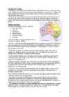
http://www.geo.ut.ee/kooligeo/loodus/rohtlad.htm Temperate Grassland Worksheet 1. Where is temperate grassland situates? Temperate grasslands are located in the mid-latitudes. There are six large areas of temperate grassland: the Pampas in South America, the Veld in Africa, the Canterbury Plains in New Zealand, the Murray-Darling Basin in Australia, the Prairies in North America and the Steppes in Central Asia. 2. Colour the distribution of temperate grassland on the map. 3. How is temperate grassland called in these regions? Eurasia - steppe Hungary - puzda North America - prarie South America - pampa South Africa - veldt 4. What is forest steppe (forest steppe – metsastepp)? A forest steppe is a temperate-climate ecotone and habitat type composed of grassland interspersed with areas of woodland or forest. 5
.................. 59 17.1 Where Do We Get Our Oil?..................................................................................... 59 17.2 What Fuels Are Made From Crude Oil?...................................................................60 17.3 How Does Oil Impact The Environment?................................................................60 3 ENERGY STORY Once upon a time, in a town not far away, there was an 8th grader who was afraid of the dark. Her name was Jules. She was also afraid of the quiet, and of the cold. So she always left on the lights, the TV, and stereo even when she had her I-Pod earbuds on. She took lots of very long, hot showers. She never walked anywhere, but got rides from her mom in a big SUV. She couldn't be happy unless she was using all the energy she possibly could for all the stuff around her. Her friend, Les, didn't like to use any energy at all
It is about 10 million square kilometres and that makes it the second largest country in the world after Russia. Quebec (the province) is six times as big as the UK. Canada borders the Atlantic Ocean, the Pacific Ocean, the Arctic Ocean and the USA. The capital of Canada is Ottawa and other main cities are Toronto, Montreal and Vancouver. It is a very developed country. Montreal is the largest city and it is called the Paris of North America because most of the people there speak French. The population of Canada is 28 million people. It is a very multicultural country. People from many different countries have come to live there. The natives are Eskimos and Indians. Eskimos have their own self-governing homeland called Nunavut. In Canada there are also 2 official languages English and French. One third of the population speaks French and the other two speak English. Many more languages are spoken in that country
language. English is the most common language for daily interaction among both native and non-native speakers. Spanish is the second language. The largest city is the New York City. The Government is Federal constitutional republic and the president is George W. Bush. 2. Geographical position The United States of America is located on the continent of North America. It has borders with two countries Mexico and Canada. There are also the Atlantic Ocean, the Pacific Ocean and the Gulf of Mexico surrounding the big country. There are 50 states in America. Most of the people live in towns. The biggest state is Alaska; next by size are California, Alaska and Montana. Six states - Maine, Vermont, New Hampshire, Connecticut, Rhode Island and Massachusetts are called New England. They are all small states in the USA that lie in the north- east
the majority of rainfall being confined to one season of the year. Savannas can be associated with several types of biomes. Savannas are frequently seen as a transitional zone, occurring between forest and desert or prairie. Although the term savanna is believed to have originally come from a Native American word describing "land which is without trees but with much grass either tall or short", by the late 1800s it was used to mean "land with both grass and trees". It now refers to land with grass and either scattered trees or an open canopy of trees. Changes in fire management Savannas are subject to regular fires and the ecosystem appears to be the result of human use of fire. For example Native Americans created subtropical savannas by periodic burning in
Natural Zones and Flora. There are five distinguishable natural zones in Australia. In the very east there are wet forests (1.) that occupy the space between the Great Dividing Range and the eastern coast. Westward from the Great Dividing Range the wet forests give place to beautiful grasslands with some trees . These grasslands are called the savannas (2.). Farther west the trees disappear and the bushlands (3.) begin. The real desert (4.) occupies the centre of the Western Plateau. In the very southwest there are thin forests of evergreen trees (5.).
Virginia, in the eastern part of the U.S.A. The biggest cities are New York, Washington, Chicago, Los Angeles, San Francisco, etc. The flag of America was adopted on 14 th June 1777. It is called the "Stars and Stripes". It is said that Betsy Ross sewed the first flag. It features 13 horizontal red and white stripes (for the first colonies which formed the U.S.A.) and 50 stars on the blue background. Red means courage, blue justice and white innocence. There is a star for every state of the USA. The official language of the USA is English; Spanish is also widely spoken. The currency of the USA is the United States Dollar. The government of the USA is composed of three coordinate branches: the executive, legislative and the judicial. All the three branches are equal. The executive power is vested in the president, who holds office for a term of four year. At the moment George W. Bush is the president
The official name of the country is the United Kingdom. The United Kingdom is an island country. It consists of the island of Great Britain and Northern Ireland. Great Britain can be divided into three parts England, Wales and Scotland. Each of them has their own capital city. Glasgow in Scotland, Cardiff in Wales and London in England. The country is situated in the north-western Europe. The territory of the United Kingdom is about 244,000 square kilometres and about 60 million people live there. The UK contains a number of small islands. The largest islands that belong to the United Kingdom are the Isle of Man in the Irish Sea and the Isle of Wight which lies off of England's southern coast. The largest groups of islands are the Shetland Islands, the Orkney Islands and the Hebrides. Geographical Position The UK is situated in the Northern Hemisphere. The United Kingdom is bordered by the Atlantic Ocean in the west, the North
diversity. Eco systems, which took millions of years to perfect, are in danger when any species population is decimating. Another example is the destruction of coral reefs in the various oceans, which support the rich marine life. FIND OUT 5 WAYS HOW TO HALT THE LOSS OF BIODIVERSITY 6. Deforestation: Our forests produce fresh oxygen and help in regulating temperature and rainfall. At present forests cover 30% of the land but every year tree cover is lost amounting to the country of Panama due to growing population demand for more food, shelter and cloth. Deforestation simply means clearing of green cover and making that land available for residential, industrial or commercial purpose. FIND OUT 5 WAYS HOW TO STOP DEFORESTATION. 7. Ocean Acidification: It is a direct impact of excessive production of CO2. 25% of CO2 produced by humans
8. Independence 9. Main sights 10. the Czech Republic 11. List of famous people from Prague 12. Geography 13. Weather and climate 14. Population 15. Culture 2 INTRODUCTION The Czech Republic lies at the heart of Central Europe and at its center is the beautiful and historic city of Prague. With a population of some 1.3 million residents, the city lies on either side of the Vltava River in the middle of Bohemia that is one of the three historic Czech territories; the others being Moravia and Silesia. The city has seven "Chapter Divisions" or districts. 3 I read one girl blog and she described Prague so beautifuly. She talked about her adventures. When i was reading that it seemed so real, that i was there to.
Introduction, Location Australia is a country between the Indian Ocean and the Pacific Ocean. It is the only country in the world that occupies an entire continent. The mainland covers an area of 7.7 million km² and it is about 3700 km from the most northern point to its most southern point and about 4000 km from east to west. There are also many different seas around Australia, like the Coral and the Tasman Seas in the west or the Timor and the Arafura Seas in the north, where the Indian and the Pacific Oceans meet. Because all seas and oceans near Australia are warm, surfing is a very popular hobby. Political subdivision Australia is divided into six states, which are: · New South Wales · Victoria · Queensland · South Australia · Western Australia · Tasmania
On account of the country's proximity to the sea, the skies are often cloudy, and rain often falls in the spring and autumn, in the winter the rain turns to snow. The highest point in Estonia is Suur Munamäg It is in fact the highest point in the Baltic region Forest cover over one half of Estonia. The most common types of tree are pine, spruce and birch. Estonia, along with Finland and Sweden are the countries with the greatest percentage of forested land. Forest management and wood production are particularly important for the Estonian economy. One third of Estonian forests are protected areas. In these protected forests you can come across types of primeval forest cover, which have long ago disappeared from other parts of Europe. Examples of such primeval forests are the Järvselja forest in Tartumaa County and Poruni in Ida- Virumaa County. Meadows in Estonia are rich in different species much more so than in Western Europe.