Leidsid 33 sarnast õppematerjali, mis on seotud failiga "Newfoundland and Labador". Need materjalid aitavad sul teemat sügavamalt mõista.
newfoundland, labrador, region, english, tradition, team, triinu, prants, adolfi, location, country, atlantic, province, island, square, canada, mother, tongue, local, musical, heritage, based, irish, scottish, traditions, focuses, strong, hockey, soccer, rugby, landscapeAlberta The capital of Alberta is Edmonton. The population is 3.7 million people and there are many nationalities. Besides English and French there are also immigrants from Scotland, Ireland, Wales, Germany, Ukraine and Scandinavia. In Edmonton and Calgary there are also historic Chinatowns, and Calgary has Canada's third largest Chinese community. Geographical features Alberta covers an area of 661,848 square kilometres, an area about 5% smaller than Texas or 20% larger than France. This makes it the fourth largest province after Quebec, Ontario, and British Columbia
six time zones. In latitude it extends from approximately 42° to 83° N. With its vast Arctic and subarctic territories, Canada is often considered a country only of the far north; however, the peninsula of southern Ontario juts deeply south into the heartland of the United States, and its southernmost point, Middle Island in Lake Erie, is at the same latitude as northern California. The country also includes several major islands, including Baffin, Ellesmere, Victoria, Newfoundland, and Melville, and many small ones. Its border with the U.S., the longest border in the world not patrolled by military forces, extends 8,890 km. 3. Mountains, lowlands Canada's vast area means it has many varying types of terrain, much of which is mountainous. The Cordillera in the west, the Appalachians in the southeast, the mountains of northern Labrador and of Baffin Island in the northeast, and the Innuitian Mountains in the north form its high edge. A large interior basin centred on
Aboriginal people. Beginning in the late 15th century, British and French expeditions explored, and later settled along, the Atlantic coast. France ceded nearly all of its colonies in North America in 1763 after the Seven Years' War. In 1867, with the union of three British North American colonies through Confederation, Canada was formed as a federal dominion of four provinces. It is a bilingual and multicultural country, with both English and French as official languages. Geography: Covering most of the northern part of the North American continent and with an area larger than that of the United States, Canada has an extremely varied topography. In the east, the mountainous maritime provinces have an irregular coastline on the Gulf of St. Lawrence and the Atlantic. The St. Lawrence plain, covering most of southern Quebec and Ontario, and the interior continental plain, covering southern Manitoba
Geography Canada is the world's second largest country in total area after Russia , since it covers nearly 10 million square kilometres, but is one of the most sparsely populated, with only about 34 million inhabitants. The majority of them live within 300 kilometres of Canada's southern border. Much of the rest of Canada is uninhabited or thinly populated, because the country has a rugged terrain and severe climate. Canada extends across the continent of North America, from Newfoundland on the Atlantic coast to British Columbia on the Pacific coast and northward into the Arctic Ocean. Canada shares land borders with the United States to the south and north-west. Canada is a land of great variety. Towering mountains, crystal-clear lakes, and lush, green forests make Canada's far west a beautiful region. Farther inland, fields of wheat and other grains cover Canada's vast prairies. Thes fertile farmlands contrast vividly with the Arctic wastelands to the north
natural gas. In Quebec and Ontario are many manufactories and industries. In the west there is maritime climate and so they fish and ship there. Toronto is the biggest city in Canada, with a population of 5,1 million people. It is followed by Montreal with 3,9, Vancouver, Ottawa (which is the capital of Canada) 800 000 and Quebec with 700 000. Government Canada is a federation of ten provinces (Alberta, British Columbia, Manitoba, New Brunswick, Newfoundland and Labrador, Nova Scotia, Ontario, Prince Edward Island, Quebec, and Saskatchewan) and three territories (Northwest Territories, Yukon, and Nunavut). Formally considered a constitutional monarchy, Canada is governed by its own House of Commons. While the governor-general is officially the representative of Queen Elizabeth II, in reality the governor-general acts only on the advice of the Canadian prime minister. Canada is an independent, self-governing nation. However, Canadians recognize
It is a very developed country. Montreal is the largest city and it is called the Paris of North America because most of the people there speak French. The population of Canada is 28 million people. It is a very multicultural country. People from many different countries have come to live there. The natives are Eskimos and Indians. Eskimos have their own self-governing homeland called Nunavut. In Canada there are also 2 official languages English and French. One third of the population speaks French and the other two speak English. Many more languages are spoken in that country. 75% of the population lives within 300 km of the USA border. Political Structure. Canada is a constitutional monarchy and a Commonwealth Realm that formally recognizes Elizabeth II as Queen of Canada. Though the United Kingdom and Canada share the same Monarch, the Queen of the
Teacher: Merike Sisask Composer: Kärt Kalvet 2010 Canada, Kärt Kalvet 8a Canada General Information Canada is in North America. It's area is 9220970 sq km. Canada's population is 313.612.000 people. Canada is divided into 10 provinces and 3 territories. The capital of Canada is Ottawa. Canada has constitutional monarchy. The head of state in Canada's government is the Queen of England. There are two main languages in Canada: English and French. Canada's curreny is Canadian dollar (1 dollar=100 cents[Can$]). The highest peak of Canada is Mount Logan, 5959 metres. The lowest point is sea level. The longest river is the Mackenzie. The climate and geography of Canada vary greatly from temperate in the south to arctic in the north and from islands and plains in the east to mountains in the west. Location Canada is located in the northern-most region of North America. It's geographical position in co-
the west and to the Arctic Ocean in the North. Canada Covers most of the northern part of North America and its geography is very diverse. Canada's area is about 10 million square kilometers and its population is 31 000 000. Its capital is Ottowa and other main cities are Toronto, Montreal and Vancouver. Almost 75 % of canadians lives within 300 kilometer of the USA border, because the climate is softer in the South. 89 % of Canada is almost unhabited. Its official languages are English and French, but many other languages are spoken too. Like Italian, Chinese, German, Polish, Ukrainian, Dutch and Creek. There are also many native languages such as Algonquian. Most of the canadian's speak English (67 %), but French is very largely spoken too (26 % of the canadians). Canada is based on recognizing the cultural diversity of different nations living in Canada. All the communities living on the country are
Society and culture of english-sspeaking countries Introduction 1. The countries of the world where the English language is spoken. 2. Approximate number of mother tongue speakers of English approximately 350-400 million native speakers. Which place does English occupy in the world by its number of speakers?After which language? English occupies second place by its number of speakers after Mandarin Chinese. 3. What is the difference between English as a Second Language, English as a Foreign Language and English for Specific Purposes? Give examples of situations where they are used. English as a Second Language (ESL or TESL) is a traditional term for the use or study of the English language by non-native speakers in an English-speaking environment. That environment may be a country in which English is the mother tongue (e.g., Australia, the U.S.) or one in which English has an established role (e.g., India, Nigeria)
People can enjoy the sight and the noise of the waters from boats which take them right next to the falls. And to stay dry people receive waterproof clothing. Parts of Canada are very mountainous and the tallest mountain in Canada is the Yukon's Mount Logan, which is 6050 meters tall. Canada has many mountain ranges. In the east there are the Appalachians, Torngats and Laurentias. In the western region there are the Rocky, Coastal and Mackenzie ranges and Mount St. Elias and the Pelly Mountains in the northern regions. Canada has about two million lakes and they cover about 7.6% of Canada's land. The biggest lakes in order by their surface are Lake Huron, Lake Great Bear, Lake Superior, Lake Great Slave (which is also the deepest), Lake Winnipeg, Lake Erie and Lake Ontario. There are also a lot of rivers in Canada. The longest river is the Mackenzie River which is 4241 kilometers long
kilometers and it is bordered by three oceans: the Arctic, the Pacific and the Atlantic Oceans. The population of Canada is about 31 million people. About 77% of the people live in cities which lie in a band about 100 miles wide above the border of the United States. The capital of Canada is Ottawa. Other large cities are Montreal, Toronto, Vancouver, Winnipeg and Quebec. Canada has two official languages English and French. It's interesting to know that about 61% of Canadians name English and 24% French their mother tongue. There are also many other languages spoken in Canada such as: Italian, Chinese, German, Polish, Ukrainian, Greek and Dutch. There are also many native languages such as Algonquian. The British and the French as the main settlers from Europe fought for hundreds of years before they managed to build up a country which was based on recognizing the cultural diversity of different nations in Canada. All the communities living in the
Traditional Inuit way of life was influenced by the harsh climate and stark landscapes of the Arctic tundra from beliefs inspired by stories of the aurora to practicalities like homes made of snow. Inuit invented tools, gear, and methods to help them survive in this environment. Read on to learn more about traditional Inuit ways of life, and how Inuit culture has been changed over the past century. Geography Inuit communities are found in the Arctic, in the Northwest Territories, Labrador and Quebec in Canada, above tree line in Alaska (where people are called the Inupiat and Yupik), and in Russia (where people are called the Yupik people). In some areas, Inuit people are called "Eskimos" however many Inuit find this term offensive. The word "Inuit" means "the people" in the Inuktitut language. Inuit Homes In the tundra, where Inuit communities are found, there are not many building materials. No trees
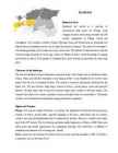
CANADA REVISION QUESTIONS 2010 1. The main physiographic regions of Canada. Canada may be divided into seven physiographic regions: Arctic Lowlands, Cordilleran Region, Interior Plains, Hudson Bay Lowlands, Canadian Shield (Forest Lands), St Lawrence Lowlands and Appalachian Region. Divisions are based on each area's relatively similar physical geography and landforms. Physiographic regionalization is defined here as the process by which regions with relatively homogeneous physical geography are determined 2. Who are the native people of Canada? Into which three groups can they be divided? Canada's constitution specifies three categories of aboriginal peoples: Indian (First Nations), Métis, Inuit. According to Canadian census 2011, 1
................................................................................8 Introduction New Zealand is an island country in the southwest of Oceania. The Tasman sea separates New Zealand from Australia. The basic parts of New Zealand are the North Island and the South Island. Wellington - which is located on the South Island - is the most southern capital city in the world, but the biggest city in New Zealand is Auckland. There are three official languages in New Zealand: English, Maori and the New Zealand's Sign Language. In Maori language the island is also called Aotearoa (which means "Pika Valge Pilve Maa" in Estonian). The Cook Islands and Niue - which are both independent as free accociations - also belong to New Zealand domains. According to antropologists' statements New Zealand, Hawaii and Easter Island constitute the Polynesian Triangle. The currency used in New Zealand is dollar (NZD). The present head of state
SOCIETY AND CULTURE OF ENGLISH-SPEAKING COUNTRIES Introduction 1. Nowadays, English is so widely spoken that it can hardly be considered "a one nation's" language. The main countries where English is spoken are: the U.K, the U.S, Canada, Australia, the Republic of Ireland, New Zealand, West Indies 2. There are approx. 300-400 million speakers of English in the world. English occupies the 3rd place by its number of speakers; it is right behind Mandarin and Spanish. 3. ESL (English as a Second Language) used in your own country (e.g. India) EFL (English as a Foreign Language) used in a foreign country ESP (English for Specific Purposes) used in business, airlines, hotels etc. 4. Settlement colonies people migrated into them from Britain and started their own
Tallinn English College Topic Great Britain 2007 1. Introduction The official name of Great Britain is `the United Kingdom of Great Britain and Northern Ireland (or short United Kingdom)' The population is about 60.4 million. The capital is London. Other biggest cities include Birmingham, Bristol, Portsmouth, Glasgow and Swansea. English is the main language of Great Britain, but Welsh is officially recognized in Wales and Gaelic in Scotland. 2. Geographical position The British Isles is the geographical term for a group of about 5000 islands off the coast of mainland Europe. The largest island is Great Britain, which is also the largest island in Europe. It consists of England, Wales and Scotland. The next largest island is Ireland, which is made up of Northern Ireland and the Irish Republic. Britain and
Its capital is London. The population is about 50 million people and growing because of immigration. England is bordered to the north by Scotland and to the west by Wales. It is closer to continental Europe than any other part of Britain, divided from France only by a 38 km sea gap. The Channel Tunnel, near Folkestone, directly links England to the European mainland. The English/French border is halfway along the tunnel. London is by far the largest English city and one of the largest and busiest cities in the world. Birmingham is the second largest. A number of other cities, mainly in central and northern England, are of substantial size and influence. These include: Manchester, Leeds, Liverpool, Newcastle, Sheffield, Bristol, Coventry, Leicester, Nottingham and Hull. England features mostly low hills and plains. the Lake District in the north- west features some of England's most beautiful landscapes, and includes Scafell Pike
The south coast of Jamaica was the most populated, especially around the area now known as Old Harbour. Christopher Columbus claimed Jamaica for Spain after landing there in 1494. Columbus' probable landing point was Dry Harbour, now called Discovery Bay. The capital was moved to Spanish Town, now located in the parish of St. Catherine, as early as 1534. It was then called ,,Villa de la Vega". Spanish Town has the oldest Cathedral in the British colonies. The English Admiral William Penn and General Robert Venables seized the island in 1655. In 1660 the population of Jamaica was about 4 500 whites and some 1 500 blacks. As early as the 1670s, blacks formed a majority of the population. During its first 200 years of British rule, Jamaica became one of the world's leading sugar- exporting, slave-dependent nations, producing more than 77 000 tons of sugar annually between 1820 and 1824.
It’s 6th largest country. Its area is about 7.6 million sq km. One third of it is occupied by deserts. It’s both the flattest and, except for Antarctica the driest. Neighbouring countries include Indonesia, East Timor and Papua New Guinea in the north, the Solomon Islands, Vanuatu in the northeast, and New Zealand in the southeast. Its capital is Canberra. Other big cities are Melbourne, Sydney, and Brisbane. National language in Australia is English. Monetary unit is Australian dollar. Their national holiday is on the 26th of January. In 1788 on the 26th of January the first fleet arrived at Botany Bay and established a penal colony near modern-day Sydney. Geographical Position Australia is located in the Southern Hemisphere. It’s the only continent except for Antarctica that is all south of equator. Sometimes Australia is called the island continent. There is a great reason why. It really is an island. It is 2880 km
Britain started sending its convicts to the place now called Sydney, and they established the colony of New South Wales. This day is celebrated as Australia's national day, Australia day. Most of the people there are of British origin, with a culture and outlook similar to the UK and USA. In 1901, five colonies became states linked by one federal government the Commonwealth of Australia. English is the official language, and is spoken and written in a distinct variety known as Australian English. It is believed that there used to be around 200-300 Australian Aboriginal languages, when Europeans first came to the country. Now there are about 70, with all but 20 being endangered. Australia's population is very unevenly distributed. More than 80% of the people live in the six largest cities on the coast. Sydney is Australia's oldest and largest city. Melbourne is the second largest city. Australia consists of 6 states and is also divided into two mainland territories the Northern
It's capital is Canberra. Australia is the sixth largest country in the world but the smallest continent. Australia has 6 states and 2 territories (New South Wales, Victoria, Tasmania, Queensland, Western Australia , South Australia, The Australian Capital Territory and the Northern Territory). The Australian people are culturally the same as the Anglo Americans. There also live aborigines. Aborigines are the ancestors of the people. Like the US and Canada, Australia was an English speaking colony of Great Britain. Today Australia is a modern developed country with a diversified economy. Australia is an island continent of 7.7 million square kilometres, which makes it a little smaller than the USA. Located in south of Asia, between The Pacific and Indian Oceans, Australia is the World's driest continent. Although large areas of the centre are desert, Australia has a wide range of
the land. They are the subject of traditional stories, music and artwork across the continent. Art, culture and music Australian Indigenous art is one of the oldest continuous art traditions in the world. The earliest Indigenous art forms were paintings and engravings on boulders, rock shelters and cave walls, some of which date back 30 000 years. Modern Indigenous paintings are the most recent expression of this tradition, which is now acclaimed in Australia and internationally. Body painting, tree carving, bark painting, weaving and sculpture are other traditional Indigenous art forms. Contemporary Indigenous art also includes printmaking, fabric printing, ceramics and glassmaking. [infoplease] Indigenous peoples have a rich musical tradition and celebrate the deeds and journeys of their creator ancestors in ceremonial song and dance. New styles of Indigenous music have
Finalnd; most of the population is dark-haired. This is because of the Finns` ancestry: the people who moved into the southwestern corner of today`s Finland from Estonia via the Baltic are referred to as `trans-Ural nomadic`. Three tribes settled in different areas; the Suomalaiset (the Finns` word for themselves) decided to remain in the southern coastal provinces, and quikly altered their nomadic lifestyle; the Häme lääni settled the lake region, and the Karelians settled the forest regions to the east. The name `Finland` dates back to Roman historian Tacitus (AD55-120). In his work Germania he mentioned a primitive people from the north called the Fenni; which was probably a reference to the Same (see below), who at that time were living on and around the 60th parallel. Over the centuries the Same were gradually pushed further north, and today they live in Finnish Lapland.
Cultural Life in Great Britain Artistic and cultural life in Britain is rather rich, like in most of the European countries. It has passed several main stages in its evelopment. The Saxon King Alfred encouraged the arts and culture. The chief debt owed to him by English literature is for his translations of and commentaries on Latin works. Art, culture and literature flourished during the Elizabethan age, during the reign of Elizabeth I; it was the period of English domination of the oceans and colonies, and, due to the strong political and economic position of the country, there were few obstacles in the way of the cultural development. This time is also famous for the fact that William Shakespeare lived and worked then. The empire, which was very powerful under Queen Victoria, saw another cultural and artistic hey-day as a result of industrialisation and the expansion of international trade during the so- called industrial age.
Age technology with a wide variety of relationships both to one another and to Ancient Rome. Although the Roman presence was an important time in Scottish history, not least because it was when written records first emerged, Roman influence on Scottish culture was not enduring. The Roman invasion under Quintus Petillius Cerialis began in AD 71 and culminated in the battle of Mons Graupius at an unknown location in northern Scotland in 84. Although the Caledonian confederacy suffered a defeat it was not long before the legions abandoned their territorial gains and returned to a line south of the Solway Firth, later consolidated by the construction of Hadrian's Wall. Roman commanders subsequently made various attempts to conquer territory to the north of this line, including the building of the Antonine Wall and the later Severan campaigns but their success was similarly shortlived.
Tallinn English College Topic The United States of America Tallinn 2007 1. Introduction The United States of America's territory is over 3.7 million square miles (over 9.6 million km²) and population more than 300 million people. The capital city is Washington D.C. Although the United States has no official language at the federal level, English is the de facto national language. English is the most common language for daily interaction among both native and non-native speakers. Spanish is the second language. The largest city is the New York City. The Government is Federal constitutional republic and the president is George W. Bush. 2. Geographical position The United States of America is located on the continent of North America. It has borders with two countries Mexico and Canada. There are also the Atlantic Ocean, the Pacific Ocean and
Pärnu as a summer resort dates back to the 19th century. The first bathing institution started operations in Pärnu in 1838. Pärnu also offers great year-round opportunities for organizing meetings and conferences in addition to relaxation and treatments for restoring one's health. Tori is known for the Estonian Tori Horse, bred at a local stud farm founded in 1856. Tori Hell is a sandstone cave on the Pärnu River. Kurgja is the location of the Farm Museum of Carl Robert Jakobson, a leader of the national movement at the end of the 19th century. The Nigula Nature Reserve preserves the peat-bog ecosystem within its territory of 2771 hectares. Häädemeeste is one of the most important yacht-building centers in Estonia and also famous for its mineral water. The Island of Kihnu is the biggest island in the Gulf of Riga. There are some peculiarities in local dialect, dressing, folk songs and wedding customs.
speaking about the country you may call it by its official name: Commonwealth of Australia. Australia is the smallest continent, but one of the largest countries in the world. Its area is about 7,6 million sq kilometers. Its population is about 20,0 million and most of the people live in bigger cities: Sydney (4.2 million), Melbourne (3.7 million), Brisbane (2 million) and in Canberra, Which is also the capital of Australia. National language in Australia is english and the monetary unit is Australian dollar. Australia is divided into 6 states and 2 territories. Symbols Australia has a British Union flag. It is red, white and blue. Five small stars represent the constellation Southern cross. The big star represents country's states and territories. In 1901 the flag was chosen from about 30000 entries in a public contest. It was officially adopted as Australian flag in 1953.
Australia's total population. Music Aboriginal music is often recognizable for its most famous instrument, the didgeridoo. A wind instrument typically made from bamboo, it extends about five feet and produces a low, vibrating hum. Aborigines use didgeridoos in formal ceremonies at such events as sunsets, circumcisions, and funerals. Stor ytelling The oral tradition of storytelling informs aboriginals' vibrant cultural life. Songs illustrate the Dreamtime and other tales of the land, while dances and diagrams drawn in the sand accompany oral tales. Art In the Northern Territory, aboriginal art includes sculpture, bark and rock paintings, and baskets and beadwork. Rock carvings and paintings can be found in such places as Arnhem Land, Ubirr, and Nourlangie.
Wood and Water". Formerly a Spanish possession known as Santiago, it later became the British West Indies Crown colony of Jamaica. It is the third most populous anglophone country in the Americas, after the United States and Canada. I chosed Jamica because there are many things what I like in this country. Mostly I like Jamaica´s music, culture and climate. Geography Jamaica is the third largest island in the Caribbean, and the most populous English speaking island there. The island of Jamaica is home to the Blue Mountains inland and is surrounded by a narrow coastal plain. Most major towns and both cities are located on the coast. Chief towns include the capital city Kingston, Portmore, Spanish Town, Mandeville, Ocho Rios, Port Antonio, and the city of Montego Bay. History Sighted by Christopher Columbus in 1494, Jamaica was conquered and settled in 1509 by Spaniards under a license from Columbus's son
stands today, and the Zlícani built theirs upstream at what is now Vysehrad. They had barely dug in when nomadic Avars thundered in, to rule until the Frankish trader Samo united the Slav tribes and drove the Avars out. Samo held on for 35 years before the Slavs reverted to squabbling. In the 9th century Prague was part of the short-lived Great Moravian Empire. Under its second ruler, Rastislav (r 846-70), emissaries were invited to come from Constantinople, and Christianity took root in the region. The Moravians (the ancient lands of Moravia now form 7 the eastern part of the Czech Republic) were ultimately undone by internal conflicts, especially with the Czechs, who finally broke away from the empire. Prague Castle (Prazsk hrad, or just hrad to the Czechs) was built in the 870s by Prince Boivoj as the main seat of the Pemysl dynasty. Vysehrad sometimes served as an alternative
Tallinn English College Topic Estonia Tallinn 2008 1. Introduction Estonia is a small country about the size of Switzerland, or New Hampshire and Massachussetts combined. Estonia is named after the people called "Ests" who lived in the region in the 1 st century AD. The Republic of Estonia is one of the three countries commonly known as the "Baltic States". The other Baltic States are Latvia and Lithuania. 2. Geographical position Estonia is situated in northeastern Europe. Estonia is bounded on the north by the Gulf of Finland, on the east by Russia, on the south by Latvia and on the west by the Baltic Sea. In the north it borders on Finland. The coastline of the Baltic
They kept estates in Estonia until 1919. Under Russian rule the Palace of Kadriorg was built and the park was laid out. The National Awakening in the middle of the 19th century brought rapid advances in the Estonian education system, general living conditions and culture. The national epic "Kalevipoeg" was published, theatre and music societies appeared and the 1st Song Festival was held in Tartu in 1869. Since then the Song Festivals have become a national tradition, being held every 4-5 years. This all lead to Estonia's independence on 24 February 1918. In June 1940 Estonia became a part of the Soviet Union. On 20 August 1991 the Republic of Estonia was restored without any bloodshed. CULTURE? National emblems. The Estonian blue-black-and-white national flag was originally the flag of the Estonian Students' Society, consecrated in Otepää Church in 1884. Today there is a memorial plaque on the church wall commemorating the event.