Leidsid 33 sarnast õppematerjali, mis on seotud failiga "Inglisekeelne geograafia". Need materjalid aitavad sul teemat sügavamalt mõista.
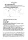
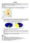
trees, describe, jungle, forest, light, these, other, rainforest, examples, species, tropical, soil, emergent, liana, nature, during, such, fall, drip, forests, structure, tall, grow, even, above, reach, eagle, ground, spend, possible, below, features, known, usual, tips, easily, shed, away, quick, crown, protect, another, size, plant, upon, sometimes1. What is a biome? A biome is a large area of distinctive plants and animals, which are adapted to that environment. The climate and geography determines which type of biome can exist there. 2. Using the map describe the distribution of the biome (tropical rainforest/tropical deciduous forest). Tropical rainforest South America, Africa (Madagaskar), Asia. Tropical deciduous forest South America, Asia, Australia 3. Compare the climates (tropical rainforest/tropical deciduous forest). Tropical rainforest is wetter than tropical deciduous forest. Both of these biomes have a warm climate all year long. Tropical deciduous forest has a well defined dry and a wet season. During the dry season, the trees in tropical deciduous forest lose their leaves. 4. Using the climate diagram describe the climate of the region (tropical
Different types of forests and their forms of usage TARTU 2010 Forest A forest (also called a wood, woodland, wold, weald, holt, frith) is an area with a high density of trees. Forests cover approximately 30% of land and 9.4% of all the planet earth. They are also responsible for regulating our planet's climate and act as large purifiers of airs, by absorbing carbon dioxide, and giving out oxygen. Different types of forests Forests are divided into following main types: o Tropical forest o Subtropical forest o Plantations o Boreal forest o Temperate forest o Seasonal or monsoon forest Tropical and Subtropical Forests
Also are finded in tempered areas of South America. Climate: The average temperature in temperate forests is 50° F. Summers are mild, and average about 70° F, while winter temperatures are often well blow freezing. The average yearly precipitation is 30-60 inches. This precipitation falls throughout the year, but in the winter it falls as snow. There are four seasons in this biome, with warm summers and cold winters, often snowy. In autumn, the leaves change color and fall from the trees. The leaves decay on the forest floor, so the soil is very rich. Because of this, and because of the long growing season, many deciduous forests have been cut down for farming purposes. Plants: Trees of this biome include hardwoods such as maple, oak, hickory, and beech. There are often some evergreens, such as hemlock, spruce, and fir growing amongst them. Decidous forests have usually 3-5 layers of plants; Top layer, or canopy: tall deciduous trees.
Savanna A savanna is a grassland ecosystem with scattered trees or shrubs. In savannas trees are small or widely spaced so that the canopy does not close. It is often believed that savannas are characterized by widely spaced, scattered trees, however in many savanna communities tree densities are higher and trees are more regularly spaced than in forest communities. The open canopy allows sufficient light to reach the ground to support an unbroken herbaceous layer consisting primarily of C4 grasses. Savannas are also characterised by seasonal water availability, with the majority of rainfall being confined to one season of the year. Savannas can be associated with several types of biomes. Savannas are frequently seen as a transitional zone, occurring between forest and desert or prairie. Although the term savanna is believed to have originally come from a Native American word
2. Where is prairie, pampas, steppe, and veldt situated? EurasiaSteppe, North America-Prairie, South AmericaPampa, South AfricaVeldt 3. Using the climate diagram describe the climate of the region. Temperate deciduous forest -Well-defined seasons with a distinct winter characterize this forest biome. Moderate climate and a growing season of 140-200 days during 4-6 frost-free months distinguish temperate forests. Temperature varies from -15° C to 25° C. Precipitation (750-1500 mm) is distributed evenly throughout the year. Temperate grassland- Semiarid, continental climates of the middle latitudes typically have between 25 cm and 50 cm of precipitation a year. Much of this falls as snow, serving as reservoir of moisture for the beginning of the growing season
The mainland and larger islands are mountainous and rugged, divided by large fertile upland valleys. Fast- flowing rivers from the highlands descend to the coastal plains. A line of active volcanoes stretches along the north coast of the mainland and continues on the island of New Britain. To the north and south of this central mountain range on the main island lie vast stretches of mangrove swamps and coastal river deltas. /1/ Volcanoes and thermal pools are also found in the southeast of other islands. Papua New Guinea offers the greatest variety of terrestrial ecosystems in the South Pacific, including five types of lowland rainforest, 13 types of montane rainforest, five varieties of palm and swamp forest and three different mangrove forests. Two-thirds of the world's species of orchids come from New Guinea. /1/ Birds include 38 species of the bird of paradise, and the megapode and cassowary. Marsupials and mammals include cuscus, tree kangaroos,
The two major nutrients are nitrogen and phosphorus. Nitrogen is created by biological fixation, and phosphorus is created by precipitation. The most distinctive characteristic of tundra soil is its permafrost, a permanently frozen layer of ground. The average winter temperature is -28°C, but the average summer temperature is 3-16°C. During the brief summers, the top section of the soil may thaw out allowing plants and microorganisms to grow and reproduce. However, these plants and microorganisms become dormant during the cold winter months. Soil is formed slowly. The constant freezing and thawing in the tundra helps to break the rocks into smaller pieces. Permafrost consists mostly of gravel and finer material. The arctic tundra is also a windy place and winds can blow between 48 to 97 kilometres. The tundra is basically like a desert when it comes to precipitation. Only about 150-250 millimetres of precipitation (mostly snow) fall each year. When water
1. Key features for all studied biomes. Tundra The main seasons are winter and summer. The tundra is the world's coldest and driest biomes. The average annual temperature is -28° C. Nights can last for weeks when the sun barely rises during some months in the winter, and the temperature can drop to -70° C. During the summer the sun shines almost 24 hours a day. Summer are usually warm. Average summer temperatures range from 3° to 16°C. TaigaTaiga is the Russian word for forest and is the largest biome in the world. It stretches over Eurasia and North America. The taiga is located near the top of the world, just below the tundra biome. The winters in the taiga are very cold with only snowfall. The summers are warm, rainy, and humid. Some of the animals in the taiga hibernate in the winter, some fly south if they can, while some just cooperate with the environment. GrasslandsGrassland biomes can be found in the middle latitudes
THE IMPORTANCE OF THE RAINFOREST The beauty, majesty, and timelessness of a primary rainforest are indescribable. It is impossible to capture on film, to describe in words, or to explain to those who have never had the awe-inspiring experience of standing in the heart of a primary rainforest. Rainforests have evolved over millions of years to turn into the incredibly complex environments they are today. Rainforests represent a store of living and breathing renewable natural resources that for eons, by virtue of their richness in both animal and plant species, have contributed a wealth of resources for the survival and well-being of humankind. These resources have included basic food supplies, clothing, shelter, fuel, spices, industrial raw
The average rainfall measures 8-13 cm in many areas. The maximum annual precipitation over a long period of years has been 37 cm with a minimum of 5 cm. In cold deserts the mean winter temperature is between -2 to 4° C and the mean summer temperature is between 21-26° C. The winters receive quite a bit of snow. The mean annual precipitation ranges from 15-26 cm. Vegetation Canopy in most deserts is very rare. Plants are mainly ground-hugging shrubs and short woody trees. Leaves are "replete" (fully supported with nutrients) with water- conserving characteristics. They tend to be small, thick and covered with a thick cuticle (outer layer). These plants include: yuccas, ocotillo, turpentine bush, prickly pears, false mesquite, sotol, ephedras, agaves and brittlebush. The spiny nature of many plants in semiarid deserts provides protection in a hazardous environment. Many plants have silvery or glossy leaves, allowing them to reflect more radiant energy
In 1851 gold was discovered in eastern Australia. This brought along the great gold rush. Thousands of people went to the new land to find fortune. Forty years later the gold was found in the west. The miners of the east had a very hard time, the water was scarce and the roads were bad. But then the railway was built. Many of people who came to Australia to find gold stayed on to do other kinds of work. The found that Australia has other riches too, such as coal, copper, ironore, nickel, natural gas and more. The forests had good timber. Along seashorepearls and tortoise shells could be gathered. Some needed to manufacture such things as butter, cheese, shoes and clothing. Geographical position Australia is located in southern hemisphere. It's the only continent except for Antarctica that is all south of equator. Sometimes Australia is called the Island Continent. There is a great reason why
Five stars represent the Constallation Southern Cross and a large star is for the country's states and territories. The coat of arms features a kangaroo and an emu. The kangaroo and emu are chosen for the coat of arms of Australia because they can only move forward just like Australia. The national anthem of Australia is "Advance Australia Fair". This replaced the "God Save the Queen" as Australia's national anthem in 1984. Aboriginal art uses Earth Colours(white, red, orange, brown). These are the colours of the desert. Aboriginal artists made their paints from natural materials. Aboriginal paintings also use lots of dots. They used their fingers or sticks. There weren't any art shops where they could buy brushes. Aboriginal art includes lots of symbols for the natural things around them. Australia got its independence in 1st Jan 1901. The Commonwealth of Australia is a constitutional monarchy, in practise a parliamentary democracy
1. Where is temperate grassland situates? Temperate grasslands are located in the mid-latitudes. There are six large areas of temperate grassland: the Pampas in South America, the Veld in Africa, the Canterbury Plains in New Zealand, the Murray-Darling Basin in Australia, the Prairies in North America and the Steppes in Central Asia. 2. Colour the distribution of temperate grassland on the map. 3. How is temperate grassland called in these regions? Eurasia - steppe Hungary - puzda North America - prarie South America - pampa South Africa - veldt 4. What is forest steppe (forest steppe – metsastepp)? A forest steppe is a temperate-climate ecotone and habitat type composed of grassland interspersed with areas of woodland or forest. 5. Describe the climate of temperate grassland. Temperate grasslands have a temperate continental climate, which is cooler than savannas.
It’s the official name of the country. Australia is the smallest continent, but one of the largest countries on Earth. It’s 6th largest country. Its area is about 7.6 million sq km. One third of it is occupied by deserts. It’s both the flattest and, except for Antarctica the driest. Neighbouring countries include Indonesia, East Timor and Papua New Guinea in the north, the Solomon Islands, Vanuatu in the northeast, and New Zealand in the southeast. Its capital is Canberra. Other big cities are Melbourne, Sydney, and Brisbane. National language in Australia is English. Monetary unit is Australian dollar. Their national holiday is on the 26th of January. In 1788 on the 26th of January the first fleet arrived at Botany Bay and established a penal colony near modern-day Sydney. Geographical Position Australia is located in the Southern Hemisphere. It’s the only continent except for Antarctica that is all south of equator
The unofficial anthem of Australia is `Waltzing Matilda'. It tells a story about a swagman, who has named his sleeping blanket Matilda. He is chased by police for stealing a sheep which he wanted to eat. The swagman doesn't want to be punished, so he jumps into a billabong and drowns. The golden wattle was proclaimed the official national floral emblem in 1988. It is a spreading shrub or a small tree, which grows in the under storey of open forest, woodland and open scrub in South Australia, Victoria, New South Wales and the Australian Capital Territory. Green and gold were proclaimed Australia's national colour by the Governor-General in 1984. Before the proclamation, Australia had no official colour, although three colour combinations traditionally had a claim to be Australia's national colours: red, white and blue; blue and gold; and green and gold. Head of State:
of waste disposal. Developed countries are notorious for producing an excessive amount of waste or garbage and dumping their waste in the oceans and, less developed countries. Nuclear waste disposal has tremendous health hazards associated with it. Plastic, fast food, packaging and cheap electronic wastes threaten the well being of humans. FIND OUT 5 WAYS HOW TO MANAGE WASTE. 5. Loss of Biodiversity: Human activity is leading to the extinction of species and habitats and loss of bio- diversity. Eco systems, which took millions of years to perfect, are in danger when any species population is decimating. Another example is the destruction of coral reefs in the various oceans, which support the rich marine life. FIND OUT 5 WAYS HOW TO HALT THE LOSS OF BIODIVERSITY 6. Deforestation: Our forests produce fresh oxygen and help in regulating temperature and rainfall. At
He walked to school, read books instead of watching TV, played the trumpet instead of Guitar Hero, and turned off the lights anytime he left a room. Then one evening, there was a power outage. The lights went out, the TV turned off, and everything became very quiet. Jules became very upset, and quite scared. She couldn't do anything that she wanted to do. She didn't think she could survive. Meanwhile, Les didn't seem to mind at all. He was able to light a few candles and he could still read his books, practice his trumpet, and hang out and play cards with his family. The two friends then realized that there was a big difference in their lifestyles and the amount of energy they used. So Jules decided she should figure out how much energy Les used and then compare her energy consumption to how much she really needed. To do this, they figured out how much energy Jules was using for entertainment, light, heating and
Distilled water(doesn't contain CO 2), has pH level 7. Liquids with pH level less than 7 are acidic, liquids with pH level greater than 7 are alkaline. Unpolluted rain has a pH level over 5.7, so it is slightly acidic. Affected areas Places significantly impacted by acid rain around the globe include most of eastern Europe from Poland northward into Scandinavia, the eastern third of the United States and southeastern Canada. Other affected areas include the southeastern coast of China and Taiwan Causes · It is caused when sulfur dioxide and nitrogen oxides are released into the air. In the atmosphere they react with water, oxygen and other chemicals to form more acidic pollutants, known as acid rain. Sulfur dioxide and nitrogen oxides dissolve very easily in water and can be carried very far by wind
Miina Härma Gymnasium Acid Rain Report Compiler: Teisi Timma 8a Teacher: Esther Linask Tartu 2009 Acid Rain Acid rain is rain consisting of water droplets that are unusually acidic because of atmospheric pollution - most notably the excessive amounts of sulfur and nitrogen released by cars and industrial processes. Acid rain is also called acid deposition because this term includes other forms of acidic precipitation such as snow. Acidic deposition occurs in two ways: wet and dry. Wet deposition is any form of precipitation that removes acids from the atmosphere and deposits them on the Earth's surface. Dry deposition polluting particles and gases stick to the ground via dust and smoke in the absence of precipitation. This form of deposition is dangerous however because precipitation can eventually wash pollutants into streams, lakes, and rivers.
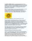
andma) to all plants of the genus(perekond, sugu) Helianthus, many of which are perennial(alaline, aastaringne) plants. What is usually called the flower is actually a head (formally(ametlikult) composite(liit-, komposiit- ; korvõieline, komposiit) flower) of numerous flowers (florets) crowded(täistuubitud, tunglev, rahvarohke) together. The outer flowers are the ray florets(pähik (õisiku osa) and can be yellow, maroon, orange, or other colors, and are sterile(steriilne, viljatu). The florets inside the circular head are called disc florets. Sunflower head displaying florets in spirals of 34 and 55 around the outside The florets within this cluster(kobar, kimp, klaster, parv ; kobarasse kogunema) are arranged (korraldatud, ettekavatsetud)spirally(spiraalselt). Typically each floret is oriented(suunitlusega) toward(poole) the next by approximately(umbkaudu, ligikaudu)
6 million square kilometres big. It is often called the island continent because it is rather small for a continent and very big for an island. There are only five countries bigger than Australia in the World. There are five states in the mainland. Tasmania is also considered as a state so there are six states. The Northern Territory and Canberra are also independent but they are not states. Canberra is the capital of Australia and it is situated between Sydney and Melbourne because both of these cities wanted to be the capital. The population is about 19 million people and growing. New South Wales is the most populated state and Victoria is the most densely populated state. The national language is English. It is English because British settlers came to live in Australia in the past and they brought convicts with them who were also British. Symbols. The Australian Flag came into being after the federation of the
Natural Zones and Flora. There are five distinguishable natural zones in Australia. In the very east there are wet forests (1.) that occupy the space between the Great Dividing Range and the eastern coast. Westward from the Great Dividing Range the wet forests give place to beautiful grasslands with some trees . These grasslands are called the savannas (2.). Farther west the trees disappear and the bushlands (3.) begin. The real desert (4.) occupies the centre of the Western Plateau. In the very southwest there are thin forests of evergreen trees (5.). Most of Australian trees are kinds of eucalyptus trees (or gum trees to Australians) and acacia ( wattle to Australians). Eucalyptus trees are found everywhere in Australia. There are many kinds of them and they greatly differ in size. One kind, the
Pomponius Mela, the Roman geographer, recorded in his De Chorographia, written circa AD 43, that there were thirty Orkney islands and seven Haemodae (possibly Shetland). There is certainly evidence of an Orcadian connection with Rome prior to 60 AD from pottery found at the broch of Gurness. By the time of Pliny the Elder, who died in AD 79, Roman knowledge of the geography of Scotland had extended to the Hebudes (The Hebrides), Dumna (probably the Outer Hebrides), the Caledonian Forest and the Caledonii. Ptolemy, possibly drawing on earlier sources of information as well as more contemporary accounts from the Agricolan invasion, identified 18 tribes in Scotland in his Geography, but many of the names are obscure and the geography becomes less reliable in the north and west, suggesting early Roman knowledge of these area was confined to observations from the sea. Geography of Scotland !
The Bella Coola Development Study merges community requirements for the envisioned facility and the alternative approaches to building on the Bella Coola Northern Pointe site. Consultants’ reports regarding structural considerations and tree evaluation are included for their continued application to the problem. An effort has been made to work with the full extent of space requirements currently voiced by the Western Division Management Center and the Bella Coola Village Organization. Other organizations were queried to form the basis of judgment in determining the overall need. This recognizes that as the program development progresses, tenant requirements may change, but the essential square footage and cubic limitations for a below grade structure will remain. In addition, it has been envisioned that jointly required facilities would be available for all organizations to use on a shared basis, utilizing movable walls for privacy.
1. Bacteria a) Heterotrophic bacteria, eg. symbiotic and non - symbiotic N2 fixers, ammonifier, cellulose decomposers, denitrifiers b) Autrotrophic bacteria, eg. nitrosomonas, nitrobacter, sulphur oxidizers, etc; 2. Fungus; 3. Viruses 4. Actinomycetes and stretomyces; 5. Algae eg. BGA, yellow gree algae, golden brown algae. The soil microflora largely depends on the type of soil, temperature, moisture, plant growth, nutrients, pH, and many other factors which may vary between locations but also within a single plot and over very small distances (OECD, 2007). Nevertheless of the quantity of microflora, biomass of all microorganisms living in soil play an important role in the functioning of entire soil ecosystems because their enormous biochemical activity (Barabasz et al. 2002). Soil microflora cycles carbon, nitrogen, phosphorus, and sulfur, plays a role in soil structure
More than 6,000 miles of ocean separate in from the America. Australia is the only continent except for Antarctica that lies all south of the equator. The natural zones of Australia are very various. There are deserts, semi deserts, grasslands, savannas, bushlands and rainforests. The wet forests occupy the narrow region in the east. Most of the animals, birds and insects live in that region, because there is enough food. The savannas which are grasslands with some trees are mostly in the west. Farther west are the bushlands. The real deserts occupy the centre of the Western Plateau. In the very south west there are thin forests of evergreens trees. Australia is the driest inhabited continent, the flattest, and has the oldest and least fertile soils. Only the south-east and south-west corners of the continent have a temperate climate. The northern part of the country, with a tropical climate, has vegetation consisting of rainforest,
Tallinna Inglise Kolledz Canada. The land of diversity. Tallinn 2006 Canada. If you had to use two words to describe Canada, they might be large and diverse. Canada is the second largest country in the world with a territory of about 10 million square kilometers and it is bordered by three oceans: the Arctic, the Pacific and the Atlantic Oceans. The population of Canada is about 31 million people. About 77% of the people live in cities which lie in a band about 100 miles wide above the border of the United States. The capital of Canada is Ottawa. Other large cities are Montreal, Toronto,
But everyone can find the activity he likes most. Climate in Great Britain The British Isles which are surrounded by the ocean have an insular climate. There are 3 things that chiefly determine the climate of the United Kingdom: the position of the islands in the temperate belt; the fact that the prevailing winds blow from the west and south-west and the warm current -- the Gulf Stream that flows from the Gulf of Mexico along the western shores of England. All these features make the climate more moderate, without striking difference between seasons. It is not very cold in winter and never very hot in summer. So, the British ports are ice-free and its rivers are not frozen throughout the year. The weather on the British Isles has a bad reputation. It is very changeable and fickle. The British say that there is a climate in other countries, but we have just weather. If you don't like the weather in England, just wait a few minutes.
r w gametes C , C ; F1 genotypes and phenotypes 1 mark: r w F1 genotypes (all) C C F1 phenotypes (all) pink; F2 genotypes and phenotypes 1 mark: r w r w gametes C , C C , C ; r r r w r w w w F2 genotypes C C C C C C C C F2 phenotypes red pink (pink) white; F2 ratio 1:2:1; accept other symbols if key given. accept r and w as symbols without key. 6 (c) (i) 65; 130; 65; 3 (ii) 0.138 + 0.007 + 0.061; (or other suitable working) 0.206 – 0.208; 2 marks for correct value if no working shown ecf for both marks but calculated value must be to three decimal
metres. The bark is thin, brown, coming off in small flakes aligned with the stem. The leaves are lanceolate, flat, dark green and highly poisonous. The seed cones are highly modified, each cone containing a single seed long partly surrounded by a modified scale which develops into a soft, bright red berry-like structure called an aril. The arils are mature 69 months after pollination, and with the seed contained are eaten by thrushes, waxwings and other birds. The aril is not poisonous. The seeds themselves are extremely poisonous and bitter, but are opened and eaten by some bird species Toxicity The bark, stem, needles and seeds of the yew are poisonous, although birds can eat the berries without digesting the seed. This dangerous side of the yew has led some to call it the "tree of death,,. Symptoms include staggering gait, muscle tremors, collapse, difficulty breathing,
Autor: Klass : 9 Juhendaja: Võnnu 2013 Estonia officially the Republic of Estonia, is a state in the Baltic region of Northern Europe It is bordered to the north by the Gulf of Finland, to the west by the Baltic Sea, to the south by Latvia and to the east by Lake Peipus and Russia.Across the Baltic Sealies Sweden in the west and Finland in the north. The territory of Estonia covers 45,227km2 The Estonian climate resembles that of other countries on the Baltic littoral. On account of the country's proximity to the sea, the skies are often cloudy, and rain often falls in the spring and autumn, in the winter the rain turns to snow. The highest point in Estonia is Suur Munamäg It is in fact the highest point in the Baltic region Forest cover over one half of Estonia. The most common types of tree are pine, spruce and birch. Estonia, along with Finland and Sweden are the countries with the greatest percentage of forested land
Psychology Gleitman Blood flow in the brain during different activities: the rate of blood flow is measured by special radiation counters that are placed at various points of the skull and that monitor radiation from mildly radioactive gas injected into the bloodstream. Blood flow pattern depends on what the patient does ( different pattern is found when person is reading aloud, yet another when he watches a moving light and so on). Ambiguous sights and sounds: The way ambiguous figures are perceived often depends on what we have seen just before. For example, if we are first shown an unambiguous figure of a rat, the ambiguous picture will be seen as a rat. If we are first exposed to an unambiguous face, we see the ambiguous figure as a face. What holds for visual patterns also holds for language. Many utterances are ambiguous. If presented out of context, they can be undestrood in several different ways.
It is three kilometers long and 348 metres high. There is another 2000 meters under the ground. Uluru is 600 000 000 years old and it is the largest rock in the world. The Great Barrier Reef. One of the natural wonders of the modern world is the Great Barrier Reef. It is located off the northeast coast of Australia. It is the biggest coral reef in the world extending 2000 kilometers along the coast of Queensland. It consists of more than 600 coral islands. Some of them are true coral islands, other are the tops of submerged mountain ranges covered with lush tropical growth. Most of the islands are inhabited and many of them have been developed as tourist resorts. Scientists estimate that the reef is more than thirty million years old. It had its beginning as a tiny animal known as the polyp. It protects itself by forming an external skeleton of lime. When it dies its shell hardens. It has been growing for thirty million years. There are more