Italy Sicily Capital: Rome Size: 301,230 sq km Population: 57,6 million San Marino The Vatican City Highest point: Mont Blanc (4,807 m) The Alps in the north and the Apennines in the center of Italy The north of Italy: cold, harsh winters but hot and humid summers Central Italy: smaller temp. difference between summer and winter The south of Italy: warm and hot summers, mild winters Click to edit Master text styles Second level Sicily- Tonnara di Scopello Third level Gargano Fourth level
Mexico.Each day before sunrise some 11,600 boats pull out to harvest shrimp,clams, oysters, crabs, and fish- enough to supply 12 percent of the country's commercial seafood needs. The grit and grime of the oil industry and the frantic sorting of fish this is what many outsiders think of as the essence of Veracruc Yet there is an other a calmer, quieter Vera cruz down any country road.In the fishing village of Mandinga, for example a cool Gulf breeze softens the humid afternoon heat as the town's residents mestizos partly descenced from African slaves go about their business along dusty streets that Alfonso."so they come back.At least here they alwayshave a job" And hey have their music.Of all Veracruz's cosmpolitian influences food laced with Italian spices, heading practices from Arfica, sensual dances from Cuba it is music that speaks to the souls of the state 6.7 millon people.Beneah sun-drenched palm trees,tris of string
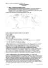
President of Russia is Vladimir Putin. National anthem of Russia: Gosudarstvenny Gimn Rossiyskoy Federatsii https://www.youtube.com/watch?v=AOAtz8xWM0w Vladimir Putin Kreml Mount Elbrus Topography and climate Mount Elbrus is the highest point in Caucasus, Russia and Europe (5 642 m). Russia has thousands of rivers. Longest river in Russia is Volga. Lake Baikal is the largest fresh water lake in Russia. Humid continental climate is the dominant in Russia. Record low temperature is -71,2. Record high temperature is 43,2. Interesting facts Russian Federation spans trough 9 time zones, (UTC+3 to +12a). Largest city`s are Moscow, Saint Peterburg and Novosibirsk. The 2014 Winter Olympics were held in Sochi in the south of Russia. In 1957 the first Earth-orbiting artificial satellite, Sputnik 1. CELEBRITIES Leo Tolstoy
Estonia is a state in the Baltic region of Northern Europe. It is bordered to the north by the Gulf of Finland, to the west by the Baltic Sea, to the south by Latvia (343 km), and to the east by Lake Peipus and Russia (338.6 km). Across the Baltic Sea lies Sweden in the west and Finland in the north. The territory of Estonia covers 45,227 km2 (17,462 sq mi), and is influenced by a humid continental climate. The Estonians are a Finnic people, and the official language, Estonian, is a Finno-Ugric language closely related to Finnish, and distantly to Hungarian and to the Sami languages. Estonia is a democratic parliamentary republic divided into fifteen counties, with its capital and largest city being Tallinn. Estonia's population of 1.3 million makes it one of the least-populous member states of the European Union, Eurozone and the North Atlantic Treaty Organization. A
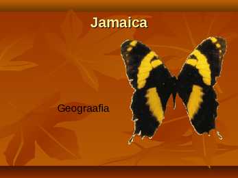
Jamaica Location and geography Capital-Kingston Cities-Spanish Town, Mandeville, Port Antonio, Negri Neighbours-Haiti, Cuba, South America, Mexico General facts Population- 2, 790 427 Major languages- English, (Jamaica english) Money-Jamaican dollar 1 dollar coin National symbols Flag-The Cross, Black, green, and gold Flower-Lignum vitae National Motto: "Out of Many, One People"(üks ühe,kõik kõigi eest) National Bird: Red-billed Streamertail Goverment Queen-Elizabeth II Monarchy-Constitutional Governor-General-Patrick Allen Prime Minister-Portia Lucretia Simpson-Miller Important sights/places to visit The Doctor's Cave Beach The Rose Hall Great House Dunn's River Falls Famous peple Usain Bolt -- Olympian Bob Marley-- Singer Grace Jones -- Singer Interesting facts a...
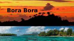
going mainly to Japan, as well as mother-of-pearl and pearl production. Agricultural practices produce sugar, vanilla, rum, and copra (used to extract coconut oil). Despite all of these activities, tourism is by far the leading economic contributor. The island has several hotels to cater to tourists, including twelve 4 and 5-store places like Club Med, for example. 3 Bora Bora experiences a tropical, humid climate with relatively stable temperatures year- round. The island is characterized by its volcanic rock mountains and raised coral beds found at high elevations. Coconut palms, pandanus trees, and breadfruit trees cover the landscape. Like most islands, animal life is not found in abundance although, wild pigs, rats, and lizards can be seen from time to time. The ocean waters surrounding the island. The coral reef provides shelter to a large number of fish, sponge, and giant manta ray species
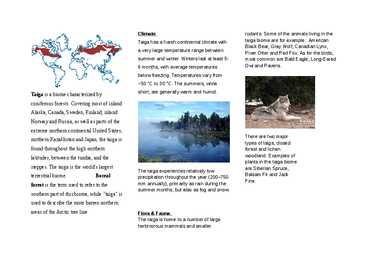
summer and winter. Winters last at least 5- most common are Bald Eagle, Long-Eared 6 months, with average temperatures Owl and Ravens. below freezing. Temperatures vary from -50 °C to 30 °C. The summers, while short, are generally warm and humid. Taiga is a biome characterized by coniferous forests. Covering most of inland Alaska, Canada, Sweden, Finland, inland Norway and Russia, as well as parts of the extreme northern continental United States, There are two major northern Kazakhstan and Japan, the taiga is types of taiga, closed
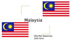
Malaysia Ülle-Mai Kesamaa 10th form Content Location/Geography Geography British related history People Location/Geography ★ Continent - Asia ★ Region - Southeast Asia. ★ Located on the Sunda shelf ★ 2 distinct parts to this country: Peninsular Malaysia and East Malaysia ★ Total land area is about 329 847 km2 , ranked 67th ★ Capital is Kuala Lumpur Geography ★ Tropical climate, hot and humid throughout the year ★ Highest mountain range is the Crocker Range. ★ Tallest mountain is Mount Kinabalu, Kinabalu National Park, UNESCO British related history ★ English traders in Malay waters since 17th century ★ European power dominant with the arrival of the british ★ The britains interests in Malaysia were predominantly economic, not because of the territorial control. Just another base of trade People ★ Population 28 million people
Flushing, Hempstead, Jamaica, Newtown, and Oyster Bay. • The New York City Borough of Queens was authorized on May 4, 1897. Geography • Queens is located on the far western portion of Long Island and includes a few smaller islands. • Queens County has a total area of 460 km2, of which 280 km2 is land and 180 km2 is water. • Brooklyn, the only other New York City borough on Long Island, lies just south and west of Queens. • Summers are hot, humid, and wet. Autumn is similar to spring, while snowfall generally begins in December. Culture • There are 138 languages spoken in the borough. • As of 2010, 43% of Queens residents age 5 and older spoke English at home as a primary language. • while the other people spoke Spanish, Chinese, various Indian languages, Korean, Russian, Italian, Greek, French, Polish, Hindi, Urdu, other Asian languages, French, Arabic and Hebrew was spoken as
Estonia Estonia is a country in Eastern Europe. It's a small country beside the Baltic Ssea. Our neighbours are Finland, Russia, Latvia and Sweden. Estonia's surface area is 45,227 square kilometres wide. The population of Estonia is around 1,34 million people. We have four seasons in Estonia. The air is very humid and it rains quite often, especially in spring and autumn. We usually have long winters and plenty of snow, but sometimes we haven't even had snow. Summers are is mostly warm and beautiful in Estonia. Estonia is well known for it's amazing countryside. We don't have any big mountains, but we do have over a thousand islands and over a thousand lakes that are worth seeing. One fifth of Estonia is covered by wetlands and almost one forth of the territory is forested
New York is the most populous city in the United States. New York exerts a powerful influence over global commerce, finance, media, culture, art, fashion, research, education, and entertainment. Introduction The city's 2009 estimated population approached 8.4 million Land area of 305 square miles (790 km) Currency- US dollar Language English Website www.nyc.gov Climate New York City has a humid subtropical climate The average temperature in January, the area's coldest month, is 32.1 °F (0.1 °C). However temperatures in winter could for a few days be as low as 10 °F (-12 °C) and as high as 50 °F (10 °C). November, December Weather: Expect highs in the 40-50 range in November and 30-40 range in December. It can be freakishly warmer or colder here and there, but it's not likely. What to Wear: Bring a heavier jacket and leave
Estonians have two personalities-a summer one and a winter one Estonia is a country in Eastern Europe. It's a small country beside the Baltic Sea. Our neighbours are Finland, Russia, Latvia and Sweden. Estonia's surface area is 45,227 square kilometres. The population of Estonia is around 1,3 million. We have four seasons in Estonia. The air is very humid and it rains quite often, especially in spring and autumn. We usually have long winters and plenty of snow, but sometimes we haven't even had snow. Summers are mostly warm and beautiful in Estonia. In winter our nation is mostly very passive, becouse it is quite cold in outside, we are like bears who sleep in winter, but we still go to school and work even if we are like so tired and don't wanna go out. Our winter is like too long and people are starting to miss summer,sun, beach and ice
27. Ookeanihoovused- ocean currents 28. Õhurõhk- air preassure 29. Sademed- precipitation 30. Vesi aurustub ja muutub veeauruks- water vapowizes and turnis into vapour 31. Küllastunud veeaur- saturated vapour 32. Udune ja pilvine ilm- foggy and cloudy weather 33. Libe ja tuuline ilm- slippery and windy weather 34. Pikselöök ja kõuemürin- lightning and thunder 35. Linn on täis sudu ja õhk on väga niiske- city is full of smog and air is very humid 36. Tuul puhub Vaikselt Ookeanilt- wind blows from Pacific ocean
The most important ranges are the Sierra Nevada and the Cascades. The U.S has several long rivers, mostly located in the eastern part of the country. The longest is the Missouri (~4,000 km), a tributary of the Mississippi. The tributaries of Mississippi-the Ohio and the Tennessee are also very long. Climate Every type of climate can be found in the United States due to the tremendous size of the North American landmass. Most of the country has a humid continental climate with hot summers and cold winters. Because of the lack of the natural barriers in south and north, dry air flows south from Canada, and warm, humid air north from the Gulf of Mexico. The Great Plains and Midwest have spectacular weather, with hot and humid summers. The rainfall decreases to the west due to rain shadow caused by Sierra Nevada. The southwest part of the Great Plains is the hottest and driest region of the U.S
9. earthquake (n) series of vibrations induced in the earth's crust 10. drought (n) a period of dry weather 11. wilderness (n) an area uninhabited by people 12. scenery (n) the general appearance of a place/landscape 13. peak (n) the pointed top of a mountain 14. summit (n) highest point of a mountain 15. existence (n) presence, being, state of existing 16. implication (n) assumption 17. drizzle (n) light rain 18. humid (adj) damp, moist 19. scattered showers (n) spread/distributed rain 20. heavy rain - 21. severe storm violent storm 22. frost (n) hoarfrost, frozen dew 23. cod (n) type of fish tursk 24. trout (n) type of fish forell 25. in order to so as to 26. so as to in order to 27. in case - 28. to erupt to burst, eject, break out 29. debris the remains of anything broken 30. to flee to run away from danger 31
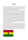
the lucrative slave trade in the 17th century. The area later became known for growing cacao, the source of cocoa beans. Introduced there in the late 19th century, cacao continues to provide an important export for Ghana. Ghana's climate, like that of the rest of the Guinea Coast, is determined largely by the interplay of two air masses: a hot, dry continental air mass that forms over the Sahara and a warm, humid maritime tropical air mass that forms over the South Atlantic. Both air masses move toward the Equator with their hemispheric winds and meet at the Guinea Coast for several months each year. Continental air moves southward with the northeast trade winds, known in western Africa as the harmattan, and maritime tropical air moves northward with the southwest trades.
greasy burgers, and soft drinks. Why is it so important to drink plenty of liquids during exercise? Water acts as your body's cooling system. You don't want to get dehydrated. The best way to stay hydrated is to drink plenty of fluids with meals, and drink about 2 cups (16 ounces) of water 2 hours before exercise. Is it better to stay hydrated with sports drinks or plain water? Water is often enough. But if you're exercising for more than 60 minutes in hot, humid conditions, sports drinks may help. They give you carbs and sodium, as well as fluids. Sports drinks are also a good choice if you play team sports like soccer or football, especially when the temperature and humidity are high. If you sweat a lot, a sports drink might be preferable to water. Is it bad to exercise on an empty stomach, especially in the morning? It depends on the type of exercise. A brisk walk or light jog on an empty
Estonia officially the Republic of Estonia, is a country in the Baltic region of Northern Europe. It is bordered to the north by the Gulf of Finland, to the west by the Baltic Sea, to the south by Latvia and to the east by Russia. Across the Baltic Sea lies Sweden in the west and Finland in the north. The territory of Estonia covers 45,227 km2, and is influenced by a humid continental climate. Estonia is a democratic parliamentary republic divided into fifteen counties, with its capital and largest city beingTallinn. With a population of 1.3 million, it is one of the least-populous member states of the European Union. The Estonians are a Finnic people, and the official language, Estonian, is a Finno-Ugric language closely related to Finnish The history of Estonia is a part of the history of Europe. Estonia was settled near the end of the last glacial era,
• Mount Otemanu, the highest point at 727 metres • Was colonized by Polynesians, New Zealander and explorers such as James Cook in 1777 • Interestingly, there is no "B," in the local Tahitian language, so its actual name is Pora Pora, meaning "first born" Vaitape The largest city Population 4 927 Some supermarkets Many fruits are imported from Faaa Weather And Biodiversity Tropical, humid climate with relatively stable temperatures yearround Characterized by it’s volcanic rock mountains and raised coral beds found at high elevations Coconut palms, pandanus trees, and breadfruit trees cover the landscape. Animal life is not found in abundance although, wild pigs, rats, and lizards can be seen from time to time. The ocean waters surrounding the island. The coral reef provides shelter to a
Thailand's main religion is Buddhism which 95% of the population believes in. Thailand has no deadly spiders and only 2 snakes with deadly venom: the Malayan Krait and the King Cobra. Most snakes will go away as fast as possible after seeing a human, even if confronted. Only a very big Python will think of a human as prey and even if it does start chasing you its very easy to outrun any snake on the planet. Thailand is a very warm place, but doesn't get too warm because of how humid the air is. Thailand has amazing places such as the big Buddha mountain and the Wat Rong Khun. What I don't like about Thailand is the traffic, Thailand has very bad drivers and it's hard to go for a walk as there's no places for pedestrians to walk. To cross the road, you have to look left and right for any cars and then run as fast as you can to the other side of the road. In Thailand it gets dark very early- about 18:30 pm. Then it's like night in Estonia
New Year's Day in Jamaica is a grand celebration time with festive parties and colorful fireworks shows. Famous "Johnkankus" parades and masquerades mark is an age-old New Year tradition of Jamaica. Interests Jamaicans, in general, have a large interest in sports. Cricket, Football (soccer), athletics and horse-racing are several popular sports. The climate The climate in Jamaica is tropical, with hot and humid weather. Jamaica lies in the hurricane belt of the Atlantic Ocean: as a result, the island sometimes experiences significant storm damage. The biggest river in Jamaica - Black River, Rio Cobre, Milk River, Rio Grande ja Martha Brae Church Port Antonios Fishing boats and bauxite cargo ships share the waterways near Alligator Pond. Jamaica-Beach Coffeeberries Enjoy these photos from beautiful Jamaica
the accumulation of humus. 6. How do the soils in tropical deciduous forest differ from the soils in tropical rainforest? The soil in tdf has more nutrients, because the leaves fall down and trees grow more sparsely. 7. Describe the layers of tropical rainforest. Emergents forest giants, the trees there are 50m or more. Canopy a dence layer, the trees there are 20-30m. There can be found many hardwoods, such as mahagony. Understory a dark and a humid area, contains saplings between the trunks of larger trees. 8. How does the vegetation in tropical deciduous forest differ from the vegetation in tropical rainforest? Trf has more kinds of trees than tdc. About 70% of the plants in trf are trees. 9. Using the picture (given in the test) describe how a plant is adapted to the life in tropical rainforest? Epiphytes, liana, climbers or stranglers. 10. What is an epiphyte
and the Lowlands. Tennessee covers 42,146 square miles, making it the 36th largest of the 50 states. 41,220 square miles of Tennessee are land areas. 926 square miles of Tennessee are covered by water. The highest point in Tennessee is Clingman's Dome at 6,643 feet above sea level. The lowest point in Tennessee is 178 feet at the Mississippi River. Major Rivers are Tennessee River, Mississippi River and major Lakes are Kentucky Lake, Norris Lake. Facts Most of the state has a humid subtropical climate. Generally, the state has hot summers and mild to cool winters. Tornadoes are possible throughout the state and those can be severe. The highest temperature recorded in Tennessee is 113°, Fahrenheit. This record high was recorded on July 29 and August 9, 1930 at Perryville. Lowest Temperature The lowest temperature in Tennessee, -32°, was recorded on December 30, 1917 at Mountain City. Tennessee is known as the "Volunteer State" (a nickname earned during the War of 1812
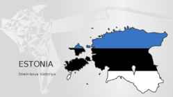
ESTONIA Strelnikova Viktoriya ESTONIA AT A GLANCE • Area: 45 227 square km • Climate: humid-temperate • Number of islands: 1 521. Largest islands are Saaremaa, Hiiumaa and Muhu. • Estonia is a green land, forests cover 55% of the country. • Estonia is a country of thousand of lakes, largest of these are Lake Peipsi and Lake Võrtsjärv. • Highest point: Suur Munamägi (Great Egg Hill), 318 m • The capital of Estonia is Tallinn (439 517 inhabitants (01.01.2016) or approx. 32% of the total population).
During the summer the sun shines almost 24 hours a day. Summer are usually warm. Average summer temperatures range from 3° to 16°C. TaigaTaiga is the Russian word for forest and is the largest biome in the world. It stretches over Eurasia and North America. The taiga is located near the top of the world, just below the tundra biome. The winters in the taiga are very cold with only snowfall. The summers are warm, rainy, and humid. Some of the animals in the taiga hibernate in the winter, some fly south if they can, while some just cooperate with the environment. GrasslandsGrassland biomes can be found in the middle latitudes. They can have either moist continental climates or dry subtropical climates. There are two different types of grasslands; tall-grass, which are humid and very wet, and short-grass, which are dry, with hotter summers and colder winters than the tall-grass prairie
Auckland War Memorial Museum It's a large multi-exhibition museum in the Auckland Domain, known for its impressive neo-classicist style. Eden Park It's the city's primary stadium and a frequent home for All Blacks rugby union and Black Caps cricket matches. It will be the location of the 2011 Rugby World Cup final. 8. What is its nickname? City of Sails, for its enthusiasm for the sport of sailing. 9. Describe the climate of Auckland. Auckland has a warm-temperate climate, with warm, humid summers and mild, damp winters. The average daily maximum temperature is 23.7 °C in February, and 14.5 °C in July. It is one of the sunniest spots in the country. It also has a high rainfall, which ensures the lushness of its rainforests. Summer is from December to February, Autumn or Fall is from March to May, Winter is from June to August, and Spring is from September to November. 10.Why is it easy to travel in A?
country in South America. Guyana is an Amerindian word meaning "Land of many waters" beacause of its rain forests dissected by numerous rivers, creeks and waterfalls, including the famous Kaieteur Falls. The country enjoys a diverse, multicultural society, high floral and faunal biodiversity, prize-winning rum, and Demerara sugar. Guyana is a major breeding area for sea turtles and other wildlife. The local climate is tropical and generally hot and humid. The major religions in Guyana are Christianity, Hinduism, Islam and other minor different faiths. Most Guyanese Christians are Protestants and include a mix of all races. Hinduism is dominated by the Indians who came to the country in the early 1800s, while Islam varies between Afro-Guyanese and Indian-Guyanese. When the first Europeans arrived in the area around 1500, Guyana was inhabited by the Arawak and Carib tribes of American Indians. Although Guyana was first sighted by Christopher
life. The South includes eleven states. The Midwest is a large, economically important region. It contains major industrial cities and much farmland. Geographically, the Midwest can be subdivided into three smaller regions: the Great Lakes area with many lakes, hills and forests; the prairie area south of it, which is flat and has good soil for farming; the Great Plains area to the west, much drier than the prairie. The Southwest is characterized by geographical variety: from humid lands in eastern Texas to drier prairies in Oklahoma and western Texas to mountains and deserts in Arizona and New Mexico. The Southwest area is rich in minerals. Cattle-breeding is also an important part of the Southwest's economy. The Rocky Mountain region includes the earth's youngest mountains. They have steep slopes and many peaks and picturesque valleys. The region isn't very populated. Most of the population is engaged in mining, cattle-breeding and farming.
Estonia Estonia, officially the Republic of Estonia, is a state in the Baltic region of Northern Europe. It is bordered to the north by the Gulf of Finland, to the west by the Baltic Sea, to the south by Latvia, and to the east by Lake Peipus and Russia. Across the Baltic Sea lies Sweden in the west and Finland in the north. The territory of Estonia covers 45,227 km 2, and is influenced by a humid continental climate. The Estonians are a Finnic people, and the official language, Estonian, is a Finno-Ugric language closely related to Finnish, and distantly to Hungarian and to the Sami languages. The population of Estonia is 1.5 million. Of this number 62 per cent are Estonians. The geography of the land is surprisingly varied. Islands make up 9,2 per cent of Estonian’s total territory, the largest islands are Saaremaa, Hiiumaa and Vormsi. The highest point is Suur Munamägi,
Eurasia - steppe Hungary - puzda North America - prarie South America - pampa South Africa - veldt 4. What is forest steppe (forest steppe – metsastepp)? A forest steppe is a temperate-climate ecotone and habitat type composed of grassland interspersed with areas of woodland or forest. 5. Describe the climate of temperate grassland. Temperate grasslands have a temperate continental climate, which is cooler than savannas. Temperate grasslands have warm, humid summers with an average temperature of 18° C and cool, dry winters with an average temperature of 10° C. Most of the rain falls as convection rain in the summer and sometimes frost and snow may occur in the winter. 6. What is the role of wildfires in the temperate grassland plants’ lifecycle? Wildfires play a very important role. They allow the grasslands to be open and free of trees and shrubs. Any seedling of a tree that appears is killed off by the intense heat. If the fire
Mining (iron and steel) and agriculture (fruit, grape and vegetables) are important there. Hunting, skiing, snowmobiling, wildlife and casinos are important part of tourism. The Atlantic Provinces consist of four provinces: New Brunswick (capital Fredericton), Nova Scotia (capital Halifax), Prince Edward Island (capital Charlotte) and Newfoundland & Labrador (capital St. John's). It's situated in the east of Canada. Population of the whole region is 2,3 million people. The climate is mild, humid and windy. The main industries are fishing, mining and forestry. The most popular landmark is the Appalachians. The North consists of Nunavut (capital Iqaluit), Northwest Territories (capital Yellowknife) and Yukon Territory (capital Whitehorse). These areas have very low density of population. Mining is popular in each of them, mostly they mine gold, zinc, copper and even diamonds there. In Yukon Territory there is the highest point of Canada Mount Logan, which is 5600 metres high
2016. 3) Ritter, M. E. The Physical Environment: an Introduction to Physical Geography. [WWW] http://www.earthonlinemedia.com/ebooks/tpe_3e/climate_systems/humid_continental.ht ml 4) Peel, M. C., Finlayson, B. L., McMahon, T. A. (University of Melbourne). Updated world map of the Köppen-Geiger climate classification. [WWW] https://hal.archives- ouvertes.fr/file/index/docid/298818/filename/hessd-4-439-2007.pdf. 2007. 5) Rafferty, J. P. Humid continental climate. Encyclopedia Britannica. [WWW] https://www.britannica.com/science/humid-continental-climate. 2009. 6) [WWW] https://en.climate-data.org/location/62/ 7) [WWW] http://www.usclimatedata.com/climate/duluth/minnesota/united- states/usmn0208 8) [WWW] https://www.thinglink.com/scene/622348026534428672 9) Eesti NSV Hüdrometeoroloogia Teenistuse Peavalitsus. Eesti NSV kliimaatlas. Tallinn. 1969. 10) Eesti Instituut
1977. Geography Jamaica is the third largest island and the fourth largest country in the Caribbean. The island is home to the Blue Mountains indland and is surrounded by a narrow coastal plain. Most major towns and cities are located on the coast. The Kingston Harbour is one of the largest natural harbours in the world. The climate in Jamaica is tropical, with hot and humid weather, although higher inland regions are more temperate. Some regions on the south coast, such as the Liguanea Plain, are relatively dry rain-shadow areas. Jamaica lies in the hurricane belt of the Atlantic Ocean, as a result, the island sometimes experiences significant storm damage. Economy Jamaica is a mixed economy with both state enterprises and private sector businesses. Major sectors of the Jamaican economy include agriculture, mining,
The largest lake which is at least partly in Canadian territory is Lake Superior Climate Canada's climate is as diverse as its landscape. Generally, Canadians enjoy four very distinct seasons, particularly in the more populated regions along the US border. Daytime summer temperatures can rise to 35°C and higher, while lows of -25°C are not uncommon in winter. More moderate temperatures are the norm in spring and fall. Summers can be hot and dry on the prairies, humid in central Canada, and milder on the coasts. Spring is generally pleasant across the country. Autumns are often crisp and cool, but brightened by rich orange and red leaves on trees. Winters are generally cold with periods of snow, although southern Alberta enjoys the occasional "Chinook", a warm dry wind from the Rocky Mountains that gusts through and melts the snow. Winters are mild and wet on the west coast, in cities such as Vancouver and Victoria. Territories and provinces
Taiga- Long, cold winters, and short, mild, wet summers are typical of this region. In the winter, chilly winds from the arctic cause bitterly cold weather in the taiga. The length of day also varies with the seasons in the taiga. Winter days are short, while summer days are long. The average temperature is below freezing for six months out of the year. The winter temperature range is -50 to -1° C The high in summer can be 20° C. The summers are mostly warm, rainy and humid. They are also very short with about 50 to 100 frost free days. The total precipitation in a year is 300 - 850 mm 4. Connect the climate diagram and biome. Temperate grassland- vähe vihma, temp 20 ; Taiga- 20-15°C, kesk vihm. Rainforest: VÄGA PALJU VIHMA, temp 4-12 °C. ; Temperate deciduous forest: temp 20, kesk. vihm 5. Describe the soils of the. Temperate deciduous forest: Brown forest soils develop under the trees
Newfoundland's west coast are the northeasternmost extension of the Appalachian Mountains. The north-south extent of the province (46°36'N to 60°22'N), prevalent westerly winds, cold ocean currents and local factors such as mountains and coastline combine to create the various climates of the province. Northern Labrador is classified as a polar tundra climate, southern Labrador is considered to be a subarctic climate while most of Newfoundland would be considered to have a humid continental climate. Agriculture Agriculture in Newfoundland is limited to areas south of St. John's, near Deer Lake and in the Codroy Valley. Potatoes, rutabagas, known locally as "turnips", carrots and cabbage are grown for local consumption. Poultry, eggs are also produced. Wild blueberries, partridgeberries (lingonberries) and bakeapples (cloudberries) are harvested commercially and used in jams and wine making. Dairy production is also another huge part of the Newfoundland Agriculture
continuously warmed by the Gulf Stream it has a milder climate despite its northern latitude. The Baltic Sea causes differences between the climate of coastal and inland areas. The average annual temperature in Estonia is 4.5 degrees Celsius. The average temperature in February, the coldest month of the year, is negative 5.2 degrees Celsius. The average temperature in July, which is considered the warmest month of the year, is 17 degrees Celsius. Estonia is located in a humid zone in which the amount of precipitation outnumbers total evaporation. There are about 160 to 180 rainy days a year, and average precipitation is biggest on the western slopes of the Sakala and Haanja Uplands. Snow cover, which is deepest in the south-eastern part of Estonia, usually lasts from mid-December to late March. Flora and fauna. Estonia is a small country and areas of unspoiled nature are very rare. Our plants and animals have been developing only for 10000 years, since
5 degrees Celsius. The average temperature in February, the coldest month of the year, is negative 5.2 degrees Celsius. The average temperature in July, which is considered the warmest month of the year, is 17 degrees Celsius. The climate is also influenced by the Atlantic Ocean, the North- Atlantic Stream and the Icelandic Minimum, which is an area known for the formation of cyclones and where the average air pressure is lower than in neighbouring areas. Estonia is located in a humid zone in which the amount of precipitation outnumbers total evaporation. There are about 160 to 180 rainy days a year, and average precipitation is biggest on the western slopes of the Sakala and Haanja Uplands. Snow cover, which is deepest in the south-eastern part of Estonia, usually lasts from mid-December to late March. Economy of Estonia As a member of the European Union, Estonia is part of the world's largest economic zone
Trade (2005): Exports--$1.5 billion: alumina, bauxite, sugar, bananas, chemicals, citrus fruits and products, rum, coffee. Major markets (2005)--U.S. 26.3%, U.K. 10.8%, Canada 19.6%, Trinidad and Tobago 0.6%, Japan 1.0%. Imports (2005)--$4.7 billion: machinery, transportation and electrical equipment, food, fuels, fertilizer. Major suppliers (2000)--U.S. 40.1%, Trinidad and Tobago 9.0%, Japan 4.5%, U.K. 2.4%, Canada 2.3%. Climate The climate in Jamaica is tropical, with hot and humid weather, although higher inland regions have a more temperate climate. Some regions on the south coast, such as the Liguanea Plain and the Pedro Plains are relatively dry rain-shadow areas. Culture Though a small nation, Jamaica is rich in culture, and has a strong global presence. The musical genres reggae, ska, mento, rocksteady, dub, and, more recently, dancehall and ragga all originated in the island's vibrant popular urban recording industry. Internationally known
Hedgerow- hekiriba 272.Heightened - kõrgendatud 273.Herbal remedies- rohu abinõud, vahendid 274.Hermetically-sealed environment- õhukindlalt suletud 275.hill- küngas 276.Hillsides- mäenõlvad/küljed 277.Historic garden- ajalooline aed 278.Hollow area- nõgus ala 279.Homage to nature austusavaldus loodusele 280.Horticulture-haljandus 281.Horticulturist-aednik 282.Hospitable kasulik 283.Human amenity- inimesele kohane mugavus 284.Humid regions niisked piirkonnad I 285.imitate jäljendama 286.Immaculate veatu, laitmatu 287.Impact to environment mõju keskkonnale 288.Inelegant- maitsetu, ebaelegantne 289.Infiltrate sisse tungima 290.Influence on design mõju disainile 291.Informal vabakujuline 292.inlet - sissepääs 293.Interior- sisemaa, siseruum 294.Intervention sekkumine 295.Invaluable hindamatu 296.Inverted application pööratud rakendus
temperatures can drop below -40 degrees with severe wind chills. On the east and west coast, average high temperatures are generally in the low 20s C, while between the coasts the average summer high temperature ranges from 25 to 30 degrees with occasional extreme heat in some interior locations exceeding 40 C. Coastal British Columbia is an exception and enjoys a temperate climate with a mild and rainy winter. Southeastern Canada has a humid climate. The average annual precipitation ranges from about 75 centimetres in southern Ontario to about 150 centimetres on the coast of Newfoundland and Nova Scotia. Canada is a federation of 10 provinces (Newfoundland, Prince Edward Island, Nova Scotia, New Brunswick, Quebec, Ontario, Manitoba, Saskatchewan, Alberta, British Columbia) along with 3 territories (the Yukon Territory, the Nunavut Territory and the Northwest Territories). History
libisev tugipind sliding foot lihtne ringprotsess simple cycle madalrõhukatel low pressure boiler mehaaniline mechanical oil burner tsentrifugaalpihusti mitme rõhuastmega pressure-compounded impulse turbine aktiivturbiin mitmeastmeline multistage axial compressor telgkompressor mitmeastmeline turbiin multistage turbine niiske aur humid steam otsetoimeline kaitseklapp direct acting safety valve põlemiskamber combustion chamber põleti burner reaktiivturbiin reactive turbine regeneraator regenerator, recuperator regeneratiivne ringprotsess regenerative cycle reguleeritav juhtlaba variable stator vane ringkiirus rotational velocity (speed) rootor rotor soojaveekast hot well
Weather in Sidney Sydney's climate is pleasantly temperate all year round with more than 340 sunny days a year. In summer (December to February), average maximum temperatures in Sydney are around 26°C. It can also be humid at this time with an average humidity of 65 per cent. Average maximum temperatures in the winter (June-August) are around 16°C. Sydney's rainfall is highest between March and June. Appealling climate - Australian seasons are the opposite to the Northern Hemisphere, summer starts in December, autumn in March, winter in June and spring in September. Australian seasons Spring: September November Summer: December February Autumn: March May Winter: June August
noticeably from that in the southeastern part. The average in July, which is the warmest month, is about +17 degrees and the coldest month is usually February with 5 degrees as the average. The lowest temperature ever measured is 43,5 ºC and the highest recorded figure is +35,6 ºC. The prevailing winds blow from southwest and west. The windiest place is the isle of Osmussaar. Winds are stronger in autumn and winter. Estonia is located in a humid zone in which the amount of precipitation outnumbers total evaporation. There are about 160 to 180 rainy days a year. Snow cover usually lasts from middle December to late March. Luckily Estonia has no climatic extremes. Heavvy storms and extensive floods are rare. LANDSCAPE Estonia is mostly flat with average elevation of only about 50 meters above sea level. The relief of the present day lanscape was shaped suring the Ice Age
The United Kingdom The United Kingdom consists of England, Scotland, Wales and North Ireland and it is situated in the Atlantic Ocean near the mainland of Europe. The population of the UK is 58.6 million and area is 244,110 sq km. Britain has a temperate humid climate. Its characteristic features are mild winters, warm summer, no temperature extremes, abundant rain all year round and frequent changes of weather. The mild climate is partly due to the warm Gulf Stream and partly to the south westerly winds. Occasional winds from the east in winter may bring cold and dry weather. The distribution of rainfall is influenced by the Atlantic Stream. The mountainous areas of the north and west have more rain than the lowlands of the south and east.
Communism." Hungary held its first multiparty elections in 1990 and initiated a free market economy. It joined NATO in 1999 and the EU five years later. In 2011, Hungary assumed the six month rotating presidency of the EU for the first time (Central Intelligence Agency, 2012, ISSN 15538133). 2.3.2 Geography Location: Central Europe, northwest of Romania Area: total: 93 028 km2 land: 89 608 km2 and water: 3 420 km2 Coastline: 0 km Climate: temperate; cold, cloudy, humid winters; warm summers Terrain: mostly flat to rolling plains; hills and low mountains on the Slovakian border Natural resources: bauxite, coal, natural gas, fertile soils, arable land Land use: arable land: 49.58%, permanent crops: 2.06%, other: 48.36% (2005) Environment current issues: the upgrading of Hungary's standards in waste management, energy efficiency, and air, soil, and water pollution to meet EU requirements will require large investments
hand in your notice (idm) handlebars (n pl) handset (n) handy (adj) hang up (phr v) harm (n) have got the makings of (idm) hayfever (n) hazel (adj) head off to (phr v) headquarters (n pl) heartbroken (adj) heart-warming (adj) heated (adj) hedge (n) heel (n) helmet (n) herb (n) herbivore (n) herd (n) highlight (v) high-profile (adj) hilarious (adj) hip (n) hippy (n) hoax (n) hoof (n) hooked (adj) hooked on (adj) host (n) host of (n) hover (v) hovercraft (n) 14 humid (adj) humiliate (v) humorous (adj) hunt (v) hysteria (n) I I can’t hear myself think! (phr) identical (adj) identify (v) ignition (n) ill-disciplined (adj) illusion (n) immigration (n) immoral (adj) immortality (n) immune system (n) impact (n) impersonal (adj) impersonate (v) implication (n) imposter (n) impress (v) in favour of (phr) in its infancy (phr) in response to (phr) in short (phr) in single file (phr) in terms of (phr) in the long term (phr) in the process (phr)
) Recorded history started about 5.500 years ago: on this calendar . that would have bee n about 21 seconds be for e the New Year . · Climate · Tropical wet D Tropical wet and dry _ Arid D Semiarid D Med iterranea n D Hum id subt rop ical · M arine Humid cont inental D Subarctic D Tundra D ·, Ice cap Hig hland High est average annual precipitat ion Lowes! average 6 annual precip tat ion i Highest recorded tempe rature ~ Lowest recorded temperature Major Ocean Currents ........ Cool ~ currents Warm currents 20'W ..
Shower Hoovihm Freeze Külmuma Burst Lehte minema Melt Sulama Frost Pakane, härmatis Mud Muda, pori Rainbow vikerkaar Sleet Lörts Sunny Päikeseline Fog Udu Heat Kuumus Icy Jäine Humid Niiske Humidity Niiskus Breeze Kerge tuul Gale Tormituul Hurricane/tornado Tornaado Thunderstorm Äike Thunder Kõu Lightning välk Do you agree? On a rainy day I feel bad. On a sunny day I feel much better. Some people complain too much about the weather. I don´t think it is so important.
topography). The Madeira and Azorean archipelagos have a narrower temperature range, with annual average temperatures exceeding 20 °C (68 °F) along the coast (according to the Portuguese Meteorological Institute). Some islands in Azores do have drier months in the summer. Consequently, the island of the Azores have been identified as having a Mediterranean climate (both Csa and Csb types), while some islands (such as Flores or Corvo) are classified as Maritime Temperate (Cfb) or Humid subtropical (Cfa), respectively, according to Koppen-Geiger classification. Porto Santo island in Madeira has a semi-arid Steppe climate (BSh). The Savage Islands, which are part of the regional territory of Madeira are unique in being classified as a Desert climates (BWh) with an annual average rainfall of approximately 150 mm (5.9 in). The sea surface temperature in the archipelagos varies from 17 °C (62.6 °F)-18 °C (64.4 °F) in winter to 24 °C (75.2 °F)-25 °C (77.0 °F) in the summer