Leidsid 33 sarnast õppematerjali, mis on seotud failiga "Geography of Madagascar". Need materjalid aitavad sul teemat sügavamalt mõista.
east, island, south, massif, west, region, season, southwest, eastern, africa, country, regions, meters, frequent, metres, north, prominent, harbor, include, here, deep, plateau, geography, indian, ocean, southern, square, fourth, divided, five, consists, narrow, band, formed, steep, elevation, straight, considered, dangerous, highest, peak, foundScotland ! Scotland (Gaelic: Alba) is a country in northwest Europe that occupies the northern third of the island of Great Britain. It is part of the United Kingdom, and shares a land border to the south with England. It is bounded by the North Sea to the east, the Atlantic Ocean to the north and west, and the North Channel and Irish Sea to the southwest. In addition to the mainland, Scotland consists of over 790 islands including the Northern Isles and the Hebrides. Edinburgh, the country's capital and second largest city, is one of Europe's largest financial centres. It was the hub of the Scottish Enlightenment of the 18th century, which saw Scotland become one of the commercial, intellectual and industrial powerhouses of Europe
Its geography is very diverse ranging from moist rainforests to dry deserts and bald mountain peaks. There are two big mountain ranges, one of them is the Rocky Mountains and the other is The Appalachian Mountains. The Capital of The USA is Washington D.C. Other big and famous cities are New York, Los Angeles, Houston, Chicago and Las Vegas. The national anthem of the United States is "The Star-Spangled Banner", with lyrics written in 1814 by Francis Scott Key. There are 6 time zones. From east to west they are: Eastern Standard Time, which is 5 hours behind Greenwich Time, Central Standard Time, Mountain Standard Time, which is 7 hours behind Greenwich Time, Pacific Standard Time. Alaska and Hawaii have their own time zones: Alaska Standard Time and Hawaii Standard Time. Geographical Position The USA lies in the Northern Hemisphere in North America. It covers a big part of the continent and is also the third largest country in the world
inhabitants. The majority of them live within 300 kilometres of Canada's southern border. Much of the rest of Canada is uninhabited or thinly populated, because the country has a rugged terrain and severe climate. Canada extends across the continent of North America, from Newfoundland on the Atlantic coast to British Columbia on the Pacific coast and northward into the Arctic Ocean. Canada shares land borders with the United States to the south and north-west. Canada is a land of great variety. Towering mountains, crystal-clear lakes, and lush, green forests make Canada's far west a beautiful region. Farther inland, fields of wheat and other grains cover Canada's vast prairies. Thes fertile farmlands contrast vividly with the Arctic wastelands to the north. Most of the largest towns and industrial areas lie near the Great Lakes and the St Lawrence River in central Canada
The capital of Canada is Ottawa. Canada has constitutional monarchy. The head of state in Canada's government is the Queen of England. There are two main languages in Canada: English and French. Canada's curreny is Canadian dollar (1 dollar=100 cents[Can$]). The highest peak of Canada is Mount Logan, 5959 metres. The lowest point is sea level. The longest river is the Mackenzie. The climate and geography of Canada vary greatly from temperate in the south to arctic in the north and from islands and plains in the east to mountains in the west. Location Canada is located in the northern-most region of North America. It's geographical position in co- ordinates is 83°N north, 42°N south, 53°W east, 141°W west. Canada borders with United States of America by land; Pacific Ocean, Arctic Ocean and Atlantic Ocean by coastline. Canada is one of the largest countries in the world, second only to Russia in territorial size. It has a total area of 9
engus mac Fergusa (732761). The Kingdom of the Picts as it was in the early 8th century, when Bede was writing, was largely the same as the kingdom of the Scots in the reign of Alexander (11071124). However, by the tenth century, the Pictish kingdom was dominated by what we can recognise as Gaelic culture, and had developed an Irish conquest myth around the ancestor of the contemporary royal dynasty, Cined mac Ailpn (Kenneth MacAlpin). From a base of territory in eastern Scotland north of the River Forth and south of the River Oykel, the kingdom acquired control of the lands lying to the north and south. By the 12th century, the kings of Alba had added to their territories the Anglic-speaking land in the south-east and attained overlordship of Gaelic-speaking Galloway and Norse-speaking Caithness; by the end of the 13th century, the kingdom had assumed approximately its modern borders. However,
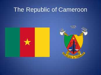
The Republic of Cameroon Cameroon · A unitary republic of central and western Africa · Bordered by Nigeria to the west; Chad to the northeast; the Central African Republic to the east; and Equatorial Guinea, Gabon, and the Republic of the Congo to the south. · Cameroon's coastline lies on the Bight of Bonny, part of the Gulf of Guinea and the Atlantic Ocean. · The country is called "Africa in miniature" for its geological and cultural diversity. History · The territory of present day Cameroon was first settled during the Neolithic · Portuguese sailors reached the coast in 1472 · The German Empire claimed the territory as the colony of Kamerun in 1884 and began a steady push inland.
A half- or full-day fishing trip with a guide, which end up with cooking a meal from the catch, has recently become popular. In one word Canada is a vast country with many diversities and tourist attractions. With its spectacular nature Canada is wonderful. Location. Canada is a huge country in the continent of North America. It is bordered with the Atlantic Ocean in the east, the Pacific Ocean in the west, the United States of America in the south and the Arctic Ocean in the north. Canada is a vast country, with a territory of 3.8 million square miles of land and fresh water it is the second biggest country in the world after Russia. Canada covers most of the northern part of North America. Canada has over 151,480 miles of coastline. Most of Canada's human population lives along its southern border. Geographical facts.
Topic Australia Tallinn English College 2006 Australia 1 . Introduction The name Australia is derived from the Latin Australis, meaning of the south. In land area, Australia is the sixth largest nation, its territory is 7,686,850 sq km and its population reaches today over 20,5 million people. It is the only nation to govern an entire continent and its outlying islands. Australia's capital is Canberra, the only city with its own territory. It was built in the early 1900s just to be the capital. The official language is English and the official name of Australia is the Commonwealth of Australia.
across the country, Canadians experience many different landscapes from rolling plains and mountains to the cold tundra of the north. Despite Canada's great size, it is one of the world's most sparsely populated countries. This fact, coupled with the grandeur of the landscape, has been central to the sense of Canadian national identity. 2. Geographical position Canada is the second largest country in the world after Russia. In the Arctic, Canada reaches almost as far north as Greenland. To the south it extends to the same latitude as southern France. The distance from Canada's west coast, the Pacific Ocean, to its east coast, the Atlantic Ocean, is farther than from North America to Europe. Canada's total land area includes thousands of adjacent islands, notably Newfoundland in the east and those of the Arctic Archipelago in the north. In longitude Canada extends from approximately 52° to 141° W, a distance that spans six time zones
The population of Canada is about 31 million people. About 77% of the people live in cities which lie in a band about 100 miles wide above the border of the United States. The capital of Canada is Ottawa. Other large cities are Montreal, Toronto, Vancouver, Winnipeg and Quebec. 2. Geographical position Canada is a huge country in the continent of North America. It is bordered with the Atlantic Ocean in the east, the Pacific Ocean in the west, the United States of America in the south and the Arctic Ocean in the north. Canada is a vast country, with a territory of 3.8 million square miles of land and fresh water it is the second biggest country in the world after Russia. Canada covers most of the northern part of North America. Canada has over 151,480 miles of coastline. Most of Canada's human population lives along its southern border. 3
nationalities. Besides English and French there are also immigrants from Scotland, Ireland, Wales, Germany, Ukraine and Scandinavia. In Edmonton and Calgary there are also historic Chinatowns, and Calgary has Canada's third largest Chinese community. Geographical features Alberta covers an area of 661,848 square kilometres, an area about 5% smaller than Texas or 20% larger than France. This makes it the fourth largest province after Quebec, Ontario, and British Columbia. To the south, the province borders on the 49th parallel north, separating it from the U.S. state of Montana, while on the north the 60th parallel north divides it from the Northwest Territories. To the east the 110th meridian west separates it from the province of Saskatchewan, while on the west its boundary with British Columbia follows the 120th meridian west south from the Northwest Territories at 60°N until it reaches the Continental Divide at the Rocky Mountains.
USA: West Coast Kristiina Sekljutskaja 11A West Coast · The "West Coast", "Western Seaboard", or "Pacific Coastline" are terms for the westernmost coastal states of the United States. · It most often comprises California, Oregon and Washington. Arizona and Nevada, while not coastal states, are often included due to their proximity to the Pacific Coast and their economic and cultural ties to California · As of 2007, the estimated population of the West Coast ranged from approximately 5060 million, depending on which states are included in the estimate. · Major coastal cities on the West Coast include San Diego, Los Angeles, San Francisco, Seattle, Las Vegas. ·West Coast includes: ·Washington ·Oregon ·Arizona ·Nevada ·California Washington · Named after George Washington, the first President of the United States · Capital: Olympia · Largest city: Seattle
.......................................................................................................... 8 Population and Ethnicity..............................................................................................9 3 Introduction The official name of the country is the United Kingdom. The United Kingdom is an island country. It consists of the island of Great Britain and Northern Ireland. Great Britain can be divided into three parts England, Wales and Scotland. Each of them has their own capital city. Glasgow in Scotland, Cardiff in Wales and London in England. The country is situated in the north-western Europe. The territory of the United Kingdom is about 244,000 square kilometres and about 60 million people live there. The UK contains a number of small islands. The largest islands that belong to the United
Australia Australia is the smallest continent in the world. It is 7.6 million square kilometres big. It is often called the island continent because it is rather small for a continent and very big for an island. There are only five countries bigger than Australia in the World. There are five states in the mainland. Tasmania is also considered as a state so there are six states. The Northern Territory and Canberra are also independent but they are not states. Canberra is the capital of Australia and it is situated between Sydney and Melbourne because both of these cities wanted to be the capital. The population is about 19 million people and growing. New South Wales is
Its territory is about 9.4 million square kilometres and its population is more than 260 million people, 12% of them are the Afro-Americans. It is the world's third-largest country by size and by population. The population density is about 27 people per square kilometre. Most of the people live in towns. There are 50 states in America. The biggest of the state is Texas, next by size are California, Alaska and Montana. Six states - Maine, Vermont, New Hampshire, Connecticut ,Rhode Island and Massachusetts are called New England. They are all small states in the U.S. that lie in the north-east. The first colony of immigrants settled down in Virginia, in the eastern part of the U.S.A. The biggest cities are New York, Washington, Chicago, Los Angeles, San Francisco, etc. The flag of America was adopted on 14 th June 1777. It is called the "Stars and Stripes". It is said that Betsy Ross sewed the first flag. It features 13 horizontal red and
Australia Fact file: Australia comprises a land area of 7 686 850 square kilometres. Its population is about 21,3 million people. Australia's capital is Canberra. The national language is English. The official name of it is the Commonwealth of Australia. It's divided into six states and two territories: New South Wales, Queensland, South Australia, Western Australia, Tasmania, Victoria, Australian Capital Territory (ACT) and Northern Territory. Symbols: Australia had the British flag as their official flag until 1901, when the Commonwealth of Australia was formed. Over 30 000 entries attracted the official competition. Five of them, which contained almost identical designs, were placed equally first. The Australian flag symbolises Australia's historical links with Britain, because it has
Tallinn 2007 FACTFILE Area: 45 228 sq km Poplulation: under 1.4 million Capital: Tallinn Language: Estonian Currency: Eesti kroon (EEK) Main religion: Lutheran National holiday: 24 February (anniversary of the republic) National flower: Cornflower National bird: Barn Swallow National stone: Limestone LOCATION The Republic of Estonia is the northernmost and smallest of the three Baltic States. It is located on the eastern shores of the Baltic Sea in the north east of Europe. To the east the country borders Russia. Latvia is the countries neighbour to the south. From the west the coast of Estonia is washed by the Baltic Sea and from the north by the Gulf of Finland. The length of the coastline is approximately 3 800 km. The longest distance from east to west is 350 km, while north to south Estonia stretches 240 km. THE NAME The name EESTI was apparently derived from the word AISTI, the
So, Australia is both a country and a continent. If you want to make clear that you are speaking about the country, you may call it the Commonwealth of Australia. It’s the official name of the country. Australia is the smallest continent, but one of the largest countries on Earth. It’s 6th largest country. Its area is about 7.6 million sq km. One third of it is occupied by deserts. It’s both the flattest and, except for Antarctica the driest. Neighbouring countries include Indonesia, East Timor and Papua New Guinea in the north, the Solomon Islands, Vanuatu in the northeast, and New Zealand in the southeast. Its capital is Canberra. Other big cities are Melbourne, Sydney, and Brisbane. National language in Australia is English. Monetary unit is Australian dollar. Their national holiday is on the 26th of January. In 1788 on the 26th of January the first fleet arrived at Botany Bay and established a penal colony near modern-day Sydney. Geographical Position
officially the Portuguese Republic, Portuguese: República Portuguesa) is a country located in Southwestern Europe, on the Iberian Peninsula. It is the westernmost country of mainland Europe, and is bordered by the Atlantic Ocean to the west and south and by Spain to the north and east. The Atlantic archipelagos of the Azores and Madeira are Portuguese territory as well. The country is named after its second largest city, Porto, whose Latin name was Portus Cale. SETTLEMENT The land within the borders of the current Portuguese Republic has been continuously settled since prehistoric times
.....................................................9 Vital waterways for people and wildlife..............................................................................................10 2 Introduction If you were asked to show on a world map the regions with the most biodiversity, your finger would probably end up pointing at the Amazon, the Congo Basin or the island of Borneo. But I chose New Guinea, an island that represents no more than 1% of the world's landmass, an array of extraordinary animals and plants have also flourished, such as tree kangaroos and birds of paradise. Close to 10% of the world's vertebrates are concentrated here, while 7% of the world's higher (vascular) plants grow on the island's productive soils. 3 Geography Papua New Guinea consists of over 600 islands and lies in the middle of the long
Ireland (or short United Kingdom)' The population is about 60.4 million. The capital is London. Other biggest cities include Birmingham, Bristol, Portsmouth, Glasgow and Swansea. English is the main language of Great Britain, but Welsh is officially recognized in Wales and Gaelic in Scotland. 2. Geographical position The British Isles is the geographical term for a group of about 5000 islands off the coast of mainland Europe. The largest island is Great Britain, which is also the largest island in Europe. It consists of England, Wales and Scotland. The next largest island is Ireland, which is made up of Northern Ireland and the Irish Republic. Britain and Northern Island together form the United Kingdom. When referring to Britain or Great Britain in everyday life, the names are used to mean the United Kingdom. The English Channel (and best known: the Strait of Dover) separate Britain from
Labour Party, the Liberal Party and National Party. The Senat's membership is wider, it comprises 12 senators from each state and 2 from each territory. Senators are elected for six year terms. The Executive power in Australia is in the hands of the Commonwealth Government lead by the Prime Minister. Today the Prime Minister is John Howard, the leader of the Liberal Party. History Australia was once a part of the giant continent Gondwana. It included Africa, South America and Antarctica. First Australia and Antarctica split from Gondwana, then Australia broke away from Antarctica and began to move north. Aborigines arrived there about 50 000 years ago. They had occupied the whole continent by 30 000 years ago. At that time Tasmania was still part of the mainland. About 20 000 years ago the ice began to melt and the rising water level cut Tasmania off from the mainland. Traders from what is now Indonesia are thought to have been visiting
The highest peak of US is Mt. McKinley in Alaska at ~6000 metrs, while part of Death Valley in California is 89 metres below sea level. At the western edge of the Atlantic coast plain, are almost unbroken mountains, stretching from the Maine into Alabama, called the Appalachian Mountains. These mountains contain coal and iron. The heart of the U.S is a vas plain named interior plains and are divided into two major parts: the wetter, eastern part is called the Central Plains and the western part the Great Plains, both with very good soil. To the west of the Great Plains is the Cordillera. It is a region of tremendous variety, which can be subdivided into various other regions. On the eastern border the Rocky Mountains, a high, discontinuous mountains stretching from Alaska down to Mexico. The western edge of the Cordillera is described by high mountains. The most important ranges are the Sierra Nevada and the Cascades. The U
Australia Australia is a country and also a continent. If someone wants to make clear, that he is speaking of the country, he may call it by its full name of Commonwealth of Australia. Australia's name means "southland."It is south of the equator. Sometimes it is also called the island continent because it is an island. There are about twenty million people in Australia.It is 1,800 miles from the mainland of Asia and almost half way round the world from Europe. More than 600 miles of ocean separate it from Americas. Since Australia is south of the equator, its seasons are just the opposite of ours. It has summer while we have winter, and the other way round. States and Territories. Australia consists of six states, two territories and eight external territories.
Bush. 2. Geographical position The United States of America is located on the continent of North America. It has borders with two countries Mexico and Canada. There are also the Atlantic Ocean, the Pacific Ocean and the Gulf of Mexico surrounding the big country. There are 50 states in America. Most of the people live in towns. The biggest state is Alaska; next by size are California, Alaska and Montana. Six states - Maine, Vermont, New Hampshire, Connecticut, Rhode Island and Massachusetts are called New England. They are all small states in the USA that lie in the north- east. The first colony of immigrants settled down in Virginia, in the eastern part of the USA. 3. Relief The USA is situated in the central part of the North American continent. Its western coast is washed by the Pacific Ocean and its eastern coast is washed by the Atlantic Ocean and in the south its coast is washed by the Gulf of Mexico. The coastline is even. There are no big islands
Ireland is the third largest island in Europe. It lies in between the Atlantic Ocean and the Irish Sea. Politically it is divided into a sovereign state, the Republic of Ireland, that covers about five-sixths of the island (south, east, west and north-west), and Northern Ireland, which is part of the United Kingdom, covering the northeastern sixth of the island.[1] The name 'Ireland' derives from the name Ériu (in modern Irish, Éire) with the addition of the Germanic word 'land'. The population of the island is just under 6 million (2006); just over 4.2 million in the Republic of Ireland[2] (1.6 million in Greater Dublin[3]) and just over 1.7 million in Northern Ireland[4] (0.6 million in Greater Belfast[5])). Politics Politically, Ireland is divided into: · The Republic of Ireland, with its capital Dublin.
Tallinn English College Topic Estonia Tallinn 2008 1. Introduction Estonia is a small country about the size of Switzerland, or New Hampshire and Massachussetts combined. Estonia is named after the people called "Ests" who lived in the region in the 1 st century AD. The Republic of Estonia is one of the three countries commonly known as the "Baltic States". The other Baltic States are Latvia and Lithuania. 2. Geographical position Estonia is situated in northeastern Europe. Estonia is bounded on the north by the Gulf of Finland, on the east by Russia, on the south by Latvia and on the west by the Baltic Sea. In the north it borders on Finland. The coastline of the Baltic
seadusandlik kogu The British Isles is the name of a group of islands washed by the North Sea in the east and the Atlantic Ocean in the west. The British Isles are shared by two separate and independent countries: the United Kingdom of Great
............................................9 12. References....................................................................................................10 Introduction I chose finland because there are friendly people and beautiful nature. Finland is bigger than Estonia. There lives over 5 milj. people. Finland capital is Helsingi and there lives about 2 milj. people. Highest top is 1328m. Finland is bordersed with Sweden to the west, Russia to the east and Norway to the north. It is the eight largest city in Europe. Most Finns speak Finnish. The second language is Swedish. Finland is rated the sixth most peaceful country in the World. In Finland there are more than 60000 lakes. Capital: Helsinki Area: 338145km2 Population: 5200000 Language: Finnish, Swedish Currency: Euro (EUR)
CANADA REVISION QUESTIONS 2010 1. The main physiographic regions of Canada. Canada may be divided into seven physiographic regions: Arctic Lowlands, Cordilleran Region, Interior Plains, Hudson Bay Lowlands, Canadian Shield (Forest Lands), St Lawrence Lowlands and Appalachian Region. Divisions are based on each area's relatively similar physical geography and landforms. Physiographic regionalization is defined here as the process by which regions with relatively homogeneous physical geography are determined 2. Who are the native people of Canada? Into which three groups can they be divided? Canada's constitution specifies three categories of aboriginal peoples: Indian (First Nations), Métis, Inuit. According to Canadian census 2011, 1
The United Kingdom consists of England, Scotland, Wales and North Ireland and it is situated in the Atlantic Ocean near the mainland of Europe. The population of the UK is 58.6 million and area is 244,110 sq km. Britain has a temperate humid climate. Its characteristic features are mild winters, warm summer, no temperature extremes, abundant rain all year round and frequent changes of weather. The mild climate is partly due to the warm Gulf Stream and partly to the south westerly winds. Occasional winds from the east in winter may bring cold and dry weather. The distribution of rainfall is influenced by the Atlantic Stream. The mountainous areas of the north and west have more rain than the lowlands of the south and east. Wales is located on a peninsula in central-west Britain. The entire area of Wales is about 20,779 km². Wales borders by England to the east and by sea in the
depleting the sea otter population. 4. Significance of the Jewish element in Russian immigration to the US. Immigration from Russia to the US in 18811914: Nearly 3.2 million immigrants from the Russian Empire. The most prominent Russian groups that immigrated in this period were the groups seeking freedom from religious prosecution. Nearly half of the immigrants were Jews. Religion of the Russian immigrants: Russian Orthodox, Jews, Nominal Jews (non-religious people of Jewish descent). Eastern European Jews dominated New York's garment industry!!! Immigration in 19201939: A large wave of Russians immigrated in the short time period of 19171922, in the wake of October Revolution and Russian Civil War as refugees from the Bolshevik regime due to the hatred for the new Bolshevik regime in their homeland. Great emphasis was put on education. Most notable immigrants from the cultural sphere were Vladimir Nabokov, Igor Stravinsky, and Isaac Asimov.
Malestrom Major Rivers N am e Continent Out fl o w T o tal Lengt h (mi.) Nile Africa Mediterran ean Sea 4,1 60 Am azo n South Am erica Atlantic Oce an 4,000 Ch ang (Yangtze) Asia East China Sea 3,964 M ississippi-M iss o u ri N o rt h Am eri ca Gul f of Mexico 3,710 Major Deserts