Leidsid 33 sarnast õppematerjali, mis on seotud failiga "Geograafia KT-8.klass". Need materjalid aitavad sul teemat sügavamalt mõista.
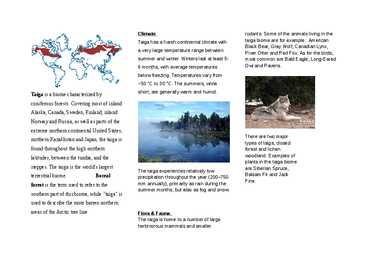
rate, forest, grass, animals, taiga, winter, grow, rainforest, soil, prairie, biome, season, ground, leave, plants, trees, cold, leaves, these, nutrient, here, during, summer, fall, year, protect, other, growing, frost, warm, temperatures, there, cause, weather, drop, fire, days, rich, spring, deep, thin, forests, precipitation, between, snow, summers1. Key features for all studied biomes. Tundra The main seasons are winter and summer. The tundra is the world's coldest and driest biomes. The average annual temperature is -28° C. Nights can last for weeks when the sun barely rises during some months in the winter, and the temperature can drop to -70° C. During the summer the sun shines almost 24 hours a day. Summer are usually warm. Average summer temperatures range from 3° to 16°C. TaigaTaiga is the Russian word for forest and is the largest biome in the world. It stretches over Eurasia and North America. The taiga is located near the top of the world, just below the tundra biome. The winters in the taiga are very cold with only snowfall. The summers are warm, rainy, and humid. Some of the animals in the taiga hibernate in the winter, some fly south if they can, while some just cooperate with the environment. GrasslandsGrassland biomes can be found in the middle latitudes
Temperate deciduous forests, woodlands and shrub Tartu 2008 Location: Temperate forests are typical of all European continent, the Eastern region of Asia (in special, Chinese and Japan) and North America. Also are finded in tempered areas of South America. Climate: The average temperature in temperate forests is 50° F. Summers are mild, and average about 70° F, while winter temperatures are often well blow freezing. The average yearly precipitation is 30-60 inches. This precipitation falls throughout the year, but in the winter it falls as snow. There are four seasons in this biome, with warm summers and cold winters, often snowy. In autumn, the leaves change color and fall from the trees. The leaves decay on the forest floor, so the soil is very rich. Because of this, and because of the long growing season, many deciduous forests have been cut
There are six large areas of temperate grassland: the Pampas in South America, the Veld in Africa, the Canterbury Plains in New Zealand, the Murray-Darling Basin in Australia, the Prairies in North America and the Steppes in Central Asia. 2. Colour the distribution of temperate grassland on the map. 3. How is temperate grassland called in these regions? Eurasia - steppe Hungary - puzda North America - prarie South America - pampa South Africa - veldt 4. What is forest steppe (forest steppe – metsastepp)? A forest steppe is a temperate-climate ecotone and habitat type composed of grassland interspersed with areas of woodland or forest. 5. Describe the climate of temperate grassland. Temperate grasslands have a temperate continental climate, which is cooler than savannas. Temperate grasslands have warm, humid summers with an average temperature of 18° C and cool, dry winters with an average temperature of 10° C. Most of the rain falls as
Tundra Tundra is the world's youngest biome. It was formed 10 000 years ago. Located at latitudes 55° to 70° North. Almost all tundras are located in the Northern Hemisphere, encircling arctic desert and extending south to the coniferous forests of the taiga. The ecotone (ecological boundary region) between the tundra and the forest is known as the tree line or timberline. Tundra comes from the Finnish word tunturi, meaning treeless plain. It is noted for its frost-moulded landscapes, extremely low temperatures, little precipitation, poor nutrients, and short growing seasons. Dead organic material functions as a nutrient pool. The two major nutrients are nitrogen and phosphorus. Nitrogen is created by biological fixation, and phosphorus is created
Different types of forests and their forms of usage TARTU 2010 Forest A forest (also called a wood, woodland, wold, weald, holt, frith) is an area with a high density of trees. Forests cover approximately 30% of land and 9.4% of all the planet earth. They are also responsible for regulating our planet's climate and act as large purifiers of airs, by absorbing carbon dioxide, and giving out oxygen. Different types of forests Forests are divided into following main types: o Tropical forest o Subtropical forest o
Most of Canada's human population lives along its southern border. Geographical facts. Canada's geography is very diverse. It has huge lakes, evergreen forests, prairies, meadows and beautiful mountains. There are thousands of miles of coastline with beaches, fjords and wild rivers flowing to the oceans. Canada is a country of wide open spaces and beautiful landscape where traveling visitors can unexpectedly bump into wild animals like bears or be struck by unusual sight like the scarecrows on the Cabot Trail. Canada is rich in natural wonders, one of them, the Niagara Falls between lakes Erie and Ontario, which is the second biggest waterfall in the world is one of the greatest attractions in the world. About twelve million tourists come to see the beauty of the falling waters on the border between the United States of America and Canada.
151,480 miles of coastline. Most of Canada's human population lives along its southern border. 3. Relief Canada's geography is very diverse. It has huge lakes, evergreen forests, prairies, meadows and beautiful mountains. There are thousands of miles of coastline with beaches, fjords and wild rivers flowing to the oceans. Canada is a country of wide open spaces and beautiful landscape where traveling visitors can unexpectedly bump into wild animals like bears or be struck by unusual sight like the scarecrows on the Cabot Trail. Canada is rich in natural wonders, one of them, the Niagara Falls between lakes Erie and Ontario, which is the second biggest waterfall in the world is one of the greatest attractions in the world. About twelve million tourists come to see the beauty of the falling waters on the border between the United States of America and Canada
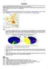
1. What is a biome? A biome is a large area of distinctive plants and animals, which are adapted to that environment. The climate and geography determines which type of biome can exist there. 2. Using the map describe the distribution of the biome (tropical rainforest/tropical deciduous forest). Tropical rainforest South America, Africa (Madagaskar), Asia. Tropical deciduous forest South America, Asia, Australia 3. Compare the climates (tropical rainforest/tropical deciduous forest). Tropical rainforest is wetter than tropical deciduous forest. Both of these biomes have a warm climate all year long. Tropical deciduous forest has a well defined dry and a wet season. During the dry season, the trees in tropical deciduous forest lose their leaves. 4. Using the climate diagram describe the climate of the region (tropical
shown in parentheses): Alberta (Edmonton), British Columbia (Victoria), Prince Edwars Island (Charlottetown), Manitoba (Winnipeg), New Brunswick (Fredericton), Nova Scotia (Halifax), Nunavut (Iqaluit), Ontario (Toronto), Quebec (Quebec City), Saskatchewan (Regina), Newfoundland and Labrador (St. John's), Northwest Territories (Yellowknife) and Yukon Territory (Whitehorse). Geographically, Canada can be divided into five major regions: the Pacific Region, the Prairie Provinces, Central Canada, the Atlantic Provinces and the North. The Pacific Region includes Canada's westernmost province, British Columbia. The region is known for it's mild coastal climate, its forests and its spectacular mountains, including the famous Rockies. Alberta, Saskatchewan and Manitoba are Canada's Prairie Provinces. They are known for their rolling plains and extreme climate with long, cold winters and hot, dry summers. Much of the area is covered with farms producing
Table of contents 1. Introduction 2. Geographical position 3. Mountains, lowlands 4. Rivers, lakes 5. The territories and provinces 6. Towns, economy, agriculture 7. Climate 8. Animals, plantlife 9. Population 10. Sports 11. Culture 12. History 13. Political system, symbols 14. Conclusion 15. Materials 1. Introduction If you had to use two words to describe Canada, they might be large and diverse. Canada is the second largest country in the world, bordered by three oceans, and across the country, Canadians experience many different landscapes from rolling plains and mountains to the cold tundra of the north. Despite Canada's great size, it is
http://www.bbc.co.uk/nature/programmes/tv/jungle/vjungle.shtml Virtual Jungle worksheet I 1. Structure 1.1. Describe these layers Emergents The canopy trees are tall, but some species grow even taller until they stick right out above the canopy. These are called 'emergents' and can reach almost 90m in height. Up here they don't have to compete with other trees for light, but they are exposed to the high winds that lash the canopy during tropical storms. Emergents are the favourite nest sites of jungle eagles such as the harpy eagle of South America. Canopy Suspended 40m above the ground is the canopy - a belt of tree crowns supported by enormous rainforest tree trunks
from 20-25° C. The extreme maximum ranges from 43.5-49° C. Minimum temperatures sometimes drop to -18° C. Rainfall is usually very low and/or concentrated in short bursts between long rainless periods. In semiarid deserts summer temperatures usually average between 21-27° C. It normally does not go above 38° C and evening temperatures are cool, at around 10° C. The average rainfall ranges from 2-4 cm annually. In coastal deserts the average summer temperature ranges from 13-24° C; winter temperatures are 5° C or below. The maximum annual temperature is about 35° C and the minimum is about -4° C. In Chile, the temperature ranges from -2 to 5° C in July and 21-25° C in January. The average rainfall measures 8-13 cm in many areas. The maximum annual precipitation over a long period of years has been 37 cm with a minimum of 5 cm. In cold deserts the mean winter temperature is between -2 to 4° C and the mean summer temperature is between 21-26° C
Savanna A savanna is a grassland ecosystem with scattered trees or shrubs. In savannas trees are small or widely spaced so that the canopy does not close. It is often believed that savannas are characterized by widely spaced, scattered trees, however in many savanna communities tree densities are higher and trees are more regularly spaced than in forest communities. The open canopy allows sufficient light to reach the ground to support an unbroken herbaceous layer consisting primarily of C4 grasses. Savannas are also characterised by seasonal water availability, with the majority of rainfall being confined to one season of the year. Savannas can be associated with several types of biomes. Savannas are frequently seen as a transitional zone, occurring between forest and desert or prairie.
The coat of arms features a kangaroo and an emu (the national animals of Australia), golden wattle (the national floral emblem), a shield with the coats of arms of the six states of Australia and a star for all states and territories. Australia's national anthem is "Advance Australia Fair", which replaced "God Save The Queen" in 1984. the unofficial anthem is "Waltzing Matilda". As said before Australias national animals are kangaroos and emus. Often coalas are mentioned too, its floral emblem is the golden wattle and its national colours are the colours of its flag red, white and blue. Head of state Head of state is Queen Elizabeth II, who is queen of United Kingdom and also queen is Australia. In practice, Governor General performs her functions in queen's absence. Since 1989 Bill Hayden has been the Governor General Government
provinces, the Appalachians, St. Lawrence and Great Lakes lowlands, Canadian Shield, The Prairies, mountain ranges and high plateaus of the Canadian Cordillera, and northern Canada. Climate Canada's climate varies wildly based on geography, from perma-frost in the north to four distinct seasons towards the equator. In this region the temperature can climb up to 35 degrees Celsius in the summer and descend to a chilly -25 degrees Celsius during winter. Canada's climate and environment are one of the main reasons that Canada is such a succesful country. The blend of natural resources and climate sustains us. The seasons dictate the look of the land: according to whether the natural environment is in a state of dormancy or growth. Canada's climate is characterized by its diversity, as temperature and precipitation differ depending on where you are and what time of year it is. Other than the North where it's above
...............................................................................................3 Relief...............................................................................................................................4 Climate & Time Zones....................................................................................................5 Plants...............................................................................................................................5 Animals...........................................................................................................................6 Population.......................................................................................................................6 The Native Australians....................................................................................................6 The Biggest cities..............................................................................................
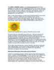
The sunflower (Helianthus annuus) is an annual(iga aastane) plant in the family Asteraceae, with a large flower head (inflorescence(õiekobar, õisik, õitseaeg, õidumine)). The stem(tüvi) of the flower can grow up to 3 metres tall, with the flower head reaching 30 cm in diameter. The term "sunflower" is also used to refer(nimetama, viitama, üle andma) to all plants of the genus(perekond, sugu) Helianthus, many of which are perennial(alaline, aastaringne) plants. What is usually called the flower is actually a head (formally(ametlikult) composite(liit-, komposiit- ; korvõieline, komposiit) flower) of numerous flowers (florets) crowded(täistuubitud, tunglev, rahvarohke) together
Today Australia is a modern developed country with a diversified economy. Australia is an island continent of 7.7 million square kilometres, which makes it a little smaller than the USA. Located in south of Asia, between The Pacific and Indian Oceans, Australia is the World's driest continent. Although large areas of the centre are desert, Australia has a wide range of climate from tropical in the north to temperate in the south east, where it frequently snows in winter. Geographical position The coasts of Australia are surrounded by the Pacific Ocean, the Indian Ocean and the Southern Ocean. Four seas are surrounding Australia, which are the Timor Sea and Arafura Sea in the north of Australia, the Coral Sea in the north-east of Australia and the Tasman Sea, near the island of Tasmania, in the south-east of Australia. Government The full name of the county is the Commonwealth of Australia. Its territory is 7.7 million
Table of content Introduction................................................................................................................................................3 The forests of New Guinea .......................................................................................................................5 The problem with trading wildlife.....................................................................................................6 Animals of the lowlands....................................................................................................................8 Reptiles...................................................................................................................................................8 Crocodiles, leaving New Guinea as skins and back straps ...............................................................9 Vital waterways for people and wildlife.......................................
Estonian University of Life Sciences Report on Soil Microflora By Katrin Vares Tartu 2013 Introduction The purpose of this report is to define soil microflora and establish the importance of it. Since the microorganisms clearly play an important role in preserving the balance of life, the next objective is to look into factors that influence this balance. Natural conditions and cultural impact could be considered as the variables that correlate the most with the activity and composition of microflora, hence some of the natural and cultural factors will be looked into a little more in detail.
an island but rather small for a continent. Australia is 1,800 miles from the mainland of Asia and almost half way round the world from Europe. More than 6,000 miles of ocean separate in from the America. Australia is the only continent except for Antarctica that lies all south of the equator. The natural zones of Australia are very various. There are deserts, semi deserts, grasslands, savannas, bushlands and rainforests. The wet forests occupy the narrow region in the east. Most of the animals, birds and insects live in that region, because there is enough food. The savannas which are grasslands with some trees are mostly in the west. Farther west are the bushlands. The real deserts occupy the centre of the Western Plateau. In the very south west there are thin forests of evergreens trees. Australia is the driest inhabited continent, the flattest, and has the oldest and least fertile soils. Only the south-east and south-west corners of the continent have a temperate climate
Thes fertile farmlands contrast vividly with the Arctic wastelands to the north. Most of the largest towns and industrial areas lie near the Great Lakes and the St Lawrence River in central Canada. In the east, fishing villages and sandy beaches dot the Atlantic coast. Across the country, Canadians experience many different landscapes from rolling plains and mountains to the cold tundra of the north. Geographically, Canada can be divided into five major regions : the Pacific Region, the Prairie Provinces, Central Canada, the Atlantic Provinces, and the North. The Pacific Region includes Canada's westernmost province, British Columbia. The region is known for its mild coastal climate, its forests, and its spectacular mountains, including the famous Rockies. The Rocky Mountains are the youngest and highest mountains in Canada. British Columbia is in the landform region called the Western Cordillera. ('Cordillera' means a system of mountain ranges)
4 On the territory of the USA the mountain ranges stretch in the north-south direction. The first from the east are the Rocky Mountains. West of the Rockies lie vast plateaus and tablelands: the volcanic Columbia Plateau, the Great Basin, the Colorado Plateau. Further west is a narrow belt of the Cascade Mountains, and the Sierra Nevada Range Still further west lies an area of valleys. The forests cover 30% of the US. In the southern part of Alaska grow coniferous trees, notably spruces and firs. Around the Great Lakes and New England are mixed forests of pines, maples, elms, birches, oaks and beeches. Along the Gulf of Mexico grow magnolia, red and black gum, cypress and mangrove. Geographical Regions The territory of the United can be divided into eight regions: 1) New England; 2) the Mid-Atlantic region; 3) the South; 4) the Midwest; 5) the Southwest; 6) the Rocky
transporting such products as coal, iron ore and steel. The largest lake in Great Britain, Loch Lomond, lies in Scotland. There are many lakes in Scotland. They are narrow and long in shape because of the mountains. Loch Ness is well-known for its mysterious monster. 6 Climate Britain has a maritime temperate climate which means that it's quite mild, with temperatures not much lower than 0ºC in winter and not much higher than 30ºC in summer. There are no extremes of temperature, abundant rainfall all the year round and frequent changes of the weather. English people often complain about their weather. The mild climate is due to the warm Gulf Stream. Occasional winds from the east in winter bring cold and dry weather. The mountainous areas of the north and west have mare rain than the lowlands of the south and east. The best time to visit England is from May to September.
They would eventually become the provinces of Ontario and Quebec in 1867. Regions in Canada Canada is divided into five major regions. The Pacific Region The Pacific Region consists of only one province - British Columbia. It is known for its mild coastal climate, forests and the Rocky Mountains. The Rocky Mountains are the youngest and the highest mountains in Canada. Largest cities are Vancouver and Victoria. Only 5% of The Pacific Region is inhabitable. The Prairie Provinces The Prairie Provinces consists of Alberta, Saskatchewan and Manitoba provinces. Population in that region is about 5.7 million people. The precipitation in The Prairie Provinces is very low only 400 mm per year. The biggest cities are Calgary, Winnipeg and Saskatoon. The Prairie Provinces focus on farming. 95% of the land in that region has been converted into farmland. Mostly wheat and other grains are produced. Cattle and sheep ranching is also part of the agriculture. The
Climate rodants. Some of the animals living in the Taiga has a harsh continental climate with taiga biome are for example: American Black Bear, Gray Wolf, Canadian Lynx, a very large temperature range between River Otter and Red Fox. As for the birds, summer and winter
One of these lakes, Saimaa, is the fifth largest in Europe. The Finnish landscape is mostly flat with few hills and its highest point, the Halti at 1,324 metres, is found in the extreme north of Lapland at the border between Finland and Norway. The landscape is covered mostly (seventy-five percent of land area) by coniferous taiga forests and fens, with little arable land. The most common type of rock is granite. It is a ubiquitous part of the scenery, visible wherever there is no soil cover. Moraine or till is the most common type of soil, covered by a thin layer of humus of biological origin. The greater part of the islands are found in southwest in the Archipelago Sea, part of the archipelago of the Åland Islands, and along the southern coast in the Gulf of Finland. Finland is one of the few countries in the world whose surface area is still growing. Owing to the post-glacial rebound that has been taking place since the last ice age, the
Australia's name means "southland."It is south of the equator. Sometimes it is also called the island continent because it is an island. There are about twenty million people in Australia.It is 1,800 miles from the mainland of Asia and almost half way round the world from Europe. More than 600 miles of ocean separate it from Americas. Since Australia is south of the equator, its seasons are just the opposite of ours. It has summer while we have winter, and the other way round. States and Territories. Australia consists of six states, two territories and eight external territories. The six states are: Western Australia (capital Perth), South Australia (capital Adelaide), Queenslnd (capital Brisbane), New South Wales (capital Sydney), Victoria (capital Melbourne) and Tasmania (capital Hobert). The two territories are the Northern territory (capital Darwin) and the Capital territory (capital Canberra). Politics
The Prime Minister is really the head of government in Canada. Stephen Harper is currently the PM. National symbols. The use of the maple leaf as a Canadian symbol dates back to the early 18th century, and is on its current and previous flags, the penny, and on the coat of arms. The national colours are red and white which also appear on the flag. The national animal is the beaver and it is because the fur trade. Maple syrup is very important for Canadians also. Hockey is the official winter sport. Canada's official colours are red and white. The colours appear on the flag. History. Almost a thousand years ago men from Norway sailed across the Atlantic Ocean and "discovered" America about 4 centuries before Columbus. In 985 AD Vikings who wanted to go to Greenland from Iceland were blown off their course and they reached Canada. It is thought that they reached Labrador. They saw forested areas there and further exploration were encouraged by this discovery because the
In London you'll also find Indonesian, Mexican, Greek... Cynics will say that this is because English have no "cuisine" themselves, but this is not quite the true. Vocabulary: to criticize - tasteless overcooked - ingredient - to invent - sauces - to disguise - spice herb - delicious - disappointing - to lend cuisine British Youth (2) Most 18 and 19 year-olds in Britain are quite independent people. English people say that children grow up more quickly now. Relationships within the British family are different now. Children have more freedom to make their own decisions. For example, children aged 13 may be employed part time in Great Britain. Age 15 is legally a "young person" not a "child". Age 16 is a school leaving age. They can leave home, drive a moped, marry with "parents' consent" buy beer. Age 17 can drive a car. Age 18 can vote, get married, drink in pubs.
Robert Angus Smith, in 1852. In that year, he discovered the relationship between acid rain and atmospheric pollution in Manchester, England. Although it was discovered in the 1800s, acid deposition did not gain significant public attention until the 1960s and the term acid rain was coined in 1972. Public attention further increased in the 1970s when the New York Times published reports about problems occurring in the Hubbard Brook Experimental Forest in New Hampshire. Effects of Acid Rain Today there are several important impacts of acid deposition on both natural and man-made environments. Aquatic settings are the most clearly impacted by acid deposition though because acidic precipitation falls directly into them. Both dry and wet deposition also runs off of forests, fields, and roads and flows into lakes, rivers, and streams. As this acidic liquid flows into larger bodies of water, it is diluted but over time, acids can
Environmental effects Very obvious environmental effect of acid rain is the loss of fish in acid sensitive lakes and streams. Loads of fishes are not able to survive in acidic water. There are 2 ways acid rain effects lakes and streams: chronic and episodic. The first one is long-term process and this acidification is result from years of acidic rainfall. Episodic, on the other hand, is rapid change sudden jump in the acidity of water. Acid deposition may influence forest vegetation and soils. It removes soil nutrients such as calcium and magnesium from soils in high elevation forests. Acid rain may also help weaken natural defenses of some trees, making them more vulnerable to some diseases and pests. Acid rain wears away the waxy protective coating of leaves, damaging them and preventing them from being able to photosynthesize properly. Many animals and insects are sensitive to acidification
Because Estonia is continuously warmed by the Gulf Stream it has a milder climate despite its northern latitude. Northern latitude means long summer daylight hours (the longest summer day stretches to 19 hours), and dark winters when daylight lasts sometimes only six hours. Being on the Baltic Sea the country is subjected to sea breezes and humidity. Estonia has a temperate climate, with four seasons of near-equal length. Summer is warm, while spring and autumn can be mild. Winter, which lasts from November to middel March, 4 can be very cold. The cold winter does not necessarily mean constant snow; in fact snowfalls are few and far between. When it falls it stays though, and there tends to be a layer of snow on the ground constantly. The deepest snow cover is usually in the south-eastern part of Estonia. Temperatures range from a summer average of 30°C to an average in winter of -8°C.The