Leidsid 33 sarnast õppematerjali, mis on seotud failiga "Essee teemal Tiibet". Need materjalid aitavad sul teemat sügavamalt mõista.
tibet, china, region, part, west, westernast, mount, north, government, dalai, chinese, lama, republic, cultural, buddhism, asia, language, influence, amdo, lhasa, plateau, other, independent, ruled, during, regard, including, south, several, mountain, nepal, year, regionsastern, northern, tsang, center, religion, traditional, heritageven, thoughTeams of twenty or thirty oxen were strained to pull blocks on specially constructed wagons. The plinth and tomb took roughly 12 years to complete. The remaining parts of the complex took an additional 10 years. Facts: The Taj Mahal was constructed using materials from all over India and Asia. Over 1,000 elephants were used to transport building materials during the construction. The translucent white marble was brought from Rajasthan, the jasper from Punjab, jade and crystal from China. The turquoise was from Tibet and the Lapis lazuli from Afghanistan, while the sapphire came from Sri Lanka and the carnelian from Arabia. In all, twenty eight types of precious and semi-precious stones were inlaid into the white marble. Exterior decoration The exterior decorations of the Taj Mahal are among the finest to be found in Mughal architecture. As the surface area changes, a large pishtaq has more area than a smaller one, and the decorations are refined proportionally
officially the Portuguese Republic, Portuguese: República Portuguesa) is a country located in Southwestern Europe, on the Iberian Peninsula. It is the westernmost country of mainland Europe, and is bordered by the Atlantic Ocean to the west and south and by Spain to the north and east. The Atlantic archipelagos of the Azores and Madeira are Portuguese territory as well. The country is named after its second largest city, Porto, whose Latin name was Portus Cale. SETTLEMENT The land within the borders of the current Portuguese Republic has been continuously settled since prehistoric times
mountain peaks. There are two big mountain ranges, one of them is the Rocky Mountains and the other is The Appalachian Mountains. The Capital of The USA is Washington D.C. Other big and famous cities are New York, Los Angeles, Houston, Chicago and Las Vegas. The national anthem of the United States is "The Star-Spangled Banner", with lyrics written in 1814 by Francis Scott Key. There are 6 time zones. From east to west they are: Eastern Standard Time, which is 5 hours behind Greenwich Time, Central Standard Time, Mountain Standard Time, which is 7 hours behind Greenwich Time, Pacific Standard Time. Alaska and Hawaii have their own time zones: Alaska Standard Time and Hawaii Standard Time. Geographical Position The USA lies in the Northern Hemisphere in North America. It covers a big part of the continent and is also the third largest country in the world. The country consists of 50 states, but two of them
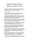
" Born in 1946 in a village in the northern Italian province of Gorizia, near the border with the then Yugoslavia, Capello insists a hardworking upbringing and the encouragement of his father to pursue his footballing dreams are the roots of his success. His father played for an Italian third division side and an uncle was so good that he played for the national side. Not only was football in the genes but it also provided an escape from the Cold War pressures in a part of Italy where there was constant fear that the borders could be redrawn and his family forced from their home. Citing the role of his father and uncle in forming his legendary work ethic, Capello said: "They taught me dedication, to always work hard with absolute stubbornness. Only hard work allows an athlete to make the most of his talents." The result is a Stakhanovite philosophy under which Capello rewards the players he
and it is bordered by three oceans: the Arctic, the Pacific and the Atlantic Oceans. The population of Canada is about 31 million people. About 77% of the people live in cities which lie in a band about 100 miles wide above the border of the United States. The capital of Canada is Ottawa. Other large cities are Montreal, Toronto, Vancouver, Winnipeg and Quebec. 2. Geographical position Canada is a huge country in the continent of North America. It is bordered with the Atlantic Ocean in the east, the Pacific Ocean in the west, the United States of America in the south and the Arctic Ocean in the north. Canada is a vast country, with a territory of 3.8 million square miles of land and fresh water it is the second biggest country in the world after Russia. Canada covers most of the northern part of North America. Canada has over 151,480 miles of coastline
In 1890, 40 % of Irish people were living abroad "Exodus in reverse" has been used to describe Irish people returning to Ireland, especially from the US. Immigration from many countries, but mostly from Poland, the UK, Lithuania, Latvia, Nigeria and Romania. Is Ireland still an emigration country? No 7. What is the difference between the Irish Free State and the Republic of Ireland? All three names refer to the same country (Northern Ireland was part of the Irish Free State for one day, if you want to be really pedantic). The Irish Free State was established in 1922. It was part of the British Commonwealth, and a dominion of the UK, with which it shared a monarchy. Before this, all of Ireland was a part of the UK. In 1937, Irish voters backed a plebiscite which voided the Anglo-Irish Agreement (which created the Irish Free State), changed the country's name to Ireland, and set in motion the formal
Geography Canada is the world's second largest country in total area after Russia , since it covers nearly 10 million square kilometres, but is one of the most sparsely populated, with only about 34 million inhabitants. The majority of them live within 300 kilometres of Canada's southern border. Much of the rest of Canada is uninhabited or thinly populated, because the country has a rugged terrain and severe climate. Canada extends across the continent of North America, from Newfoundland on the Atlantic coast to British Columbia on the Pacific coast and northward into the Arctic Ocean. Canada shares land borders with the United States to the south and north-west. Canada is a land of great variety. Towering mountains, crystal-clear lakes, and lush, green forests make Canada's far west a beautiful region. Farther inland, fields of wheat and other grains cover Canada's vast prairies
Chinese americans Chinese Americans (traditional Chinese or simplified Chinese) are Americans of Chinese descent. Chinese people came to the United States from Singapore, Vietnam, Malaysia, Indonesia, Burma, the Philippines, and Taiwan.[6] The first Chinese immigrants arrived in 1820 according to U.S. government records. 325 men are known to have arrived before the 1848California Gold Rush[7] which drew the first significant number of laborers from China who mined for gold and performed menial labor.[8] [9][10] There were 25,000 immigrants by 1852, and 105,465 by 1880, most of whom lived on the West Coast. They formed over a tenth of California's population. Nearly all the early
....................................................................18 2 Introduction The aim of this research is to get know more about the Netherlands history and its geographical facts. This report is describing one of most the most beautiful countries in the Europe - Netherlands. Netherlands is famous for its windmills and flowers. Netherlands is also known unofficially as Holland. Government is constitutional monarchy of north-western Europe. Netherlands is bordered on the north and west by the North Sea, on the east by Germany and on the south by Belgium. The European portion of the Netherlands has a total area of 41,528 sq km of which 33,939 sq km is land surface. Country's capital and largest city is Amsterdam. Population is about 16 million. 3 Chapter 1
The capital city is Washington D.C. Although the United States has no official language at the federal level, English is the de facto national language. English is the most common language for daily interaction among both native and non-native speakers. Spanish is the second language. The largest city is the New York City. The Government is Federal constitutional republic and the president is George W. Bush. 2. Geographical position The United States of America is located on the continent of North America. It has borders with two countries Mexico and Canada. There are also the Atlantic Ocean, the Pacific Ocean and the Gulf of Mexico surrounding the big country. There are 50 states in America. Most of the people live in towns. The biggest state is Alaska; next by size are California, Alaska and Montana. Six states - Maine, Vermont, New Hampshire, Connecticut, Rhode Island and Massachusetts are called New England. They are all small states in the USA that lie in the north- east
SOCIETY AND CULTURE OF ENGLISH-SPEAKING COUNTRIES Introduction 1. Nowadays, English is so widely spoken that it can hardly be considered "a one nation's" language. The main countries where English is spoken are: the U.K, the U.S, Canada, Australia, the Republic of Ireland, New Zealand, West Indies 2. There are approx. 300-400 million speakers of English in the world. English occupies the 3rd place by its number of speakers; it is right behind Mandarin and Spanish. 3. ESL (English as a Second Language) used in your own country (e.g. India) EFL (English as a Foreign Language) used in a foreign country ESP (English for Specific Purposes) used in business, airlines, hotels etc. 4
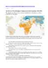
8 billion, or 30% of the population) and Christians (2.9 billion, or 31%), possibly for the first time in history.2 With the exception of Buddhists, all of the world’s major religious groups are poised for at least some growth in absolute numbers in the coming decades. The global Buddhist population is expected to be fairly stable because of low fertility rates and aging populations in countries such as China, Thailand and Japan. Worldwide, the Hindu population is projected to rise by 34%, from a little over 1 billion to nearly 1.4 billion, roughly keeping pace with overall population growth. Jews, the smallest religious group for which separate projections were made, are expected to grow 16%, from a little less than 14 million in 2010 to 16.1 million worldwide in 2050.
Approximately 20,000 Displaced Persons arrived in the US. Immigration in 1969-...: the Soviet Union temporarily loosened emigration restrictions for Jewish emigrants, which allowed nearly 250,000 people leave the country, escaping covert anti-semitism. Jews were allowed to leave Russia for Israel, but many had the US as their real goal. Most had no knowledge of Yiddish or Hebrew or the Jewish religion. Immigration after 1985: the Soviet government under Mikhail Gorbachev allowed anyone to leave the Soviet Union. The major group of post-Soviet immigrants were the political refugees, persons who claim persecution or reasonable fear of persecution in Russia. Largest Russian communities today are in New York, California and Florida. 5. From where did the Indians come to America? *Native Americans aka. Indians, Red Indians, Redskins, American Indians, Amerindians, Namerind, First Nations people (Canada) *Origins of N-Am, theories =
books his parents sent him including Daniel Defoe's Robinson Crusoe. Wilkie Collins' The Moonstone and works by the likes of Ralph Waldo Emerson and Bret Harte also left an indelible impression on Kipling. Respite from the Holloway household was gained when he spent one month a year in London with his mother's kindly sister Aunt Georgie and her husband, pre-Raphaelite painter Edward Burne Jones and their children. Those months of December were a veritable paradise to Kipling; North End House was constantly brimming with visiting friends and relatives, and the homey and artistic effects of the affectionate couple were everywhere. Their home echoed with laughter and the patter of little feet or was eerily hushed as the children raptly listened to fantastic stories told by Edward. They also played the organ, sang songs, dressed up in costumes and acted out plays. In January 1878 Kipling was admitted to the United Services College, at Westward Ho!, Devon, a school
It was built in the early 1900s just to be the capital. The official language is English and the official name of Australia is the Commonwealth of Australia. Australia is located on the Southern Hemisphere (because of that Australia is also called "A land down under"). 2 . Geographical position Australia is an island continent and it is located between the Indian and South Pacific oceans south east of Asia. From the north it is bordered by the Timor Sea and the Torres Strait. From the east by the Coral Sea and the Tasman Sea. Australia's coastline is about 37,000 km long. The Great Australian Bight washes the southern coast. The Gulf of Carpenteria and the Cape York Peninsula surround it in the south. 3. Relief Australia is the smallest continent in the world It is often called the island continent because is too big for an island but rather small for a continent
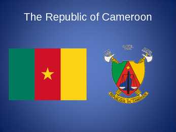
The Republic of Cameroon Cameroon · A unitary republic of central and western Africa · Bordered by Nigeria to the west; Chad to the northeast; the Central African Republic to the east; and Equatorial Guinea, Gabon, and the Republic of the Congo to the south. · Cameroon's coastline lies on the Bight of Bonny, part of the Gulf of Guinea and the Atlantic Ocean. · The country is called "Africa in miniature" for its geological and cultural diversity. History · The territory of present day Cameroon was first settled during the Neolithic · Portuguese sailors reached the coast in 1472 · The German Empire claimed the territory as the colony of Kamerun in 1884 and began a steady push inland. · An economic crisis took effect in the mid-1980s to late
Imperialism: empires got bigger and with that the competition between the empires grew. Everyone wanted more areas for themselves. Militarism: at the start of 20th century, an arms race had started. Nations had more technology and manpower than ever before and started making armies and new weapons. Nationalism: Much of the origin of the war was based on the desire of the Slavic peoples in Bosnia and Herzegovina to no longer be part of Austria-Hungary but instead be part of Serbia. But in a more general way, the nationalism of the various countries throughout Europe contributed not only to the beginning but the extension of the war in Europe. Each country tried to prove their dominance and power. Assassination of Archduke Franz Ferdinand: In June 1914, a Serbian nationalist assassinated him and his wife while they were in Sarajevo, Bosnia which was part of Austria-Hungary
CANADA REVISION QUESTIONS 2010 1. The main physiographic regions of Canada. Canada may be divided into seven physiographic regions: Arctic Lowlands, Cordilleran Region, Interior Plains, Hudson Bay Lowlands, Canadian Shield (Forest Lands), St Lawrence Lowlands and Appalachian Region. Divisions are based on each area's relatively similar physical geography and landforms. Physiographic regionalization is defined here as the process by which regions with relatively homogeneous physical geography are determined 2. Who are the native people of Canada? Into which three groups can they be divided? Canada's constitution specifies three categories of aboriginal peoples: Indian (First Nations), Métis, Inuit. According to Canadian census 2011, 1
From the beginning The oldest evidence of human habitation in the Prague valley dates from 600, 000 BC, but more numerous clues were left by hunters during the last Ice Age, about 25, 000 years ago. Permanent communities were established around 4000 BC in the northwestern parts of Prague, and the area was inhabited continuously by various Germanic and Celtic tribes before the arrival of the Slavs. The name Bohemia came from a Celtic tribe called Boii, and is still used today for the western part of the Czech Republic. Foundation of Prague In the 6th century, two Slav tribes settled on opposite sides of a particularly appealing stretch of the Vltava River. The Czechs built a wooden fortress where the residential area Hradcany stands today, and the Zlícani built theirs upstream at what is now Vysehrad. They had barely dug in when nomadic Avars thundered in, to rule until the Frankish trader Samo united the Slav tribes and drove the Avars out
Introduction Estonia, officially the Republic of Estonia (Estonian: Eesti or Eesti Vabariik) is a country in the Baltic region of Northern Europe. It is bordered to the north by Finland across the Gulf of Finland, to the west by Sweden across the Baltic Sea, to the south by Latvia (343 km), and to the east by the Russian Federation (338,6 km). The territory of Estonia covers 45,227 km² and is influenced by a temperate seasonal climate. The Estonians are a Finnic people closely related to the Finns, with the Estonian language sharing many similarities to Finnish. The modern name of Estonia is thought to originate from the Roman historian Tacitus, who in his book Germania (ca.
like dietary laws and banking to warfare. Almost all Muslims belong to one of two major denominations, the Sunni and Shi'a. The schism developed in the late 7th century following disagreements over the religious and political leadership of the Muslim community. Roughly 85 percent of Muslims are Sunni and 15 percent are Shi'a. Islam is the predominant religion throughout the Middle East, as well as in parts of Africa and Asia. Large communities are also found in China, the Balkan Peninsula in Eastern Europe and Russia. There are also large Muslim immigrant communities in other parts of the world such as Western Europe. About 20 percent of Muslims live in Arab countries. Etymology and meaning The word Islm, from the triliteral root slm, is derived from the Arabic verb Aslama, which means "to accept, surrender or submit." Thus, Islam means acceptance of and submission to
Tallinn English College Topic Estonia Tallinn 2008 1. Introduction Estonia is a small country about the size of Switzerland, or New Hampshire and Massachussetts combined. Estonia is named after the people called "Ests" who lived in the region in the 1 st century AD. The Republic of Estonia is one of the three countries commonly known as the "Baltic States". The other Baltic States are Latvia and Lithuania. 2. Geographical position Estonia is situated in northeastern Europe. Estonia is bounded on the north by the Gulf of Finland, on the east by Russia, on the south by Latvia and on the west by the Baltic Sea. In the north it borders on Finland. The coastline of the Baltic
Mari-Liis Pakats Tallinn 2008 2 Table of Contents Introduction..................................................................................................................4 Geographical Position .................................................................................................4 History .........................................................................................................................4 Government..................................................................................................................5 Queen Victoria.............................................................................................................5 Relief............................................................................................................................6 Climate ...............................................................................................................
The current coat of arms of Estonia is a golden shield which includes three slim, blue leopards (or lions) in the middle, with oak branches along the side of the shield. It originates from Denmark. It was officially adopted in 1925. Geography Estonia is the northernmost of the three Baltic States. It is located on the northern hemisphere on the eastern shores of the Baltic Sea in the north-east of Europe. It has land contact with Russia from the east and Latvia from the south. In the north The Gulf of Finland separates Estonia from Finland. The Gulf of Riga is situated to the south-west. Estonia has more than 1500 islands. The biggest ones are located to the west. The four biggest islands are Saaremaa, Hiiumaa, Vormsi and Muhu. The highest point in Estonia and also in the Baltic region is Suur Munamägi. It is 318. above sea level. Estonia is a country of a thousand lakes. The Largest one is Lake Peipsi which is also the fourth biggest freshwater lake in Europe
Ireland is the third largest island in Europe. It lies in between the Atlantic Ocean and the Irish Sea. Politically it is divided into a sovereign state, the Republic of Ireland, that covers about five-sixths of the island (south, east, west and north-west), and Northern Ireland, which is part of the United Kingdom, covering the northeastern sixth of the island.[1] The name 'Ireland' derives from the name Ériu (in modern Irish, Éire) with the addition of the Germanic word 'land'. The population of the island is just under 6 million (2006); just over 4.2 million in the Republic of Ireland[2] (1.6 million in Greater Dublin[3]) and just over 1.7 million in Northern Ireland[4] (0.6 million in Greater Belfast[5])). Politics Politically, Ireland is divided into:
Tallinn English College Report of Canada 8a Teacher: Merike Sisask Composer: Kärt Kalvet 2010 Canada, Kärt Kalvet 8a Canada General Information Canada is in North America. It's area is 9220970 sq km. Canada's population is 313.612.000 people. Canada is divided into 10 provinces and 3 territories. The capital of Canada is Ottawa. Canada has constitutional monarchy. The head of state in Canada's government is the Queen of England. There are two main languages in Canada: English and French. Canada's curreny is Canadian dollar (1 dollar=100 cents[Can$]). The highest peak of Canada is Mount Logan, 5959 metres. The lowest point is sea level. The longest river is the Mackenzie. The climate and geography of Canada vary greatly from temperate in the south to arctic in the north and from islands and plains in the east to mountains in the west. Location
Wales, Germany, Ukraine and Scandinavia. In Edmonton and Calgary there are also historic Chinatowns, and Calgary has Canada's third largest Chinese community. Geographical features Alberta covers an area of 661,848 square kilometres, an area about 5% smaller than Texas or 20% larger than France. This makes it the fourth largest province after Quebec, Ontario, and British Columbia. To the south, the province borders on the 49th parallel north, separating it from the U.S. state of Montana, while on the north the 60th parallel north divides it from the Northwest Territories. To the east the 110th meridian west separates it from the province of Saskatchewan, while on the west its boundary with British Columbia follows the 120th meridian west south from the Northwest Territories at 60°N until it reaches the Continental Divide at the Rocky Mountains.
cultural diversity of different nations in Canada. All the communities living in the country are encouraged to remember their origins and hold their own ethnic events and national festivals. Cultural diversity makes Canada even more interesting. In spite of this, in recent years there is a strong movement in French-speaking Quebec to become an independent country. There are many different native people throughout Canada like the Crees, Mohawks, Troquois and Sioux. In the north of the country, the Inuit (Eskimos) now have a self-governing homeland called Nunavut, meaning our land. It is over two million square kilometers and it is inhabited by 17,500 Inuits. The national symbol of Canada is the maple leaf. The national tree is the maple. Canada is also the most tolerant societies in the world because only 13% of Canadians say that they would object their children marrying somebody of a different race, compared with 32% in the USA.
The United Kingdom The United Kingdom consists of England, Scotland, Wales and North Ireland and it is situated in the Atlantic Ocean near the mainland of Europe. The population of the UK is 58.6 million and area is 244,110 sq km. Britain has a temperate humid climate. Its characteristic features are mild winters, warm summer, no temperature extremes, abundant rain all year round and frequent changes of weather. The mild climate is partly due to the warm Gulf Stream and partly to the south westerly winds. Occasional winds from the east in winter may
CANADA Canada is a vast country, second largest country of the world after Russia. It stretches from the Atlantic Ocean in the east to the Pacific Ocean in the west and to the Arctic Ocean in the North. Canada Covers most of the northern part of North America and its geography is very diverse. Canada's area is about 10 million square kilometers and its population is 31 000 000. Its capital is Ottowa and other main cities are Toronto, Montreal and Vancouver. Almost 75 % of canadians lives within 300 kilometer of the USA border, because the climate is softer in the South. 89 % of Canada is almost unhabited. Its official languages are English and French, but many other languages are spoken too
in 1984. Before the proclamation, Australia had no official colour, although three colour combinations traditionally had a claim to be Australia's national colours: red, white and blue; blue and gold; and green and gold. Head of State: The Head of State is the Queen of United Kingdom, who is also the Queen of Australia. In practise, Governor-General performs her functions in queen's absence (now, Governor-General is Quentin Pryce and she is the 25th.) Government: The form of the government is constitutional monarchy, in practice, parliamentary democracy. The Parliament consists of two houses: the 76-member Senate and the 148- member House of Representatives. The Prime Minister is elected by the House of Representatives and the Cabinet. The current Prime Minister is Kevin Rudd. History, discovery: Though nobody had seen it, people thought long before the seventeenth century, that there was a land in the southern ocean
.....................................................................................8 Sports..............................................................................................................................9 Culture.............................................................................................................................9 History.............................................................................................................................9 Government...................................................................................................................10 Conclusion....................................................................................................................11 Materials........................................................................................................................11 2
peace and human development, while others have called the organization ineffective, corrupt, or biased. 2. General knowledge on your delegation COUNTRY: Syrian Arab Republic POPULATION: Over 13 million LANGUAGE: Arabic (official); French; English RELIGION: Islam, Christianity, Druze, Judaism, Baha'i Syrian Arab Republic, more commonly known as Syria. The fertile land of Syria lies at the crossroads of great trade routes between the East and West. It is also the site of many holy places in Judaism, Christianity, and Islam. Because of these advantages, it has been invaded, conquered, and occupied by many different peoples over its long history. These groups include the Egyptians, Babylonians, Persians, Greeks, Romans, Arabs, European Crusaders, Mongols from Central Asia, Turks, British, and French. In 1946, the French gave up control over Syria, and the Syrian Arab Republic was created.