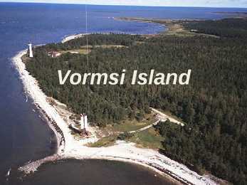
Vormsi was inhabited by coastal Swedes 2500 people lived there before WWII During the Soviet occupation Vormsi was a closed border-zone Blend of Soviet and Swedish history mixed with unspoilt nature Nowadays Celtic crosses from the 13th century in Vormsi cemetery Vormsi is for people interested in mixed Soviet and Swedish history and rare nature Landscape Juniper fields Seaside meadows Erratic borders Lighthouses Forests Bays Lagoons To get to Vormsi You have to take a ferry (12 km, 45 min.) from Rohuküla port Public transportation between port and island's centre Hullos There aren't any gas stations in Vormsi! ur r yo f o o u k y d io n a n a n n t Th c e t t e ) i en le a a s m at ab a r c
Estonian landscapes and the national heritage of the area. This was the first national park in Estonia. It is located on Northern Estonia, 70 kilometers east from capital Tallinn. Its area covers 725 km², including 250.9 km² of sea. The name Lahemaa originates from the most thoroughly studied and visited part of the North-Estonian coast, where four large peninsulas (Juminda, Pärispea, Käsmu and Vergi) are separated from each other by four bays (Kolga, Hara, Eru and Käsmu.) Lahemaa translates roughly as "Land of Bays". 8. Kadriorg Palace Catherinethal ("Catherine's valley") is a Petrine Baroque palace of Catherine I of Russia in Tallinn, Estonia. It was built after the Great Northern War to Nicola Michetti's. Catherinethal was abandoned by Russian royalty throughout the late 18th and 19th centuries. In the 1930s Konstantin Päts, Estonia's first president, embarked on
Baltic Sea. Average elevation reaches only 50 meters and the country's highest peak is the Suur Munamägi in the southeast at 318 meters.Estonia boasts over 1,400 lakes. Most are very small, with the largest, Lake Peipus, (Peipsi in Estonian) being 3555 km². There are many rivers in the country. The largest are the Võhandu (162 km), Pärnu (144 km), and Põltsamaa (135 km). Estonia also boasts numerous bogs, and 3794 kilometers of coastline marked by numerous bays, straits, and inlets. The number of islands and islets is estimated at some 1,500. Two are large enough to constitute their own counties: Saaremaa and Hiiumaa. Estonia lies in the northern part of the temperate climate zone and in the transition zone between maritime and continental climate. Because Estonia is continuously warmed by the Gulf Stream it has a milder climate despite its northern latitude. The Baltic Sea causes differences between the climate of coastal and inland areas
The Republic of Estonia Estonia lies on the shores of the Baltic Sea. Its nearest neighbours are Finland, Sweden, Latvia and Russia. The total are of Estonia is 45,215 square kilometres. Estonia is one of the most sparsely populated countries in Europe. It has population neraly 1.4 million. There are lot of bays and peninsulas along the coast of Estonia.It has about 1,200 islands, the largest of which are Saaremaa and Hiiumaa. Nort-estonia is relatively flat and low-lying. There is a nice coastline here. Sout- estonia is hilly, but there are no high mountains in Estonia. The highest point is Suur-Munamägi, is only 318 meters above sea level. The largest industrial urban areas are in East-Estonia and there are some beautiful nature reserves in West-Estonia. Estonia is mainly agricultural country
marshes. The central highlands include the Anjafy High Plateaux and the Ankaratra Massif. A prominent feature of the central highlands is a rift valley, the largest body of water on the island, having a length of forty kilometers. This region has experienced geological subsidence, and earth tremors are frequent here. The west coast The west coast, composed of sedimentary formations deposited in several layers over time, is more indented than the east coast. Deep bays and well-protected harbors have attracted explorers, traders, and pirates from Europe, Africa, and the Middle East. The area has served as an important bridge between Madagascar and the outside world. The southwest The southwest is bordered on the east by the Ivakoany Massif and on the north by the Isala Roiniforme Massif. It includes two regions along the south coast, the Mahafaly Plateau and the desert region occupied by the Antandroy people.
Estonia is located in the Northern Europe and is a state in the Baltic region It is bordered to the north by the Gulf of Finland, to the west by the Baltic Sea, to the south by Latvia, and to the east by Lake Peipus(Peipsi) and the Russian Federation.Estonia also has a number of islands: Saaremaa and Hiiumaa, which are the most known are also the two biggest ones.The territory of Estonia covers 45,227 km2. There is 3,794 kilometers of coastline marked by numerous bays, straits, and inlets. The Republic of Estonia is divided into fifteen counties: Hiiumaa, Saaremaa, Läänemaa, Harjumaa, Lääne-Virumaa, Ida-Virumaa, Tartumaa, Jõgevamaa, Järvamaa, Raplamaa, Viljandimaa, Pärnumaa, Valgamaa, Põlvamaa and Võrumaa. The capital city of estonia is Tallinn. Estonia is influenced by a temperate seasonal climate. Estonia has four seasons of near-equal length. July is the warmest month, and February is the coldest month
Triatlon on spordiala, mis koosneb kolmest järjestikusest alast: ujumisest, jalgrattasõidust ja jooksust. Need inimesed, kes tegelevad tratloniga, nimetatakse triatleetideks. See on maailmas kiiresti populaarsust koguv ja arenev vastupidavusala, millest on kujunenud tänaseks ülemaailmne edukate ja järjekindlate inimeste sport. AJALUGU Esimese triatlonivõistluse korraldasid ameeriklased Don Shanahan ja Jack Johnstone, mis toimus 25. septembril 1974 Mission Bays San Diegos USA-s. Rahvusvaheline Triatloniliit ITU loodi mais aastal 1989 Avignonis Prantsusmaal. Sama aasta augustis toimusid seal ka esimesed maailmasmeistrivõistlused. Triatloniliit hõlmab endas 87 liikmesriiki. Liidu peakorter asub Vancouveris. Esimest korda võistlesid triatleedid olümpial, mis toimus Sydneys aastal 2000. Triatloniga seotud spordialad on duatlon, aquatlon ja talitriatlon. Duatlonis võisteldakse jooksus, jalgrattasõidus ja jälle jooksus.
GEOGRAPHY Estonia lies of the eastern coast of the Baltic sea. Total area of Estonia is approximately 45000 square kilometer and the population is about 1.5 million . Estonia is one of the most sparsely populated country in Europe. With 35 people per square kilometer. Nearly 1/3 of the nation live in the capital Tallinn. Along the coast of Estonia lies many bays and peninsulas. Lots of islands lie off the west- and north coast. The largest of them are Saaremaa and Hiiumaa. Geographically Estonia can be divided into 4 parts: North-, South-, West-, and East-Estonia. North-Estonia is relatively flat. Here is a nice coastline with coves, capes and a high coast. South-Estonia is more hillier, but there aren't any mountains or mountain ranges. The highest peak in Estonia is Suur Munamägi and its 318m above sealine. The
It is bordered to the north by the Gulf of Finland, to the west by the Baltic Sea. Its neighbor countries are to the south Latvia, to the east Russia, to the north and over the Gulf of Finland, Finland and to the west and over the Baltic Sea, Sweden. Most of the lowland areas are in the middle of Estonia. Average elevation reaches only 50 meters and the country's highest point is the Suur Munamägi in the southeast at 318 meters. There is 3,794 kilometers of coastline marked by numerous bays, straits, and inlets. The number of islands and islets is estimated at some 1,500. Two of them are large enough to constitute separate counties: Saaremaa and Hiiumaa. A small, recent cluster of meteorite craters, the largest of which is called Kaali is found on Saaremaa, Estonia. Estonia has over 1,400 lakes. Most are very small, with the largest, Lake Peipus, (Peipsi in Estonian) being 3,555 km2. There are many rivers in the country. The longest of them are Võhandu (162 km),
presidendi valib rahvas. Eesti rahaühikuks on eesti kroon. Estonia is located on the east coast of Baltic Sea. The territory of Estonia covers 45,227 km² with a population of only 1,34 million, Estonia is one of the leastpopulous member of the European Union. Estonia is one of the more sparsely populated countries in Europe, only 35 people per square kilometers. Nearly the third of the population live in Tallinn, the capital of Estonia. There are many bays and islands located along the coastline of Estonia. There are great number of islands away from the west and north shore. The biggest of these are Saaremaa and Hiiumaa islands. Geagraphically Estonia can be devided into four: North, South, Western and Eastern Estonia. North Estonia is quite flat and low. Here are very nice waterfront brights with its capes and cliffs. SouthEstonia is more hilly, but here are no mountains or mountains chains
46. koht 30 km vabastiilis 2002 Salt Lake Citys: 7. koht 30 km klassikas 8. koht 15 km vabastiilis 15. koht 5+5 km topeltjälitussõidus 25. koht sprindis 2006 Torinos: Kuldne medal olümpiavõitja 7,5+7,5 km suusavahetusega sõidus Kuldne medal olümpiavõitja 10 km klassikas 8. koht 30 km vabatehnika ühisstardiga sõidus 2010 Vancouveris: Hõbe medal 10 km vabastiilis Maailmameistrivõistlustel 1993 Falunis: 31. koht 10 km vabastiilis 35. koht 5 km klassikas 1995 Thunder Bays: 5. koht 5 km klassikas 20. koht 10 km vabastiilis 1997 Trondheimis: 8. koht 15 km vabastiilis 9. koht 10 km vabastiilis 28. koht 5 km klassikas 1999 Ramsaus: Hõbemedal 15 km vabasõidus Pronksmedal 30 km klassikas 6. koht 10 km vabastiilis 9. koht 5 km klassikas 2001 Lahtis: 12. koht 10 km klassikas 19. koht sprindis 41. koht 15 km klassikas 2003 Val di Fiemmes: Kuld maailmameister topeltjälitussõidus (5 km klassika + 5 km vabastiilis) Hõbemedal 10 km klassikas
peas olid kandilise eseme jooned, kuid sellist eset kuritopaigalt ei leitud ega sõrmejälgi, kui ainult jalanõu porine muster. John Black saadeti lähedal asuvasse uurimislaborisse, kus uuritakse tema surmaaega ja surmapõhjust. Samuti asitõend porine jalatsitalla muster saadetakse uurimisse. Roger hakkas sellel ajal Royd ülekuulama ja tuleb välja, et Johni naine on juba 2 päeva tagasi Cottomfieldist lahkunud ja läinud oma ema juurde, kes elab umbes 500 km kaugusel Cottomfieldist Thunder Bays. Mõne ajapärast Rogerile helistatakse mobiilile ja teatatakse, et John Black suri umbes õhtul 11-12.00 vahemikus ja surma põhjuseks on tõesti löök millegi klaasist ja kandilise esemega vastu pead, ilmselt tuhatoosiga, kuna leiti peast ära põlenud konituhka ja klaasitükke. Roy oli juba eelnevalt helistanud Johni naisele ja teatanud seda kohutavat uudist. Kohalik politsei samal ajal küsitles inimesi, küsides: "Kas nad on kedagi kahtlast või uut inimest siin kandis näinud
koht 4×10 km teatesõidus 2002. aasta taliolümpiamängud USA Salt Lake Citys Olümpiavõitja 15 km klassikas hõbemedal 50 km klassikas 9. koht 4×10 km teatesõidus 2006. aasta taliolümpiamängud Itaalia Torinos Olümpiavõitja 15 km klassikas 8. koht 4×10 km teatesõidus 2010. aasta taliolümpiamängud Kanada Vancouveris 6. koht 50 km ühisstardist klassikasõidus Maailmameistrivõistlused 1993 Rootsi Falunis: 15. koht 4×10 km teatesõidus 1995 Kanada Thunder Bays: 11. koht 4×10 km teatesõidus 1997 Norra Trondheimis: 11. koht 4×10 km teatesõidus 1999 Austria Ramsaus: hõbemedal 50 km klassikas 10. koht 4×10 km teatesõidus 2001 Soome Lahtis: Maailmameister 30 km klassikas 5.koht 15 km klassikas 7. koht 4×10 km teatesõidus 2003 Itaalia Val di Fiemmes: 4. koht 30 km klassika ühisstardist 8. koht 15 km klassikas 8. koht 4×10 km teatesõidus 2005 Saksamaa Oberstdorfis: 4. koht 50 km klassikas
New Zealand has an exceptionally long coastline compared to the size of the country (over 15,000 km) which makes it almost the same size as the mainland USA's coastline. Even though New Zealand is only about the same size as Colorado, the large coastline is possible because it is extremely iregular and indented. New Zealand's coastline is packed with deep coves, bays, intricate harbours, long sounds, and steep fiords. Its territorial waters stretch from the sub-tropical through to the sub-antarctic. Both islands tend to have better swimming beaches on their eastern coasts and the further north you go. The west coasts of both islands are quite rugged with cliffs and more unsettled weather. There are however some suitable swimming and bathing beaches here, with iron (volcanic) sand beaches (black sand) being common on the North Island.
It is dividend into ten provinces( British Columbia, Manitoba, New Brunswick, Alberta, Nova Scotia, Ontario, Prince Edward Island, Quebec, Saskatchewan, Newfoundland ) along with two territories( the Yukon, the Northwest territories ). The capital city is Ottawa. Canada is a country rich in forests. It borders in the south with The United States and it's surrounded in the west by the Pacific Ocean, in the east by the Atlantic Ocean and above by many smaller bays, but is also borderedd with Alaska in the north-west. To the north of Canada is the broad Canadian Shield, an area of rock scoured clean by the last ice age, thinly soiled, rich in minerals, and dotted with lakes and rivers. Canada by far has more lakes than any other country and has a large amount of the world's freshwater. You can see more lakes in the south eastern part, on the U.S.A's border, including the famous waterfall Niagara Falls.
2002..aasta taliolümpiamängud Salt Lake Citys Olümpiavõitja 15 km klassikas Hõbemedal 50 km klassikas 9.koht 4x10 km teatesõidus 2006.aasta taliolümpiamängud Torinos Olümpiavõitja 15 km klassikas 8.koht 4x10 km teatesõidus 2010.aasta taliolümpiamängud Vancouveris 6.koht 50 km ühisstardist klassikasõidus MAAILMAMEISTRIVÕISTLUSTEL 1993.aastal Falunis 15.koht 4x10 km teatesõidus 31.koht 30 km klassikas 49.koht 10 km klassikas 57.koht 15 km jälitussõidus 1995.aastal Thunder Bays 11.koht 4x10 teatesõidus 30.koht 30 km klassikas 1997.aastal Trondheimis 11.koht 4x10 km teatesõidus 32.koht 10 km klassikas 39.koht 50 km klassikas 1999.aastal Ramsaus Hõbemedal 50 km klassikas 14.koht 10 km klassikas 10.koht 4x10 km teatesõidus 2001.aastal Lahtis Maailmameister 30 km klassikas 7.koht 4x10 km teatesõidus 5.koht 2001.aasta põhja suusaalade maailmameistrivõistlustel 15 km klassikas eraldistardist 2003.aastal Val di Femmes 4.koht 30 km klassikas ühisstardist 8
Tuumaõnnetuse hirm Daya Bay tuumajaamas tuleneb suuresti Tsernobõli katastroofist. Keskkonnakatastroof, mille päästis valla Tsernobõli tuumaõnnetus, on osaliselt reaktori jahutuskambri puudumine. Daya Bay tuumajaam on aga varustatud kaitsvate tasemetega. 6 Tuumaõnnetuse põhjuseks võib aga olla ka selle maa-ala geoloogiline stabiilsus, kuhu tuumajaam on konstrueeritud. Daya Bays ei ole 1000 aasta jooksul olnud üle 7 pallist maavärinat Richteri skaala järgi. Seega kavandati ja konstrueeriti Daya Bay tuumajaam nii, et see peab vastu kuni 8 pallisele maavärinale Richteri skaala järgi. Kokkuvõte Areneva tuumaohutuskultuuri mõju võib näha täiustatud tootmistehnoloogias tuumajaamades üle maailma, mille tulemusena on saavutatud madalaimad kiirgusdoosid jaamapersonalile. Tõsiste avariide risk on ekstreemselt madal. Nii ka Daya Bay
The Republic of Estonia is one of the three countries commonly known as the "Baltic States". The other Baltic States are Latvia and Lithuania. 2. Geographical position Estonia is situated in northeastern Europe. Estonia is bounded on the north by the Gulf of Finland, on the east by Russia, on the south by Latvia and on the west by the Baltic Sea. In the north it borders on Finland. The coastline of the Baltic Sea in Estonia is characterized by numerous gulfs and bays, the biggest of them being the Gulf of Finland, the Gulf of Riga and the Gulf of Pärnu. Bays include the Narva Bay, Matsalu Bay, Kolga Bay, Kunda Bay, Tallinn Bay etc. Estonia has over 1500 islands, the largest being Saaremaa and Hiiumaa, Muhu and Vormsi. Saaremaa and Muhumaa are connected to each other with a bridge. The best- known smalles islands are Naissaar, Aegna, Ruhnu, Kihnu, Väike-Pakri, Suur-Pakri etc. 3. Relief
Imporditud naftat töödeldakse Durbanis (Shelli tehased) ja Kaplinnas (Mobile, Cultex). 4/5 elektrienergiast annavad riikliku kompanii ESCOM soojuselektrijaamad, poole elektrienergiast tarbib mäetööstus. Töötleva tööstuse põhiharud on metallurgia, masina- ja keemiatööstus. Mustas metallurgias valitseb riiklik kontsern ISCOR, selle tehased asuvad Pretorias, Vanderbijlparkis ja Newcastles. Sulatatakse vaske (Okiep, Messina) ja alumiiniumi (ainus tehas Richard Bays). Masinatööstuses on ülekaalus mäetööstusseadmete, transpordivahendite ja põllumajandusmasinate tootmine. Enamik tehaseid paikneb Witwatersandis, sadamalinnades monteeritakse autosid ja remonditakse laevu. Keemiatööstus on arenenud tihedas seoses mäetööstusega. Algselt toodeti Transvaalis ja Põhja-Oranjes lõhkeaineid ja väävelhapet kullatööstuse tarbeks, nüüdisajal on keemiatööstus mitmekülgne. Naftakeemiakäitised paiknevad sadamalinnades. 5.3 Kergetööstus
forests which cover 47% of the land, play key economic roles in this generally resource- poor country. Estonia boasts over 1,400 lakes. Most are very small, with the largest, Lake Peipus, (Peipsi in Estonian) being 3555 km²; 1372 sq. mi. There are many rivers in the country. The largest are the Võhandu (162 km), Pärnu (144 km), and Põltsamaa (135 km). Estonia also boasts numerous bogs, and 3794 kilometers (2,357 mi) of coastline marked by numerous bays, straits, and inlets. The number of islands and islets is estimated at some 1,500. Two are large enough to constitute their own counties: Saaremaa and Hiiumaa. Estonia lies in the northern part of the temperate climate zone and in the transition zone between maritime and continental climate. Because Estonia (and entire Northern Europe) is continuously warmed by the Gulf Stream it has a milder climate despite its northern latitude
can oblige. An old town with historic (non-roaming cell phones, U.S. architecture and cobblestone streets? Look no further than Old dollars, and no language San Juan and it's El Morro fortress. barrier), as well as a varied A beachside getaway with stunning international vacation vistas and miles of soft, white sand? (lively Carnival season, reggae Consider the bioluminescent bays of music and clear Caribbean Culebra and Vieques. A waters). For the best deals and cosmopolitan destination with high- end shopping and exciting nightlife? weather, consider visiting in Head to the Isla Verde or Santurce late spring or early summer. neighborhoods of San Juan. Washington D.C and Budapest Why go: One of the most Why go: Budapest is sure to visited cities in the U.S
jõudsasti kasvanud. Imporditud naftat töödeldakse Durbanis Shelli tehastes ja Kaplinnas Mobileis ja Cultexis. 4/5 elektrienergiast annavad riikliku kompanii ESCOM soojuselektrijaamad, poole elektrienergiast tarbib mäetööstus. Töötleva tööstuse põhiharud on metallurgia, masina- ja keemiatööstus. Mustas metallurgias valitseb riiklik kontsern ISCOR, selle tehased asuvad Pretorias, Vanderbijlparkis ja Newcastles. Sulatatakse vaske Okiepis, Messinas ja alumiiniumi vaid Richard Bays asuvas tehases. Masinatööstuses on ülekaalus mäetööstusseadmete, transpordivahendite ja põllumajandusmasinate tootmine. Enamik tehaseid paikneb Witwatersandis, sadamalinnades monteeritakse autosid ja remonditakse laevu. Keemiatööstus on arenenud tihedas seoses mäetööstusega. Algselt toodeti Transvaalis ja Põhja- Oranjes lõhkeaineid ja väävelhapet kullatööstuse tarbeks, nüüdisajal on keemiatööstus mitmekülgne.Näiteks paiknevad nüüd naftakeemiakäitised sadamalinnades
korjamisest. Oaasideks nimetatakse neid kohti kõrbes, kus on suhteliselt palju vett, näiteks allikaid või kõrbekaevusid. Kõige rohkem on oaase kõrbe servaaladel ja kuivades jõeorgudes, kus põhjavesi on maapinna lähedal. Inimtegevus: Walvis Bay on ainus sadam Namibia rannikul, kuhu saavad tulla ka suure süvisega laevad. Peamised eksporditavad kaubad on: kalatooted, erinevad mineraalid, vill ning loomanahad. Imporditakse peamiselt tarbekaupu, bensiini ja toitu. Walvis Bays elab kokku umbes 21.000 inimest. Linna juhitakse vett 35 km pikkuse toruliini kaudu linnast kagus paiknevast Kuisebi jõest. 10 Inimtegevuse mõju kõrbele Pidev karjatamine hävitab kõrbekarjamaad. Kõik tuiskliivaalad on tekkinud inimtegevuse tagajärjel. Taimkate taastub seal aga väga aeglaselt, alles mitmekümne aastaga.
Fertile soil and a mild climate enable farmers produce such important crops as barley, maize, soybeans, oats, fuits and vegetables. The region also has a large number of dairy farms. The Atlantic Provinces of the country include the Maritime provinces of New Brunswick, Prince Edward Island, and Nova Scotia, as well as Newfoundland and Labrador. Fishing, shipping, and farming are important activities for the people of this area. Along the coast, bays and inlets provide excellent harbours for fishing fleets. The Appalachian mountain range extends from Alabama in the southern United States through the Atlantic Provinces, creating rolling hills indented by river valleys. The Appalachian Mountains in this region are old, rounded mountains. Valleys in the region, are important farming areas producing fruit, vegetables, and dairy products. The North includes the Yukon Territory and the Northwest territories, along with all of
The United Kingdom of Great Britain and Northern Ireland and the Republic of Ireland. 3) Estonia lies on the eastern shores of the Baltic Sea, south of Finland. The country's highest point is the Suur Munamägi (318 m) in the southeast. Estonia has many lakes. Most are very small the largest is Lake Peipsi. There are many rivers in the country. The largest are the Võhandu (162 km) and Pärnu (144 km). Estonia also has numerous bogs and coastline marked by numerous bays, straits, and inlets. Two largest islands are large enough to constitute their own counties: Saaremaa and Hiiumaa. England is north from France, surrounded by the Atlantic Ocean from the west and North Sea from the east. The highest peak in Great Britain is Ben Nevis (1343 m). The largest river in Great Britain is the Severn. 5) England: Scafell Pike, low hills and plains, the rose, the Pennine Chain, very little dry land
parrot – parrots apple – apples girl – girls Words ending with y if a consonant is written before. ----> ies lolly – lollies story – stories strawberry – strawberries but: boy – boys toy - toys bay - bays Words ending with ch, x, s, sh, o ----> es class – classes brush – brushes box – boxes Some words ending with f, fe, lf ----> ves
You can experience four seasons in the course of a single day. The average temperature is +15...+20 degrees in summer and -5...-7 degrees in winter. The unstable weather has a definite effect upon the national character. They say that it has made the British both cautious and easily adaptable. Great Britain, consisting of England, Scotland and Wales, is 350 miles across at its widest point and 600 miles long at its longest. It has got beautiful beaches, bays, inlets, cliffs and rocky headlands. England features mostly low hills and plains. Its coastline is 3200 km long. The Pennine Chain splits northern England into western and eastern parts. There are many rivers and lakes (Lake District for example). The whole of England resembles a park in the hands of a skilful landscape gardener. Scotland covers about one-third of Great Britain. It has large areas of untouched and wild landscapes. Britain's highest peak, Ben Nevis (1343 m) lies there
bring cold and dry weather. The distribution of rainfall is influenced by the Atlantic Stream. The mountainous areas of the north and west have more rain than the lowlands of the south and east. Wales is located on a peninsula in central-west Britain. The entire area of Wales is about 20,779 km². Wales borders by England to the east and by sea in the other three directions: the Welsh Channel to the south, St George's Channel to the west, and the Irish Sea to the north. There are many bays, peninsulas, cliffs and beaches, together Wales has almost 2000 km of coastline. There are several islands off the Welsh mainland, the largest being Anglesey in the northwest. About 3 million people live in Wales. The main population and industrial areas are in South Wales, consisting of the cities of Cardiff (also the capital), Swansea and Newport and surrounding areas. Much of Wales' beautiful and diverse landscape is mountainous. It has two
kaardistada Orleans`i kanal, Hudsoni jõe suue ja Newfoundlandi, Labradori ja Nova Scotia rannikualad. Cooki töid iseloomustab erakordne täpsus ja hoolikus. Tema koostatud kaarte Newfoundlandi ranniku kohta kasutati isegi 20. sajandi alguseni.5. augustil 1768 a. Väljus ,,Endeavour" ja suundus merele, meeskonnas oli 90 meest. Purjetasid läbi Le Maire`i väina ja Hoorni neeme. Jätkanud teekonda jõudi Uue-Meremaale. Vahepeal Cook tegi huvitavid märkusi, avastusi. Botany Bays jooksis Cooki laev madalikule. Peale parandamist jätkati teekonda ja 13. juulil 1771 a. Jõuti 56-mehelise meeskonnaga tagasi Doverisse. Teine uurimiretk oli 1772. aastal, Vaiksel ookeanil. Mööduti mööda Hea Lootuse neeme, 17. jaanuaril 1773 a. Ületas Cook lõunapolaarjoone, pöörduti põhja poole, kuna edasiliikumine oli võimatu jäämasside tõttu. Tagasiteel läbi Vaikse ookeani Cook avastas Uus-Georgia ja Lõuna-Sandwichi saared. 12
It includes three major basins: The Carpentaria, the Eyre and the Murray basins. Lake Eyre is one of the largest salt lakes and also the lowest point of the country (15 m below seal level). The permanent rivers can be found in eastern Australia, in southwestern Australia and in Tasmania .The biggest river is the Murray River. Approximately 3,370 km in length. It is fed by melting snows. Other rivers are seasonal. The coastline of Australia is generally regular – with few bays and capes. The largest inlets are the Gulf of Carpentaria and the Great Australian Bight. In the northeast of the country a few km off the coast there is the Great Barrier Reef. It extends about 2000 km along the coast of Queensland. Made of coral, it is the world’s largest structure created by living organism. . 4 Climate & Time Zones Australia is the driest continent in the world except Antarctica. It has low average rainfalls.
ostetakse Austraaliast juurde. Loomakasvatus on peamiselt murusöödal,aga talvekuudel kasutatakse silo ja heina, et korvata karjamaa aeglast kasvu. Kasvatakse ka kartulit ning köögi- ja puuvilja. Uus-Meremaal on umbes 400 tuhat luuviljaliste kasvatajat, kes kasutavad 3 tuhat hektarit maad, peamiselt Hawke's Bay ja Otago piirkondades. Kolm neljandikku toodetud puuviljadest tarbitakse siseturul. Suurteks ekspordi toodeteks on õunad ja pirnid, neid kasvatakse peamiselt Hawke Bays ja Tasmaania piirkonnas neid on kokku ligi 10 tuhat hektarit. Üle 29 tuhande hektari on Uus-Meremaal viinamarjade istandusi (2007), enamasti Marlborough, Hawke's Bay ja Gisborne. Igal aastal korjatakse 250 tuhat tonni viinamarju. 2007 aastal oli Uus-meremaal 543 veintootjat. Peaaegu kõik hein ja silo tarbitakse samas põllumajandusettevõttes, kus see on toodetud. Enamik täiendavat söödakultuuri kasvatatakse
(Schwede 2006: 246) 15. aastaselt arvati Kristina Eesti MM-i koondisesse ja aasta hiljem osales ta esmakordselt Lillehammeris olümpial (Lääne 2006: 16). Olümpial ta head tulemust ei saanud, kuid pääsemine olümpiamängudele oli Kristina jaoks väga oluline. Esimese sponsori Restori sai Kristina pärast 1994. aastal toimunud Faluni maailmakarika- etappi, kus ta tuli esimest korda 30 parema hulka (Schwede 2006: 247). 6 1995. aastal saavutas Kristina täiskasvanute MM-il Thunder Bays viienda koha ja 1997. aastal võitis ta neidude MM-il kaks kuldmedalit. Samal aasta lõpul jõudis Kristina MK-etapi esikuuikusse. (Press 2006: 5) 2003. aastal, pärast ebaõnnestumisi olümpial Salt Lake Citys võitis Kristina Val di Fiemme MM-il esmalt kaks hõbemedalit ja seejärel suusavahetusega sõidus maailmameistri tiitli. 30 km uisusõidus sai Kristina lisaks pronksmedali. (Press 2006: 59) Üle pika aja oli Kristina õnnelik, sest tal läks paremini kui oli lootnud. Seisuga 20
etc.), but you need to use y for the rest of the numbers. Primero and tercero drop the final -o when used directly before a noun. 9. Days of the Week Monday lunes loo-nays Tuesday martes mar-tays Wednesday miércoles mee-air-coh-lays Thursday jueves hway-bays Friday viernes bee-air-nays Saturday sábado sah-bah-doh Sunday domingo doh-ming-oh day el día dee-ah week la semana say-mahn-ah weekend el fin de semana feen day say-mahn-ah
Location Land and climate affect life in every country. Britain is no exception. Britain is the largest island of the British Isles 1. It is just under 1,000 km long and just under 500 km across in its widest part. Britain is separated from the mainland of Europe by the North Sea on the east and the English Channel on the south – by only about 35 km of water at its closest point (the Strait of Dover 2). Most of the coastline is so broken by bays and inlets that no point on the island is more than 120 km from the sea. Climate and Surface Britain has a mild climate which is influenced by the Gulf Stream, an ocean current which flows past the British Isles and brings warm water from the Gulf of Mexico. Steady south-west winds blow across the current and bring warmth in winter. In summer, the ocean waters are cooler than the land. Winds over the waters come to Britain as refreshing breezes
Guilford Press, New York, London, Norton Muris P., Merckelbach H., 2000. Fears, King N.J., Gullone E., Ollendick T.H., 1998. Etiology of worries, and scary dreams childhood phobias: current status of Rachman's three pathways in 4- to 12-year-old children: their content, theory. Behaviour research and Therapy, vol.36, pp297-309 developmental King, N. J., Ollier, K., Iacuone, R., Schuster, S., Bays, K., pattern, and origins. Journal of Clinical Child Gullone, E., Ollendick, T.H., 1989. Fears of children and Psychology, adolescents: A cross-sectional Australian study using the vol.29, issue l,p43-53 Muris P., Merckelbach H., Revised-Fear Survey Schedule for Children. Journal of Child Collaris R., 1997. Common childhood
5. shallow 10. rhythm (A) swift (A) pulse (B) substantial (B) pattern (C) placid (C) function (D) superficial (D) notion TEST QUESTIONS Choose the word or phrase that is closest in meaning to the underlined word or phrase. 1. Mollusks, crustaceans, and fish are plentiful in the Chesapeake Bay. (A) vanishing (B) abundant (C) gathered (D) declining 2. The coast of California is marked by a rugged mountain range and placid bays. (A) calm (B) scenic (C) sheltered (D) shallow 3. The Carnegie Foundation is one of the major philanthropic organizations in the United States. (A) partisan (B) governmental (C) humanitarian (D) international 4. From the beginning of the twentieth century, dance phenomena became extremely prolific and colorful. (A) rhythm (B) fashion (C) events (D) expression B. Mollusks have a wide range of locomotory patterns. (A) Habits (B) Motions (C) Controls (D) Reactions LESSON 22
prudently held to counter even the highly unlikely enemy naval attack and ordered them rearmed for land bombardment. Thirteen minutes later he was dumbfounded to receive a report of the sighting of enemy ships to the northeast. What should he do? For a precious quarter of an hour he mulled it over. Finally he canceled his order and directed the planes readied to attack ships. The incendiary and fragmentation bombs that the crews had just sweated into the bomb bays had to be replaced with the original torpedoes and armor-piercing bombs. Before this work was completed, his airplanes began returning from Midway, and his carriers had to recover these before launching the others. It was at this most vulnerable of m ments—with all planes aboard, with fueling in process and bombs and ammunition stacked in the open on the hangar and flight decks —that American planes attacked. Three waves of torpedo-bombers, one each from Hornet, Enterprise, and