Leidsid 33 sarnast õppematerjali, mis on seotud failiga "Prague". Need materjalid aitavad sul teemat sügavamalt mõista.
prague, czech, republic, bridge, visegrad, clock, located, river, became, caught, early, settlers, place, location, banks, vltava, hungarian, independent, country, nowadays, march, member, nato, castle, built, 10th, century, local, first, settlement, later, although, date, evidence, found, whole, besides, oldest, named, original, stone, beloved, courseGümnaasium Prague referaat Autor: Klass: Juhendaja: 2010 CONTENTS 1. Contents 2. Introduction 3. Compendium about Prague 4. Important about Czech Republic and Prague 5.-7. History 8. Independence 9. Main sights 10. the Czech Republic 11. List of famous people from Prague 12. Geography 13. Weather and climate 14. Population 15. Culture 2 INTRODUCTION The Czech Republic lies at the heart of Central Europe and at its center is the beautiful and historic city of Prague. With a population of some 1.3 million residents, the city lies on either side of the Vltava River in the middle of Bohemia that is one of the three
Prague Basic information Prague is the capital of the Czech Republic Population about 1.3 million Area of the city is 496 km². Prague is situated on the Vlatava river. The Old Town is included in the UNESCO list of World Heritage Sites. Coat of Arms Flag The location of Prague in the Czech Republic Name The name Prague is derived from an old Slavic root, praga, which means "ford", referring to the city's origin at a crossing point of the Vltava river. The native name of the city, Praha, is also related to the modern Czech word práh which means threshold. History The area of Prague was settled as early as the Paleolithic age. By the year 800 there was a simple fort fortified with wooden buildings. It was founded during the Romanesque era c. 885 and flourished in the Gothic and Renaissance eras. Prague flourished during the reign of Charles IV. Charles IV founded the first university in MiddleEurope Charles University Prague
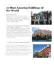
10 Most Amazing Buildings of the World The Crooked House Though it looks like some sort of painting by a drunk painter. But this is a real house located in Rezydent Shopping Center in Sopot, Poland. It is claimed to be the most photographed building in Poland. It is spread to an area of 4,000 square meters. Designed by Architect: Szotynscy Zaleski 2. Forest Spiral - Hundertwasser Building Architect: Heinz M. Springmann This is a residential building complex located in Darmstadt, Germany. The building has a unique façade which doesn’t follow a regular grid pattern and the windows appear as if they are dancing out of line and appear out of order. It was designed by Viennese artist Friedensreich Hundertwasser and finally planned and implemented by architect Heinz M. Springmann. It contains 105 apartments, an inner courtyard, a small artificial lake and also a playground for children. The building has 12 floors. 3. The Torre Galatea Figueras (Spain)
London History The Romans AD 43- AD 410 The Romans finally invaded Britain in AD 43 from Kent. The Romans lead by Julius Caesar attempted to invade Britain twice before that in 55 and 54 BC but the invasions were unsuccessful. They made their way to the river Thames and sailed up it. The Romans knew it was important to control a crossing point at the river Thames, so they decided to build a settlement on the north bank. Although small settlements had been built on the banks of the Thames, the Romans were the ones who built the first city. They called their city Londinium. The Roman engineers noticed that the point where the swampy river narrowed would make an ideal crossing point, they built London Bridge. Less than 20 years later the native Iceni tribe, led by Queen Boudicca, rose up against the Romans in revenge for mistreatment and burnt
The Danes, led by King Valdemar II, conquered northern Estonia in 1219. Legend has it that one day, when the Danes were about to lose a bloody battle, the sky suddenly opened and a red flag with a white cross on it dropped down upon them from the heavens. This is allegedly how the Danes obtained their national flag, the Dannebrog in a battle against the Estonians. In the middle of the 14th century Denmark sold its possessions in Estonia to the German Teutonic Order. Toompea became the seat of the German-born gentry. A wall was built to separate the Upper Town and the Lower Town. In 1285 Tallinn joined the Hanseatic league and became a junction of trade between East and West. Tallinn is said to be built on salt, as it was an important trading commodity. In the 16th century Tallinn had a population of about 7,000 8,000 making it one of the biggest cities in northern Europe. In 1629 Sweden took control of the whole of Estonia. Though hard times
London important sights guide Roman period 20th century · Big Ben is the nickname for the great bell of the clock at the north end of the Palace of Westminster in London and is often extended to refer to the clock or the clock tower as well. It is the largest four-faced chiming clock and the third-tallest free-standing clock tower in the world. The clock first ticked on 31 May 1859. The pendulum is installed within an enclosed windproof box sunk beneath the clockroom. It is 3.9m long, weighs 300 kg and beats every 2 seconds. The clockwork mechanism in a room below weighs 5 tons. · Buckingham Palace is the official London residence of the British monarch. Originally known as,
Tallinn English College Topic Estonia Tallinn 2008 1. Introduction Estonia is a small country about the size of Switzerland, or New Hampshire and Massachussetts combined. Estonia is named after the people called "Ests" who lived in the region in the 1 st century AD. The Republic of Estonia is one of the three countries commonly known as the "Baltic States". The other Baltic States are Latvia and Lithuania. 2. Geographical position Estonia is situated in northeastern Europe. Estonia is bounded on the north by the Gulf of Finland, on the east by Russia, on the south by Latvia and on the west by the Baltic Sea. In the north it borders on Finland. The coastline of the Baltic Sea in Estonia is characterized by numerous gulfs and bays, the biggest of them
the wife of Kalev and mother of Kalevipoeg Koluvan - mentioned in Russian chronicles; derives from the hero Kalev from our national epic Reval - comes from the German words “REH” and “FALL”, meaning the falling of the deer; could be deers trying to escape from the Danes, running down the Toompea hill Tallinn - the word origins from estonian language, could mean “taani-linn”, “tali-linn” or “talu- linn”; Reval was replaced when Estonia became independent Symbols Flag - blue black white tricolor; blue represents sky, black the soil, and white our freedom. Danneborg - red flag with a white cross fell from the sky during the battle in 1219. It is also set into the small coat of arms of Tallinn. Great coat of arms - three lions, a knight, and Danish queen; leaves around Old Thomas - quardian of Tallinn, put on top of the spire of Tallinn Town Hall in 1530;
I. Portugal ABOUT Photo Location of Portugal (dark green) Portugal (Portuguese: Portugal, IPA: [putua]; officially the Portuguese Republic, Portuguese: República Portuguesa) is a country located in Southwestern Europe, on the Iberian Peninsula. It is the westernmost country of mainland Europe, and is bordered by the Atlantic Ocean to the west and south and by Spain to the north and east. The Atlantic archipelagos of the Azores and Madeira are
The area today lies in the very heart of the historical Mulgimaa the home of hills, deep valleys and lakes brought together by a beauty spot Halliste primeval valley. According to several folk tales, it is also in these valleys, woods and bogs that Old Nick found refuge.The great variety displayed in the nature is also reflected in the local cultural heritage. At the beginning of the 19th century growing linen spread and became the basis of the legendary wealth of Mulgi farms. The ancient barn-dwellings and decaying manor houses are the mute witnesses of those times. The riches and cultural heritage of Mulgimaa owe to the diligence and tenacity of the local people. Village handicraftsmen and masters have always been honoured. Mulgikapsad (stewed sauerkraut with barley groats), Estonian cheesecakes and kama (a roasted meal-mixture) have not lost their popularity.
the north of Estonia in 1219. Legend has it that one day, when the Danes were about to lose a bloody battle, the sky suddenly opened and a red flag with a white cross on it dropped down upon them from the heaven. This is how the Danes obtained their national flag. In 1346 the Danish king sold his Estonian lands to the Teutonic Order, who a year later resold them to the Livonian Order. The Germans renamed Tallinn and called it Reval. Toompea became the seat of the German-born gentry. A fortified wall was built between Toompea (the Upper Town) and the Lower Town, as there were conflicts between the two. The Lower Town was the home of simple people, the artisans and the merchants. The doors and gates in the wall were locked at night. Tallinn joined the German-dominated Hanseatic League in 1285 and became a junction of trade between East and West: furs, honey, leather and seal fat moved west, while salt, cloth, herring and wine moved east
the British Museum. But if you miss, such as the cable have more time, hit up Portobello cars, Fisherman's Road and Borough Market to Wharf andAlcatraz. And, of appreciate the local culture. course, the city's crowning architectural achievement, the Golden Gate Bridge, is unmistakable. New York City and Maui Why go: Author Ayn Rand once Why go: Of all the Hawaiian Islands, wrote, "I would give the greatest Maui might be the most beloved. The sunset in the world for one sight of island encapsulates all that Hawaii has New York's skyline." While many to offer: exotic beaches (like disagree with her politics, her Kaihalulu), palatial resorts (like
The history of the Netherlands 2.1 1st dated historical facts Historical accounts of the Netherlands date from the 1st century BC, when Roman forces led by Julius Caesar conquered most of the present area of the country. At the time the region was inhabited by Frisians, a Germanic tribe that lived in the north, and by other Germanic and minor Celtic tribes. (3) 2.2 The Roman Era Before the conquest, the Romans had annexed lands to the southeast extending beyond the Rhine River. They penetrated the Netherlands region mainly to control the several mouths of the Rhine, which were then farther to the north than they are now. Under Roman rule, general peace and prosperity prevailed for more than 250 years. Roman traders entered the area freely, selling products from Italy and Gaul. The Romans built temples, established a number of large farms, and introduced their civilization to the region.
The UK & London The United Kingdom (or the UK) is a short way of saying the United Kingdom of Great Britain and Norther Ireland. The UK is situated north-west of the European continent between the Atlantic Ocean and the North Sea. The UK consists of England, Wales, Scotland and Northern Ireland. Its highest point is Ben Nevis in Scotland followed by Snowdon in Wales. The Severn is the longest river in the United Kingdom. Other important rivers are the Trent, the Mersey, the Tyne, etc. Lough Neagh which lies in the centre of Northern Ireland is thr UK's largest freshwater lake. The climate in the UK is variable. The weather changes so frequently that it is difficult to forecast. It is not unusual for people to complain that the weathermen were wrong. Fortunately there is no extreme weather conditions, it is never very cold or very hot.
7 million square miles (over 9.6 million km²) and population more than 300 million people. The capital city is Washington D.C. Although the United States has no official language at the federal level, English is the de facto national language. English is the most common language for daily interaction among both native and non-native speakers. Spanish is the second language. The largest city is the New York City. The Government is Federal constitutional republic and the president is George W. Bush. 2. Geographical position The United States of America is located on the continent of North America. It has borders with two countries Mexico and Canada. There are also the Atlantic Ocean, the Pacific Ocean and the Gulf of Mexico surrounding the big country. There are 50 states in America. Most of the people live in towns. The biggest state is Alaska; next by size are California, Alaska and Montana
In the 13 th- century chronicle of Henricus de Lettis the town was called Lyndanise. Then it was called Reval for some time and finally Estonians started to call the town Tallinn from Taanilinn (Danish town) after the Danish conquest in the 13th century. The Knights of the Sword took Tallinn from the Danes in 1227 and made Toompea their fortress. In the middle of the 14th century Denmark sold its possessions in Estonia to the German Teutonic Order; Toompea became the seat of German-born gentry. A fortified wall was built between the Toompea (the Upper Town) and the Lower Town (inhabited by people of a lower social standing), as there were conflicts between the two. The doors and the gates of the wall were locked at night, a procedure which carried on until the end of the 19th century. Tallinn joined the German-dominated Hanseatic League in 1285 and became a junction of trade between East and West: furs, honey, leather and seal fat moved west,
Ireland is the third largest island in Europe. It lies in between the Atlantic Ocean and the Irish Sea. Politically it is divided into a sovereign state, the Republic of Ireland, that covers about five-sixths of the island (south, east, west and north-west), and Northern Ireland, which is part of the United Kingdom, covering the northeastern sixth of the island.[1] The name 'Ireland' derives from the name Ériu (in modern Irish, Éire) with the addition of the Germanic word 'land'. The population of the island is just under 6 million (2006); just over 4.2 million in the Republic of Ireland[2] (1.6 million in Greater Dublin[3]) and just over 1
Estonia Estonia, officially the Republic of Estonia, is a state in the Baltic region of Northern Europe. It is bordered to the north by the Gulf of Finland, to the west by the Baltic Sea, to the south by Latvia, and to the east by Lake Peipus and Russia. Across the Baltic Sea lies Sweden in the west and Finland in the north. The territory of Estonia covers 45,227 km 2, and is influenced by a humid continental climate. The Estonians are a Finnic people, and the official language, Estonian, is a Finno-Ugric language closely
displayed in the Museum of London in the Barbican. At the end of the fourth century AD the Roman Empire began to crumble and the Roman armies were recalled from Britain to defend Rome itself. Once they had left Anglo-Saxons invaded and settled in Britain. They were farming people who preffered to live outside towns. For a while London probably lay in ruins, but it eventually developed again, partly because of its position on the river was good for trading. The Tower of London There is more of London's history in the Tower than anywhere else in London. It is the oldest surviving building in the capital. The Tower of London was begun by William the Conqueror in 1078 as a castle and a palace but even before the site had been used by the Romans and Anglo-Saxons. The tower comprises not one, but 20 towers, the oldest, the White Tower, dates back to the 11 th Century.
the sixth largest nation, its territory is 7,686,850 sq km and its population reaches today over 20,5 million people. It is the only nation to govern an entire continent and its outlying islands. Australia's capital is Canberra, the only city with its own territory. It was built in the early 1900s just to be the capital. The official language is English and the official name of Australia is the Commonwealth of Australia. Australia is located on the Southern Hemisphere (because of that Australia is also called "A land down under"). 2 . Geographical position Australia is an island continent and it is located between the Indian and South Pacific oceans south east of Asia. From the north it is bordered by the Timor Sea and the Torres Strait. From the east by the Coral Sea and the Tasman Sea. Australia's coastline is about 37,000 km long. The Great Australian Bight washes the southern coast
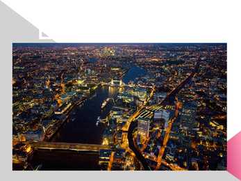
grown up around it. London has been an important settlement for over two millenniums. It is also one of the world's leading business, financial and cultural centres and its influence in politics, education, entertainment and even fashion contribute to its status as a major global city. London is a major tourist attraction with four world heritage sites, several royal parks and numerous iconic landmarks such as the Houses of Parliament, Towe Bridge, the Tower of London, Westminster Abbey and the London Eye. 2. History Although there is some evidence of a permanent settlement before the Romans came in 43 A.D., it is more accepted by historians that the Romans were the first. The settlement was called Londinium. The first London lasted for just seventeen years, for around AD 61, a tribe of Celts led by Queen Boudica stormed London, burning it to the ground. The next heavily-planned London
Waltham Forest 12. Brent 29.Haringey 13. Ealing 30.Enfield 14. Hounslow 31.Barnet 15. Richmond 32.Harrow 16. Kingston 33.Hillingdon 17. Merton Details of London London is the capital city of England and the United Kingdom Located on the River Thames Romans called it Londinium Since at least the 19th century has this town called London The mayor of London is Boris Johnsonc, since 4 May 2008 London is a leading global city And also London has been described as a world cultural capital London has the third most international visitors in the world London's 43 universities form the largest concentration of higher education in Europe More than 300 languages are spoken within its boundaries
.......................3 London's early history.....................................45 The people of London......................................6 Buildings and bridges......................................7 Intruduction London is the capital of the united kingdom (UK), which is made up of Great Britain(England, Scotland, Wales) and Northern Ireland. The city lies in the southeast of England and covers an area of about 1,578 square kilometres on either side of the River Thames. With population of seven million, London is by far the largest city in the UK. Birmingham, the second largest, has just over one million inhabitants. Cultural life London is the worldclass centre. It has more than40 theatres, where audiences enjoy everything from musicals to William Shakespeare's plays. The city also contain many cinemas, concert halls, museums and art galleries. Royal residence
Tallinna Inglise Kolledz Estonia Topic Alice Tärk, 9b Tallinn 2007 FACTFILE Area: 45 228 sq km Poplulation: under 1.4 million Capital: Tallinn Language: Estonian Currency: Eesti kroon (EEK) Main religion: Lutheran National holiday: 24 February (anniversary of the republic) National flower: Cornflower National bird: Barn Swallow National stone: Limestone LOCATION The Republic of Estonia is the northernmost and smallest of the three Baltic States. It is located on the eastern shores of the Baltic Sea in the north east of Europe. To the east the country borders Russia. Latvia is the countries neighbour to the south. From the west the coast of Estonia is washed by the Baltic Sea and from the north by the Gulf of Finland. The length of the coastline is approximately 3 800 km. The longest distance from east to west is
Petersburg, and was an academician at the St. Petersburg Academy of Sciences.Seven geographical objects worldwide have been named in his honour. A ritual for university students is washing the hair of the Baer statue head on the eve of St. Philip's Day. Kristjan Jaak Peterson monument Kristjan Jaak Peterson was an Estonian poet, author of odes and pastorales, who was born in Riga and studied in Tartu. The aim of his work became the creation of literature in the original Estonian language. The Kissing Students The sculpture and fountain "The Kissing Students" located at the Tartu Town Hall Square, has become a symbol of Tartu. Erected in 1998, it was conceived by Mati Karmin. Legend kõneleb suudlevate tudengite kohta järgmist:Ühel hämaral sügisõhtul jalutas armunud tudengipaar mööda Tartu südalinna. Suudeldes ja naerdes jõudsid nad Raekoja platsile. Äkki
Musical shows, dances and contests of strength and skill will be held all over town. This festival is held in August and it is said that Haapsalu, Estonia's most famous ghost, appears during this festival Black nights film festival http://www.tourism.tallinn.ee/fpage/events/newwinprint/ Beerfestival ( Õllesummer) The beer festival "Õllesummer" is one of the largest festivals in the region--bringing together 80,000 people each year. Õllesummer is located in the Tallinn Song Festival grounds which is located 15 minutes walking time from the center of the city. The program includes Estonian bands and international acts as well featuring over a 100 concerts on more than 10 stages. Õllesummer is a friendly, safe and joyful event that attracts many tourists and visitors of Tallinn. Next Õllesummer festival will take place between 8-12 July 2009 in Tallinn Song Festival
London. All of them were at one time independent kingdoms with their own monarch. Now they are all part of the same kingdom and share the same monarch. The UK consists of Northern Ireland, Scotland, England and Wales. The peoples of these countries are British subjects; they hold British passports and therefore their nationality is British. The british Isles is the geographical name for all the islands off the west coast of Europe. These islands also include The Republic of Ireland, which is politically independent of the Britsh government. Many people refer to the inhabitants of the British isles as 'the English', but England is only one of the countries. The other countries are Scotland, Wales and Northern Ireland. Great britan is the name of the one island which is made up of Scotland, England and Wales. It is calles Great because in some languages the word for Britain is the same as the word for Brittany, which is in France
Technical English, Scientific English, English for medical professionals, English for waiters, English for tourism, English for Art Purposes, etc 4. What is the difference between settlement colonies and the trading empire (dependencies)? Settlement colonies were regions colonized by the UK that later established governments and became dominions and independent. Dependencies were regions in the world that became trading partners and where English became a second language. 5. Which British colonies became dominions? What was their status? Is the name dominion used for these countries nowadays? The first dominions were Canada (1867), Australia (1901), and New Zealand (1907) The name "dominion" is not used anymore. 6. Which organisation unites Britain and most of its former colonies nowadays? The Commonwealth unites Britain with its former colonies. Ireland 1. Who were the early inhabitants of Ireland?
Its characteristic features are mild winters, warm summer, no temperature extremes, abundant rain all year round and frequent changes of weather. The mild climate is partly due to the warm Gulf Stream and partly to the south westerly winds. Occasional winds from the east in winter may bring cold and dry weather. The distribution of rainfall is influenced by the Atlantic Stream. The mountainous areas of the north and west have more rain than the lowlands of the south and east. Wales is located on a peninsula in central-west Britain. The entire area of Wales is about 20,779 km². Wales borders by England to the east and by sea in the other three directions: the Welsh Channel to the south, St George's Channel to the west, and the Irish Sea to the north. There are many bays, peninsulas, cliffs and beaches, together Wales has almost 2000 km of coastline. There are several islands off the Welsh mainland, the largest being Anglesey in the northwest.
They lived in primitive society. Druids priests, more powerful than chiefs. Acted like prophets. 2. Stonehenge From prehistoric period. Was built on Salisbury plain between 2500 and 1500 bc. One of the most famous and mysterious archaeological sites in the world. One of the mysteries is how it was built at all with the technology of the time. Another is its purpose. It appears to function as a kind on astronomical clock and we know it was used by the Druids for ceremonies marking the passing of the seasons. It appears in number of novels. These days it is not only the interest of tourists but is also a gathering point of certain minority groups. It is now fenced off to protect it from damage. 3. The Roman conquest Julius Caesar's first raid was in 55 BC but the romans left. Ad 43- the Romans came to stay. The army established Roman rule in the south and SW of the country
Estonia Topic Tallinn 2007 2 List of Contents page Facts and figures 3 Geography 3 Climate 3 Nature 4 History 5 Economy 6 Culture 6 Biggest towns 7 Language 8 3 Facts and figures The Republic of Estonia is a small country. Covering only 45, 228 sq km it is slightly bigger than Denmark, Belgium or Switzerland. Estonia's population is under 1.4 million. The official language is Estonian but since very many Russians live here Russian is also wide spread. The capital of Estonia is Tallinn. The currency used in Estonia is Eesti kroon. The Estonian national flag is blue-black-white. It was originally the flag of the Estonian Students' Society
● Tallinn - used after Estonia gained its independence in 1918, origin is definitely estonian; meaning Taani-linn, tali- linn. Liberty Square ● The central square of Tallinn, it was renovated in 2008. There used to be Harju gate, which can now be seen through glass. ● The statue of Liberty, 2009; represents freedom, Estonia has been under many foreign powers, starting with Danes, Sweden, German and Russia. The clock of liberty, 2004. Kiek in de Kök ● The cannon tower, founded in 1475-1483. Kiika kööki, peek into the kitchen, from up there it was possible to peek into the enemy’s kitchen. The walls are 4 m thick, can see the cannons stuck in there. Tallinn City Museum. ● Town Wall (Unesco) - one of the greatest towers of Tallinn’s Town Wall, Old Town declared the UNESCO World Heritage Site in 1997 Toompea ● Toompea is a limestone hill in the central of Tallinn
Foreword Bridging rivers, gorges, narrows, straits, and valleys always has played an important role in the history of human settlement. Since ancient times, bridges have been the most visible testimony of the noble craft of engineers. A bridge can be defined in many ways, but Andrea Palladio, the great 16th century Italian architect and engineer, hit on the essence of bridge building when he said "...bridges should befit the spirit of the community by exhibiting commodiousness, firmness, and delight." In more practical terms, he went on to explain that the way to avoid having the bridge carried away by the violence of water was to make the bridge without fixing any posts in the water. Since the beginning of time, the goal of bridge builders has been to create as wide a span as possible which is commodious, firm, and occasionally delightful