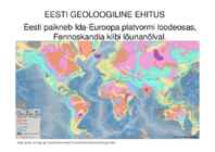
EESTI GEOLOOGILINE EHITUS Eesti paikneb Ida-Euroopa platvormi loodeosas, Fennoskandia kilbi lõunanõlval. http://quake.wr.usgs.gov/research/structure/CrustalStructure/database/type.html Arold, I., 2005. Eesti maastikud. Arold, I., 2005. Eesti maastikud. Arold, I., 2005. Eesti maastikud. Raukas, A., Teedumäe, A. (eds). 1997. Geology and Mineral Resources of Estonia. Estonian Academy Publishers, Tallinn. 436 pp. Photo 13. The historically known Aruküla caves near Tartu where since 1831 large placoderms and other Devonian fishes have been excavated. Photo by Ü. Heinsalu and E. Mark-Kurik. Holotseen - turvas, jõe-, järve- ja meresetted, samuti luiteliivad jne Kvaternaar purdsetted
Marko Pomerants Marko Pomerants was born in 24.09.1964,in Tamsalu,in West-Virumaa. Personal status: Married,two sons Estonian Military monumental- medal "10 years of recovered military " 2001 Border Guard badge "Sword and Lynx" 2002 Lifesaving service goldencros s 2002 Border Guard favourcros s II class 2000 Tamsalu Secondary School 1982 Tartu University, Geology 1989; open management degree 2002 Party:Isamaa and Res Publica Union 2002 Room L 149 Jobs: Parliament 2007 Parliament 20052007; Minister of Social Affairs of Estonia 2003-2005 West-Viru county governor 19952003 West-Viru county goverment elementchapter's leader Funniest speaking. Estonian Parliament's member Marko Pomerants (IRl) performs preposal that in case of republic's jubileeyear should estonians take down 900 000kg together. Creational Activity: articles in Estonian
Eesti aluspõhi Mandrite triiv · http://www.ucmp.berkeley.edu/geology/tectoni · http://student.britannica.com/eb/art- 57799/The-changing-Earth-through- geologic-time-from-the-late-Cambrian · http://www.exploratorium.edu/origins/antar ctica/ideas/gondwana2.html · http://www.scotese.com/newpage13.htm Platvorm · Platvorm on suur maakoore osa, mis koosneb kurrutatud kristalsete kivimitega aluskorrast ning seda katvast, kurrutamata kivimitega pealiskorrast. · Pealiskorra pindmist, pudedatest setetest osa nimetatakse pinnakatteks.
the state of New York. Niagara Falls · From largest to smallest, the three waterfalls are the Horseshoe Falls, the American Falls and the Bridal Veil Falls. The Horseshoe Falls lie mostly on the Canadian side and the American Falls entirely on the American side, separated by Goat Island. The smaller Bridal Veil Falls are also located on the American side, separated from the other waterfalls by Luna Island. Geology · About 10,900 years ago, the Niagara Falls was located between present-day Queenston, Ontario, and Lewiston, New York, but erosion of their crest has caused the waterfalls to retreat approximately 6.8 miles (10.9 km) southward. The Horseshoe Falls, which are approximately 2,600 feet (790 m) wide, have also changed their shape through the process of erosion; evolving from a small arch, to a horseshoe bend, to the present day gigantic inverted V.
Strange and mysticals places on Earth Eye of africa - Mauritania Eye of africa- Mauritania · The Richat structure (Sahara, Mauritania) appears as a large dome at least 40 km in diameter within a Late Proterozoic to Or- dovician sequence. · This natural phenomenon is actually a Richat structure caused by the dome shaped symmetrical uplifting of underlying geology now made visible by millennia of erosion. Socotra island · is a small archipelago of four islands in the India Ocean. The largest island, also called Socotra, is about 95% of the landmass of the archipelago. It lies some 240 kilometres (150 mi) east of the Horn of Africa and 380 kilometres (240 mi) south of the Arabian Peninsula. The island is very isolated and through the process of speciation, a third of its plant life is found nowhere else on the planet.
It has not been proven yet, so people are scared and concerned about it. The biggest fear is that carbon dioxide will leak out but we don't have to be worried about that, because CO2 is everywhere around us and it is not poisonous. But still, if we have very concentrated carbon dioxide, it is hazardous and that's purpose of monitoring. Rick Russell sees no definite risk associated with the release or damage either to the surface, soils or ground water, because the type of geology they are useing, will protect the planet from this happening. For now, they have given investment sanction to two projects one in Norway in partnership with thw government there and with Statoil, and the anaother one in Australia. Prof. Martin Blunt is sure that if they cannot get Carbon capture and storage to work, then the world will be committed to dangerous climate change. But we cannot leave it on scientists' shoulders and we should help ourselves too by living greener.
koostisega, nende kantserogeensuse hindamine võrreldes puhaste ainetega. Toksikoloogilised ja epidemoloogilised laboratoorsed uurimused. OTSING RCS Journals - sisaldab keemia ja loodusteaduste artikleid groundwater AND health AND problems AND carcinogens OR cancer OR carcinoma 32122 vastet, neist 17723 artiklit Mitchell E.; Frisbie S.; Sarkar B. (2011). Exposure to multiple metals from groundwater—a global crisis: Geology, climate change, health effects, testing, and mitigation. - Metallomics., 9, 874-908. [Online] doi: 10.1039/C1MT00052G (11.04.2013) Põhjavees loomulikult eksisteerivate toksiliste metallide levimus. Nende keemilised, biokeemilised ja füsioloogilised interaktsioonid. Analüütilised katsemeetodid proovide jaoks, mis sisaldavad mitut metalli. OTSING Scopus – andis pealkirjast saadud märksõnadega spetsiifilisemad tulemused, kui muude märksõnadega
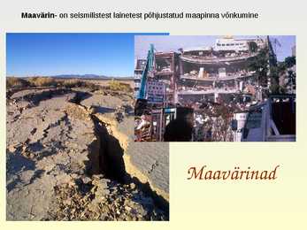
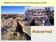
Maavärin- on seismilistest lainetest põhjustatud maapinna võnkumine Maavärinad Maigi Astok Maavärina tekkepõhjused · Laamade erisuunaline liikumine, tekivad maakoore sisepinged · Vulkaanipursked · Koobaste varisemine · Inimtekkelised e tehnogeensed (veehoidlate surve, lõhkamistööd, tuumakatsetused) http://idahoptv.org/dialogue4kids/season11/geology/resources.cfm Mis on maavärin? Maavärin on maapinna vibratsioon ja nihked, mis tekivad kivimites kuhjunud elastsete pingete lahendumise protsessis koos kivimite rabenemisega. · maavärina kolle (fookus) on koht maapõues, kust algab kivimite rebestumine maavärina murrang. · maavärina kese (epitsenter) on vahetult kolde kohal olev koht maapinnal Maavärinate esinemispiirkonnad Punasega on tähistatud vulkaanide levikualad, kollasega
Maavärin- on seismilistest lainetest põhjustatud maapinna võnkumine Maavärinad Maigi Astok Maavärina tekkepõhjused • Laamade erisuunaline liikumine, tekivad maakoore sisepinged • Vulkaanipursked • Koobaste varisemine • Inimtekkelised e tehnogeensed (veehoidlate surve, lõhkamistööd, tuumakatsetused) http://idahoptv.org/dialogue4kids/season11/geology/resources.cfm Mis on maavärin? Maavärin on maapinna vibratsioon ja nihked, mis tekivad kivimites kuhjunud elastsete pingete lahendumise protsessis koos kivimite rabenemisega. • maavärina kolle (fookus) on koht maapõues, kust algab kivimite rebestumine – maavärina murrang. • maavärina kese (epitsenter) on vahetult kolde kohal olev koht maapinnal Maavärinate esinemispiirkonnad Punasega on tähistatud vulkaanide levikualad, kollasega
political centre of the country. An abundance of natural resources such as coal, iron and zinc contributed significantly to the industrial growth of Scotland during the 19th and early 20th centuries. Today, energy is a major component of Scotland's economy. Whilst Scotland is the largest producer of petroleum in the European Union, the production potential of renewable energy has emerged as an important economic and environmental issue in recent years. Geology and geomorphology ! The geology of Scotland is unusually varied for a country of its size, with a large number of differing geological features. There are three main geographical subdivisions: the Highlands and Islands is a diverse area which lies to the north and west of the Highland Boundary Fault; the Central Lowlands is a rift valley mainly comprising Paleozoic formations; and the Southern Uplands, which lie south of a second fault line, are largely composed of Silurian deposits.
Lake Võrtsjärv Scientific editors Juta Haberman Ervin Pihu Anto Raukas Liis Sommer The outline Rural municipalities River geology Shores Flows Temperature Planktonic algae Fishes Animals Lake Võrtsjärv is a lake in southern Estonia with an area of 270 km² . It is the second largest lake of Estonia. The shallow lake is 33.7 m above sea level. The river Emajõgi flows from Lake Võrtsjärv to Lake Peipsi. Lake Võrtsjärv area comprises seven rural municipalities bordering the water,
3. kvaternaarsete jäätumiste ning Läänemere veepinna kõikumiste tähtis osa pinnamoe kujunemisel; 4. paras-jahe niiske merelise ilmega kliima; 5. järvede, jõgede ja soode rohkus (positiivse veebilansiga ala); 6. segametsade vööndile omane mullastik, taimestik ja taimkate, samuti loomastik (flooras ja faunas esineb võrdlemisi palju lääne päritoluga liike); 7. inimtegevuse oluline mõju nüüdismaastike kujunemisel. Raukas, A., Teedumäe, A. (eds). 1997. Geology and Mineral Resources of Estonia. Estonian Academy Publishers, Tallinn. 436 pp. Photo 62. Lammasmägi Hill near Kunda. About 8500 years ago its surroundings were inhabited by hunters and fishers who lived in small clan communities and gave a name to the well-known Mesolithic Kunda Culture. Photo by G. Baranov. Inimese loodusesse sekkumise olulisemad algusajad (Arold, jt 1987 järgi)
O'odham name al onak, meaning "small spring", which initially applied only to an area near the Mexican silver mining camp of Planchas de Plata, Sonora. This is supported by the fact that the area is still known as al onak in the O'odham language. Another possible origin is the Basque phrase haritz ona ("the good oak").There is a misconception that the state's name originated from the Spanish term for "Arid Zone". Geography and geology Arizona is located in the Southwestern United States as one of the Four Corners states. Arizona is the sixth largest state by area, after New Mexico and before Nevada. Of the state's 113,998 square miles (295,000 km2), approximately 15% is privately owned. The remaining area is public forest and park land, state trust land and Native American reservations. Arizona is well known for its desert Basin qnd range region in the southern portions of the state,
2009. Imeline maa : entsüklopeedia : geoloogiline areng, hiidmandrid, kliima, pinnavormid, loomad, taimed. Koolibri, Tallinn, 576 lk. 3. Gornitz, V. 2009. Encyclopedia of paleoclimatology and ancient environments. Springer, Dordrecht, 1047 lk. [Inglise keeles] 4. Kuzina, S. 2013. 10 kõige uskumatumat hüpoteesi sellest, et miks dinosaurused kadusid. http://www.kp.ru/daily/26123.4/3015794/ [Vene keeles] 06.12.2014 5. Monroe, J. S. & Wicander, R. 2004. Historical Geology. Thomson Learning, Belmont, 427 lk. [Inglise keeles] 6. Plummer, C. C., Carlson, D. H., Hammersley, L. 2013. Physical geology. McGraw-Hill, New York, 642 lk. [Inglise keeles] 7. Sepp, S. 2010. Dinosaurustele tegi lõpu ikkagi asteroid. http://novaator.ee/ET/loodus/dinosaurustele_tegi_lopu_ikkagi_asteroid/ 08.12.2014 8. Tselikov, D. 2012. Dinisaurused olid väljasuremas jaba enne meteoriidi kukkumist. http://science.compulenta
Geological Society London Special Publications 101 (1): 401. Thomas, D. J. & Bralower, T. J. 2005 Sedimentary trace element constraints on the role of North Atlantic Igneous Province volcanism in late Paleoceneearly Eocene environmental change. Mar. Geol. 217, 233254. Rodríguez-Tovar F.J., Uchman A., Alegret L., Molina E., 2011. Impact of the PaleoceneEocene Thermal Maximum on the macrobenthic community: Ichnological record from the Zumaia section, northern Spain. Marine geology 282, 178-187. Zachos, J. C.; Kump, L. R. (2005). "Carbon cycle feedbacks and the initiation of Antarctic glaciation in the earliest Oligocene". Global and Planetary Change 47 (1): 5166. Zachos, J.C.; Dickens, G.R.; Zeebe, R.E. (2008). "An early Cenozoic perspective on greenhouse warming and carbon-cycle dynamics" (PDF).Nature (journal) 451 (7176): 27983. Winguth A.M.E., 2011.The Paleocene-Eocene Thermal Maximum: Feedbacks Between Climate Change and Biogeochemical Cycles
Grasslands: Calcification is the dominant soil-forming process in semiarid regions. When this process works on a loess that itself is rich in calcium, the world's most fertile soils are created, the chernozems (A Russian term meaning black soil). Taiga: The low temperatures inhibit bacterial and fungal action, so the decomposition rate is low and the leaf litter relatively deep.The soil in the taiga is thin, acidic and not very nutrient rich. It also is rocky. 6. What is permafrost? In geology, permafrost, cryotic soil or permafrost soil is soil at or below the freezing point of water (0 °C or 32 °F) for two or more years. Ice is not always present, as may be in the case of nonporous bedrock, but it frequently occurs and it may be in amounts exceeding the potential hydraulic saturation of the ground material. 7. What is gully? A gully is a landform created by running water, eroding sharply into soil, typically on a hillside. Gullies resemble large ditches or small
ühte iseloomustavad teatud kindlad põhi liigid. Inimasustus on väga hõre või puudub üldse. KASUTATUD KIRJANDUS Eklund, O., Soesoo, A. 2007. Kristalsed kivimid Lõuna-Soomes ja Eestis. [WWW] http://www.gi.ee/geoturism/Bedrock%20SW%20Finland_EST_062011_100dpiS.pdf (30.11.2013) Maailma Loodusvööndid. [WWW] http://www.geo.ut.ee/kooligeo/loodus/home.htm (30.11.2013) Northern Norway. 2013.[WWW] http://en.wikipedia.org/wiki/Northern_Norway (30.11.2013) Per Andersson, E. 2009. Geology of Fennoscandia. [WWW] http://www.nrm.se/english/researchandcollections/researchdivision/laboratoryforisotopegeolo gy/moreaboutisotopegeology/geologyoffennoscandia.291_en.html (30.11.2013) Ratcliffe, D.A.2006. Lapland: A Natural History. Yale University Press, China Suur Maailma Atlas.2005. Eesti Entsüklopeediakirjatus, Läti The Tana river of Lapland is the best salmon river in Europe. [WWW] http://www.lapland- travel-info.com/Tana-river.html Tundra. 2013. [WWW] http://en.wikipedia
United Kingdom; the island groups Orkney and Shetland, which were acquired from Norway in 1472; and Berwick-upon-Tweed, lost to England in 1482. The geographical centre of Scotland lies a few miles from the village of Newtonmore in Badenoch. Rising to 1,344 metres (4,406 ft) above sea level, Scotland's highest point is the summit of Ben Nevis, in Lochaber, while Scotland's longest river, the River Tay, flows for a distance of 190 km (120 miles). Geology and geomorphology The whole of Scotland was covered by ice sheets during the Pleistocene ice ages and the landscape is much affected by glaciation. From a geological perspective the country has three main sub-divisions. The The climate of Scotland is temperate and oceanic, and tends to be very changeable. It is warmed by the Gulf Stream from the Atlantic, and as such has much milder winters (but cooler, wetter summers) than areas on
keemilisi aineid, näiteks H2, H2S, Fe-sulfiidi, metaani jne. On arvatud, et elu võis Maal tekkida ka sellistes tingimustes. Mikroobid on elanud mustade suitsetajate kooslustes juba vähemalt 3.3 miljardit aastat. Westall, F. et al. (2015) Archean (3.33 Ga) microbe-sediment systems were diverse and flourished in a hydrothermal context. Geology 43, 615–618 http://www.youtube.com/watch?v=rFHtVRKoaUM Mikrobioloogia I 2017
Elken, J. 2009. Merehoovuste trikid. - Horisont, nr 1. http://www.horisont.ee/node/846 Hieb, M. 2009. Climate and the Carboniferous Period. http://www.geocraft.com/WVFossils/Carboniferous_climat e.html Illarionov, A. 2004. The Kyoto Protocol: an Assault on Science, Economic Growth, and Human Freedoms. http://www.iea.ru/article/kioto_order/kyoto.ppt Jutras, P. 2007. Alarmist Global Warming Models vs the Geological Record. http://www.smu.ca/academic/science/geology/bios/documen ts/ALARMISTGLOBALWARMINGMODELSVSTHEGE OLOGICALRECORDHongKong2007.pdf Kallaste, T. 2001. Eesti kui ÜRO kliimamuutuste raamkonventsiooni liikmesriik. SEI. Tallinn. Labitzke, K. 1987. Sunspots, the QBO, and the stratospheric temperature in the North Polar region. Geophysical Research Letters, 14, 535. McKitrick, R.R., Michaels, P.J. 2007. Quantifying the influence of anthropogenic surface processes and inhomogeneities on gridded global climate data
Lithuanian depression, sandy-silty sediments Agueooni (Proterosoikumi) lõpul hakkas Rodinia vajub või ookeanipõhi kerkib, kui ka leidub haliiti, oli kunagi meri/laguun/soolajärv deposited”- http://sarv.gi.ee/geology/ ülimanner järk-järgult väiksemateks osadeks eksogeensed protsessid (mandrijää sulamine (veekogu), mis taandus ja ala jäi kuivaks. See on vara-devon, Lochkovian age. Silt on lagunema. Üks neist osadest on saanud midagi liiva ja savi vahepealset. jäävaheajal, olulised kliima muutused), mille tänaseks nime Baltika kraaton
(2007) http://www.aripaev.ee/article/20071026/NEWS/310269931 01.12.2016 9. G. Ilves.(2005) Katastroofid, sündmused, faktid: St. Helens. 45-47. 10. Forte. Mount St. Helens - vulkaan, mis tahab vist jälle purskama hakata(2014) http://forte.delfi.ee/news/maa/mount-st-helens-vulkaan-mis-tahab-vist-jalle- purskama-hakata?id=68608621 01.12.2016 11. G. Ilves.(2005) Katastroofid, sündmused, faktid: Nevado del Ruiz. 48-49 12. R. C. Selley, L. R. M. Cocks, I. R. Plimer (2005). Encyclopedia of Geology: Vulcanoes. 5:565–579 13. H. Rast. (1988) Vulkaanid ja vulkanism. 218-221.
(varvide) loendamisel saab määrata lasundi kuhjumise aega ja mandrijää taandumise kiirust. Ülimanner superkontinent, kõiki mandrilise maakoore osi ühendanud hiidmanner. 23 Kirjandus Üldine geoloogia: Arvo Rõõmusoks "Eesti aluspõhja geoloogia", 1983 käsitleb Eesti aluspõhja. Anto Raukas ja Aada Teedumäe (eds.) ,,Geology and Mineral Resources of Estonia", 1997 käsitleb Eesti geoloogiat ja meil leiduvaid maavaru. Ivar Arold, Anto Raukas, Herbert Viiding "Geoloogia alused", 1987 käsitleb üldgeoloogiat. Anto Raukas "Eestimaa viimastel aastamiljonitel", 1988 kirjeldab Eestit jääajal ja jääajajärgsel ajal. Kivimid, mineraalid, kalliskivid: Kalle Suuroja "Kiviaabits Eesti kivimid", 2004 üldiselt veidi geoloogiast ja erinevate kivimite kirjeldused. Võib esineda vigu. Kalle Suuroja "Kiviaabits
contradictions i.e. double standard: rich/poor, empire/colonies, wealth/exploitation, family/law, personal expression/social criteria, great expectations/failure. Conflict between religious beliefs and science, e.g. Darwin’s theory of evolution, discoveries in geology and biology disprove the Bible. Early Victorians – boundless optimism, mid-‐Victorians – confident but conservative, late Victorians – anti-‐Victorian. Spiritual and religious issues, the woman question, conflict between art and reality and the double standard. Also human psyche and its dark side
olevate kihtidena. Sedasi lõi ta põhimõtted, mis said aluseks arheoloogilistele kaevamistele. Hutton näitas, et kivimite stratifikatsioon oli selliste protsesside tulemus, mis veel praegugi leiavad aset meredes, jõgedes ja järvedes ja et aegade jooksul tekivad uued kihid ning vanemad jäävad nende alla. Geoloogia areng aga jätkus ning 1833. aastal väitis Charles Lyell oma teoses "Principles of Geology", et geoloogiliselt iidsed tingimused olid olemuslikult sarnased kaasaegsetega. Sama ideed võis rakendada ka inimeste mineviku kohta, st paljudes asjades sarnanes minevik tänapäevaga. Inimkonna suuremat vanust kui piibli põhjal arvata võis, kinnitasid ka mitmel pool leitud kivist tööriistad, mis esinesid koos väljasurnud loomade luudega. Nii oli näiteks Prantsusmaal 1838. aastast alates leitud primitiivseid kiviriistu ja fossiilseid loomaluid.
geologic formations beneath the Earth's surface. The name Petroleum covers both naturally occurring unprocessed crude oils and petroleum products that are made up of refined crude oil. A fossil fuel, it is formed when large quantities of dead organisms, usually zooplankton and algae, are buried underneath sedimentary rock and undergo intense heat and pressure. Petroleum is recovered mostly through oil drilling. This comes after the studies of structural geology (at the reservoir scale), sedimentary basin analysis, reservoir characterization (mainly in terms of porosity and permeable structures). It is refined and separated, most easily by boiling point, into a large number of consumer products, from petrol (or gasoline) and kerosene to asphalt and chemical reagents used to make plastics and pharmaceuticals. Petroleum is used in manufacturing a wide variety of materials, and it is estimated that the world consumes about 88 million barrels each day.
Azores. This ancient volcano, which measures 2,351 m (7,713 ft) is a highly iconic symbol of the Azores, while the Serra da Estrela on the mainland (the summit being 1,991 m (6,532 ft) above sea level) is an important seasonal attraction for skiers and winter sports enthusiasts. The archipelagos of Madeira and the Azores are scattered within the Atlantic Ocean: the Azores straddling the Mid-Atlantic Ridge on a tectonic triple junction, and Madeira along a range formed by in-plate hotspot geology (much like the Hawaiian Islands). Geologically, these islands were formed by volcanic and seismic events, although the last terrestrial volcanic eruption occurred in 195758 (Capelinhos) and minor earthquakes occur sporadically, usually of low intensity. Portugal's Exclusive Economic Zone, a sea zone over which the Portuguese have special rights over the exploration and use of marine resources, has 1,727,408 km 2. This is the 3rd
2 C: And yet, ... Having said that, ... the smallest particles. The basic Listening However, ... Nevertheless, ... On the facts of physics, chemistry, 1 T 2 T 3 T 4 F 5 T 6 F 7 F other hand, ... biology, geology all these and A: Furthermore ... Moreover, ... many more are presented with Similarly, ...We should also Transcript exceptional clarity and skill. And remember that ... What is more, ... H = Host, MW = Marcus Wellmington the accounts are brimming with H ..
Fosforiidi üldvarud (uuritud) maailmas ≈ 50 miljardit t (ümberarvestatult P 2O5-le) fosforiidid moodust. üle 80% fosfaattooraine maailmatoodangust Fosforiit Eestis Varud üsna suured (prognoositud varud ≈ 800 milj. t P 2O5 järgi) P2O5 – sisaldus suhtel väike (6 - 14%), kuid kergesti rikastatav 1924 hakati kaevandama Tõenäoliselt tähtsaim Eesti maavara (praegu ei kaevandata) Rmt.: Eesti. Loodus. Koost. A.Raukas. Tln., 1995, lk 85–86 Geology and Mineral Resources of Estonia. Comp. and ed. by A. Raukas, A. Teedumäe. Tallinn 1997, p. 331–336. Inimorganismis levikult 5. kohal Inimkehas keskm. 1,5 kg fosforit, sellest ca 1,4 kg luudes ja hammastes, 130 g lihastes, 12 g ajus ja närvisüsteemis kuulub nukleiinhapete koostisse (pärilikkus) adenosiinfosfaadid (organismi energeetika; põhineb “fosfaatsidemel”) Nukleotiid ATP (adenosiintrifosfaat) – universaalne makroergiline ühend elusorganismides ATP-sse salvestub energia;
Persons with acne can simply change their diets until they gure out what foods cause the problem. Gregor Mendel was a monk. He was under no pressure to publish; he could say whatever he wanted about horticulture without fear for his job. Charles Darwin was wealthy. He had no job to lose. He could write On the Origin of Species very slowly. Alfred Wegener, who proposed continental drift, was a meteorologist. Geology was a hobby of his. Because they had total freedom and plenty of time, and professional biologists and geologists did not (just as now), Mendel, Darwin, and Wegener were able to use the accumulated knowledge of their time better than the professionals. The accumulated knowledge of our time is more accessible than ever before. Self-experimenters, with total freedom, plenty of time, and easy access to empirical tests, are in a great position to take advantage of it. TOOLS AND TRICKS