Suurbritannia Jarmo Vaik 9. Klass Harmi Põhikool. Sisukord 1. Sisukord 2. Sissejuhatus Suurbritanniasse 13. Valitsus 3. Sümboolika 14. Turism 4. Rahvastik 4.1 Rahvused 15. Tuntumad linnad 4.2 Religioonid 5. Geograafiline asend 16. Piirkonnad 6. Maastik 16.1 Inglismaa 7. Veekogud 16.2 Sotimaa 8. Mäed/mäestikud 9. Saared 16.3 Wales 10. Kliima 16.4 PõhjaIirimaa 11. Kliima 11. Majandus 17. Kasutatud 11.1 Tööstus Kirjandus 11.2 Põllumajandus/Kalandus 11.3 Energeetika Suurbritannia Ametlik nimi: Suurbritannia ja PõhjaIirimaa ühendkuningriik Koosneb neljast riigist: Inglismaa, Sotimaa, Wales ja PõhjaIirimaa Pindala: 244 088 km² Rahvaarv: 62 041 700 Pealinn: London Peamised keeled: Inglise R
1. What are the capitals of the 4 constituent countries? England- London; Northen Ireland- Belfast; Scotland- Edinburgh; Wales- Cardiff 2. Order the invaders in correct chronological order: Anglo-Saxons, Normans, Romans, Celts. Romans Anglusaxons , Norman 3. How did the Celts influence Britain? Language. Wars. Engand and Scotland eventually became 1 contry 4. How many people approximately speak English? Approximately 600 million 5. Who (which tribes) gave the base of the English language?Germanic tribes- Anglo-Saxons. 6. Describe Wales.- Wales is a mountainous country on the western side of Great Britain. The national game of Wales is Rugby. Flag- Red dragon on a green and white field. They have their own language Cymraeg ( Welsh) . Anthem- Land Of My Fathers. Official animal- Dragon. There used to be a lot of coalmines. 7. What are the symbols of the 4 constituent countries? England- The three national symbol
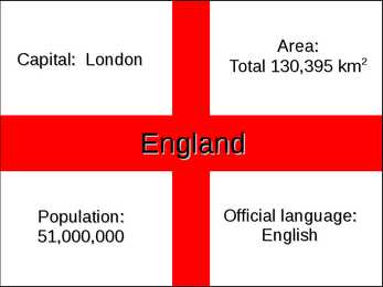
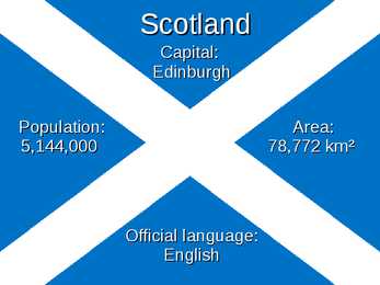
The United Kingdom and London United Kingdom is a political name of the United Kingdom of Great Britain and Northern Ireland. These political names include the countries of England, Scotland and Wales. Every country has its own capital and language. The capital of England is London, the people there are english and the language spoken is English. In scotland live the scots, capital is Edingburg and the languages spoken are English and Scottish. The capital of Wales is Cardiff, the people tehre are welsh and the languages spoken are welsh and English. N. Ireland is the home for the Irish, the capital is Belfast and the language is Irish. The first inhabitants were Iberians and Celts who settled on the land and were often at war with each other. In AD 43 Britain was made a Roman province. The romans stayed there for three hundred years. After the romans left came the Angles, Saxons and Jutes. Angles gave England its name. The population now
Hamlet Shakespeare, William Published: 1599 Categorie(s): Fiction, Drama Source: Feedbooks 1 About Shakespeare: William Shakespeare (baptised 26 April 1564 – died 23 April 1616) was an English poet and playwright, widely regarded as the greatest writer in the English language and the world's pre-eminent dramatist. He is often called England's national poet and the "Bard of Avon" (or simply "The Bard"). His surviv- ing works consist of 38 plays, 154 sonnets, two long narrative poems, and several other poems. His plays have been trans- lated into every major living language, and are performed more often than those of any other playwright. Shakespeare was born and raised in Stratford-upon-Avon. At the age of 18 he married Anne Hathaway, who bore him three children: Susanna, and twins Hamnet and Judith. Between 1585 and 1592 he began a successful career in London as an actor, writer, and part ow
1. Ancient Britain: the Celtic tribes. 2000 years ago there was an Iron Age Celtic culture throughout the Br Isles. It seems that the Celts, who had been arriving from Europe from the 8th cent BC onward, intermingled with the peoples who were already there. The Celts were extremely talented people, creative and artistic. More than 1 Celtic tribe invaded Br. The descendants of ancient Celts live in Wales, Scotland, Cornwall and Ireland. They lived in primitive society. Druids priests, more powerful than chiefs. Acted like prophets. 2. Stonehenge From prehistoric period. Was built on Salisbury plain between 2500 and 1500 bc. One of the most famous and mysterious archaeological sites in the world. One of the mysteries is how it was built at all with the technology of the time. Another is its purpose. It appears to function as a kind on astronomical clock and we know it was used by the Druids for ceremonies marking the passing of the seasons. It appears in number of novels. T
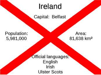
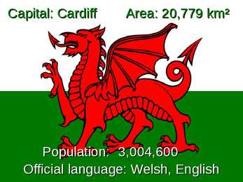
The United Kingdom The United Kingdom consists of England, Scotland, Wales and North Ireland and it is situated in the Atlantic Ocean near the mainland of Europe. The population of the UK is 58.6 million and area is 244,110 sq km. Britain has a temperate humid climate. Its characteristic features are mild winters, warm summer, no temperature extremes, abundant rain all year round and frequent changes of weather. The mild climate is partly due to the warm Gulf Stream and partly to the south westerly winds. Occasional winds from the east in winter may bring cold and dry weather. The distribution of rainfall is influenced by the Atlantic Stream. The mountainous areas of the north and west have more rain than the lowlands of the south and east. Wales is located on a peninsula in central-west Britain. The entire area of Wales is about 20,779 km². Wales borders by England to the east and by sea in the other three directions: the
1. The Queen’s official title. Elizabeth the Second, by the Grace of God, of the United Kingdom of Great Britain and Northern Ireland and of Her other Realms and Territories Queen, Head of the Commonwealth, Defender of the Faith. 2. The Queen’s working day. Starts after breakfast. Reads the newspapers which are prepared by the Press Secretary, and a report on the previous day’s proceedings in the Parliament and the letters she receives. Also phone calls. Once a month she attends the Privy Council in order to give Royal Assent to various items of government legislation. Discusses domestic matters with the Master of the Household. Towards the end of the day, there is always another pile of official papers and reports waiting to be read or acted upon. The business on constitutional monarchy never ends. 3. Who is the present heir to the throne? Speak about his education. Who are the 2nd and 3rd in line? Pre
Stonehenge One of the best known ancient wonders of the world, 5000 years old Megalith monument, built by western mediterraneans during 3000-1600 BC Circular structure, large standing stones, aligned with rising sun at teh solstice Attlers and bones were sued to dig pits that hold the stones The Celts in Britain and their legacy 700-200 BC celts invade Britain Gaels or Goehls(Ireland and Scotland),Cymri(Wales) and Brythons(gave name to Brittany) Fierce fighters,superb horsemen.Most of them farmers, lived in thatched houses Good at art, craftmanship, used iron Divided into tribes, ruled by kings, only in face of danger would they choose a single leader Legacy- hill-forts, farms, churches, field system, woodland, pasture, weapons, iron objects, langugae, culture Caesar in Britain The great Roman Emperor Firts came 55 BC to gather information, celts were doing agriculturally well,so romans wanted


Kõik kommentaarid