Recreational use of Pärnu river The catchment area of Pärnu river is 6920 km2 (For example Emajõe river drainage area is 9740 km2). The output is 70m3/s, mean altitude above the sea level - 50 m, maximum altitude - 78 m, mean flow 64,4 m3/s and precipitation 700 mm. Main problems are floods, agricultural pollution, pollution from the local communities, drainage system and flood plain grasslands. There is an excessive flooding in spring. The most known is the Soomaa swamplands flooding in april. It is called to be the fifth season. A lot of rich soil are situated near the pärnu river, for example some of the biggest farmlands are situated in the Järva county. 83% of phosphorus and 79% of nitrogen originates from human activities of the total discharge of biogenes from Pärnu River basin. The soil does not bind a huge amount of the nutrients.
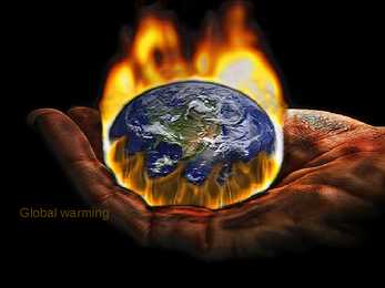
reduce mankind's ability to grow foods, destroy wildlife. Agriculture, forestry and fishery damaged Is it dangerous is very dangerous for our existence and survival. sun's scorching heat comes to earth in a direct way the earth's surface becomes seriously heated. What should we do to prevent the dangerous effects of GW? We should not cut off trees Rather we should plant more and more trees Mills, factories, brick-fields should be set up in a very good planned way. There should be well drainage system to pass away waste materials, wastages and poisonous chemicals. Thanks for listening!
2,175,600 square kilometres Greenland, a selfgoverning dependency of Denmark, is the largest island in the world. Greenland consists of an interior icecovered plateau surrounded by a mountainous, generally icefree rim. The interior ice cap is thickest near the centre of the island, where the maximum depth is estimated to be about 3,353 metres (11,000 feet). Underneath the ice cover are the ancient rocks of the Greenland Shield, which is geologically related to the Canadian Shield. Drainage is afforded mainly by the so called ice fjords, in which glaciers from the ice caps pass through valleys to the sea, where they form thousands of icebergs each year. The climate is extremely cold, although the south experiences a short summer. The mammals of Greenland are more American than European and include muskox, wolves, lemmings, and reindeer. The varieties of seal and whale, and most of the species of fish and seabird, are also American rather than European
of many islands, the largest of these is the Women's Island and the islands Pakri. Harju county has six self-governing city, a municipal city, 2 towns, 31 small towns and 395 villages. Harju county has 21 bigger cities Loksa, Nissi, Vasalemma, Paldiski, Kernu, Keila, Saue, Harku, Saku, Tallinn, Viimsi, Ostrava, Rae, Kose Kõue, Raasiku, Jõelähtme, Maardu, Anja, Kuusalu, Loksa, Aegviidu. 34 rivers flowing into the sea within the county and other watercourses, the drainage basin is the largest and tallest Jägala, Keila and the Pirita River and White River. Harjumaa Ülemiste Lake is the largest, and the Kahala Harku lake, too. Tallinn's surface water system is founded on two major reservoirs: Paunküla and Soodla. Ülemiste Lake Pirita River Jõelähtme Holy Virgin Mary Church. Jõelähtme church is one of the oldest churches in Estonia. 1220. Keila Michael's Church
half a meter away from it. The main reason of littering is behaviour. The more litter people see on the street the more inclined to litter. For example, cinema complexes, football ground and theatres are cleaned up but such areas as parks and streets are neglected. But people don't think that litter can be dangerous. It can especially be dangerous when it involves items such as broken glass, needles and syringes. Litter can get into the drainage system and block it. Litter scattered all over the city. Makes it look ugly. And it usually costs a lot of money to clean up the city every year. But the biggest problem is municipal dumps, because they cause environmental pollution. Most of the municipal dumps are filled with plastic bags, different wrapping, shopping bags and supermarket bags. We can also see empty cans from different drinks, broken glass and others. These items don't decompose naturally. They can stay on
• Low in calories • No fat • Source of vitamin A • Also contains Calcium and smaller amounts of other vitamins Cultivation indoors • Growing indoors is challenging • Basil needs alot of water • As a tropical plant, basil requires plenty of heat and light • Good soil is sphagnum, perlite and wood chip mix • Cool white or warm white fluorescent tubes on a timer work best from light • Whatever type of container you choose, be sure it has plenty of drainage holes. Cultivation outdoors • Sowing seeds “close together” • Wait until the soil is warm enough • pH should be about 6.4 • Adding compost to your soil at the beginning of the season is a great way to enrich the soil organically Companion planting • Often used as a companion plant for tomatoes • Some gardeners claim that basil can improve the growth and flavour of tomatoes and repel insects Pests and diseases
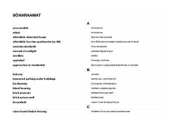
decipher välja lugema density tihedus detached house eramaja developer arendaja development values arendamisele kuuluv raha distance vahemaa distinguishable eristamatu diverse mitmekülgne domestic realm koduvaldus drainage trenaaz SÕNARAAMAT dull igav F facade fassaad facility vahend facing vastamisi
vabaneb soojuse kujul. • Üleminek hõõglampidelt LED’idele põhjustaks elektri vajaduses nii suure languse, et võiks sulgeda enam kui 250 söel töötavat elektrijaama. • Laadija vooluvõrgust väljatõmbamine säästaks 7kg CO2 eraldumist aastas. KASUTATUD MATERJALID http://www.essaywow.com/country/current-environmental-problems-facing-world-today.html http://www.123rf.com/photo_5557924_water-is-running-into-a-washbasin.html http://meinhardtindia.com/projects/sewerage-stp-and-drainage-system-ranchi-city/ http://www.orlandofiges.info/section3_RevolutionorReform/TheStolypinLandReform.php http://www.ueapme.com/business-support%20II/Training%20Tools/Confartigianato/Environment/EE-Envir onmental%20policy.pdf http://www.evogreen.co.uk/2014/03/climate-change/ http://www.delfi.ee/teemalehed/jaatmekaitlus https://ceairwithaworldtour.wordpress.com/ https://www.linkedin.com/pulse/why-europe-has-less-water-problems-than-asia-philip-teoh http://trinomics
vinyl manufacturers produce products shipped all over the world, and Edmonton's oil refineries provide the raw materials for a large petrochemical industry to the east of Edmonton. The Athabasca Oil Sands (sometimes known as the Athabasca Tar Sands) have estimated unconventional oil reserves approximately equal to the conventional oil reserves of the rest of the world, estimated to be 1.6 trillion barrels. With the development of new extraction methods such as steam assisted gravity drainage, which was developed in Alberta, bitumen and synthetic crude oil can be produced at costs close to those of conventional crude. Many companies employ both conventional strip mining and non-conventional methods to extract the bitumen from the oil sands. With current technology and at current prices, about 315 billion barrels of bitumen are recoverable. Fort McMurray, one of Canada's fastest growing cities, has grown enormously in
S. state of California · Cameroon is divided into five major geographic zones distinguished by dominant physical, climatic, and vegetative features. The coastal plain extends 15 to 150 kilometerrs inland from the Gulf of Guinea and has an average elevation of 90 meters · An irregular chain of mountains, hills, and plateaus known as the Cameroon range extends from Mount Cameroon on the coast-- Cameroon's highest point at 4,095 meters · Cameroon has four patterns of drainage. In the south, the principal rivers are the Ntem, Nyong, Sanaga, and Wouri. · The Logone flows northward into Lake Chad, which Cameroon shares with three neighbouring countries. Economy and Infrastructure · Major export markets include France, Italy, South Korea, Spain, and the United Kingdom · Cameroon is part of the Bank of Central African States and the Customs and Economic Union of Central Africa (UDEAC). Its currency is the CFA franc. · Cameroon's natural resources are
Rhodobryum roseum. Samblatest on esindatud tüviksammal, tähtsammal ja roossammal. 10 In the texture of soil sandy clay dominates. Mullalõimises domineerib liivsavi. It is but rarely covered with a layer of sand. See on harva kaetud liivakihiga. If, however, the latter is thicker than 30 centimetres, it will have such a strong influence on the condititions of growth and on the efficiency of drainage that these areas are divided into a separate sedge meadowsweet subtype. Aga kui viimatimainitul (liivakiht)on tüsedus enam kui 30 sentimeetrit, võib sellel olla tugev mõju kasvutingimustele ja kuivendamise efektiivsus (tõhusus) on need alad on jaganud erinevateks tar na-angervaksa osatüübiks. The horsetail (Equisetum) site type is common mostly in the western regions of Estonia: on leached, saturated and podzolized gley and peaty soils with heavy texture
and rivers--over 60% of the world's lakes are in Canada. Canada is rich in lakes and rivers. The largest lake is the Great Bear Lake (31,153 km²). The Great Lakes are a group of five large lakes on or near the United States- Canadian border. They are the largest group of fresh water lakes on the earth and the Great Lakes-St. Lawrence system is the largest fresh-water system in the world. They are sometimes referred to as inland seas. Rivers in Canada flow into five major ocean drainage basins: the Pacific, Arctic and Atlantic oceans and Hudson Bay. The St. Lawrence is Canada's most important river, providing a seaway for ships from the Great Lakes to the Atlantic Ocean. The longest Canadian river is the Mackenzie, which flows 4 241 kilometres through the Northwest Territories. Canada is quite mountainous. The highest point is Mount Logan with 5.959 m. It is the second-highest peak in North America. Mt. Logan is located within Kluane
absolute or relative quantity they possess within the genome) in Sponges containing gemmules were collected manually from order to assess their importance (representability). shallow depths (up to 0.5 m) from 6 sites in Estonian rivers and Previously described methods that employ PCR and direct streams from 3 drainage basins (see [7]) the Peipsi-Pihkva Lake sequencing for determining allele frequencies in pooled DNA and the Narva River drainage basin: River Piusa (specimen Pi) and PLOS ONE | www.plosone.org 1 June 2013 | Volume 8 | Issue 6 | e66601
169.Desert areas kõrbede alad 170.design- disain 171.Designed for human amenity kujundatud lähtuvalt inimeste mugavuseks 172.Desired plant soovitav taim 173.Different design- erinev disain 174.Dips- lohud 175.Discordant - vastuloluline 176.Dissemination of data andmete levitamine 177.Distinctive- eristatav 178.Distinguished silmapaistev 179.Disturb häirima 180.Dormant seisev 181.Drain kuivenduskraav 182.Drainage drenaaz 183.Dramatic piece of sculpture- skulptuuri dramaatiline osa 184.Drought-resistant- põua kindel 185.Durable- vastupidav 186.Dwelling- elamu E 187.Eccentric- iseäralik, veider, boheemne, eksentriline 188.Echo- järelkaja 189.ecology- ökoloogia 190.Efforts underway vaeva nägemine 191.Elaborate viimistletud, keerukas 192.Elevation- külgvaade 193.Embellish- kaunistama 194.Emphasized- rõhutatud 195
Surge shafts Investment in more engineering Questions? Typical Applications of ABS Piping Building Power Generation Services/HVAC Industrial Processes Water & Waste water Electronics Mining & Mineral Steelmaking & Processes Processing Sugar Processing Paper Typical Applications of ABS Piping Building Services Chilled Water Cooling Water Potable Water Wastewater Drainage Decentralised Chilled Water Building Services Typical Applications of ABS Piping Water & Wastewater Water Wastewater Water Reticulation Primary Sludge Clarifiers Secondary Sludge DAF Clarifiers Filtration DAF Chemicals Bioreactor sub surface Sludge Disposal aeration & piping Sludge handling Scrubber underflow
The two largest of them are Lake Peipsi (the fifth largest in Europe; 3 555 sq km, shared with Russia) and Võrtsjärv (270 sq. km). Of all the other lakes, only 45 have an area of more than 100 ha. Lake Peipsi and Lake Võrtsjärv are rich in fish. In Lake Peipsi you can find rare species of fish such as the lake whitefish and the Peipsi smelt. Võrtsjärv is famous for its catches of pike-perch and eel, which are regarded as a delicacy. Estonia has more than 7 000 rivers, streams and drainage ditches. Only nine are over 100 km in length. The longest, at 162 km, is the Võhandu River in the southeast, followed by the Pärnu, Põltsamaa and Pedja rivers. Forests Forest covers around one half of Estonia. The most common types of tree are pine, spruce and birch. The forests are rich in game. The forests contain elk, roe deer, wild boar, beavers, lynxes, bears and wolves. Estonia, along with Finland and Sweden are the countries with the greatest percentage of forest
Gleimullad - gley soils 7. Turvastunud gleimullad - peaty - gley soils 8. Turvasmullad - peaty soils A - Normaalse veerežiimiga mullad - normal - moistened soils B - Kuivendatud mullad - drained soils C - Kuivendamata mullad - undrained soils Joonis 2. Muldade jaotus veerežiimi ja kuivendusseisundi alusel. Figure 2. Distribution of soils depending on water regime and drainage conditions. haritavast maast 5,3 % ja 27 % neist on kuivendatud. Gleistunud muldi on haritaval maal 21,2 %, milledest 41 % on kuivendatud. Gleimullad moodustavad haritavast maast 17,58 % ja neist 81,8 % on kuivendatud. Turvastunud muldade osatähtsus haritaval maal on 2,33 %, milledest 92 % on kuivendatud. Soomuldadest on kuivendatud 94,3 %. Mehhaaniliselt koostiselt on Eesti haritava maa mullastik äärmiselt kirju (joonis 3).
-6- Psühholoogia Eestis J.Allik 2002 antiklise for modifiable movement, and resonance for memory or any dependence of behavior on past stimulation. Nor was it only the protozoa that seemed able to spare consciousness. The stereotyped behavior of the social insects, of the ants and bees, suggested that they might be robots (Boring, 1959, p. 625). Närvisüsteemi voolusängid (drainage). Uute voolusängide kujunemise teooria pakkus välja Uexküll, mis funktsionaalse ringi (tagasiside) põhimõttel loob uusi voolusänge närvivõrgus ja on seega aluseks õppimisele. Mõjutused ja arendused. · · etoloogia üks rajajatest, kellele toetused Karl von Frisch, Konrad Lorenz ja Nico Tinbergen; zoosemiootika pioneer; · · beheivioristlik programm (J.Watson) ja mentalistliku keele ärakaotamine;
there is the highest top of Estonia, Big Egg Hill (318 m), which is the highest top of the Baltic states. There are over 1400 lakes in Estonia. Lake Peipsi, lying between Estonia and Russia, covers 3 555 sq km. It is the biggest in Estonia and the fourth biggest in Europe. The second largest lake is Lake Võrtsjärv (270 sq km), while the deepest id Rõuge Suurjärv (38 m). The longest rivers are the Võhandu (162 km) and Pärnu (144 km). The Emajõgi flows for 101 km and its drainage basin covers 9740 sq km. NATURE CONSERVATION AND PROTECTED AREAS In 2004 Estonia had 360 different protected areas, apart from 448 protected parks, and over 1200 natural monuments. The total area of protected land covers over 550 000 hectares (more than 10% of the Estonian territory). Protection is extended to diverse elements such as waterfalls, hills, karst areas, outcrops, caves, lakes, craters an so on. Lahemaa National Park is the largest and oldest national park in
KULUDE LOEND Nr 2: EHITUSOBJEKTI ETTEVALMISTAMINE BILL No 2: SITE CLEARANCE 1 036 918,000 KULUDE LOEND Nr 3: MULLATÖÖD BILL No 3: EARTH WORKS 1 034 935,000 KULUDE LOEND Nr 4: KATEND BILL No 4: PAVEMENT CONSTRUCTION 27 189 362,932 KULUDE LOEND Nr 5: TRUUBID JA VEEVIIMARID BILL No 5: CULVERTS AND DRAINAGE 10 400,000 KULUDE LOEND Nr 6: EHITISED BILL No 6: STRUCTURES 65 250,000 KULUDE LOEND Nr 7: LIIKLUSKORRALDUSVAHENDID BILL No 7: TRAFFIC ORGANISATION AND SAFETY EQUIPMENT 170 480,000 KULUDE LOEND Nr 8: TEHNOVÕRGUD BILL No 8: UTILITIES 48 275,000
be contaminated for hours to days, but infection is not a likely result. Following the tips above is the most effective means of preventing MRSA infection. If you suspect an MRSA infection, what should you do? Closely watch minor skin problems -- pimples, insect bites, cuts and scrapes -- especially in children and older adults. If wounds become infected, see your doctor. Indications of an infected wound include increasing skin redness, swelling, warmth, tenderness, pus drainage 4 and sometimes fever. If you test positive for staph infection, ask that the skin culture growing staph be tested for MRSA. Drugs that treat ordinary staph aren't effective against MRSA. Using these ineffective drugs could lead to serious illness and more resistant bacteria. MRSA: riski hindamine ja infektsiooni leviku tõkke. MRSA e. Metitsiliin - resistentne Staphylococcus aureus on suureks probleemiks haiglate
The Great Lakes--the world's largest surface of fresh water--are shared with the United States and form part of the international border. Other large lakes include Great Bear and Great Slave lakes in the Northwest Territories and Lakes Manitoba and Winnipeg in Manitoba. Mackenzie River is Canada's longest river, which flows 4,241 km from its source to its mouth. With its many tributaries, it drains 1,800,000 square km. The St. Lawrence is the largest river flowing into the Atlantic Ocean. Its drainage basin includes the Great Lakes, forming an inland navigable waterway extending some 3,765 km into the heart of the continent. The longest Pacific-draining river that is wholly within Canada is the Fraser. The Yukon and Columbia rivers, which both rise in Canada, also flow to the Pacific, but they do so through the United States. Five of Canada's rivers -- the St. Lawrence, Mackenzie, Yukon, Fraser, and Nelson -- rank among the world's 40 longest. 5. The territories and provinces
eastern part of the country. The Murray River is the largest but the second longest river, only its tributary the Darling river is longer than it. The Murray rises in the Australian Alps and flows north-west. It makes up much of the border of the New South Wales and Victoria. The Murray-Darling river system is one of the largest river systems in the world. There are predominantly dry salt lakes in the flat desert regions of the country lacking in organised drainage. The Australians can get most of their underground water from the Great Artesian Basin, which is the largest and deepest artesian basin in the world. Iti is near Lake Eyre, the Great Dividing Range and the Simpson Desert. An artesian well is a confined aquifer containing groundwater that will flow upwards through a well without the need for pumping. Water may even spurt out of the ground if the natural pressure is high enough. An aquifer provides the water for an artesian well
Sunflower stover contains a large proportion of these elements, which means sunflower is relatively inefficient in the use of these elements. However, most of these nutrients are returned to the soil with the stover. Sunflower is low in salt tolerance but is somewhat better than fieldbean or soybean in this respect. Corn, wheat, rye and sorghum are rated medium, and sugarbeet and barley are high in salt tolerance. Good soil drainage is required for sunflower production, but this crop does not differ substantially from other field crops in flooding tolerance. V. Cultural Practices: A. Seedbed Preparation: Many different tillage systems can be used effectively for sunflower production. Conventional systems of seedbed preparation consist of moldboard plowing or chisel plowing to invert residue and several secondary field operations. Conventional systems
Results show that yearly growth of bog pines was the biggest during 1960-1990 - clear agreement with earlier studies. During last decades the growth has dropped: in Kõrgesoo back to level of 60s, in Puhatu on slightly higher level. Thus, nice agreement with the use of oil shale - the main source of alkaline and nutrient-rich pollution in area is observable. Changes in growth rates were well correlated with the distance of bogs from power plants, age of trees and at Selisoo also with drainage activities. The increase and drop of growth is the most evident for younger trees and almost zero for trees over 100 years old. Thus, younger trees are recommended to study nutrient load influence on growth of trees in bogs Keywords: bog pine, radial growth, alkaline pollution, nutrients, age of trees 3 SISUKORD SISSEJUHATUS ................................................................................................................... 5 1
wood rot decay. 27% of the samples taken from the lower logs of the external wall, roof rafters and floor beams were damaged by the wood rotting fungi. 10% of the buildings had some damage from wood rotting fungi in the bottom beam of the external wall. The load- bearing structures of two buildings were damaged by dry rot (Serpula Lacrymans). Envelope structures such as siding, exterior window sills, rainwater drainage, and roof covering often need renovation to protect the load-bearing structures from further damage. The main causes of damage and flaws in the foundations were the uneven subsidence of the foundation, the empty spaces between bricks where the mortar had fallen out, foundations that were too low (or ground elevation of the surrounding area) and the failure to protect the edge of the foundation from rain water, or the decay of the slope made of mortar for that purpose.
DIVIDE: The boundary or high ground between river systems, Srr eams In North Am erica a conrinenral divide called the Great Di vide o n one side of rh e divide flow in a different direcrion and into a runs along th e crest of th e Rocky Mounrains, d ividin g rivers that d ifferent drainage basin from th e strea ms on the other side. A flow ro the Gulf of Mexico and the Atlantic Ocean fro m th ose continental divide is the boundary that separates the rivers th at flow into the Pacific Oc ea n . An o rhe r much lower d ivide flowing roward opposite sid es of a continent
The name was derived from the tribal name of Britons (or Brits) who inhabited most of the occupied territory. The Roman name eventually lost its ending and became shortened to ‘Britain’. The basis of Roman civilization and administration was the towns. Many grew out of Celtic settlements, military camps or market centres. The Romans built most towns to a standardized pattern of straight, parallel streets that crossed at right angles. 22 The paved streets4 had drainage systems, and fresh water was piped to many buildings. There were three different kinds of town in Roman Britain. Some were peopled by Roman citizens. In others the native townspeople were given Roman citizenship. The third kind included the old tribal capitals through which the Romans administered the Celtic population in the countryside. By AD 300 all towns had thick stone walls5. The towns were connected by roads which were so well built that they
chronically inflamed tissues with abnormal calcium deposits. Now, Lee was using me to test her latest and greatest: biopuncture. Coined in 1991 by Jan Kersschot MD, a Belgian physician, "biopuncture" involves shallow injections of di erent substances, including Traumeel, zdeel, and lymphomyosot. Traumeel is typically used for acute in ammation from sports injuries, and lymphomyosot is utilized for lymphatic drainage in chronically swollen or congested tissue. Traumeel has been shown in some peer-reviewed journals to shorten recovery time from acute sports injuries and inhibit the secretion of immune mediators (IL-1B and TNF-alpha) that are associated with tissue damage and increased inflammation. Though biopuncture solutions aren't diluted to the extent that they contain no active product (like most homeopathic medicine), they are diluted and referred to as "microdoses." Lee used
hygienically. Electrical stunning, followed Bag Curing by prompt sticking, has been the usual This process differs in that it has no immer- method, although this is being superseded by sion stage. Instead, the boneless pieces carbon dioxide stunning throughout Europe. are injected and, after a short drainage Singeing the carcass improves the sliceability period, placed in a moisture- and oxygen- of rind-on product. impermeable bag, vacuum sealed, and held Toughness is not a problem in bacon, so for a minimum of two days to allow time for interventions to improve tenderness (e.g., hip