The Prarie Provinces Main Facts The Prairies comprise the states of Alberta, Saskatchewan and Manitoba Covers about 2,1 million square kilometers. About 5,7 million people live in that region. What is a Prarie? Prarie (aslo known as a temperate grassland) is a treeless ecozone in North America. Different names in different countries. Only about 400 mm per year. Hot summers and cold winters. Humans and the Prairies Almost 95 % of the Prairies are converted into farmland. The biggest towns are Calgary, Saskatoon and
Atlantic Ocean in the east to the Pacific Ocean in the west and northward into the Arctic Ocean. It is the world's second largest country by total area, and shares land borders with the United States to the south and northwest. Canada is a federation composed of ten provinces and three territories; in turn, these may be grouped into regions. Western Canada consists of British Columbia and the three Prairie provinces (Alberta, Saskatchewan, and Manitoba). Central Canada consists of Quebec and Ontario. Atlantic Canada consists of the three Maritime provinces (New Brunswick, Prince Edward Island, and Nova Scotia), along with Newfoundland and Labrador. Eastern Canada refers to Central Canada and Atlantic Canada together. Three territories (Yukon, Northwest Territories, and Nunavut) make up Northern Canada. Provinces have a large degree of autonomy from the federal government, territories somewhat less
major mountain resorts near the city and metropolitan area. Economic activity in Calgary is mostly centred on the petroleum industry; however, agriculture, tourism, and high-tech industries also contribute to the city's economic growth. In 1988, Calgary became the first Canadian city to host the Olympic Winter Games. Winnipeg Winnipeg is the capital and largest city of Manitoba, Canada.It's population is 740 000 people. It is located near the longitudinal centre of North America, in south central Canada, near the eastern edge of the Canadian Prairies, at the confluence of the Red and Assiniboine Rivers.Winnipeg is the primary municipality in the Winnipeg Capital Region, which is home to more than sixty percent of Manitoba's population. The name Winnipeg comes from the Cree words meaning muddy water, referring to Lake Winnipeg 60 kilometres to the north.
1763 New France is formally ceded to Britain; Pontiac Rebellion erupts 1783 Loyalist refugees begin arriving after the American Revolution 181214 War of 1812: U.S. invades Canada 183738 Rebellions against British rule in Upper and Lower Canada 1848 Responsible government is won, first in Nova Scotia, then in Canada 1867 Confederation (first four provinces: Québec, Ontario, N.S., and N.B.) 1870 Red River Resistance; province of Manitoba is created 1871, 1873 B.C. and P.E.I. join Canada 1885 North-West Rebellion; the Canadian Pacific Railway is completed 1905 The provinces of Alberta and Saskatchewan are created 191418 World War I 1916 Women win the vote in Manitoba, Saskatchewan, and Alberta 1919 The Winnipeg General Strike 192939 The Great Depression 193945 World War II 1949 Newfoundland joins Canada 195053 Korean War 1959 St. Lawrence Seaway (major transportation route) officially opens
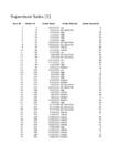
4.2 Sample Company A Alberta West 1.99 Tamara Dahlen Ontario Ontario 0.7 Arthur Gainer Alberta West 3.92 Jonathan Doherty Saskachewan Prarie 0.7 Jonathan Doherty Saskachewan Prarie 2.58 Helen Wasserman Quebec Quebec 5.99 Helen Wasserman Quebec Quebec 8.99 Keith Dawkins Manitoba Prarie 0.5 Craig Yedwab Yukon Yukon 8.19 Pauline Chand Ontario Ontario 13.99 Roy Collins Saskachewan Prarie 9.03 Roy Collins Saskachewan Prarie 9.45 Roy Collins Saskachewan Prarie 5.03 Emily Phan Quebec Quebec 54.74 Emily Phan Nova Scotia Atlantic
KANADA Üldandmed Pealinn: Ottawa Keeled: inglise & prantsuse Pindala: 9 984 670 km² Rahvaarv: 33 617 000 Rahvastiku tihedus: 3,3 in/km² Iseseisvus: 1.juuli 1867 Haldusjaotus Föderatsioon, kus 3 ala: Loodealad, Nunavut ja Yukoni ala. Jaotatud 10 provintsiks: Alberta, Briti Columbia, Manitoba, New Brunswick, Newfoundland ja Labrador, Nova Scotia, Ontario, Prints Edwardi saar, Québec, Saskatchewan Haldusjaotus Valitsus Kanadas on parlamentaarne demokraatia ja konstitutsiooniline monarhia. Riigipea: Elizabeth II, Kindralkuberner: Michaëlle Jean Peaminister: Stephen Harper Monarh riigi sümbol - esindaja. Ajalugu 15
Põhja-Jäämere, Atlandi kui ka Vaikse ookeani ääres, samuti kaks teineteisest lahus paiknevat maismaapiiri USA-ga. Lääneservas piirneb Kanada Alaska osariigiga, peamine piir naabriga aga jookseb 6400 km pikkuselt mööda riigi lõunaosa. 3 Kanada on jaotatud 10 provintsiks ja 3 territooriumiks ehk alaks (tähistatud märgiga*) 1. Alberta 2. Briti Columbia 3. Loodealad* 4. Manitoba 5. New Brunswick 6. Newfoundland ja Labrador 7. Nova Scotia 8. Nunavut* 9. Ontario 10. Prints Edwardi saar 11. Québec 12. Saskatchewan 13. Yukon* 1.2 Pinnamood Kanada hiigelmõõtmed tähendavad geograafilist mitmekesisust. Riigi saab jagada viieks selgesti erinevaks suureks piirkonnaks. Peaaegu poole mandriosast hõlmab suur Kanada kilp ehk Laurentia kiltmaa – avar,
Kanada suurim jõgi Kanada suurim jõgi on Mackenzie jõgi, mis koos lisajõgedega seob enamikku Kanada kilbil asuvaid järvi ja viib oma vee jäämerre. Kanada järved Kanada on kõige järverikkam maa maailmas, neid on seal umbes 200 000. Kokku on riigi pindalast järvede all 891 163 km². See on umbes sama suur kui Pakistan või Türgi. Kagupiiril asub Suur järvistu. Tuntud ja tähtsad järved on Suur Karujärv Suur Orjajärv Athabasca Wollastoni Põdrajärv Manitoba Winnipegi Nipigoni järv Metsajärv Loodus Peaaegu poolt Kanada territooriumi katavad metsad. Põhjas levib arktiline ja lähisarktiline taimestik, tasandikuprovintsides rohtlad. Tihedates okas ja väärispuumetsades kasvavad kuused, tsuugad, palsamnulud, mitut liiki mände ja seedreid Tüüpilisemad puud Mänd Kuusk Seeder Kanada tsuuga
The St Elias Mountains in the Yukon include Canada's highest peak, Mount Logan. It towers 5,951 metres above sea level. Because the Coast Mountains are on the seashore, the coast of British Columbia has many long, narrow inlets called fiords. The fiords provide a water route to Canada's most valuable forests. These forests consist of red cedars, hemlocks, and other evergreen trees that grow on the lower mountain slopes. Alberta, Saskatchewan, and Manitoba are Canada's Prairie Provinces. They are known for their rolling plains and extreme climate with long, cold winters and hot, dry summers. Much of the area is covered with farms producing large quantities of wheat and other grains. The region is also rich in oil and natural gas. Northern Saskatchewan and Manitoba are covered by the Great Canadian Shield a rocky landscape with lakes, rivers and forests. The Canadian Shield is a vast horseshoe-shaped region.
4. Rivers, lakes With less than 1 percent of the world's population, Canada has some one-seventh of the world's supply of accessible fresh water. Much of this water is stored in lakes and wetlands that cover about one-fifth of Canada's total area. The Great Lakes--the world's largest surface of fresh water--are shared with the United States and form part of the international border. Other large lakes include Great Bear and Great Slave lakes in the Northwest Territories and Lakes Manitoba and Winnipeg in Manitoba. Mackenzie River is Canada's longest river, which flows 4,241 km from its source to its mouth. With its many tributaries, it drains 1,800,000 square km. The St. Lawrence is the largest river flowing into the Atlantic Ocean. Its drainage basin includes the Great Lakes, forming an inland navigable waterway extending some 3,765 km into the heart of the continent. The longest Pacific-draining river that is wholly within Canada is the Fraser
country, with both English and French as official languages. Geography: Covering most of the northern part of the North American continent and with an area larger than that of the United States, Canada has an extremely varied topography. In the east, the mountainous maritime provinces have an irregular coastline on the Gulf of St. Lawrence and the Atlantic. The St. Lawrence plain, covering most of southern Quebec and Ontario, and the interior continental plain, covering southern Manitoba and Saskatchewan and most of Alberta, are the principal cultivable areas. They are separated by a forested plateau rising from Lakes Superior and Huron. Westward toward the Pacific, most of British Columbia, the Yukon, and part of western Alberta are covered by parallel mountain ranges, including the Rockies. The Pacific border of the coast range is ragged with fjords and channels. The highest point in Canada is Mount Logan (6,050 m), which is in the Yukon. The two principal river
government: federal, provincial and local or munucipal. These governments are elected and, therefore, are directly responsible for their actions to the electorate. Population of Canada is about 35 million and territory about 10 million square kilometers, about one-thirteenth of the entire land area of the world. So the population density is 3.5 persons per sq.km. There are 10 provinces and 3 territories. The biggest provinces are Alberta, British Columbia and Manitoba. The biggest city is Montreal with 3.8 million people. The capital Ottowa has only 1.2 million people and is listed fourth biggest city. 32% of population is Canadian, 21% is English and 15.8% is French. First Nationist are only 4%. 80% of Canadians live in 3 urban areas concentrated in the Quebec City- Windsor Corridor, the British Columbia Lower Mainland, and the Calgary-Edmonton Corridor. 80% of the population live within 150km of the US border; 90% lives within 300km of the US border
The monarchy is represented by the leutenantgovernor. The Frenchspeaking province of Canada (Quebec) is very different culturally. Since the 1960s there has been a strong movement to became an independent country (separatist movement). 80 % of Canada's French speaking people lives in Quebec. Canada has ten provinces and two territories (the capital of each is shown in parentheses): Alberta (Edmonton), British Columbia (Victoria), Prince Edwars Island (Charlottetown), Manitoba (Winnipeg), New Brunswick (Fredericton), Nova Scotia (Halifax), Nunavut (Iqaluit), Ontario (Toronto), Quebec (Quebec City), Saskatchewan (Regina), Newfoundland and Labrador (St. John's), Northwest Territories (Yellowknife) and Yukon Territory (Whitehorse). Geographically, Canada can be divided into five major regions: the Pacific Region, the Prairie Provinces, Central Canada, the Atlantic Provinces and the North. The Pacific Region includes Canada's westernmost
Liivia Lints KA Mag I Sisukord Sissejuhatus Sööda tüübid Sööda koostis Söödakoefitsient Söötmisreziim Söödanorm Söötmise meetodid Kokkuvõte Sissejuhatus Läbi aegade on kasutatud kalakasvatuses erinevaid söötasid Forellitiikides looduslik söödabaas praktiliselt puudub, mistõttu juurdekasv saadakse antava sööda arvelt Söödakulud võivad moodustada kasvatatud kala omahinnast kuni 60 %. Söödad on nii koostiselt kui ka suuruselt erinevad Söödatüübid (1) Toores kala Oht, et kalad saavad toorest söödakalast parasiite või haigusi. Toore räime söötmine võib põhjustada B1-vitamiini vaegust Eesti mageveekalades esineb inimest nakatava laiussi Diphyllobothrium latum plerotserkoide Söödatüübid (2) Pasta- ehk märgsööt Kogus Komponent % Valmistati läbi hakkliha-masina Värske püügikala 60 ...
There are also people of German, Italian, and descent. Eskimos and American Indians together make up about 2% of the population. Over three-quarters of Canada's people live in cities or towns. Provinces/territories Canada is divided into provinces and territories. There are 10 provinces and 3 territories. The provinces are Newfoundland, New Brunswick, Prince Edward Island, Nova Scotia, Quebec, Ontario, Alberta, Saskatchewan, Manitoba and British Columbia. Quebec Quebec differs greatly from the rest of Canada because of its French language and culture. About 80% of Quebec's people are of French descent. The official language is French. Quebec is the largest province in area and the second largest in population. Ontario Ontario has a larger population than any other province. About a third of Canada's people live there. About half of Ontario's people are of British or Irish descent. Ontario produces
They eat insects and grass. Land. Canada is divided into five major regions geographically: the Pacific Region, the Prairie Provinces, Central Canada, the Atlantic Provinces and the North. The Pacific Region includes British Columbia. The region is known for its mild coastal climate, its forests and its spectacular mountains, including the famous Rocky Mountains. Vancouver and Victoria are the largest cities in this area. Alberta, Saskatchewan and Manitoba are Canada's Prairie Provinces. They are known for their rolling plains and extreme climate with long, cold winters and hot, dry summers. Much of the area is covered with farms producing large quantities of wheat and other grains. Manitoba and Saskatchewan are covered by the great Canadian Shield-a rocky landscape with lakes, rivers and forests that stretches over almost half of Canada. Central Canada includes Ontario and Quebec. It really isn't in the center of
Territory and landscape Canada is one of the largest countries in the world. It covers nearly 4 million square miles. It is dividend into ten provinces( British Columbia, Manitoba, New Brunswick, Alberta, Nova Scotia, Ontario, Prince Edward Island, Quebec, Saskatchewan, Newfoundland ) along with two territories( the Yukon, the Northwest territories ). The capital city is Ottawa. Canada is a country rich in forests. It borders in the south with The United States and it's surrounded in the west by the Pacific Ocean, in the east by the Atlantic Ocean and above by many smaller bays, but is also borderedd with Alaska in the north-west. To the north of
pharmaceuticals, aerospace products, and telecommunications equipment. Ontario is the nation's main industrial center. About half of all Canadian manufactured goods are produced in Ontario. The province is second only to Michigan as the largest producer of automobiles and car parts in North America. Ottawa, the nation's capital, is located in Ontario. Other industries include chemicals, aerospace, steel, and food processing. The plains (or prairie) provinces of Alberta, Manitoba, and Saskatchewan are the home to four-fifths of Canada's agricultural lands. They are also the home to the majority of mining and fuel production. Alberta itself provides 90 percent of the nation's energy exports and is the home of Canada's oil and natural gas industry. British Columbia is in the Pacific Northwest. Forestry and tourism were traditionally the main elements of the region's economy, but financial services, including banking and insurance, have grown
the famous Rockies which are also the youngest and highest mountains in Canada. British Columbia is in the landform region called the Western Cordillera (system of mountain ranges). Between the mountain ranges are areas of high plateaus and deep trenches. Since the landscape is very rugged, most people live in the south and near the coast. Vancouver and Victoria are the largest cities in British Columbia. Alberta, Saskatchewan, and Manitoba are Canada's Prairie Provinces. They are known for their rolling plains and extreme climate with long, cold winters and hot, dry summers. Much of the area is covered with farms producing large quantities of wheat and other grains. The region is also rich in oil and natural gas. The Prairie Provinces are not only characterized by their rolling plains but also the great Canadian Shield a rocky landscape with lakes, rivers and forests
The Pacific Region, which is the western part of Canada, consists of one province: British Columbia. It became a province in 1871. Its capital is Victoria and the biggest city is Vancouver. Name of British Columbia was chosen by Queen Elizabeth. The main industries are forestry, tourism (Vancouver Island, Stanley Park, skiing, golfing, hiking), mining (metal and coal mines) and fishing. The Prairie Provinces, that are located in the middle and south of Canada, consist of three provinces: Manitoba (capital Winnipeg), Alberta (capital Edmonton) and Saskatchewan (capital Regina). Agriculture is very important in that region. There are many farms where they grow wheat, barley and oats. The most important landmarks of the region are the Canadian Shield, Lake Winnipeg and the Rocky Mountains, but it mostly consists of plains. Central Canada consists of Quebec (capital Quebec City) and Ontario (capital Toronto). It's
hõredamaid - kõigest 2,9 inimest km²-l. Linnarahvastiku osakaal oli 1996. aastal 76,6% ja rahvarohkeimad linnad olid Toronto (423 757), Montreal (3 326 510), Vancouver (1 831 665) ja Ottawa-Hulli linnastu oma 1 056 000 elanikuga. Torontos, Vancouveris ja Montrealis ehk riigi kolmes suurimas linnas elab kokku koguni 31% kogu Kanada rahvastikust. Haldusjaotus. Kanada jaotatakse 10-ks provintsiks ja 2- ks territooriumiks. Provintsid on Alberta, Briti Kolumbia, Manitoba, New Bruinswick, Newfoundland ja Labrador, Nova Scotia, Ontario, Prints Edwardi saar, Quebec ja Saskatchewan. Kaks territooriumi on Yukoni ning Loodeterritoorium. Majandus. Kanada on väga kõrgelt arenenud riik (kuulub niinimetatud "Põhja" riikide hulka), mida ilmekalt tõestab see, et RKP ehk sissetulek ühe inimese kohta oli 1996. aastal koguni 22 333$. Kõrget arengutaset näitab ka see, et põllumajandus andis kõigest 2%, tööstus 26%, teenindus aga koguni 72% RKP-st.
Riigi ametlik nimetus: Kanada (Canada) Pindala: 9 984 670 km² Pealinn: Ottawa Rahvaarv: 33,03 mln. Rahvastiku tihedus: 3,3 elanikku ruutkilomeetri kohta Rahvastiku juurdekasv: 0,967% Riigitähis: CAN Rahaühik: kanada dollar Riigikeeled: inglise keel ja prantsuse keel Haldusjaotus: jaotatud 10 provintsiks ja 3 territooriumiks Provintsid: Territooriumid: Alberta Yukoni ala Briti Columbia Loodealad Manitoba Nunavut New Brunswick Newfoundland ja Labrador Nova Scotia Ontario Prints Edwardi saar Québec Saskatchewan Poliitiline süsteem: Parlamentaarne monarhia Riigipea: Kuninganna Elizabeth II (kohapeal asendab kindralkuberner Michaëlle Jean) Valitsusjuht: Peaminister Stephen Harper Seadusandlik võimuorgan: Kanada Parlament (House of Commons and Senat) ja igal provintsil on veel omakorda valitsus ja parlament Linnastumine: 83% elab linnades
front vowel. To properly learn which is which, IPA provides: https://www.youtube.com/watch?v=PsfQESpi-Ec Furman University. Phonology: Vowels. Available at http://facweb.furman.edu/~wrogers/phonemes/phono/phvowel.htm, accessed January 19, 2016. Foley, Dan. 2008. IPA back, front and mid vowels. Available at https://www.youtube.com/watch? v=PsfQESpi-Ec, accessed January 19, 2016. University of Manitoba. 2014. Describing English Vowels. Available at http://home.cc.umanitoba.ca/~krussll/phonetics/articulation/describing-vowels.html, accessed January 19, 2016. Michigan State University. 2003. Phonetics: the physical part of speech, again. Available at https://www.msu.edu/course/lin/401/fs03-s2/phonetics-lecture2.pdf, accessed January 19, 2016. FORTIS CONSONANTS
Protégera nos foyers et nos droits 1.2 Riigi geograafiline asend (Lisa 1) Kanada on suuruselt maailma teine riik. Ta on Põhja- Ameerika üks riike. Kanada ulatub põhja Ellesmere´i maa Colombia neemeni ja lõuna Erie järve Middle´i saareni. Ta paikneb 5 ajavööndis ja on jaotatud kümneks provintsiks ja kolmeks territooriumiks. Hudsoni lahe ümber paiknevad sisetasandikud, mis hõlmavad ka Kanada kilbi, moooodustavad 80% Kanada maismaast. Kilbist läänes Saskatcewani ja Manitoba tasandik laiuvas tohutud preeria- alad. Kõige Tihedamalt on asustatud Saint Lawrence´i jõe ja Suure järvistu äärsed madalikud. Kanada peamised jõed Saint Lawrence, Yukon, Mackenzie ja Frazer kuuluvad maailma 40 suurima jõe hulka. Viimaseil aastail on prantsuse keelt kõneleva Quebeci ja ülejäänud riigi poliitilised suhted põhiseaduslik võtmeküsius. 6 Tiiu Taplas 1.3 Looduslikud tingimused (Lisa 1) 1.3.1 Pinnamood
3 Kas see oli eetiline uuring? Minu arvates ei olnud tegemist eetilise uuringuga, sest uuriti kahjulikku ekspositsiooni, mille kohta oli juba eelnevatest uuringutest teada, et ümberlõikamine mõjutab nakatumist HIV infektsiooni. Uuringu protokoll oli küll üle kontrollitud erinevate eetika- ja uurimiskomisjonide poolt (Kenyatta National Hospital;Univercity of Illinois;Univercity of Manitoba; Univercity of Washington). Uuring katkestati enneaegselt, kuna tulemused ümberlõigatud meestel ja ravi mittesaanutel olid niivõrd erinevad ümberlõigatud meeste kasuks. 4
Regions in Canada Canada is divided into five major regions. The Pacific Region The Pacific Region consists of only one province - British Columbia. It is known for its mild coastal climate, forests and the Rocky Mountains. The Rocky Mountains are the youngest and the highest mountains in Canada. Largest cities are Vancouver and Victoria. Only 5% of The Pacific Region is inhabitable. The Prairie Provinces The Prairie Provinces consists of Alberta, Saskatchewan and Manitoba provinces. Population in that region is about 5.7 million people. The precipitation in The Prairie Provinces is very low only 400 mm per year. The biggest cities are Calgary, Winnipeg and Saskatoon. The Prairie Provinces focus on farming. 95% of the land in that region has been converted into farmland. Mostly wheat and other grains are produced. Cattle and sheep ranching is also part of the agriculture. The Prairie Provinces are known for their rolling plains and extreme climate with long,
communities were considered to be somewhat distinct constituencies -- the derogatory nature of the term "Half- breed" has caused it to fall largely into disuse. Thus, the contemporary meaning of "Métis" typically includes people of both French- and English-speaking heritage. 5. In which of the present provinces did the "classic" Métis culture develop? Who was the most famous leader of the Métis? The "classic" Métis culture emerged near present-day Winnipeg, Manitoba. The most famous Métis leader Louis Riel was the founder of Manitoba and also a central figure in the Red River and North-West resistances. Riel led two popular Métis governments, was central in bringing Manitoba into Confederation, and was executed for high treason for his role in the 1885 resistance to Canadian encroachment on Métis lands. Riel was initially dismissed as a rebel by Canadian historians, although many now sympathize with
Alberta is rich in natural resources such as oil and natural gas. In Quebec and Ontario are many manufactories and industries. In the west there is maritime climate and so they fish and ship there. Toronto is the biggest city in Canada, with a population of 5,1 million people. It is followed by Montreal with 3,9, Vancouver, Ottawa (which is the capital of Canada) 800 000 and Quebec with 700 000. Government Canada is a federation of ten provinces (Alberta, British Columbia, Manitoba, New Brunswick, Newfoundland and Labrador, Nova Scotia, Ontario, Prince Edward Island, Quebec, and Saskatchewan) and three territories (Northwest Territories, Yukon, and Nunavut). Formally considered a constitutional monarchy, Canada is governed by its own House of Commons. While the governor-general is officially the representative of Queen Elizabeth II, in reality the governor-general acts only on the advice of the Canadian prime minister.
Canada and covers more of the country than any other type of vegetation. The Maritimes are home to the Acadian forests which are made up from spruce, for, birch, pine and maple trees. West of the Maritimes in Quebec and Ontario are the Laurentian Forests and Mountains leading into the Canadian Shield in the north and the Great Lakes in the south and west of Ontario. Manitoba, Saskatchewan and Alberta make up Canada's prairie grasslands which contain mixed grasses but are mainly covered by farmed grains. Alberta and the east of British Columbia contain Canada's Rocky Mountains which stretch up into the Yukon Territory from the United States. Spruce, fir and larch trees can be found amongst the rocky and often snow covered terrain. British Columbia's Pacific Coast contains mountains
, Mäler, K.-G., Perrings, C., Pimentel, D. (1995). Economic Growth, Carrying Capacity, and the Environment. Science vol 268. American Association for the Advancement of Science. Baltic Environmental Forum (2000). 2nd Baltic State of the Environment Report based on environmental indicators. Riga. BEF. Bossel, H. (1999). Indicators for Sustainable Development: Theory, Method, Applications. A Report to the Balaton Group. Winnipeg, Manitoba Canada. International Institute for Sustainable Development. Eesti inimarengu aruanne (2000). Tallinn. Elanike usaldus valitsuse vastu on järsult langenud (2000). Eesti elanike usaldus poliitiliste institutsioonide vastu on langenud viimase viie aasta kõige madalamale tasemele. - Postimees, 7. dets. Hamilton, K. (2000). Genuine Saving as a Sustainability Indicator. The World Bank Environment
nominated by the Prime Minister, approved by the National Assembly, and appointed by the President. Members of the government are often styled "cabinet ministers”. 38. Symbols and the flag of Ireland. Shamrock, Celtic Cross, Triple Knot, Irish Harp Irish flag is a is a vertical tricolor of green (at the hoist), white, and orange. 39. Provinces and territories of Canada. The ten provinces are Alberta, British Columbia, Manitoba, New Brunswick, Newfoundland and Labrador, Nova Scotia, Ontario, Prince Edward Island, Quebec, and Saskatchewan. The three territories are Northwest Territories, Nunavut, and Yukon, which govern the rest of the area of the former British North America. 40. National anthem and flag of Canada. National anthem is “O Canada”. The flag of Canada consists of a red field with a white square at its center in the
contexts. The Union Jack is, for example, displayed in the canton of the British Blue Ensign and the British Red Ensign. It also constitutes part of the flags of the Commonwealth nations such as Australia (and its states New South Wales, Queensland, South Australia, Tasmania, Victoria, and Western Australia), New Zealand and Tuvalu; and, in addition, of the U. S. State of Hawaii and the three Canadian states of British Columbia, Manitoba, and Ontario. 1.5 National Flags as Political Instruments National flags constitute a powerful instrument for communication and participation. This is one reason why flags are not merely colourful ornaments. Instead, identification and representation are the key functions of the earliest kinds of symbolism. Symbolic devices have been employed to identify groups and territories throughout history, while, at the same time, they have been used symbolically to differentiate communities from one
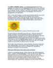
Oil-Type Sunflowers Sunflowers grown for oil are characterized by black hulls. With oil-type sunflowers there are 3 different groupings: traditional, mid-oleic (NuSun), and high oleic. These groupings are based according to their specific oil profile. The mid-oleic varieties have an oil profile that is intermediate to the traditional and the high-oleic sunflower varieties. Currently most of the sunflower varieties recommended and grown in Manitoba are of the conventional oil type. Name: The botanical name is Helianthus. The Greek word "helios" means sun and "anthos" means flower. It is aptly named after the sun which it resembles. Description: A large flower head with usually a big dark centre and bright yellow petals. Origin: South and West of the USA. Colour: Most sunflowers are bright yellow with dark brown centres, but varieties are appearing now which have tan, orange, maroon or striped petals, and green-yellow centres
- lil1l ~ ~ == .-, , Alberta t Sask a tch ewan Manitoba Nova Sco tia Ontario New Brunswick Internatio nal boundary Provincial bo undary Mountain peak ~lS0OW Labrador J?0""