USA USA capital is washington. Population · 2017 estimate 325,365,189[8] . Largest city is New York Presitent is donald trump. Usa national bird is eagle. LOGATION Staes Iceland, Mainland and west of Canada, and Hawaii. USA mainland in the Pacific Ocean. LANGUAGE English. Spanish European PHOTOS Thx for listening
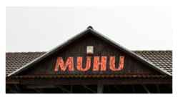
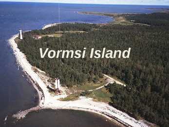
With an area of 198 km2 it is the third largest island belonging to Estonia, after Saaremaa and Hiiumaa. Together with neighbouring smaller islands of Kesselaid, Viirelaid, Võilaid and Suurlaid it forms Muhu Parish. The island has a population of 1,697 (as of 19 April 2010) and covers an area of 206.12 km2. The population density is 8.8/km2. Geography • The most important villages in Muhu are Kuivastu, Liiva and Koguva. It is linked by ferry to Virtsu in the mainland, and to Saaremaa by a causeway, the Väinatamm. In winter an ice road connects the island to the mainland. The same waters saw the Battle of Moon Sound in September–October 1917 between Russian and German naval forces. Muhu is also famous for having the only still-working traditional windmills in Estonia. Muhu is the home of Estonia's first wine tourism farm – Luscher & Matiesen Muhu Winehouse.
Thylacine AKA the Tasmanian Tiger/Wolf • The Tasmanian Tiger was the largest known carnivorous marsupial of modern times. • Native to continental Australia, Tasmania and New Guinea. • Believed to have become extinct in the 20th century. • Became extremely rare or extinct on the Australian mainland before British settlement of the continent, but it survived to the 1930s on the island of Tasmania. https://www.youtube.com/watch?v=6vqCCI1ZF7o • The thylacine was able to open its jaws to an unusual extent: up to 120 degrees. This capability can be seen in part in David Fleay's short black-and- white film sequence of a captive thylacine from 1933. The jaws were muscular but weak and had 46 teeth. • The thylacine held the title of
Alaska is the least densely populated state of the U.S. 2 Alaska was purchased from Russia on March 30, 1867, for $7.2 million at approximately two cents per acre. The land went through several administrative changes before becoming an organized territory on May 11, 1912, and the 49th state of the U.S. on January 3, 1959. The name "Alaska" was already introduced in the Russian colonial period, when it was used only for the peninsula and is derived from the Aleut alaxsxaq, meaning "the mainland" or more literally, "the object towards which the action of the sea is directed". It is also known as Alyeska, the "great land", an Aleut word derived from the same root. Geography Alaska has a longer coastline than all the other U.S. states combined. It is the only non- contiguous U.S. state on continental North America; about 500 miles of British Columbia separate Alaska from Washington state. The capital city, Juneau, is situated on the
wild. • Despite "the establishment of nearly 60 panda reserves, a ban on logging (metsaraie keeld), and widespread reforestation programmes," habitat destruction and degradation are still the panda's greatest enemies. 2. SUN BEAR • The world's smallest bear species. • We estimate that sun bears have declined by at least 30 percent over the past 30 years and continue to decline at this rate. • Sun bears live mostly in the tropical forests of mainland Southeast Asia. • The two major threats to the species are habitat loss and commercial hunting. 3. ASIATIC BLACK BEAR • Found in forests in every country in mainland Southeast Asia, except Malaysia • The species suffer from habitat loss due to logging (metsaraie) and expanding human settlements. • Japan is the only country that has 4. SLOTH BEAR • Found predominantly in India, Nepal, Sri Lanka and Bhutan. • Habitat loss and poaching (salaküttimine) —mainly
The Importance of English History Essay There is not a single country in the world without a history it can be either long or short, yet still a unique part of the existence. England has had many colourful events throughout the history, but some have dominated over the others and therefore all together formed a country we can see nowadays: the Great Britain. Starting from the beginning, Britain was part of the mainland until about 6000 BC, when it became an island. Ever since then it has been developing slightly different from the other part of the Europe. For example, when two parts separated, some animals had already adopted the life on the island and did not move back to the mainland. They suited their appearance more comfortable for the isolated island and learned how to survive in the wet climate and rather heavy air. The first inhabitants the Iberians also had to change in order to survive
That country is Australia. The continent it fills is Australia, too. Australia, then, is both a country and a continent. Australia is one only continent except Antartctica that is all south of the equator. Since it is south of the equator, its seasons are just the opposite of ours. It has summer while we have winter, and the other way round. Sometimes Australia is called the island continent. There is a good reason why. It is an island. It is 1800 miles from the mainland of Asia and almost half way round the world from Europe. More than 6000 miles of ocean separate it from the America. Australia is the world's smallest, flattest and driest continent. It is also the oldest some of the rocks are more than 3,000 million years old. It is the 6th largest country. Its territory is 7 700 000 km2. Australia is an island continent, washed by the South Pacific Ocean, The Australia
INDIA COUNTRY · India is a country in South Asia. · It is the seventh-largest country by geographical area. · The most populous democracy in the world. · Country with over 1.18 billion people. · The capital of India is New Delhi. · India has a coastline of 7,517 kilometres. Mainland India is bounded by the Indian Ocean on the south, the Arabian Sea on the west, and the Bay of Bengal on the east; and it is bordered by Pakistan to the west Bhutan, the People's Republic of China and Nepal to the north; and Bangladesh and Burma to the east. In the Indian Ocean, mainland India and the Lakshadweep Islands are in the vicinity of Sri Lanka and the Maldives. India has a coastline of 7,517 kilometres. THE SYMBOLS OF INDIA The National Flag is orange withe and green.
NEWFOUNDLAND AND LABRADOR TRIINU PRANTS GUSTAV ADOLFI GÜMNAASIUM 8. C KLASS GEOGRAPHICAL LOCATION · Country's atlantic region · Most easterly province · Island of Newfoundland and mainland Labrador · Area of 405,212 square kilometres · Capital St. John's http://en.wikipedia.org/wiki/Newfoundland_and_Labrador#/me dia/File:Newfoundland_and_Labrador_in_Canada.svg FLAG http://en.wikipedia.org/wiki/List_of_premiers_of_Newfoundland_and_Labrador POPULATION · In 2013 526 702 people · 92 % of population on the Newfoundland · 40% on population in St. John's city · 97.6% of residents reporting English as their
Natural wonders Ali Sadr Cave Ali Sadr Cave is a cave located in 75 km north of Hamedan in Iran. It was formed 130-190 million years ago. The caves walls can extend up to 40 meters high. It contains several large, deep lakes. Mount Vesuvius Mount Vesuvius located in the east of Naples, Italy. It is the only volcano on the European mainland to have erupted within the last hundred years. The Grand Canyon The Grand Canyon is the largest canyon in the world. It is carved by the Colorado River over a period of six million years. The Grand Canyon is 277 miles long. Attains a depth of more than a mile. The Cliffs of Moher Located in the parish of Liscannor in County Clare, Ireland. At it's highest peak, it reaches 214 meters. Information http://www.7naturalwonders.org/
Australia Katrin Aibast General · Australia is the sixth largest country in the world after Russia, Canada, China, USA and Brazil. · The mainland is the largest island and the smallest, flattest and driest continent on Earth. · The Australian federation consists of six States and two Territories. · The largest State, Western Australia, is about the same size as Western Europe. · Australia was the second country to give women the vote. Great victoria desert Click to edit Master text styles Second level Third level Fourth level
island of Madagascar (the fourth-largest island in the world), as well as numerous smaller islands.At 592,800 square kilometres Madagascar is the world's 47th largest country and the fourth-largest island. Madagascar is home to an abundance of plants and animals found nowhere else on Earth. More than 80 percent of Madagascar's 14,883 plant species are found nowhere else in the world, including five plant families. The island is home to around 170 palm species, three times as many as on all of mainland Africa. Madagascar`s offical languages are Malangasy and French.It`s population was on 2012 22 million people.It`s president is Hery Rajaonarimampianina and prime minister Jean Ravelonarivo.Madagascar´s athem is called Ry Tanindraza nay malala ô(Oh, Beloved Land of our Ancestors). Materials used: http://en.wikipedia.org/wiki/Madagascar, http://et.wikipedia.org/wiki/Madagaskar
· For example: Hello-Tere City-Linn Horse-Hobune Kangaroo-Känguru Plane-Lennuk Popular places in Australia. Interesting facts. · After immigration, you need to spend two years as a permanent resident in Australia before you can apply for Australian Citizenship. · Australia is the word's smallest continent and the world's sixth largest country. Australia covers an area of 7,686,900 square kilometres. That's slightly smaller than the United States mainland which is 7,827,848 square kilometres (does not include Hawaii and Alaska).
Vormsi Island Location Located between Hiiumaa and the mainland Fourth largest Estonian island Covering 92 square kilometres The meaning of "Vormsi" Known as "snake island" Derived from the German name "Worms" or it's Swedish name "Ormsö", both meaning snake island History Vormsi was inhabited by coastal Swedes 2500 people lived there before WWII During the Soviet occupation Vormsi was a closed border-zone Blend of Soviet and Swedish history mixed with unspoilt nature Nowadays
With a population of about 60.0 million people in mid-2009, it is the third most populous island in the world, after Java and Honsh. Great Britain is surrounded by over 1,000 smaller islands and islets. The island of Ireland lies to its west. The capital of England is London and its official language is English. The island was first inhabited by people who crossed over the land bridge from the European mainland. Traces of early humans have been found from about 500,000 years ago. Until about 10,000 years ago, Great Britain was joined to Ireland. When visiting the capital London a tourist should go sightseeing around the city. There are lots of attractions to look out. For example the famous Big Ben is a huge tourist magnet or The Eye as well, where people go and enjoy the view. Also many museums in London give tourists good information about England's history or art.
Victoria (Australia) Facts Victoria is named after Queen Victoria from Great Britain. The capital of Victoria is Melbourn Victoria is the smallest mainland state but most densly populated Gold was found in Victoria in 1851 70% of all Victorians live in Melbourn History Victoria was founded in 1803, when British soldiers came to stop French soldiers from settling any new areas. In 1854 there was an armed rebellion but it was held back by British soldiers.(over a thousand died) On 7 February in 2009 Victoria was affected by heavy bushfires, 134 died and the event is known as the "Black Saturday." Religion
about Asian Americans was Flower Drum Song.[20]The Chinese American community is the largest ethnic group of Asian Americans, consisting of 22.4% of the Asian American population. They constitute 1.2% of the United States as a whole. In 2006, the Chinese American population numbered approximately 3.6 million.[2] [edit]Locations USA is including at least 7 Chinatowns. Continuing massive immigration from Mainland China, both legal and illegal in origin, has spurred the on going rise of the Chinese American population in the New York metropolitan area; this immigration continues to be fueled by New York's status as an alpha global city, its high population density, its extensive mass transit system, and the New York metropolitan area's enormous economic marketplace. Chinese, mostly of the Cantonese variety, is the third most-spoken language in the United
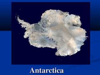
an average of only 166 mm of precipitation per year. Population of Antarctica The number of people conducting and supporting scientific research. The number of people varies about 1,000 humans in winter and to about 5,000 humans un the summer. Many of the stations are staffed yearround, the overwintering personnel typically arriving from their home countries for a oneyear assignment. Emilio Marcos Palma was thr first person born on the Antarctic mainland in 1978. Geography of Antarctica Antarctica is divided in two by the Transantarctic Mountains close to the neck between the Ross Sea and the Weddell Sea. The three largest mountain ranges on the Antarctic continent are the Transantarctic Mountains, the West Antarctica Ranges, and the East Antarctica Ranges. Vinsin Massif is the highest peak in Antarctica at 4,892 m. Thank you for listening
landmass, an array of extraordinary animals and plants have also flourished, such as tree kangaroos and birds of paradise. Close to 10% of the world's vertebrates are concentrated here, while 7% of the world's higher (vascular) plants grow on the island's productive soils. 3 Geography Papua New Guinea consists of over 600 islands and lies in the middle of the long chain of islands stretching from mainland South-East Asia. The mainland and larger islands are mountainous and rugged, divided by large fertile upland valleys. Fast- flowing rivers from the highlands descend to the coastal plains. A line of active volcanoes stretches along the north coast of the mainland and continues on the island of New Britain. To the north and south of this central mountain range on the main island lie vast stretches of mangrove swamps and coastal river deltas. /1/ Volcanoes and thermal pools are also found in the southeast of other islands
Fourth level Fifth level foreign born v Since 1945 more than six million people from across the world have come to Australia to live GEOGRAPHY v Sixth largest country in the world v Australia's coastline stretches almost 50,000 kilometres and is linked by over 10,000 beaches v The mainland is the largest island and the world's smallest, flattest continent v Australia is located between the Indian and South Pacific Oceans PLACES WHERE I WENT IN AUS Click to edit Master text style v PERTH Second level Third level ALBANY v Fourth level v ESPERANCE
Home to numerous birds and animals . Rich variety of fauna . There are permanent communities of bear, wolf and lynx in the park so keep your camera on standby . It's also home to ... migratory waterfowl ...and swans . In this Park you will see the deep dark pine (mänd) forest . Hiiumaa The second largest island (989 km²) . It is located in the Baltic Sea . The largest town is Kärdla . Hiiumaa is the main island of Hiiu County . Transport From Estonian mainland to Hiiumaa involves a 90minute (28 km) ferry crossing from Rohuküla to Heltermaa . There are about 10 ferry departures a day. In the summer weekends, getting car space on the ferry usually requires advance booking. There are about 2 scheduled buses a day between Tallinn and Kärdla . Hiiumaa is served by Kärdla Airport, with regular flights to Tallinn . Bicycle rental is available in Kärdla and there is a good bicycle path built from Kärdla towards Kõrgessaare . Some pictures ...
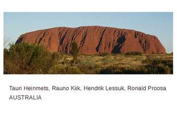
Tauri Heinmets, Rauno Kiik, Hendrik Lessuk, Ronald Proosa AUSTRALIA Geographical position Australia is a country in the Southern Hemisphere comprising the mainland of the Australian continent as well as the island of Tasmania and numerous smaller islands in the Indian and Pacific Oceans. world's sixth-largest country by total area. The lowest point in the country is lake of Eyre (15m below sea level) and the highest point is Mount Kosciuszko (2229m) Economy Mixed economic system Division of labor Agriculture 3,6%; Industry 21,1%; Tendance 75% Units of labor 11,45 mlj. 2009. Unemployment 5,6% Most important export articles: coal, iron,gold
Britain forms the greater part of the British Isles, which lie off the north-west coast of mainland Europe.The geographical name for all the islands is the British Isles. They also include Eire, the Republic of Ireland, which has been politically independent of the British government since 1921. The largest of the islands is called Great Britain and it comprises England, Wales, snd Scotland. The full political name for the countries sharing a parliament in London is the United Kingdom of Great Britain and Northern Ireland. Covering an area of some 242, 500 sq km. The longest river,
talks about the creation of the new nation were taking place in the different colonies. This is the national anthem of Australia. Australia's national emblems Floral - Sturt's Desert Rose Colours - Black, white, and ochre Bird - Wedge-tailed Eagle Animal - Red Kangaroo Australia's states and territories Australia has six states: New South Wales, Queensland, South Australia, Tasmania, Victoria, and Western Australia. Two major mainland territories: the Northern Territory and the Australian Capital Territory Australia's largest cities Sydney, Melbourn, Adelaide, Perth, Darwin, Brisbane, Canberra(capital of Australia) Australia's politics The federal government is separated into three branches: The legislature: the bicameral Parliament, comprising the Queen (represented by the Governor-General), the Senate, and the House of Representatives;
The united kingdom · Britain includes all the islands the republic of ireland, northern ireland, scotland, wales and england, which lie off the north-west coast of mainland europe. · Great britain comprises england, wales and scotland. The full name is the united kingdom · Covering 242,500 sq km, britain nearly 500 kmwide and almost 1,000 km long. The climate is tempererate but subject to frequent changes. Wettest areas- north and west, the warmest- south-east. Longest river, the severn, flows for 354 km and the largest lake is lough neagh 388 sq km. Scotland is the most mountainous part and the highest
The united kingdom · Britain includes all the islands the republic of ireland, northern ireland, scotland, wales and england, which lie off the north-west coast of mainland europe. · Great britain comprises england, wales and scotland. The full name is the united kingdom · Covering 242,500 sq km, britain nearly 500 kmwide and almost 1,000 km long. The climate is tempererate but subject to frequent changes. Wettest areas- north and west, the warmest- south-east. Longest river, the severn, flows for 354 km and the largest lake is lough neagh 388 sq km. Scotland is the most mountainous part and the highest
Estonia Estonia is a little country in Northen Europe. Estonia is borderd by the Baltic Sea and Gulf of Finland, it's between Latvia and Russia. Its geographic coordinates are 59 North 26 Eeast. Estonias capital is Tallin, it is situated in the North of Estonia. Estonias mainland terrain is flat, boggy, and partly wooded, offshore lie more than 1,500 islands. From the north flat and from the east is Estonia hilly. It's highest peak is Suur Munamägi(318 m). Sometimes flooding occurs in the spring in Estonia. It's biggest lakes are Lake Peipsi and Lake Võrtsjärv. It's biggest islands are Saaremaa and Hiiumaa. In Estonia there is 26.5% arable land, 0.35% permanent crops and 73.15% other land. Natural
extinct species and subspecies. b) The rarest animal on Earth today is the Pinta Island Tortoise (originating from the Galapagos Islands) , which is critically endangered, since there is only one remaining in existence. Tortoises on the Galápagos have been hunted for their meat by sailors and fishermen to the point of extinction. Also, the habitat of the tortoises has been eaten away by goats introduced from the mainland. There have been several attempts to breed the last representative of the species with similar tortoise varieties, but none of the eggs hatched. On the other hand, there is hope for the successful conservation of rare animals. A number of different international organisations have the same goal and work hard to protect both endangered wildlife and natural habitats. a) The World Wildlife Fund (WWF) has been protecting nature for already more than 45 years
v The Atlantic Ocean v The Celtic Sea The Irish Sea v Separates the islands of Ireland and Great Britain v St George's Channel and the North Channel v Whales and dolphins v Radioactively contaminated sea The Irish Sea v Regional trade, shipping, transport, fishing and wind power v Twenty-one species of seabirds The Irish sea v Ireland has no tunnel or bridge connection to mainland Europe v Some cities around the Irish sea: Dublin, Liverpool, Blackpool, Southport, Brikenhead, Bray, Wexford, Larne, Belfast. v The sea is main way of shipping goods The Atlantic ocean v Is the second largest ocean in the world v The North Atlantic Ocean and the South Atlantic Ocean v Connected to the Arctic Ocean, to the Pacific Ocean, the Indian Ocean and the Southern Ocean The Atlantic Ocean v
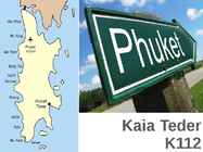
Kaia Teder K112 About One of the southern provinces of Thailand The island is connected to mainland Thailand by two bridges Country : Thailand Capital : Phuket City Area : 576.0 km2 Population : 600,000 (2013) The relatively recent name "Phuket" is apparently derived from the word bukit which means "hill", as this is what the island appears like from a distance. The symbol is a picture of Thao thep kasatri and Thao sri sunthon Heroines Monument. The reason for the use of the pictures of these heroines is because they protected the province from the Burmese in 1785 AD. Attractions
The parliament consists the Senate and the House of the Reprentativer. The head of the government is the prime minister. The Prime Minister is elected by the House of Representatives and the Cabinet. The Prime Minister is John Howard. Currency- Australian dollar. Relief Australia has a variety of landscapes. The Great Australian Bight lies in the south of Australia. The Gulf of Carpentaria is between the Arafura Sea and Cape York. The Bass Strait separates the island of Tasmania from the mainland of Australia. The Great Barrier Reef is in the north-east of Australia, between the Coral Sea and the mainland. The western part of Australia is covered with deserts. Most of the rocks have turned into sand. The biggest of them is the Great Sandy Desert, which lies in the north of Western Australia. The Gibson Desert is in the middle of Western Australia. The Victoria Desert is in the south of Western and South Australia. The Tanami Desert is in the west of the Northern Territory.
Monetary unit is Australian dollar. Their national holiday is on the 26th of January. In 1788 on the 26th of January the first fleet arrived at Botany Bay and established a penal colony near modern-day Sydney. Geographical Position Australia is located in the Southern Hemisphere. It’s the only continent except for Antarctica that is all south of equator. Sometimes Australia is called the island continent. There is a great reason why. It really is an island. It is 2880 km from the mainland of Asia and is almost half way round the world from Europe. More than 9 600 km separates it from America. Australia lies between the Pacific and Indian oceans. The Timor Sea and the Arafura Sea separate Australia from Indonesia. In the north the coast is washed by Great Australian Bight and the Indian Ocean. In the northeast the Coral Sea washes the coasts and in the southeast there is the Tasman Sea which also separates Australia from New Zealand.
Today the Prime Minister is John Howard, the leader of the Liberal Party. History Australia was once a part of the giant continent Gondwana. It included Africa, South America and Antarctica. First Australia and Antarctica split from Gondwana, then Australia broke away from Antarctica and began to move north. Aborigines arrived there about 50 000 years ago. They had occupied the whole continent by 30 000 years ago. At that time Tasmania was still part of the mainland. About 20 000 years ago the ice began to melt and the rising water level cut Tasmania off from the mainland. Traders from what is now Indonesia are thought to have been visiting Australia well before the 17th century. Chinese, Malaysian and Arab sea Captains may also have landed in Northern Australia after the 15 th century. Still Australia remained unexplored until 17th century. One reasons Australia remained undiscovered was that it was located off the trading corridor of the
Scotland ! Scotland (Gaelic: Alba) is a country in northwest Europe that occupies the northern third of the island of Great Britain. It is part of the United Kingdom, and shares a land border to the south with England. It is bounded by the North Sea to the east, the Atlantic Ocean to the north and west, and the North Channel and Irish Sea to the southwest. In addition to the mainland, Scotland consists of over 790 islands including the Northern Isles and the Hebrides. Edinburgh, the country's capital and second largest city, is one of Europe's largest financial centres. It was the hub of the Scottish Enlightenment of the 18th century, which saw Scotland become one of the commercial, intellectual and industrial powerhouses of Europe. Scotland's largest city is Glasgow, which was once one of the
The United Kingdom The United Kingdom consists of England, Scotland, Wales and North Ireland and it is situated in the Atlantic Ocean near the mainland of Europe. The population of the UK is 58.6 million and area is 244,110 sq km. Britain has a temperate humid climate. Its characteristic features are mild winters, warm summer, no temperature extremes, abundant rain all year round and frequent changes of weather. The mild climate is partly due to the warm Gulf Stream and partly to the south westerly winds. Occasional winds from the east in winter may bring cold and dry weather
Ireland (or short United Kingdom)' The population is about 60.4 million. The capital is London. Other biggest cities include Birmingham, Bristol, Portsmouth, Glasgow and Swansea. English is the main language of Great Britain, but Welsh is officially recognized in Wales and Gaelic in Scotland. 2. Geographical position The British Isles is the geographical term for a group of about 5000 islands off the coast of mainland Europe. The largest island is Great Britain, which is also the largest island in Europe. It consists of England, Wales and Scotland. The next largest island is Ireland, which is made up of Northern Ireland and the Irish Republic. Britain and Northern Island together form the United Kingdom. When referring to Britain or Great Britain in everyday life, the names are used to mean the United Kingdom. The English Channel (and best known: the Strait of Dover) separate Britain from
OVERVIEW The largest of the world's five Mediterranean-climate regions, the Mediterranean Basin stretches west to east from Portugal to Jordan and north to south from northern Italy to Morocco. Surrounding the Mediterranean Sea, the hotspot's 2,085,292 km² also include parts of Spain, France, the Balkan states, Greece, Turkey, Syria, Lebanon, Israel, Egypt, Libya, Tunisia and Algeria, as well as around five thousand islands scattered around the Mediterranean Sea. West of the mainland, the hotspot includes the Macaronesian Islands of the Canaries, Madeira, the Selvages (Selvagens), the Azores, and Cape Verde. The basin's location at the intersection of two major landmasses, Eurasia and Africa, has contributed to its high diversity and spectacular scenery. The region boasts mountains as high as 4,500 meters, peninsulas, and one of the largest archipelagos in the world.
5 persons per sq.km. There are 10 provinces and 3 territories. The biggest provinces are Alberta, British Columbia and Manitoba. The biggest city is Montreal with 3.8 million people. The capital Ottowa has only 1.2 million people and is listed fourth biggest city. 32% of population is Canadian, 21% is English and 15.8% is French. First Nationist are only 4%. 80% of Canadians live in 3 urban areas concentrated in the Quebec City- Windsor Corridor, the British Columbia Lower Mainland, and the Calgary-Edmonton Corridor. 80% of the population live within 150km of the US border; 90% lives within 300km of the US border. Most First Nations live in reservations in the southern part of the country. If you look at the map of the world, you will notice what a huge country Canada is. It is the second largest country in the world, xceeded only by Russia. From St. John`s to Victoria Canada stretches about 7000km. In fact, Canada`s east coast is closer to Europe than it is to Canada`s
In fact I think it's a plus to Estonia as they will be always ready to defence their freedom with belief that they know what they are doing. Australia, being the world smallest continent but the world sixth-largest country by total area, with its 7.741.220 square kilometres land has only 24 million people. The geography of the country is extremely diverse, ranging from the snow-capped mountains of the Australian Alps to large deserts, tropical and temperate forest. 70% of the Australian mainland is classified as desert which is mainly located in the centre of Australia what explains now the population. When you visit Australia, there aren't many expressions you'll hear more often than "no worries, mate".They are very laid-back, irreverent, funny and happy people. Maybe it's all the sunshine, the miles of beaches, or the pristine nature, or the excellent quality of life but nothing seems to worry them. Australians always greet people with the proverbial "how are you
Portugal ABOUT Photo Location of Portugal (dark green) Portugal (Portuguese: Portugal, IPA: [putua]; officially the Portuguese Republic, Portuguese: República Portuguesa) is a country located in Southwestern Europe, on the Iberian Peninsula. It is the westernmost country of mainland Europe, and is bordered by the Atlantic Ocean to the west and south and by Spain to the north and east. The Atlantic archipelagos of the Azores and Madeira are Portuguese territory as well. The country is named after its second largest city, Porto, whose Latin name was Portus Cale. SETTLEMENT
Australia. Kadri Rampe 2012 Position in the world. Australia, officially the Commonwealth of Australia, is a country comprising the mainland of the Australia continent, the island of Tasmania and numerous smaller islands. Its the world`s sixthlargest country by total area. On 1 January 1901, the six colonies federated,forming a Commonwealth of Australia, since Federation, Australia has maintaned a stable liberal democratic political system. The population of 22,7 million is highly urbanised and heavily concentrated in eastern states due to geography and climate. A highly developed country, Australia is the world's 12th
Most of the island's previously numerous Swedish speaking population emigrated or were "Estonia" during the period of Imperial Russian rule, although a small minority remains to this day. Estonian Swedes are also known as "aibofolke" (meaning island people in Swedish) or "rannarootslased" (meaning coastal Swedes in Estonian). Transport Road transport from Estonian mainland to Hiiumaa involves a 90-minute (28 km) ferry crossing from Rohuküla to Heltermaa, which is 25 km by road from Kärdla. There are about 10 ferry departures a day. In the summer weekends, getting car space on the ferry usually requires advance booking. There are about 2 scheduled buses a day between Tallinn (the capital of Estonia) and Kärdla. In the winter, the island can be reached, conditions permitting, via a 26.5 km ice road (the longest in Europe) across the frozen Baltic Sea.
Of- fraasid: the Tower of London the Houses of Parliament the Isle of Man the north of France Geograafilised piirkonnad: the mainland the Antarctic the North of Germany the Midwest NB! geograaf. nimed, mis koosnevad pärisnimest ja täiendist, on ilma artiklita: Northern Ireland South-Estonia
11241153), who built it as a private chapel for the royal family and dedicated it to his mother, Saint Margaret of Scotland, who died in the castle in 1093. The castle has sheltered many Scottish monarchs. They include Queen Margaret (later St Margaret), who died here in 1093, and Mary Queen of Scots, who gave birth to James VI in the Royal Palace in 1566. Eilean Donan Eilean Donan is a small island in Loch Duich in the western Highlands of Scotland. Connected to the mainland by a footbridge, the island is dominated by a picturesque medieval castle. The original castle was built in the early 13th century as a defense against the Vikings. Today, the castle is one of the most photographed monuments in Scotland and a popular venue for weddings and film locations. Loch Ness One of the most famous lakes in the world, Loch Ness is the second largest loch in Scotland after Loch Lomond. About a mile wide at most places it holds the legend of an infamous sea monster
The Great Basin Desert is the largest desert in America. Missouri river is the longest river in the States. The largest lake is Lake Superior. Click to edit Master text styles Second level Third level Fourth level Fifth level There are very many species in the States. There are about 17 000 types of trees (larger plants) in the mainland and Alaska. Over 1,800 species of flowering plants are found in Hawaii. The United States is home to more than 400 mammal, 750 bird, and 500 reptile species. About 91,000 insect species have been described. In America, there are very many parks, which 58 are national parks and there are hundreds of federally managed parks, forests and wilderness areas. The first national park in the world was Yellowstone national park in Wyoming. http://www.youtube.com/watch?v=3iaSlZE-Wxs&feature=related
the local government's autonomy. The arrival of democracy in the late 1970s led to the Statute of Autonomy of the Balearic Islands. Today the island is part of the Balearic Autonomous Community, along with Majorca, Minorca and Forment History During the Second Punic War, the island was assaulted by the two Scipio brothers in 209 BC but remained loyal to Carthage. With Carthaginian military luck running out on the Iberian mainland, Ibiza was last used by the fleeing Carthaginian General Mago to gather supplies and men before sailing to Minorca and then to Liguria. Ibiza negotiated a favorable treaty with the Romans, which spared Ibiza from further destruction and allowed it to continue its Carthaginian-Punic institutions well into the Empire days, when it became an official Roman municipality. For this reason, Ibiza today offers excellent examples of late Carthaginian-Punic civilization. During the Roman Empire,
Guyana Guyana is officially named the Co-operative Republic of Guyana and it is in South America. Its capital is a Georgetown and presdient Bharrat Jagdeo. The population is about 738,000. Guyana is bordered to the east by Suriname, to the south and southwest by Brazil and to the west by Venezuela. It is the third smallest country on the mainland of South America. Culturally it is more associated with the Caribbean than with Latin America and is the only English speaking country in South America. Guyana is an Amerindian word meaning "Land of many waters" beacause of its rain forests dissected by numerous rivers, creeks and waterfalls, including the famous Kaieteur Falls. The country enjoys a diverse, multicultural society, high floral and faunal biodiversity, prize-winning rum, and Demerara sugar
whole area. Today the area of the former City of Halifax is now referred to as an unincorporated "provincial metropolitan area" by the provincial government's place name website[3] and the area is referred to as "Halifax, Nova Scotia" for civic addressing and as a placename.The area is now administered as two separate community planning areas by the regional government for development, Halifax Peninsula and Mainland Halifax. It forms a significant part of the Halifax urban area. Residents of the former city are referred to as "Haligonians Halifax Calgary is the largest city in the Province of Alberta, Canada. It is located in the south of the province, in an area of foothills and high plains, approximately 80 km (50 mi) east of the front ranges of the Canadian Rockies. The city is located in the Grassland region of Alberta.
Estonia, but of all the Baltic countries. The country has 3974 km of coastline, while the land border, in comparison, is only a mere 633 km. The coast varies from limestone cliff in the north to sandy beaches in the west. Most of Estonia's many islands belong to the West Estonian archipelago. The largest islands are Saaremaa with 2671 sq km, Hiiumaa with 989 sq km and Muhu with 200 sq km. The sea between these islands and the Mainland Väinameri is very shallow (less than five metres deep on average) and rich in shoals. The water of the Baltic Sea is brackish. Its average saltinity is only one fourth of that of the sea in general. Thus, most Estonian freshwater fish (about 30 species) also inhabit the sea. There are some 1450 lakes in Estonia (6.1% of its territory). The two largest of them are Lake Peipsi (the fifth largest in Europe) at 3555 sq km and Võrtsjärv with its 270 sq km area.
Georgiu was happy, because her both daughters had a man with position. Wedding-day was planned. But suddenly Maria discoverd some leprosy signs on her leg and wedding was cancelled. Maria went to Spinalonga. Soon she met there a doctor, named Kyrtis. They both felt something for each other. At that time, when Maria was on an island, doctors had invented a medical remedy, what could cure leprosy. They were experimenting this on patients who were quite healty. It worked. Soon people went back to mainland when premisson came from government.. Some people didn't like idea of going home, because they had used with that life on the island. Expecially older people. When Maria was back home, Dr Kyrtis asked Maria to marry him, but Maria refused. Her sister, Anna had just died. Anna's husband Andreas shot him, because he found out that Anna had a love-afair with Manoli many years. After some years, dr Kyrtis returned to Planka and asked again Maria to marry him