Leidsid 33 sarnast õppematerjali, mis on seotud failiga "Estonia traditional costumes". Need materjalid aitavad sul teemat sügavamalt mõista.
women, wool, north, region, south, wore, tradition, colour, traditional, mainly, dress, century, cloth, skirt, shirt, linen, shirts, wear, similar, coat, island, costumes, 19th, garments, brown, indigo, first, west, setu, suit, caps, northern, stocking, social, former, today, fabric, married, while, outer, black, widely, 18th, among, regions, islandsArchitecture Early Anglo-Saxon buildings in Britain were generally simple, constructed mainly using timber with thatch for roofing. The Anglo-Saxons built small towns near their centres of agriculture. In each town, a main hall was in the centre. The architectural character of Anglo- Saxon ecclesiastical buildings range from Coptic influenced architecture in the early period; basilica influenced Romanesque architecture; and in the later Anglo-Saxon period, an architecture characterised by pilaster-strips, blank arcading, baluster shafts and triangular headed openings.
NAVAJO PEOPLE CLOTHING Clothing · Navajo clothing for both men and women initially was deerskin for shirts and skirts. · The men later wore cotton or velvet shirts with no collars, breeches below the knee, and moccasins. · Women gradually wore the "squaw dress," made of plain dark blankets Men · After the 1800's the Navajo men borrowed the style of the Mexicans and wore blankets draped over one shoulder. Their pants ended halfway between their knees and ankles. They decorated the seams of their pants with silver buttons. Men · Primitively the men dressed in deerskin shirts, hip-leggings, moccasins, and native blankets. These were superseded by what has been the more universal costume during the present generation: close-fitting cotton or velvet shirt, without collar, cut rather low about the neck and left open under the arms. Men
money and a room of her own if she is to write fiction. Simone de Beauvoir most wellknown feminist. bell hooks multiplicity of experience, sex(male/female) vs gender(social/construct) Judith Butler performativity – gender is performed. Bloomsbury Group modernists (max 10 ppl) 5. Feminism and women’s roles during the Victorian Era. How were women disadvantages during this period? Some laws that helped changed the status of women. Women’s rights were extremely limited in this era, losing ownership of their wages, all of their physical property, excluding land property, and all other cash they generated once married. 1857: violence recognized as grounds for divorce 1870: women could keep money they earned
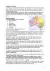
Setomaa The extreme south-eastern corner of Estonia - this is the location of SETOMAA, a peculiar historical and ethnical province in Estonia. Setomaa is bounded in the north-east by Lake Pihkva, in the east and south-east by Russia, in the south by Latvia and in the west by Võru County. The greatest extent from north to south is 65 km and from east to west 40 km. Today Setomaa is divided between three administrative units: Võru and Põlva counties of Estonia and Pechorsky district of Russia. On the territory of Estonia, Setomaa comprises four municipalities: Misso, Meremäe, Värska and Mikitamäe municipalities. According to the latest archaeological finds the area of Setomaa has been inhabited for as long as 8 400 years.The ancestors of the people speaking the Võro-Seto dialect belonged to the Balto-Finnic
The Wichita Tribe Anett Roosa Kärdla School 9A Wichita Tribe Were original people of southern Oklahoma and northern Texas, but after Europeans arrived, population pressures forced them further north into Kansas, where the city of Wichita is named for them. Most Wichita people are living in Oklahoma today. Speak English today. Some also speak their native Wichita language The Wichita Nation has its own government, laws, police, and services Before becoming a civilization, they tattooed their faces, arms, and chests. They were a steadfast and peaceful people. They had about 500 warriors in their tribe
Although jealously guarding their privileges, the knighthoods still never became entirely closed. Between sessions of a Diet, the legislative power of the knighthoods belonged to the Council of the Diet. The towns were governed by the Town Councils, which supplemented their ranks from among the representatives of merchants and lawyers. The citizens and the inhabitants of a town did not coincide -- most of the population had no civic rights. The lower class mainly consisted of Estonians. While an special status secured the supremacy of the Baltic knighthood and the German upper classes in towns, it considerably aggravated the legal and social situation of Estonians. It can be said that the pre-nationhood Landesstaat, with its strict social structure, effectively prevented Estonians from becoming Germans. Considering their relatively small number, the beneficiaries of the Landesstaat were
Tallinn English College Topic Estonia Tallinn 2008 1. Introduction Estonia is a small country about the size of Switzerland, or New Hampshire and Massachussetts combined. Estonia is named after the people called "Ests" who lived in the region in the 1 st century AD. The Republic of Estonia is one of the three countries commonly known as the "Baltic States". The other Baltic States are Latvia and Lithuania. 2. Geographical position Estonia is situated in northeastern Europe. Estonia is bounded on the north by the Gulf of Finland, on the east by Russia, on the south by Latvia and on the west by the Baltic Sea. In the north it borders on Finland. The coastline of the Baltic
In 2007 more than a hundred performers appeared at more than ten stages. The selection of music varies from jazz to rock and disco. It is a great Estonian party which cannot be found anywhere else in the world. Estonian Song Festival (Laulupidu) The AllEstonian Song Festival (Laulupidu) happens in Tallinn every five years, and gives a privileged insight into Estonian music and culture. Its aim is to bring together all the traditional songs and singers from across the country, as well as guest singers from other countries. The first AllEstonian Song Festival was held in 1869 in the town of Tartu , near the centre of Estonia. Around 870 singers took part, along with 76 musicians. Things have changed a lot, and today, the average festival gathering involves 25,000
The current coat of arms of Estonia is a golden shield which includes three slim, blue leopards (or lions) in the middle, with oak branches along the side of the shield. It originates from Denmark. It was officially adopted in 1925. Geography Estonia is the northernmost of the three Baltic States. It is located on the northern hemisphere on the eastern shores of the Baltic Sea in the north-east of Europe. It has land contact with Russia from the east and Latvia from the south. In the north The Gulf of Finland separates Estonia from Finland. The Gulf of Riga is situated to the south-west. Estonia has more than 1500 islands. The biggest ones are located to the west. The four biggest islands are Saaremaa, Hiiumaa, Vormsi and Muhu. The highest point in Estonia and also in the Baltic region is Suur Munamägi. It is 318. above sea level. Estonia is a country of a thousand lakes. The Largest one is Lake Peipsi which is also the fourth biggest freshwater lake in Europe
during the Soviet military coup attempt in Russia and the following collapse of the Soviet Union. The first country to diplomatically recognize Estonia's reclaimed independence was Iceland closely followed by Denmark. The last Russian troops left on August 31, 1994, and Estonia joined NATO on March 29, 2004 and the European Union on May 1, 2004. Karksi - Nuia Karksi Nuia is small town located in south of Viljandimaa. It has population of 2200 people. In Karksi Nuia is on gymnasium , kindergarten, few shops and big cultural centre. In culture centre there are café, library, parish government etc. There take places acting lessons, theatres, parties and other activities. There is music school also. This is for children's, but older people can learn there too. Karksi Nuia has many interesting places to visit and look. One of them is Maies farm, few kilometers from city centre.
and take her out, but they were always chaperoned. A few days before the wedding, the young man gave his fiancée a wedding basket with lacework (handkerchiefs, mantilla, fan), a cashmere shawl, gloves, and jewelry. She could not wear the jewelry before the wedding, nor could she leave the house for three days before the wedding. 4 The Creoles liked to have weddings on Mondays or Tuesdays in Saint Louie Cathedral in New Orleans in the late afternoon. The bride wore a silk dress with pearls and lace. The veil was held in place with a crown of orange blossoms. The bride carried the same flowers in her bouquet. Later she left the bouquet in the church, put it on a relative's grave, or sent it to the convent where she studied. After the ceremony the members of the family signed the register. The guests then went to the bride's home for the banquet. The bride cut the cake and gave pieces of it to single girls to put under their pillows
wonderful medieval Old Town where the atmosphere of the 15th and 15th centuries can still be strongly felt. Its narrow cobbled streets, medieval buildings with various decorative elements, attractive weather-vanes and soaring spires are very special and draw visitors in large numbers. Only a few town in northern Europe have medieval districts as well preserved as in Tallinn. It was included in the UNESCO World Heritage List in 1997. The rest of the capital could be called the New Town, dating mainly from the 19th and 20th centuries. Tallinn is a mixture of the modern and the medieval where tradition goes hand in hand with the most recent trends. Its cross-cultural history has given the city a special charm. It has about 30 museums, 25 galleries and 15 exhibition halls. Among its many twin towns and partners are Helsinki in Finland, Schwerin and Kiel in Germany, Stockholm and Malmö in Sweden, Gent in Belgium, Venice in Italy and Odessa in the Ukraine.
Estonia. Estonia, officially the Republic of Estonia is a country in Northern Europe. It is the smallest of the three Baltic countries. Estonia has land borders with Latvia (339 km) to the south and Russia (229 km) to the east. It is separated from Finland in the north by the narrow Gulf of Finland and from Sweden in the west by the Baltic Sea. Estonia has been a member of the European Union since May 1, 2004 and of the NATO since March 29, 2004. The area of Estonia is about 45000 square kilometres and the population is about 1.4 million people. The capital of Estonia is Tallinn and the official language is Estonian. The currency is Eesti kroon. The main religion is Lutheran. Anniversary of the republic is celebrated on February 20
Estonia Estonia is a small country in Northern Europe with an area of about 45 000 sq km. As a part of the East-European Plain, the country has a rather flat surface. The highest and most diverse region in Estonia is in the south-eastern part of the country. At 318 metres, Suur Munamägi is not only the highest point in Estonia, but of all the Baltic countries. There are about 1500 islands in Estonia, the biggest of which being Saaremaa and Hiiumaa. Sixty-four species of mammals have been recorded in Estonia, three of them have been introduced: the racoon dog, the American mink and the muskrat. A couple of species have
FACTFILE Area: 45 228 sq km Poplulation: under 1.4 million Capital: Tallinn Language: Estonian Currency: Eesti kroon (EEK) Main religion: Lutheran National holiday: 24 February (anniversary of the republic) National flower: Cornflower National bird: Barn Swallow National stone: Limestone LOCATION The Republic of Estonia is the northernmost and smallest of the three Baltic States. It is located on the eastern shores of the Baltic Sea in the north east of Europe. To the east the country borders Russia. Latvia is the countries neighbour to the south. From the west the coast of Estonia is washed by the Baltic Sea and from the north by the Gulf of Finland. The length of the coastline is approximately 3 800 km. The longest distance from east to west is 350 km, while north to south Estonia stretches 240 km. THE NAME The name EESTI was apparently derived from the word AISTI, the
My Town I live in Tallinn. It's the capital and main seaport of Estonia. Tallinn is a very beautiful city that lies on the Baltic Sea. It covers 158 square kilometres. The Mayor of Tallinn is Jüri Ratas. The population of our capital is about 400000 people. About 55% of them are Estonian, 37% Russians and the other 8% are from different nations. The people here are mostly engaged in industry- mainly the food industry (23%), trade (16%) and transport and communication (14%). History. Tallinn has a great history. It was first marked on a map of the world by the Arab geographer al-Idrisi in 1154, its name then being Kolyvan. In the 13 th- century chronicle of Henricus de Lettis the town was called Lyndanise. Then it was called Reval for some time and finally Estonians started to call the town Tallinn from Taanilinn (Danish town) after the Danish conquest in the 13th century.
CANADA REVISION QUESTIONS 2010 1. The main physiographic regions of Canada. Canada may be divided into seven physiographic regions: Arctic Lowlands, Cordilleran Region, Interior Plains, Hudson Bay Lowlands, Canadian Shield (Forest Lands), St Lawrence Lowlands and Appalachian Region. Divisions are based on each area's relatively similar physical geography and landforms. Physiographic regionalization is defined here as the process by which regions with relatively homogeneous physical geography are determined 2. Who are the native people of Canada? Into which three groups can they be divided? Canada's constitution specifies three categories of aboriginal peoples: Indian (First Nations), Métis, Inuit. According to Canadian census 2011, 1
The UK contains a number of small islands. The largest islands that belong to the United Kingdom are the Isle of Man in the Irish Sea and the Isle of Wight which lies off of England's southern coast. The largest groups of islands are the Shetland Islands, the Orkney Islands and the Hebrides. Geographical Position The UK is situated in the Northern Hemisphere. The United Kingdom is bordered by the Atlantic Ocean in the west, the North Sea in the east, the Norwegian Sea in the north, and the English Channel, also known as La Manche, in the south and it also separates the country from the continent of Europe. The neighbours of the United Kingdom are Iceland in the north-west, Norway in the east and France in the south. Britain also has many dependant territories which are scattered throughout the world and are the remains of the huge former British Empire. Today Britain assists them, but they may become independent whenever they wish
festivals take place in Tallinn. The yachting regatta of the 1980 Moscow Olympic Games was held at Pirita. History Tallinn means in English "Danish town". The place is believed to have been settled by Finno-Ugric people about 2500 BC. It was first marked on a map of the world by the Arab geographer al-Idrisi in 1154. The Estonians were the first to build a stronghold on the spot of the Toompea Hill, but the real Tallinn was built by the Danes who conquered the north of Estonia in 1219. Legend has it that one day, when the Danes were about to lose a bloody battle, the sky suddenly opened and a red flag with a white cross on it dropped down upon them from the heaven. This is how the Danes obtained their national flag. In 1346 the Danish king sold his Estonian lands to the Teutonic Order, who a year later resold them to the Livonian Order. The Germans renamed Tallinn and called it Reval. Toompea became the seat of the German-born gentry
anyone to leave the Soviet Union. The major group of post-Soviet immigrants were the political refugees, persons who claim persecution or reasonable fear of persecution in Russia. Largest Russian communities today are in New York, California and Florida. 5. From where did the Indians come to America? *Native Americans aka. Indians, Red Indians, Redskins, American Indians, Amerindians, Namerind, First Nations people (Canada) *Origins of N-Am, theories = Bering Land Bridge theory = North American Indians are the people whose ancestors were living in North America when the Europeans discovered the Western Hemisphere. They often are called red men, or redskins, and they were named Indians because Columbus thought that he had reached the East Indies in his voyage across the Atlantic. Stone-age people who were to become American Indians began entering America at least 10,000 years ago. Most experts believe the first Indian ancestors arrived 30,000 or more years ago
written in 1814 by Francis Scott Key. There are 6 time zones. From east to west they are: Eastern Standard Time, which is 5 hours behind Greenwich Time, Central Standard Time, Mountain Standard Time, which is 7 hours behind Greenwich Time, Pacific Standard Time. Alaska and Hawaii have their own time zones: Alaska Standard Time and Hawaii Standard Time. Geographical Position The USA lies in the Northern Hemisphere in North America. It covers a big part of the continent and is also the third largest country in the world. The country consists of 50 states, but two of them lie separately. One of them is Alaska, which is near the Arctic Circle. And the other state is Hawaii, which is a group of island is the Pacific Ocean. The USA shares the border with Canada in the north and Mexico in the south. In the east the coast is washed by the Atlantic Ocean and in the west by the Pacific Ocean
If you want to make clear that you are speaking about the country, you may call it the Commonwealth of Australia. It’s the official name of the country. Australia is the smallest continent, but one of the largest countries on Earth. It’s 6th largest country. Its area is about 7.6 million sq km. One third of it is occupied by deserts. It’s both the flattest and, except for Antarctica the driest. Neighbouring countries include Indonesia, East Timor and Papua New Guinea in the north, the Solomon Islands, Vanuatu in the northeast, and New Zealand in the southeast. Its capital is Canberra. Other big cities are Melbourne, Sydney, and Brisbane. National language in Australia is English. Monetary unit is Australian dollar. Their national holiday is on the 26th of January. In 1788 on the 26th of January the first fleet arrived at Botany Bay and established a penal colony near modern-day Sydney. Geographical Position Australia is located in the Southern Hemisphere. It’s the
The capital city is Washington D.C. Although the United States has no official language at the federal level, English is the de facto national language. English is the most common language for daily interaction among both native and non-native speakers. Spanish is the second language. The largest city is the New York City. The Government is Federal constitutional republic and the president is George W. Bush. 2. Geographical position The United States of America is located on the continent of North America. It has borders with two countries Mexico and Canada. There are also the Atlantic Ocean, the Pacific Ocean and the Gulf of Mexico surrounding the big country. There are 50 states in America. Most of the people live in towns. The biggest state is Alaska; next by size are California, Alaska and Montana. Six states - Maine, Vermont, New Hampshire, Connecticut, Rhode Island and Massachusetts are called New England. They are all small states in the USA that lie in the north- east
Introduction, Location Australia is a country between the Indian Ocean and the Pacific Ocean. It is the only country in the world that occupies an entire continent. The mainland covers an area of 7.7 million km² and it is about 3700 km from the most northern point to its most southern point and about 4000 km from east to west. There are also many different seas around Australia, like the Coral and the Tasman Seas in the west or the Timor and the Arafura Seas in the north, where the Indian and the Pacific Oceans meet. Because all seas and oceans near Australia are warm, surfing is a very popular hobby. Political subdivision Australia is divided into six states, which are: · New South Wales · Victoria · Queensland · South Australia · Western Australia · Tasmania New South Wales is the most populous state in Australia. Its capital is Sydney. Victoria is one of the most densely populated states in Australia. Its capital city is Melbourne
approximately 350-400 million native speakers. Which place does English occupy in the world by its number of speakers?After which language? English occupies second place by its number of speakers after Mandarin Chinese. 3. What is the difference between English as a Second Language, English as a Foreign Language and English for Specific Purposes? Give examples of situations where they are used. English as a Second Language (ESL or TESL) is a traditional term for the use or study of the English language by non-native speakers in an English-speaking environment. That environment may be a country in which English is the mother tongue (e.g., Australia, the U.S.) or one in which English has an established role (e.g., India, Nigeria) English as a foreign language A traditional term for the use or study of the English language by non-native speakers in countries where English is generally not a local medium of communication.
In the 10 th century England fell under Danish rule with King Canute finally managing to unite the Anglo-Saxons and Danes at the beginning of the 11 th century. After defeating the Anglo-Saxon king Harold at the battle of Hastings in 1066, William of Normandy introduced the Norman feudal system, with land in return for the continued support, and French remained the language of the upper classes and administration until the 14 th century. The origins of Parliament are to be found in the region of John's successor, Henry III. It was a meeting of the king and his barons and servants at which various administrative and financial problems were discussed. In order to make it easier to put the decisions taken into practice, each shire had to elect a number of knights to attend these meetings and report the decisions to the shires. The Hundred Year's War fought between France and England had a devastating effect on the English economy
Representatives. There are a hundred people in the Senate (two from each state) and 435 people in the House of Representatives. At the head of the Judicial branch is the Supreme Court, which has nine judges. The leading parties in America are the Democrats and the Republicans but there are also other parties. Location The United States of America is situated in the central part of the North American continent. Its western coast is washed by the Pacific Ocean and its eastern coast is washed by the Atlantic Ocean and in the south its coast is washed by the Gulf of Mexico. The coastline is even. There are no big islands belonging to the U.S. except the Hawaiian Islands which lie halfway the continents of America and Asia. The biggest peninsulas are the Florida Peninsula and Alaska. The United States of America has got three neighbours Mexico in the south, Canada in
Australia Fact file: Australia comprises a land area of 7 686 850 square kilometres. Its population is about 21,3 million people. Australia's capital is Canberra. The national language is English. The official name of it is the Commonwealth of Australia. It's divided into six states and two territories: New South Wales, Queensland, South Australia, Western Australia, Tasmania, Victoria, Australian Capital Territory (ACT) and Northern Territory. Symbols: Australia had the British flag as their official flag until 1901, when the Commonwealth of Australia was formed. Over 30 000 entries attracted the official competition. Five of them, which contained almost identical designs, were placed equally first. The Australian flag symbolises Australia's historical links with Britain, because it has
America, and later the USA. The Spanish had occupied large parts of the west and south-west. The French were present in the northern territories, around the St Lawrence River, and throughout the middle regions (French Louisiana) as far as the Gulf of Mexico. The Dutch were in New York (originally New Amsterdam) and the surrounding area. Large numbers of Germans began to arrive at the end of the seventeenth century, settling mainly in Pennsylvania and its hinterland. In addition, there were increasing numbers of Africans entering the south, as a result of the slave trade, and this dramatically increased in the eighteenth century: a population of little more than 2,500 black slaves in 1700 had become about 100,000 by 1775, far out-numbering the southern whites. [3, p.35] The nineteenth century saw a massive increase in American immigration, as people fled the results of revolution, poverty, and famine in Europe
Scotland ! Scotland (Gaelic: Alba) is a country in northwest Europe that occupies the northern third of the island of Great Britain. It is part of the United Kingdom, and shares a land border to the south with England. It is bounded by the North Sea to the east, the Atlantic Ocean to the north and west, and the North Channel and Irish Sea to the southwest. In addition to the mainland, Scotland consists of over 790 islands including the Northern Isles and the Hebrides. Edinburgh, the country's capital and second largest city, is one of Europe's largest financial centres. It was the hub of the Scottish Enlightenment of the 18th century, which saw Scotland become one of the commercial, intellectual and industrial powerhouses of Europe. Scotland's largest city is Glasgow, which was once one of the
British overseas colonies increased and the country became wealthier. Britain exporter coal, cloth, guns and other manufactured products. Imports included cotton, sugar, tobacco and tea. The Industrial Revolution The Industrial Revolution began in the second half of the 18th century in which industry was transformed from hand-work at home to machine-work in factories. By 1800 Britain was the most industrialized country in the world. It was rich in coal, iron ore and wool and new methods of farming meant that England could produce enough food to feed herself and export some as well. However, the working conditions were brutal and unhealthy, safety was disregarded and there was a lot of environmental pollution. Travelling and communications were improved. Many canals and railways were built; telegraph lines, magazines and newspaper provided people with steady flow of information. The population of Britain rose from 8 million to 14 million
Estonian traditional musical instruments Musical instruments and music making are inseparable from cultural tradition. A musical instrument developed musical capacities of children as a sonic toy. It served hunters and herdsmen as a vital tool, that affected the catch or wellbeing of the village herd. It was often used to signal information. Making music provides a human being feelings of relaxation and aesthetic enjoyment. Musical instruments have accompanied important ritual practices but provided also music for dance.
History The history of Russian language may be divided into the following periods. Kievan period and feudal breakup The Moscow period (15th17th centuries) Empire (18th19th centuries) Soviet period and beyond (20th century) Judging by the historical records, by approximately 1000 AD the predominant ethnic group over much of modern European Russia, Ukraine and Belarus was the Eastern branch of the Slavs, speaking a closely related group of dialects. The political unification of this region into Kievan Rus' in about 880, from which modern Russia, Ukraine and Belarus trace their origins, established Old East Slavic as a literary and commercial language. It was soon followed by the adoption of Christianity in 988 and the introduction of the South Slavic Old Church Slavonic as the liturgical and official language. Borrowings and calques from Byzantine Greek began to enter the Old East Slavic and spoken dialects at this time, which in their turn modified the Old Church Slavonic as well