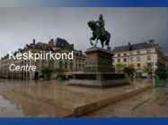
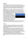
Keskpiirkond Centre Keskpiirkond ● 6 departemangu: Cher, Eure-et-Loir, Indre, Indre-et-Loire, Loir-et-Cher ja Loiret. ● Elanikke: 2 480 000 (2004) Pindala: 39 151 km² ● Keskus: Orléans ● Suurim linn: Tours ● Keskpiirkond Loire jaotab kaheks ● ● Kõrgeimaks punktiks on Mount Saint-Marien (504 m) Kliima: üldiselt jahe ● Juust & vein Juust: ● ● Sainte Maure de Touraine ● Crottin de Chavignol ● Vein: ● Vins de Touraine, Vins du Centre, Vins de l’Orléanais Majandus Põllumajandus ● Turism ● Tööstus ● Vaatamisväärsused Loire'i oru lossid ● üle 300 lossi ● Vaatamisväärsused ● Chartres, Orléans ja Tours. ● Külastatakse muljetavaldavaid katedrale Kasutatud materjalid ● http://www.french-at-a- touch.com/French_Regions/Centre/centre_6.htm ● http://www.regions-of- france.com/regions/centre/weather/ ● https://www.google.ee/search? q=chartres+cathedral+france&biw=1366&bih=600 &source=lnms&tbm=isch&s...
The east coast The east coast consists of a narrow band of lowlands, formed from the sedimentation of alluvial soils and zone, composed of steep bluffs, alternating with ravines bordering an escarpment of about 500 meters in elevation. The coastline is straight, with the exception of the bay. The east coast is considered dangerous for swimmers and sailors because of the large number of sharks that frequent the shoreline. The Tsaratanana Massif region The island's highest peak, Maromokotro, at 2,876 metres is found in the Tsaratanana Massif, located in the far north of the country. The coastline is deeply indented; two prominent features are the excellent natural harbor at Antsiranana and the large island of Nosy-Be. The mountainous topography to the south limits the potential of a port at Antsiranana by impeding the traffic from other parts of the island. The central highlands
ttatcagttagctaactgctatatgggtcgggctgggttgataaactccggcggtgctgc gggcggtgaaactgacctcagcgatgcagtgcgtactgcggttatcaacaaacgcgcagg cggaatggggctgattcttggacgtaaagcgttcaagaaatcgatggctgacggcgtgaa actgattaacgccgtgcaggacgtttatctcgatagcaaaattactatcgcctga 2) CpG Islands CpG Islands results Results for 1053 residue sequence "eco:b2097 fbaB, dhnA; fructose-bisphosphate aldolase class I [EC:4.1.2.13]; K01623 fructose-bisphosphate aldolase, class I (N)" starting "atgacagata" CpG island detected in region 3 to 202 (Obs/Exp = 1.18 and %GC = 50.50) CpG island detected in region 18 to 217 (Obs/Exp = 1.19 and %GC = 50.50) CpG island detected in region 21 to 220 (Obs/Exp = 1.19 and %GC = 50.50) CpG island detected in region 24 to 223 (Obs/Exp = 1.19 and %GC = 50.50) CpG island detected in region 25 to 224 (Obs/Exp = 1.19 and %GC = 50.50) CpG island detected in region 26 to 225 (Obs/Exp = 1.19 and %GC = 50.50) CpG island detected in region 27 to 226 (Obs/Exp = 1.19 and %GC = 50.50)
The report of forested areas encouraged further exploration because the colonies in Greenland which belonged to the Vikings lacked lumber. In AD 1000 Leif Ericson became the first European to land in North America. The first colony was established what was described as Vinland by the Vikings. It was located on the northernmost tip of todays Newfoundland. There has also been a theory that the Vikings penetrated Hudson Bay and reached the Great Lakes region but recent investigations have cast serious doubt on it. The Greenland colony died out during the 15th century and the Viking adventures in Canada must have come to an end long before that time. The Colony of New France By 1600 French interest in Canada was renewed because of the beaver pelt trade and the fishing industry. First French colony was established in eastern Canada. Because of the French settlement the French established a claim to the Gulf of St. Lawrence area
Tibet Tibet is a plateau region in Asia, north of the Himalayas, and the home to the indigenous Tibetan people and some other ethnic groups. With an average elevation of 4,900 metres, it is the highest region on Earth and has in recent decades increasingly been referred to as the "Roof of the World". In the history of Tibet, it has been an independent country, divided into different countries, and a part of China each for a certain amount of time. Tibet was first unified under King Songtsän Gampo in the seventh century. A government nominally headed by the Dalai Lamas, a line of spiritual leaders, ruled a large portion of the Tibetan region at various times from the 1640s until 1950s
Savannas are also known as tropical grasslands. Savannas have warm temperature year round. There are two very different seasons in a savanna; a very long dry season(winter) and a very wet season. In the dry season only an average of about 4 inches of rain falls. In the summer there is lots of rain. The savanna has a large range of highly specialized plants and animals. RainforestThe tropical rain forest is a forest of tall trees in a region of year-round warmth. Rain forests belong to the tropical wet climate group. The temperature in a rain forest rarely gets higher than 34 °C or drops below 20 °C. Rainfall is often more than 100 inches a year. There is usually a brief season of less rain. In monsoonal areas, there is a real dry season. Almost all rain forests lie near the equator. Rainforests now cover less than 6% of Earth's land surface. AlpineCold, snowy, windy. In the summer average temperatures range from 10 to 15° C
strength than the American Falls. People can enjoy the sight and the noise of the waters from boats which take them right next to the falls. And to stay dry people receive waterproof clothing. Parts of Canada are very mountainous and the tallest mountain in Canada is the Yukon's Mount Logan, which is 6050 meters tall. Canada has many mountain ranges. In the east there are the Appalachians, Torngats and Laurentias. In the western region there are the Rocky, Coastal and Mackenzie ranges and Mount St. Elias and the Pelly Mountains in the northern regions. Canada has about two million lakes and they cover about 7.6% of Canada's land. The biggest lakes in order by their surface are Lake Huron, Lake Great Bear, Lake Superior, Lake Great Slave (which is also the deepest), Lake Winnipeg, Lake Erie and Lake Ontario. There are also a lot of rivers in Canada. The longest river is the Mackenzie River which is
shown in parentheses): Alberta (Edmonton), British Columbia (Victoria), Prince Edwars Island (Charlottetown), Manitoba (Winnipeg), New Brunswick (Fredericton), Nova Scotia (Halifax), Nunavut (Iqaluit), Ontario (Toronto), Quebec (Quebec City), Saskatchewan (Regina), Newfoundland and Labrador (St. John's), Northwest Territories (Yellowknife) and Yukon Territory (Whitehorse). Geographically, Canada can be divided into five major regions: the Pacific Region, the Prairie Provinces, Central Canada, the Atlantic Provinces and the North. The Pacific Region includes Canada's westernmost province, British Columbia. The region is known for it's mild coastal climate, its forests and its spectacular mountains, including the famous Rockies. Alberta, Saskatchewan and Manitoba are Canada's Prairie Provinces. They are known for their rolling plains and extreme climate with long, cold winters and hot, dry summers
In fact, Canada`s east coast is closer to Europe than it is to Canada`s west coast. It also extends southward from the North Pole to the US border. Canada`s northen coast is washed by Arctic Ocean, eastern coast by the Atlantic Ocean and western coast by the Pacific Ocean. Canada is so big that it contains six time zones. This huge land mass has been divided by nature into 6 distinct geographical regions. Stretching across the north is the Artic region. On the east there is another geographical unit called the Applachian Region after the range of mountains which run through the New England states north into Canada. Moving west, we come to the largest region of all, the Canadian Shield. This extends like a huge semi-circular ring around Hudson Bay. It is rugged, stony and with thin soil. Southeast of the Shield is the Valley of the St. Lawrence River which embraces the parts of Quebec and Ontario that lie along that river and Lakes Ontario and
eyes. Highlands turn into lowlands; forests and hills turn into meadows and plains very quickly. It's hard to believe, but in Great Britain one you can find practically any type of scenery. Britain is unusually beautiful country! England can be divided for four parts: the Southeast, the Southwest, East Anglia, the Midlands and the North of England. The Southeast is a highly populated region of England. London, the capital of the UK, and such historical cities as Windsor, Dover and Brighton are situated here. When people travel to Britain by sea or by air they usually arrive in the Southeast, for this is where the main passenger ports and airports are. Heathrow airport, one of the world's busiest airports is about 33 km west of central London. The Southwest is the region where the main activity is farming. The Southwest used to be known for its pirates
and severe climate. Canada extends across the continent of North America, from Newfoundland on the Atlantic coast to British Columbia on the Pacific coast and northward into the Arctic Ocean. Canada shares land borders with the United States to the south and north-west. Canada is a land of great variety. Towering mountains, crystal-clear lakes, and lush, green forests make Canada's far west a beautiful region. Farther inland, fields of wheat and other grains cover Canada's vast prairies. Thes fertile farmlands contrast vividly with the Arctic wastelands to the north. Most of the largest towns and industrial areas lie near the Great Lakes and the St Lawrence River in central Canada. In the east, fishing villages and sandy beaches dot the Atlantic coast. Across the country, Canadians experience many different landscapes from rolling plains and mountains to the cold tundra of the north.
Kashmir What is it? Kashmir is the northwestern region of the Indian Subcontinent.Until the mid-19th century, the term Kashmir geographically denoted only the Valley between the Great Himalayas and the Pir Panja mountain range. Today, it denotes a larger area that includes the Indian-administered state of Jammu and Kashmir (which consists of Jammu,Kashmir Valley. Culture Kashmiri cuisine includes dum aloo (boiled potatoes with heavy amounts of spice), tzaman (a solid
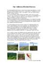
The California Floristic Province The California Floristic Province is a zone of Mediterranean-type climate and has the high levels of plant endemism characteristic of these regions. The hotspot is home to the giant sequoia, the planet's largest living organism and its taller but less massive relative, the coastal redwood. This region also holds a number of threatened endemic species such as the giant kangaroo rat and the desert slender salamander, and some of the last individuals of the Critically Endangered California condor can still be found here. In fact, it is the largest avian breeding ground in the United States. Wilderness destruction caused by commercial farming is a major threat for the region as the California Floristic Province generates half of all the agricultural products used by U.S. consumers
The British colonists wanted new farmland and French fur traders had forts, which they refused to move. By 1758, the British had conquered the French fortress of Louisbourg at the entrance of the St. Lawrence River. This was the beginning of the end for French rule in North America. In September 1759, the British attacked the French on the Plains of Abraham and won. The following spring they also conquered Montreal. The British renamed the new French-speaking region Quebec. They allowed the French to keep their Roman Catholic religion, civil law system and language, so that they would not try to break away from Britain. From 1775 to 1784, many British came to the former New France area from south. The people in American colonies were fighting for independence and those people who fled north were the one who wanted to remain loyal to Britain (United Empire Loyalists). Britain created two new colonies: New Brunswick and Upper Canada
(223.5 x 104 x 122 cm.) Jellyfish ARTIST: Takashi Murakami WORK DATE: 2003 CATEGORY: Prints MATERIALS: Offset lithograph MARKINGS: Hand Signed and numbered in pencil SIZE: h: 68.2 x w: 68.2 cm / h: 26.9 x w: 26.9 in REGION: Japanese STYLE: Contemporary (ca. 1945present) TanTanBo ARTIST: Takashi Murakami WORK DATE: 2003 CATEGORY: Prints MATERIALS: Lithograph in colors MARKINGS: Signed and numbered SIZE: h: 65.9 x w: 99.8 cm / h: 25.9 x w: 39.3 in REGION: Japanese STYLE: Contemporary (ca. 1945present) Reversed Double Helix Reversed Double Helix Takashi Murakami 2003 Photo by Tom Powel Organized by Public Art Fund and Tishman Speyer Properties Presented by Target Stores Courtesy: Marianne Boesky Gallery Photo by Tom Powel Näitus Brooklyn Museum of Modern Art Siin võib näha: Kaikai Kiki News NO2 Flower (Superflat) by ~DemonOfAlchemy
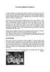
Indigo was the first dye to be widely bought during the 18th century. Today Estonian traditional costume is the most spectacularly exposed at "laulupidu", the national song festival, both on the stage and among the audience. Local differences were noticed by the first ethnographers describing Estonians. The main regions fall into South, North, and West Estonia, and the islands as a separate group, reflecting ancient tribal peculiarities. South Estonia This region is the most conservative in dress. Maidens in Southern Estonia bound their hair with a ribbon plaited from colourful pieces of cloth or woollen yarns. Instead of a skirt, the Setu women wore a garment resembling the Russian sarafan. Setu women were extremely fond of silver ornaments: on their chest they wore a conical brooch, in addition to various silver chains. Traditionally, the large setu brooch was only worn by women of child-bearing age; nowadays older women, too, use it as a decoration.
Russo-European Slaid- origin Ise räägid: Russo-European Laika is the name of a breed of hunting dog that originated in the forested region of northern Europe and Russia Slaid- Attitude Ise räägid: The Russo-European Laika is a very affectionate and strongly attached to the master and his family.It is a territorial dog and displays aggressiveness towards unfamiliar dogs intruding their place. All Russo-European Laikas are aggressive to predators and are enthusiastic hunters for many kinds of small and big game. However, their hunting attitude is very discriminating. Slaid-Utilization (kasutamine)
Mid-Atlantic region; 3) the South; 4) the Midwest; 5) the Southwest; 6) the Rocky Mountain region; 7) the Pacific Northwest and Alaska; 8) California and Hawaii. New England is highly industrial, but it also has many fields, woods and small towns. New England is the part of the United States that is most like "old" England. It includes six states: Maine, New Hampshire, Vermont, Massachusetts, Rhode Island, and Connecticut. The Mid-Atlantic region plays an important role in the United States. Its cities include Washington D. C., the nation's capital, and New York City, the nation's financial centre. The Mid-Atlantic region is densely populated. It includes six states: New York, New Jersey, Pennsylvania, Delaware, Maryland and West Virginia. The South is economically, historically and culturally a distinct region. With its warm climate and rich soil, it developed an economy based on cotton export. Conflicts between
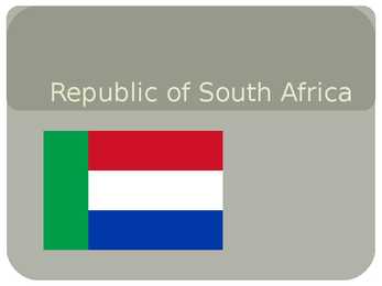
- National Assembly and National Council of Provinces ( must ensure that provincial interests are taken into account in the national sphere of government ) Economy GDP 22 730,725 US $ per capita, 20,858 billion US $ total The Nelson Mandela Bridge in Johannesburg. Gauteng produces 33% of South Africa's GDP and 10% of the African continent's GDP GDP 10,136 US $ per capita, 277,4 billion US $ total Living standards Living standards are different from region to region Natural resources Main resources are ores More about Resources 1 Exports 2 3 1 Imports 2 3
How high is the highest mountain in the UK? Ben Nevis, 1,343m 3.Describe the relief of Scotland. Scotland is quite mountainous and there is also situated the highest peak in the UK, Ben Nevis. The Scottish Highlands cover the northern part of the country. Here The Northwest Highlands have rocky lunar landscape. South of Scotland is mostly covered with the Grampian Mountains which forms with some other mountains a huge mountain mass. The Central Lowland lie south of the Scottish Highlands. This region is a gently rolling plain. It has best farmland, and richest coal deposits. The Southern Uplands rise gently south of the Central Lowlands. This is a region of rounded, rolling hills. 4.What are the possibilities of land use in Scotland? Tourism in the mountains, there you can ski and climb mountains. In the north there doesn't live much people, so there people raise sheep or go fishing. In the Central Lowlands, people earn living from farming and there is Scotland's richest coal deposit
Moose are herbivores. The male moose have big antlers, female ones don't have them. Prairie dogs are very funny-looking animals. They are rodents who live in tunnels under the ground. They are very good diggers. Prairie dogs are 30 centimetres long. They eat insects and grass. Land. Canada is divided into five major regions geographically: the Pacific Region, the Prairie Provinces, Central Canada, the Atlantic Provinces and the North. The Pacific Region includes British Columbia. The region is known for its mild coastal climate, its forests and its spectacular mountains, including the famous Rocky Mountains. Vancouver and Victoria are the largest cities in this area. Alberta, Saskatchewan and Manitoba are Canada's Prairie Provinces. They are known for their rolling plains and extreme climate with long, cold winters and hot, dry summers. Much of the area is covered with farms producing large quantities of wheat and other grains
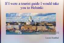
If I were a tourist guide I would take you to Helsinki [1] Laura Runthal Info ● Country: Finland ● Region: Uusimaa ● Sub-region: Helsinki ● Largest city in Finland ● Itis shopping centre(1984) ● is a large shopping mall in the Eastern suburbs ● It is the largest fully enclosed shopping centre in the Nordic countries, with a gross leasable area of 120,300 square metres containing nearly 300 different shops (including about 30 restaurants and cafés) and 3000 parking spaces. Located nearby is also the Itäkeskus metro station.
U.S. · Mount Rainier is a massive stratovolcano located 54 miles (87 km) southeast of Seattle in the state of Washington, United States. North Cascades National Park is a U.S. National Park located in the state of Washington. The park is the largest of the three National Park Service units that comprise the North Cascades National Park Service Complex. Largest cities in Washington State is · Seattle Seattle is the largest city in the Pacific Northwest region of North America and the largest city on theWest Coast north of San Francisco. City population is 563,374. · Spokane It is the largest city of Spokane County, of which it is also the county seat,[5] and the metropolitan center of the Inland Northwest region. The city is located on theSpokane River in Eastern Washington. 230 miles east of Seattle. City population is 195,629. · Tacoma s a mid-sized urban port city and the county seat of Pierce County, Washington, United States
Accommodation in Lahemaa region Introduction Lahemaa region consists of tree rural municipalities Kuusalu, Vihula, Kadrina and one small town Loksa, in North-Estonia. Accommodation in Lahemaa represents almost all allowed types according to Estonian tourism law. There are some differences between accommodation types in Estonia and Great Britain. Comparison of the accommodation ways in Lahemaa and Great Britain The types of accommodation in Lahemaa are: villa, guesthouse, hotel, tourist farm, bed
pollution. As a result, this global pollution issue causes great debates between countries that fight over polluting each other's environments. For years, science studied the true causes of acid rain. Some scientists concluded that human production was primarily responsible, while others cited natural causes as well. Recently, more intensive research has been done so that countries have the information they need to prevent acid rain and its dangerous effects. The levels of acid rain vary from region to region. In Third World nations without pollution restrictions, acid rain tends to be very high. In Eastern Europe, China, and the Soviet Union, acid rain levels have also risen greatly. However, because acid rain can move about so easily, the problem is definitely a global one. Kirsika Jürisson 10.A Tallinna 37. Keskkool Õpetaja: Annika Vilu
England. There are two main languages in Canada: English and French. Canada's curreny is Canadian dollar (1 dollar=100 cents[Can$]). The highest peak of Canada is Mount Logan, 5959 metres. The lowest point is sea level. The longest river is the Mackenzie. The climate and geography of Canada vary greatly from temperate in the south to arctic in the north and from islands and plains in the east to mountains in the west. Location Canada is located in the northern-most region of North America. It's geographical position in co- ordinates is 83°N north, 42°N south, 53°W east, 141°W west. Canada borders with United States of America by land; Pacific Ocean, Arctic Ocean and Atlantic Ocean by coastline. Canada is one of the largest countries in the world, second only to Russia in territorial size. It has a total area of 9.9 million square kilometers. This includes 755,170 square kilometers of water. Toronto is the largest city in Canada with a population of 4
located on rue Donnaconna in Quebec City. Indeed, it is only 3.7 meters long. The Château Frontenac in Quebec City is the most photographed hotel in the world. Quebec contains more than 3% of the world's fresh water reserves. Quebec's forest covers more than 750,000 km2, which is the size of Sweden and Norway together. It represents 20% of the Canadian forests and 2% of the world's forests. Facts about Quebec In the Baie-James region you can find LG2, the largest underground hydroelectric power plant in the world. Road 132 is the longest road in Quebec. It is more than 1,400 km long and goes from the Montérégie region to the Gaspésie region on the south shore of the St. Lawrence River.
Saarland Das Saarland ist ein Bundesland im Südwesten der Bundesrepublik Deutschland. Es grenzt im Norden und Osten an das Land Rheinland-Pfalz, im Süden an Frankreich und im Westen an Luxemburg. Zusammen mit der französischen Region Lothringen (Lorraine), dem Großherzogtum Luxemburg, dem deutschen Bundesland Rheinland-Pfalz und der belgischen Region Wallonien bildet das Saarland die Großregion Saar-Lor-Lux. Die West-Ost-Freundschaftsgesellschaft im Saarland ist eine weltanschaulich, von politischen Parteien und staatlichen Institutionen unabhängige Vereinigung. Die Gesellschaft wurde im September 1955 gegründet und feierte 2005 ihr 50-jähriges Jubiläum. Der Verein wirkt in den Bereichen Wirtschaft, Ökologie, kultureller Austausch und humanitäre Projekte in und mit den ehemaligen Republiken der Sowjetunion.
USA ajaloo konspekt (algus-Mayflower Compact) 1. Name the regions of the USA New England, Middle Atlantic, South, Midwest, Southwest, West. 2. Name the states that make up each region. NE: Maine, New Hampshire, Vermont, Massachutsess, Rhode Island, Connecticut. MA: New York, Pennsylvania, New Jersey, Maryland, Delaware. S: Virginia, North Carolina, South Carolina, Georgia, Florida, Alabama, Mississippi, Louisiana, Missouri, Arkansas, Kentucky, Tennessee, West Virginia. MW: North Dakota, South Dakota, Nebraska, Illinois, Michigan, Kansas, Minnesota, Iowa, Indiana, Wisconsin, Ohio. SW: Arizona, New Mexico, Texas, Oklahoma.
Latvia Capital city: Riga Total area: 65 000 km² Population: 2.3 million Language: Latvian Latvia, officially The Republic of Latvia, is a country in the Baltic region of the Nothen Europe. The country has a temperate seasonal climate. Latvia and Estonia share a long common history. As a consequence of the Soviet occupation both countries are home to a large number of ethnic Russians (26.9% in Latvia and 25.5% in Estonia). Latvia was found on 18th November 1918. However, its independence was interrupted at the outset of World War II. In 1940, the country was forcibly incorporated into the
HAAPSALU By Marika Form 7 HAAPSALU Seaside resort town located on the west coast of Estonia Administrative centre of Lääne County Population - 11,618 Tallinn 100 km away White Lady Western Region Administrative Centre Area - 10,59 km2 HISTORY The German Knights of the Sword conquered this region in 1224, and Haapsalu became the bishop's residence, with a fortress and cathedral built soon afterwards. The Danes took control during the Livonian War then the Swedish had their turn in the 17th century, but they lost it to the Russians during SYMBOLS Flag-blue and white, the flag is confirmed on 27 September 1994 Coat of arms- of the 27th confirmed September 1994 NATURE A few rivers and lakes A lot of deciduous trees and coniferous trees Lakes- Vaikeviik lake
Due to the country's huge size and position, it is very diverse. It is bordered by the Pacific Ocean to the west, the Atlantic to the east, and the Arctic to the north. The landscapes differ greatly from rolling plains and mountains to the cold tundra in the northern part of the country. Geographically, the country's split into 5 major regions the Pacific, the Prairie Provinces, Central Canada, the Atlantic Provinces and the North. The Pacific Region is known for its mild coastal climate, its forests and its spectacular mountains. The three Prairie Provinces are known for their rolling plains and their extreme climate with long, cold winters and hot, dry summers. Part of the Rocky Mountains are in the there. A lot of the Prairie Provinces' area is covered with farms producing wheat and other grains. The region is rich in oil and natural gas. In fact, Canada is the second largest oil reserve holder in the world, after Saudi Arabia.
Estonia Tjorn Treu KP-31 Information · Area- 45,227 km2 · Population- 1,282,963(2011 july) · Location- Baltic Region of Northern Europe · Capital- Tallinn · Main cities- Tallinn,Pärnu,Tartu,Narva · Official Language- Estonia · Political structure- democraic republic National symbols Flag- Coat of arms- Anthem-"My Fatherland, My Happiness and Joy,, Plant-cornflower Bird-chimney swallow Stone-slate Tree- Oak History DATES Independence Day (Iseseisvuspäev) - February 24 May Day (kevadpüha) - May 1 National Flag Day (Eesti lipu päev) - June 4
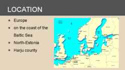
Introduction Estonia, officially the Republic of Estonia (Estonian: Eesti or Eesti Vabariik) is a country in the Baltic region of Northern Europe. It is bordered to the north by Finland across the Gulf of Finland, to the west by Sweden across the Baltic Sea, to the south by Latvia (343 km), and to the east by the Russian Federation (338,6 km). The territory of Estonia covers 45,227 km² and is influenced by a temperate seasonal climate. The Estonians are a Finnic people closely related to the Finns, with the Estonian language sharing many similarities to Finnish. The modern name of Estonia is
· Soil improvement · Special forest plantations · Fertilisation · Plant breeding Forest Industry: · Felling of the trees · Processing of timber · Trees grow: 80-100 years in the wild, 60-70 years with the help of people The usage of forests: 1. Gathering · To live, get food and shelter from the woods · Don't change or harm the forests 2. EarlyAgrarian m.m. · Slash and burn -> woods replaced by brush (võsa) · Typical to Mediterranean region and East-Asia 4. Late Agrarian m.m · Very bad situation primeval fields · Population growing necessity much bigger · Forests preserved on slopes of mountains and where infertile soils were. · West Europe, North America 4. Early Industrial m.m · Development of forestry -> timber industry · Wood from boarderlands and colonies · Subequatorial and equatorial regions valuable woods · Temperate zone coniferous woods soft timber
By the 19th Century the sandwich had become popular all over Europe, especially in England because of the industrial revolution. People needed easytomake, easyto carry lunches that would fill them up for a long day of work at the office TYPES OF SANDWICHES Sandwiches are now popular all over the world,. Would you believe that now Americans eat more than 300 million sandwiches a day? every region has their own take on the concept. Sandwiches come in endless varieties, making them one of the most popular foods worldwide. Here’s an example of few most popular ones. BLT: Bacon, lettuce and tomato were one of the greatest things to happen to sliced bread. Chip Butty: A chip butty consists of two slices of buttered white bread around a portion of chips and top off with some ketchup. It comes from the UK.
). Register-analysis Language user vs. language use – the two main parameters of language change. Variability in the language user is further defined by three broad parameters: 1-Time- (when?) the time when the speaker or the writer lived. For example, if you were to translate a Dickens book from english to russian, you could use the same language as did Dostoyevsky, because they lived at the same time (19th century) 2-Region- The second parameter that defines the language user is region. Region refers to where the author/speaker (sometimes character) is from. May be on a broader scale – Middle East, Western world; but also narrower – Germany, Latvia, Minnesota; and even narrower – Conrwall, London, Pärnu, etc. Problems related to region (similar to the problems covered in previous lessons): How to deal with a situation, where all or part of a source text is written in a regional language? This involves questions along the lines of – if
2009 population of 1,220,674, making it the country's fourth largest metropolitan area. Although a recent StatsCan estimate in February 2010 surmises that the Ottawa metropolitan area has recently been surpassed by the Calgary metropolitan area as the Canada's fourth largest metropolitan area. There is no federal capital district in Canada. Although it does not constitute a separate administrative district, Ottawa is part of the federally designated National Capital Region (NCR), which encompasses Ottawa, Gatineau, and surroundings areas, having a population of over 1,451,000[6]. The National Capital Commission is a federal crown corporation charged with the responsibility of planning and managing the federal government's interests in the NCR.As with other national capitals. Ottawa The City of Halifax (est. 1841) was the capital of the province of Nova Scotia and shire town
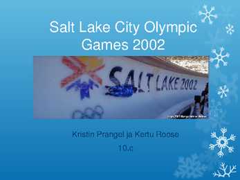
Salt Lake City Olympic Games 2002 Kristin Prangel ja Kertu Roose 10.c General Information XIX Olympic Games February 8th through February 24 George Washington Bush Olympic fire Host city and location Changes New facilities High mountains Salty lake Rocky Mountain Region Olympic Village Symbols Motto: Citius, Altius Fortius Powder Copper Coal Snowflake Light the Fire Within Events 78 events Olympic medals Venues Worldclass venues 14 different places 10 to 60 minute drive Community facilities Highlights Ole Einar Bjørndalen Samppa Lajunen China Janica Kosteli Other information 1st Winter Olympic games. The most recent games 78 athletes Estonian athletes 18 competitors Biathlon Cross country skiing Figrue skater
including fire, ambulance, police, parks, roads, sidewalks, public transit, drinking water, stormwater, sanitary sewage and solid waste. Calgary Calgary is the largest city in the Province of Alberta, Canada.It's population is about 1 065 000 people. It is located in the south of the province, in an area of foothills and high plains, approximately 80 km east of the front ranges of the Canadian Rockies. The city is located in the Grassland region of Alberta. Calgary is the third largest civic municipality, by population in Canada. Located 300 km due south of Edmonton, statisticians define the narrow populated area between these cities as the "Calgary-Edmonton Corridor." Calgary is the largest Canadian metropolitan area between Toronto and Vancouver. Calgary is well-known as a destination for winter sports and ecotourism with a number of major mountain resorts near the city and metropolitan area. Economic activity in Calgary
This a little help they who play with Gameforge games, no fraud/there is not a ramp in him, not hack the side... The essence that Paypal we nag it. Your monthly premium may turn up with this little trick and maybe yet a little one other service what the pay part of the given game provides. So: The 1. As a step register onto PayPal side. On this link https://www.paypal.com/us/cgi-bin/webscr?cmd=_registration-run There will be a cell like this there: Your country or region let us put Ez in another place The one under it Your language leave it so on the factory setting. (U.S. English) Then vállasszuk who from among the 3 opportunities Personal Account -ot and push Get Startedre. ! On the appearing sheet got now much kitlteni truth data. (To grant worthy real data) ! Email address : Here grant your real email address. Choose the password : Select a password (there have to be at least 8 characters) First name : Your first name Last name : Your surname
shareholder is the Republic of Estonia. Port of Tallinn consists of five harbors. These harbours are The Old City Harbour, Muuga Harbour, Paljassaare Harbour, Paldiski South Harbour and Saarema Harbour. All these harbours are navigable all year round. · Muuga Harbour biggest cargo harbour in Estonia. It is located 17 kilometers east from Tallinn, built on the coast of Muuga Bay. Muuga Harbour is the deepest (up to 18 m) and most modern ports in the Baltic Sea region. · The Old City Harbor one of the biggest and busiest passenger harbor in the Baltic Region. It is located in the heart of the city of Tallinn. By the year 2008, 7 247 366 passengers had travelled through the Port of Tallinn. That is remarkable. · Paljassaare Harbor - one of the most sheltered harbors in Estonia in terms of winds and waves. It is situated on Paljassaare Peninsula in Tallinn, about 6 kilometres from the centre of the city.
The Mountain Lion cougar (Puma concolor), also puma, cougar, or panther, is a member of the Felidae family, native to the Americas. This large, solitary cat has the greatest range of any wild land mammal in the Western Hemisphere, extending from Yukon in Canada to the southern Andes of South America. An adaptable species, the cougar is found in every major North American habitat. The Mountain lions of Yellowstone region were significantly reduced by predator control measures during the early 1900s. It is reported that 121 lions were removed from the park between the years 1904 and 1925. Then, the remaining population was estimated to be 12 individuals. Mountain lions apparently existed at very low numbers between 1925 and 1940. They maintain a secretive profile in the Yellowstone region. Although the cougar population numbered in the hundreds during the early 1900s, controlled hunts between 1904 and 1925
NEWFOUNDLAND AND LABRADOR TRIINU PRANTS GUSTAV ADOLFI GÜMNAASIUM 8. C KLASS GEOGRAPHICAL LOCATION · Country's atlantic region · Most easterly province · Island of Newfoundland and mainland Labrador · Area of 405,212 square kilometres · Capital St. John's http://en.wikipedia.org/wiki/Newfoundland_and_Labrador#/me dia/File:Newfoundland_and_Labrador_in_Canada.svg FLAG http://en.wikipedia.org/wiki/List_of_premiers_of_Newfoundland_and_Labrador POPULATION · In 2013 526 702 people · 92 % of population on the Newfoundland · 40% on population in St
● 1345 - Danes sold Tallinn to the Teutonic Order ATTRACTIONS ● Toompea Castle ● Old Town ● Town Hall ● Kadriorg - beautiful park ● City Centre - medieval churches, modern towers OLD TOWN ● listed in the UNESCO world heritage list ● built up from the 13th to 16th centuries ● old Hanseatic town ● surrounded by huge walls ● many towers, narrow streets TOWN HALL ● on the Town Hall Square ● built in 1402-1404 ● oldest in the Baltic region and Scandinavia ● tower height is 64 m ATTRACTIONS Old Town Town Hall ATTRACTIONS Park Kadriorg City Centre Thank you for listening!
al. [7]. points where the program had placed the nucleotides. As each run has its specific signal intensity level, the signals from PCR amplification, cloning and sequencing different runs were normalized, so that the mean of the intensities The ITS region including ITS1, 5.8S gene and ITS2 was in a sequence would be as close as possible to 1000 units. Then to amplified using the primers 18Sfw: 59-TAC ACA CCG CCC obtain the expected values, the mean value among clones for a GTC GCT ACT A and 28S59rev: 59-GAC GTG CCT TTC particular nucleotide in each position was found. The normaliza- CAG GTC AAC TT
The Prarie Provinces Main Facts The Prairies comprise the states of Alberta, Saskatchewan and Manitoba Covers about 2,1 million square kilometers. About 5,7 million people live in that region. What is a Prarie? Prarie (aslo known as a temperate grassland) is a treeless ecozone in North America. Different names in different countries. Only about 400 mm per year. Hot summers and cold winters. Humans and the Prairies Almost 95 % of the Prairies are converted into farmland. The biggest towns are Calgary, Saskatoon and Winnipeg. The main argiculture industries are wheat, barely and canola.
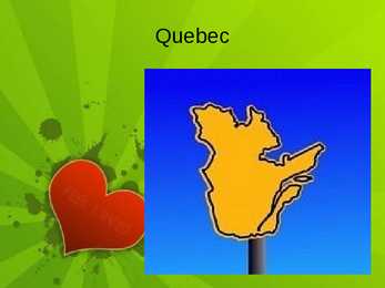
Largest river the St. Lawrence River Canadian Shield 90% of the territory Appalachian Mountains History First inhabitants were the indigenous people First French explorer Jacques Cartier 1534 First it was called New France In 16. 17. century population grew massively The Seven Year's War in 1756-1763, New France was renamed the Province of Quebec Act of Union in 1840 Economy The St. Lawrence River Valley is a agricultural region The nothern coniferous forests, lakes and rivers have many resources Many high-tech industries around Montreal Goverment Head of state is Queen Elizabeth II Head of goverment is Premier Jean Charest Political Structure is parliamentary democracy Thank you!
Dear Sir or Madam, I am writing to apply for the advertisement on your website requesting for volunteers to join a conservation expedition to a remote region of Costa Rica. I speak basic Spanish. I had learned Spanish at school for a year and after that I went to Spain. I lived there for a few years and I can easily speak with local community without any problems. I also took part in different swimming competitions. I like long distance in an openwater, so it is not a challenge for me to swim a lot and fast in the river or in the sea. I have two queries about the expedition. Firstly, could you please inform me
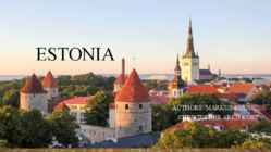
ESTONIA AUTHORS: MARKUS KUUSE, CHRISTOFHER ARKO KÖST FACTS ABOUT ESTONIA • Estonia is about 50% forest • Estonia has over 2000 islands • Estonia was the first country in the world to use online political voting. HISTORY • Humans settled in the region of Estonia near the end of the last glacial era • In the Middle Ages, Estonia became a battleground for centuries where Denmark, Germany, Russia, Sweden and Poland fought their many wars • Estonians declared their independence in February 1918 RECENT HISTORY • In 1940, the Soviet Union occupied Estonia • Nazi Germany occupied Estonia in 1941; later in World War II the Soviet Union reoccupied it (1944). GEOGRAPHY • The two largest islands are Saaremaa and Hiiumaa