Leidsid 33 sarnast õppematerjali, mis on seotud failiga "Quebec.". Need materjalid aitavad sul teemat sügavamalt mõista.
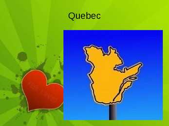
quebec, river, first, montreal, french, lawrence, france, land, square, official, language, coat, flower, blue, iris, bird, mineral, yellow, birch, holiday, june, geography, situated, eastern, part, canada, highest, canadian, shield, mountains, explorer, jacques, century, seven, year, 1763, province, economy, valley, region, forests, lakes, rivers, techQuebec Quebec Province in east-central Canada. The only Canadian province with a predominantly French- speaking population. Largest province by area. second-largest administrative division. Bordes West by the province of Ontario, James Bay and Hudson Bay. North by Hudson Strait and Ungava Bay. East by the Gulf of Saint Lawrence, Newfoundland and Labrador and New Brunswick. South the U.S.A. Geography 90% of Quebec's territory lies within the Canadian Shield The Eastern Canadian forests cover the Appalachian Mountains Climate Most of central Quebec has a subarctic climate. Winters are long, very cold, and snowy. Summers are warm but very short. History
CANADA Geography Canada is the world's second largest country in total area after Russia , since it covers nearly 10 million square kilometres, but is one of the most sparsely populated, with only about 34 million inhabitants. The majority of them live within 300 kilometres of Canada's southern border. Much of the rest of Canada is uninhabited or thinly populated, because the country has a rugged terrain and severe climate. Canada extends across the continent of North America, from Newfoundland on the Atlantic coast to British Columbia on the Pacific coast and northward into the Arctic Ocean. Canada
Canada. Canada is a very big country in the continent of North America. It is about 10 million square kilometres and that makes it the second largest country in the world after Russia. Quebec (the province) is six times as big as the UK. Canada borders the Atlantic Ocean, the Pacific Ocean, the Arctic Ocean and the USA. The capital of Canada is Ottawa and other main cities are Toronto, Montreal and Vancouver. It is a very developed country. Montreal is the largest city and it is called the Paris of North America because most of the people there speak French. The population of Canada is 28 million people. It is a very multicultural country. People from many different countries have come to live there. The natives are Eskimos and Indians. Eskimos have their own self-governing homeland called Nunavut. In Canada there are also 2 official languages English and French. One
History First people who lived in Canada came by a land bridge from Russia and Greenland. They were the ancestors of nowadays indigenous people of Canada. They just searched better for living places and followed their prey and they didn't even know they were on a different continent. The first explorers were Norse seafarers known as Vikings. As they sailed from Iceland to Greenland in AD 985, they were blown far off their course and they saw the coast what must have been Labrador. The forested areas of Canada's coast encouraged further explorations, because their settlement lacked lumber. They established a colony, what they called Vinland on Newfoundland. It died out during the 14th and 15th centuries.
Topic Canada Tallinn English College 2006 1. Introduction If you had to use two words to describe Canada, they might be large and diverse. Canada is the second largest country in the world with a territory of about 10 million square kilometers and it is bordered by three oceans: the Arctic, the Pacific and the Atlantic Oceans. The population of Canada is about 31 million people. About 77% of the people live in cities which lie in a band about 100 miles wide above the border of the United States. The capital of Canada is Ottawa. Other large cities are Montreal, Toronto, Vancouver, Winnipeg and Quebec. 2. Geographical position
CANADA REVISION QUESTIONS 2010 1. The main physiographic regions of Canada. Canada may be divided into seven physiographic regions: Arctic Lowlands, Cordilleran Region, Interior Plains, Hudson Bay Lowlands, Canadian Shield (Forest Lands), St Lawrence Lowlands and Appalachian Region. Divisions are based on each area's relatively similar physical geography and landforms. Physiographic regionalization is defined here as the process by which regions with relatively homogeneous physical geography are determined 2. Who are the native people of Canada? Into which three groups can they be divided? Canada's constitution specifies three categories of aboriginal peoples: Indian (First Nations), Métis, Inuit.
Canada Geography The geography of Canada is vast and diverse. Occupying most of the northern portion of North America, Canada is the world's second largest country in total area. The highest point in Canada is Mount Logan 6,050 m, which is in the Yukon. The two principal river systems are the Mackenzie and the St. Lawrence. The St. Lawrence, with its tributaries, is navigable for over 3,058 km. The largest lake situated entirely in Canada is Great Bear Lake at 31,328 km2 in the Northwest Territories. The largest lake which is at least partly in Canadian territory is Lake Superior Climate Canada's climate is as diverse as its landscape. Generally, Canadians enjoy four very distinct seasons, particularly in the more populated regions along the US border. Daytime
Early History The first inhabitants of Canada were native Indian people who were called as Inuits. They are believed to be in Canada since about 10000 BC. The Inuits came to Canada from Asia crossing the Bering land bridge. The earliest discoveries in Canada were made by the Vikings. In AD 985 Vikings sailing from Iceland to Greenland were blown westward off their course and the Vikings sighted the coast of Labrador peninsula. The report of forested areas encouraged further exploration because the colonies in Greenland which belonged to the Vikings lacked lumber. In AD 1000 Leif Ericson became the first European to land in North America.
plains and mountains to the cold tundra of the north. Despite Canada's great size, it is one of the world's most sparsely populated countries. This fact, coupled with the grandeur of the landscape, has been central to the sense of Canadian national identity. 2. Geographical position Canada is the second largest country in the world after Russia. In the Arctic, Canada reaches almost as far north as Greenland. To the south it extends to the same latitude as southern France. The distance from Canada's west coast, the Pacific Ocean, to its east coast, the Atlantic Ocean, is farther than from North America to Europe. Canada's total land area includes thousands of adjacent islands, notably Newfoundland in the east and those of the Arctic Archipelago in the north. In longitude Canada extends from approximately 52° to 141° W, a distance that spans six time zones. In latitude it extends from approximately 42° to 83° N. With its vast
Tallinna Inglise Kolledz Canada. The land of diversity. Tallinn 2006 Canada. If you had to use two words to describe Canada, they might be large and diverse. Canada is the second largest country in the world with a territory of about 10 million square kilometers and it is bordered by three oceans: the Arctic, the Pacific and the Atlantic Oceans. The population of Canada is about 31 million people. About 77% of the people live in cities which lie in a band about 100 miles wide above the border of the United States. The capital of Canada is Ottawa. Other large cities are Montreal, Toronto, Vancouver, Winnipeg and Quebec. Canada has two official languages English and French
Composer: Kärt Kalvet 2010 Canada, Kärt Kalvet 8a Canada General Information Canada is in North America. It's area is 9220970 sq km. Canada's population is 313.612.000 people. Canada is divided into 10 provinces and 3 territories. The capital of Canada is Ottawa. Canada has constitutional monarchy. The head of state in Canada's government is the Queen of England. There are two main languages in Canada: English and French. Canada's curreny is Canadian dollar (1 dollar=100 cents[Can$]). The highest peak of Canada is Mount Logan, 5959 metres. The lowest point is sea level. The longest river is the Mackenzie. The climate and geography of Canada vary greatly from temperate in the south to arctic in the north and from islands and plains in the east to mountains in the west. Location Canada is located in the northern-most region of North America. It's geographical position in co-
Tallinn English College CANADA Report Karin Kristen Tapupere 8.b Instructor: Tiiu Martma Intro: Canada is a country occupying most of northern North America, extending from the Atlantic Ocean in the east to the Pacific Ocean in the west and northward into the Arctic Ocean. It is the world's second largest country by total area and its common border with the United States to the south and northwest is the longest in the world. The land occupied by Canada was inhabited for millennia by various groups of Aboriginal people. Beginning in the late 15th century, British and French expeditions explored, and later settled along, the Atlantic coast. France ceded nearly all of its colonies in North America in 1763 after the Seven Years' War. In 1867, with the union of three British North American colonies through Confederation, Canada was formed as a federal dominion of four provinces. It is a bilingual and multicultural
CANADA Canada is a vast country, second largest country of the world after Russia. It stretches from the Atlantic Ocean in the east to the Pacific Ocean in the west and to the Arctic Ocean in the North. Canada Covers most of the northern part of North America and its geography is very diverse. Canada's area is about 10 million square kilometers and its population is 31 000 000. Its capital is Ottowa and other main cities are Toronto, Montreal and Vancouver. Almost 75 % of canadians lives within 300 kilometer of the USA border, because the climate is softer in the South. 89 % of Canada is almost unhabited. Its official languages are English and French, but many other languages are spoken too. Like Italian, Chinese, German, Polish, Ukrainian, Dutch and Creek. There are also many native languages such as Algonquian. Most of the canadian's speak English (67 %), but French is very largely spoken too (26 % of the canadians)
Territory and landscape Canada is one of the largest countries in the world. It covers nearly 4 million square miles. It is dividend into ten provinces( British Columbia, Manitoba, New Brunswick, Alberta, Nova Scotia, Ontario, Prince Edward Island, Quebec, Saskatchewan, Newfoundland ) along with two territories( the Yukon, the Northwest territories ). The capital city is Ottawa. Canada is a country rich in forests. It borders in the south with The United States and it's surrounded in the west by the Pacific Ocean, in the east by the Atlantic Ocean and above by many smaller bays, but is also borderedd with Alaska in the north-west. To the north of Canada is the broad Canadian Shield, an area of rock scoured clean by the last ice age, thinly
Canada is the second largest country in the world. Situated to the north of the United States, in North America, it has both English and French as its official languages. Even though its area is bigger than that of the United States, its population is only about 11% of that of the USA some 35 million. Because of that, Canada has one of the lowest population densities in the world. The capital of Canada is Ottawa the name of whose comes from the old Algonquin language, with the original word meaning `to trade'. Due to the country's huge size and position, it is very diverse. It is bordered by the Pacific
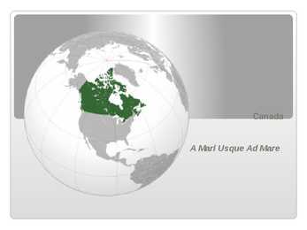
Canada A Mari Usque Ad Mare Official language(s) English, French Inuktitut, Inuinnaqtun, Cree, Recognised regional languages Dëne Sliné, Gwich'in, Inuvialuktun, Slavey, Tlch Yatiì Languages in Canada North American country consisting of ten provinces and three territories located in the northern part of the continent, it extends from the Atlantic Ocean in the east to the Pacific Ocean in the west, and northward into the Arctic Ocean spanning over 9
Topic Canada History The first people to live in what is now Canada arrive from Asia at least 20 000 years ago. They arrived by a way of a land bridge that once connected Asia and North America at what is now Alaska. In 1497, John Capot, an Italian navigator in the service of England found rich fishing grounds off Canada's southeast coast. France took the lead in exploring the country and set up a colony in eastern Canada in the early 1600's. Great Britain gained control of the country in 1763 and thousands of British immigrants began to join the French who remained in Canada. Canada gained its independence from Britain in 1931. Position/area Canada is the second largest country in the world. Canada extends across the continent of North America, from Newfoundland to British Columbia. Over 5000 km of border separate
4. What is the difference between settlement colonies and the trading empire (dependencies)? Settlement colonies were regions colonized by the UK that later established governments and became dominions and independent. Dependencies were regions in the world that became trading partners and where English became a second language. 5. Which British colonies became dominions? What was their status? Is the name dominion used for these countries nowadays? The first dominions were Canada (1867), Australia (1901), and New Zealand (1907) The name "dominion" is not used anymore. 6. Which organisation unites Britain and most of its former colonies nowadays? The Commonwealth unites Britain with its former colonies. Ireland 1. Who were the early inhabitants of Ireland? Seafarers, fisheremen and hunter-gatherers from mainland Europe arrived around 8000 BC 2. When was Christianity established in Ireland?
Ocean and the Gulf of Mexico. It borders on Canada in the north and on Mexico in the South. The U.S.A. consists of 51 states and the District of Columbia. The state of Alaska is separated from the rest of the U.S.A. by Canada. Hawaii, which became the fiftieth state in 1959, is in the Pacific Ocean, halfway between the continents of America and Asia. The area of the United States of America is over nine million square kilometres. The continental part of the U.S.A. consists of two highland regions and two lowland regions. The highland regions are the Appalachian Mountains in the east and the Cordilleras in the west. The Appalachian Mountains run parallel to the Atlantic coast almost from the Gulf of Mexico into Canada. The highest peak is 2000 metres high. The Cordilleras stretch along the Pacific coast with the Sierra Nevada in the south and the Rocky mountains continuing into Canada and Alaska in the north
Tallinn 2007 2 List of Contents page Facts and figures 3 Geography 3 Climate 3 Nature 4 History 5 Economy 6 Culture 6 Biggest towns 7 Language 8 3 Facts and figures The Republic of Estonia is a small country. Covering only 45, 228 sq km it is slightly bigger than Denmark, Belgium or Switzerland. Estonia's population is under 1.4 million. The official language is Estonian but since very many Russians live here Russian is also wide spread. The capital of Estonia is Tallinn. The currency used in Estonia is Eesti kroon. The Estonian national flag is blue-black-white. It was originally the flag of the Estonian Students' Society. The flag was first consecrated in Otepää Church in 1884. For a while, during the Soviet occupation, the flag was banned but it was again seen in public in Tartu in May 1988.
California and Hawaii. These two states are grouped together mainly because they are relatively near each other: California is the state which is situated nearer to Hawaii than any other state. They are not alike: California is one of the largest and most populated 5 states; Hawaii is one of the smallest and least populated ones. Yet there is one thing these two states have in common: lots of sun and sand. Rivers, Lakes The longest river in the United States is the Mississippi with its west tributary Missouri. Altogether they are about 7,300 km long. The other main tributary of the Mississippi, flowing into it from the east, is the Ohio River. The Mississippi flows to the south and empties into the Gulf of Mexico at New Orleans. Another important river of the United States is the Hudson River which flows across the northeastern part of the country and empties into the Atlantic Ocean at New York.
....................................................................................... 8 Economy...................................................................................................................... 8 Population and Ethnicity..............................................................................................9 3 Introduction The official name of the country is the United Kingdom. The United Kingdom is an island country. It consists of the island of Great Britain and Northern Ireland. Great Britain can be divided into three parts England, Wales and Scotland. Each of them has their own capital city. Glasgow in Scotland, Cardiff in Wales and London in England. The country is situated in the north-western Europe. The territory of the United Kingdom is about 244,000 square kilometres and about 60 million people live there.
Tallinn English College Topic The United States of America Tallinn 2007 1. Introduction The United States of America's territory is over 3.7 million square miles (over 9.6 million km²) and population more than 300 million people. The capital city is Washington D.C. Although the United States has no official language at the federal level, English is the de facto national language. English is the most common language for daily interaction among both native and non-native speakers. Spanish is the second language. The largest city is the New York City. The Government is Federal constitutional republic and the president is George W. Bush. 2. Geographical position The United States of America is located on the continent of North America. It has borders with two countries Mexico and Canada
....................................................... ................................. Climate............................................................................................. ................................. States and Territories.......................................................................................... .......... Industry............................................................................................. ................................. Aborigines and first settlers.......................................................................................... Sports............................................................................................. .................................... Culture............................................................................................. .................................. Factfile Australia is the only country in the worlf that fills the whole continent.
5. Australia, The USA, Canada, Sri Lanka, India & Pakistan, Irish Free State, Newfoundland, New Zealand, South Africa were the British colonies that became dominions. They were given "responsible government" and became part of the Commonwealth. The Head of State was the British monarch. Nowadays, the word "dominion" is not used. 6. The British Commonwealth of Nations freely unites Britain and its former colonies. Ireland 1. The first inhabitants were hunters and fishers from the European mainland in 6000 BC. In 200 BC, the Celts arrived. 2. Christianity was established during the 5th century by Saint Patrick, who is also Ireland's patron saint. His feast day is on 17th of March, the day he died. 3. The English conquest of Ireland began in the 12th century by Henry II. 4. King James I settled English and Scottish Protestants in the province of Ulster. This
Australia Fact file: Australia comprises a land area of 7 686 850 square kilometres. Its population is about 21,3 million people. Australia's capital is Canberra. The national language is English. The official name of it is the Commonwealth of Australia. It's divided into six states and two territories: New South Wales, Queensland, South Australia, Western Australia, Tasmania, Victoria, Australian Capital Territory (ACT) and Northern Territory. Symbols: Australia had the British flag as their official flag until 1901, when the
Australia Australia is the smallest continent in the world. It is 7.6 million square kilometres big. It is often called the island continent because it is rather small for a continent and very big for an island. There are only five countries bigger than Australia in the World. There are five states in the mainland. Tasmania is also considered as a state so there are six states. The Northern Territory and Canberra are also independent but they are not states. Canberra is the capital of Australia and it is
Meetings (CHOGM); assisting and advising on policy development; and providing assistance to countries in implementing the decisions and policies of the Commonwealth. It is located at Marlborough House in London, the United Kingdom, a former royal palace that was given by Queen Elizabeth II, Head of the Commonwealth. 14. When is the Commonwealth day held? held on the second Monday in March 15. When were the first Commonwealth games held? Have they always been held since then? How often? first games held in 1930 in Hamilton, Canada. 11 countries, 400 athletes, 6 sport, 59 events. Since then the Games have been conducted every 4 years, except for 1942 and 1946 due to world war 16. The Republic of Ireland, Canada, Australia and New Zealand... a) capitals - the republic of ireland - Dublin - canada - ottawa - aust - canberra - new z - wellington
Topic Australia Tallinn English College 2006 Australia 1 . Introduction The name Australia is derived from the Latin Australis, meaning of the south. In land area, Australia is the sixth largest nation, its territory is 7,686,850 sq km and its population reaches today over 20,5 million people. It is the only nation to govern an entire continent and its outlying islands. Australia's capital is Canberra, the only city with its own territory. It was built in the early 1900s just to be the capital. The official language is English and the official name of Australia is the Commonwealth of Australia.
Topic Australia Introduction Many people know Australia as the land down under because it is the only continent except for Antarctica that is all on the southern hemisphere. Its name means ,,Southland". The official name of the country is the Commonwealth of Australia. It's capital is Canberra. Australia is the sixth largest country in the world but the smallest continent. Australia has 6 states and 2 territories (New South Wales, Victoria, Tasmania, Queensland, Western Australia , South Australia, The Australian Capital Territory and the Northern Territory). The Australian people are culturally the same as the Anglo Americans. There also live aborigines. Aborigines are the ancestors of the people.
etc. 3. Relief Lying in the north-western part of the East-European Plain, Estonia is mostly flat with an average elevation of about 50 metres above sea level. South-eastern and eastern parts of Estonia are higher than the western parts. The relief of the present-day landscape was shaped during the Ice Age. Ice sheet has carried large boulders and limestone blocks here, not to mention that the hilly terrain in Estonia was also shaped by the continental ice and the melting water. The land is rising 25 cm every one hundred years. In folklore, many features of the relief are explained by the activities of giants such as the legendary national hero Kalevipoeg. The Haanja and Otepää Uplands are particularly rich in Hills. It is here that You find Big Egg Hill, the highest point in the Baltic states with 318 metres above sea level. 4. Land regions The northern coast features a steep limestone bank, the Baltic glint, which is one
neighbour to the south. From the west the coast of Estonia is washed by the Baltic Sea and from the north by the Gulf of Finland. The length of the coastline is approximately 3 800 km. The longest distance from east to west is 350 km, while north to south Estonia stretches 240 km. THE NAME The name EESTI was apparently derived from the word AISTI, the name given by ancient Germans to the peoples living northeast of the Vistula River. Tacitius, the Roman historian, was the first one to mention it (AESTI), while the Arab scholar alIdrisi was the first one to mark it on a map (as ASTLANDA). To the ancient Scandinavians the land was known as EISTLAND; to modern Scandinavians it is known as ESTLAND. Most contemporary languages use the Latin name ESTONIA. FLAG The Estonian blueblackandwhite national flag was originally the flag of the Estonian Student's Society, consecrated in Otepää Church in 1884.
Estonia. Estonia, officially the Republic of Estonia is a country in Northern Europe. It is the smallest of the three Baltic countries. Estonia has land borders with Latvia (339 km) to the south and Russia (229 km) to the east. It is separated from Finland in the north by the narrow Gulf of Finland and from Sweden in the west by the Baltic Sea. Estonia has been a member of the European Union since May 1, 2004 and of the NATO since March 29, 2004. The area of Estonia is about 45000 square kilometres and the population is about 1.4 million people. The capital of Estonia is Tallinn and the official language is Estonian