Leidsid 33 sarnast õppematerjali, mis on seotud failiga "Ireland". Need materjalid aitavad sul teemat sügavamalt mõista.
ireland, island, warm, county, north, mild, castle, paljak, class, geography, located, west, europe, between, britain, irish, channel, coastal, mountains, centre, moist, lack, country, summers, warmer, than, other, areas, fact, lies, atlantic, ocean, result, stream, year, tourist, galle, heritage, sites, inneIreland is the third largest island in Europe. It lies in between the Atlantic Ocean and the Irish Sea. Politically it is divided into a sovereign state, the Republic of Ireland, that covers about five-sixths of the island (south, east, west and north-west), and Northern Ireland, which is part of the United Kingdom, covering the northeastern sixth of the island.[1] The name 'Ireland' derives from the name Ériu (in modern Irish, Éire) with the addition of the Germanic word 'land'. The population of the island is just under 6 million (2006); just over 4.2 million in the Republic of Ireland[2] (1.6 million in Greater Dublin[3]) and just over 1.7 million in Northern Ireland[4] (0.6 million in Greater Belfast[5])). Politics Politically, Ireland is divided into: · The Republic of Ireland, with its capital Dublin.
Ireland Position Ireland is the third largest island in Europe, and the twentieth largest island in the world. It lies to the northwest of Continental Europe and is surrounded by hundreds of islands. To the east of Ireland, separated by the Irish Sea, is the island of Great Britain. Politically, the Republic of Ireland (also known simply as Ireland) covers five sixths of the island, with Northern Ireland, part of the United Kingdom, covering the remainder in the northeast. Climate Overall, Ireland has a mild, but changeable, Oceanic climate with few extremes. The warmest recorded air temperature was 33.3 °C at Kilkenny Castle, County Kilkenny on 26 June 1887, where as the lowest recorded temperature was 19.1 °C at Markree Castle, County Sligo on 16 January 1881. Inland areas are warmer in summer, and colder in winter there are usually around 40 days of below freezing
Ireland (or short United Kingdom)' The population is about 60.4 million. The capital is London. Other biggest cities include Birmingham, Bristol, Portsmouth, Glasgow and Swansea. English is the main language of Great Britain, but Welsh is officially recognized in Wales and Gaelic in Scotland. 2. Geographical position The British Isles is the geographical term for a group of about 5000 islands off the coast of mainland Europe. The largest island is Great Britain, which is also the largest island in Europe. It consists of England, Wales and Scotland. The next largest island is Ireland, which is made up of Northern Ireland and the Irish Republic. Britain and Northern Island together form the United Kingdom. When referring to Britain or Great Britain in everyday life, the names are used to mean the United Kingdom. The English Channel (and best known: the Strait of Dover) separate Britain from
.......................................................................................................... 8 Population and Ethnicity..............................................................................................9 3 Introduction The official name of the country is the United Kingdom. The United Kingdom is an island country. It consists of the island of Great Britain and Northern Ireland. Great Britain can be divided into three parts England, Wales and Scotland. Each of them has their own capital city. Glasgow in Scotland, Cardiff in Wales and London in England. The country is situated in the north-western Europe. The territory of the United Kingdom is about 244,000 square kilometres and about 60 million people live there. The UK contains a number of small islands. The largest islands that belong to the United
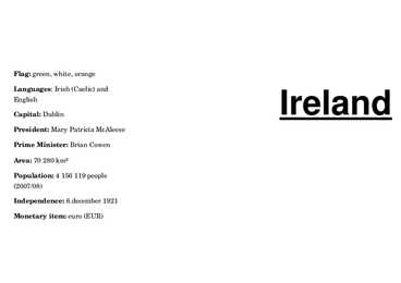
Flag: green, white, orange Ireland Languages: Irish (Caelic) and English Capital: Dublin President: Mary Patricia McAleese Prime Minister: Brian Cowen Area: 70 280 km² Population: 4 156 119 people (2007/08) Independence: 6.december 1921 Monetary item: euro (EUR) Ireland is the second biggest island in Sights: Malahid Castle; Howth the Drink: Irish coffee is one of the best the Europe. It is washed and ritch peole live there; rocks; sea; coffees in the world. influenced by the Atlantic Ocean in Temple Bar for tourists only; Trinity the west and the Irish Sea in the College it has very old library. east
.....9 Materials.................................................................................................................... 11 3 Introduction The United States of America is an enormous country. It is the third largest in the world after Russia and Canada. In the USA there are 50 states of which 48 lie together. The population of The USA is about 300 million people. The territory is about 10 million square kilometers. Its geography is very diverse ranging from moist rainforests to dry deserts and bald mountain peaks. There are two big mountain ranges, one of them is the Rocky Mountains and the other is The Appalachian Mountains. The Capital of The USA is Washington D.C. Other big and famous cities are New York, Los Angeles, Houston, Chicago and Las Vegas. The national anthem of the United States is "The Star-Spangled Banner", with lyrics written in 1814 by Francis Scott Key. There are 6 time zones
The United Kingdom The United Kingdom consists of England, Scotland, Wales and North Ireland and it is situated in the Atlantic Ocean near the mainland of Europe. The population of the UK is 58.6 million and area is 244,110 sq km. Britain has a temperate humid climate. Its characteristic features are mild winters, warm summer, no temperature extremes, abundant rain all year round and frequent changes of weather. The mild climate is partly due to the warm Gulf Stream and partly to the south westerly winds. Occasional winds from the east in winter may bring cold and dry weather. The distribution of rainfall is influenced by the Atlantic Stream. The mountainous areas of the north and west have more rain than the lowlands of the south and east. Wales is located on a peninsula in central-west Britain. The entire area of Wales is about 20,779 km². Wales borders by England to the east and by sea in the
Scotland ! Scotland (Gaelic: Alba) is a country in northwest Europe that occupies the northern third of the island of Great Britain. It is part of the United Kingdom, and shares a land border to the south with England. It is bounded by the North Sea to the east, the Atlantic Ocean to the north and west, and the North Channel and Irish Sea to the southwest. In addition to the mainland, Scotland consists of over 790 islands including the Northern Isles and the Hebrides. Edinburgh, the country's capital and second largest city, is one of Europe's largest financial centres. It was the hub of the Scottish Enlightenment of the 18th century, which saw Scotland become one of the commercial, intellectual and industrial powerhouses of Europe. Scotland's largest city is Glasgow, which was once one of the
Report of SCOTLAND Maiki Joakit 10. klass 2008 Etymology Scotland is from the Latin Scoti, the term applied to Gaels. The Late Latin word Scotia (land of the Gaels) was initially used to refer to Ireland. By the 11th century at the latest, Scotia was being used to refer to (Gaelic-speaking) Scotland north of the river Forth, alongside Albania or Albany, both derived from the Gaelic Alba. The use of the words Scots and Scotland to encompass all of what is now Scotland became common in the Late Middle Ages. History Repeated glaciations, which covered the entire land-mass of modern Scotland, have destroyed any traces of human habitation that may have existed before the Mesolithic period. It is believed that the first post-glacial
Ireland Ireland is a beautiful island that is washed and influenced by the Atlantic Ocean in the west.It is known for its gorgeous landscape, the green hillsides and the rocky coastline. Film-makers from all over the world have used the beautiful landscape of the island. Ireland is the third-largest island in Europe. It lies to the north-west of continental Europe. The population of Ireland is 6.2 million and there are two official languages English and Gaelic. Ireland `s capital is Dublin. The area of Ireland is 84,421 km2 Ireland is separated into two parts. The north is part of the United Kingdom, while four fifths of the island make up the Republic of Ireland, which has been an independent country since 1921. The Irish are fun-loving and friendly. They like music and humour and they are also good storytellers.
Tallinn English College Report of Canada 8a Teacher: Merike Sisask Composer: Kärt Kalvet 2010 Canada, Kärt Kalvet 8a Canada General Information Canada is in North America. It's area is 9220970 sq km. Canada's population is 313.612.000 people. Canada is divided into 10 provinces and 3 territories. The capital of Canada is Ottawa. Canada has constitutional monarchy. The head of state in Canada's government is the Queen of England. There are two main languages in Canada: English and French. Canada's curreny is Canadian dollar (1 dollar=100 cents[Can$]). The highest peak of Canada is Mount Logan, 5959 metres. The lowest point is sea level
Geography Canada is the world's second largest country in total area after Russia , since it covers nearly 10 million square kilometres, but is one of the most sparsely populated, with only about 34 million inhabitants. The majority of them live within 300 kilometres of Canada's southern border. Much of the rest of Canada is uninhabited or thinly populated, because the country has a rugged terrain and severe climate. Canada extends across the continent of North America, from Newfoundland on the Atlantic coast to British Columbia on the Pacific coast and northward into the Arctic Ocean. Canada shares land borders with the United States to the south and north-west. Canada is a land of great variety. Towering mountains, crystal-clear lakes, and lush, green forests make Canada's far west a beautiful region. Farther inland, fields of wheat and other grains cover Canada's vast prairies
The Republic of Ireland General overview Territory: 27,097 sq miles Population: 4 million Capital: Dublin Patron Saint: St Patrick The second largest of the British Isles 60 million people outside Ireland claim Irish ancestry Landscape and climate Ireland is low in the middle and high at its edges. Not very high mountains; highest is Carrantuohill (1,040 m) in the southwest At Moher, you can look 200m straight down into the sea Green fields, full of flowers, wide and empty beaches All landscape types are represented Climate is damp Ireland is one of the wettest countries in Europe History St Patrick converted the Irish to Christianity
Project ESTONIA MAP OF ESTONIA Southern Viljandimaa The southern part of Viljandi county catches the eye with its sublime scenery. The area today lies in the very heart of the historical Mulgimaa the home of hills, deep valleys and lakes brought together by a beauty spot Halliste primeval valley. According to several folk tales, it is also in these valleys, woods and bogs that Old Nick found refuge.The great variety displayed in the nature is also reflected in the local cultural heritage. At the beginning of the 19th century growing linen spread and became the basis
The capital city is Washington D.C. Although the United States has no official language at the federal level, English is the de facto national language. English is the most common language for daily interaction among both native and non-native speakers. Spanish is the second language. The largest city is the New York City. The Government is Federal constitutional republic and the president is George W. Bush. 2. Geographical position The United States of America is located on the continent of North America. It has borders with two countries Mexico and Canada. There are also the Atlantic Ocean, the Pacific Ocean and the Gulf of Mexico surrounding the big country. There are 50 states in America. Most of the people live in towns. The biggest state is Alaska; next by size are California, Alaska and Montana. Six states - Maine, Vermont, New Hampshire, Connecticut, Rhode Island and Massachusetts are called New England. They are all small states in the USA that lie in the north- east
Ireland Ireland (Irish: Éire, Irish pronunciation:) is a country in north-western Europe. The modern sovereign state occupies about five-sixths of the island of Ireland, which was first partitioned on 3 May 1921. It is bordered by Northern Ireland--part of the United Kingdom--to the north, by the Atlantic Ocean to the west, the Irish Sea to the east and the Celtic Sea and St George's Channel to the South and South-East. The legal name of the state is simply "Ireland", but its legal description the Republic of Ireland is sometimes used to differentiate the state from the island. On 29 December 1937 Ireland became the successor-state to the Irish Free State, itself established on 6 December 1922. Ireland was one of the poorest countries in Western Europe and had high emigration
'ledsltv 'sembl/ seadusandlik kogu The British Isles is the name of a group of islands washed by the North Sea in the east and the Atlantic Ocean in the west. The British Isles are shared by two separate and independent countries: the
cultural diversity of different nations in Canada. All the communities living in the country are encouraged to remember their origins and hold their own ethnic events and national festivals. Cultural diversity makes Canada even more interesting. In spite of this, in recent years there is a strong movement in French-speaking Quebec to become an independent country. There are many different native people throughout Canada like the Crees, Mohawks, Troquois and Sioux. In the north of the country, the Inuit (Eskimos) now have a self-governing homeland called Nunavut, meaning our land. It is over two million square kilometers and it is inhabited by 17,500 Inuits. The national symbol of Canada is the maple leaf. The national tree is the maple. Canada is also the most tolerant societies in the world because only 13% of Canadians say that they would object their children marrying somebody of a different race, compared with 32% in the USA.
1) General facts The UK: * the United Kingdom of Great Britain and Northern Ireland was formed in 1801 * it covers 243,610 sq km * everybody from the UK is called British * the capital city is London * is made up of four constituent countries: England, Scotland, Wales and Northern Ireland which in turn are divided into counties * the flag is called the Union Jack which is a combination of the flags of England, Scotland and Northern Ireland * the population is about 60,000,000 people, the population density is 242 people/sq km * its coasts are washed by the Atlantic Ocean, the North Sea, the English Channel, the Celtic Sea, Saint George's Channel, and the Irish Sea. It is linked to France by the Channel Tunnel * the United Kingdom is a constitutional monarchy. The current monarch is Queen Elizabeth II, who is also the Queen and Head of State of fifteen other Commonwealth Realms, such as Canada, Australia, New Zealand and Jamaica.
6. Towns, economy, agriculture 7. Climate 8. Animals, plantlife 9. Population 10. Sports 11. Culture 12. History 13. Political system, symbols 14. Conclusion 15. Materials 1. Introduction If you had to use two words to describe Canada, they might be large and diverse. Canada is the second largest country in the world, bordered by three oceans, and across the country, Canadians experience many different landscapes from rolling plains and mountains to the cold tundra of the north. Despite Canada's great size, it is one of the world's most sparsely populated countries. This fact, coupled with the grandeur of the landscape, has been central to the sense of Canadian national identity. 2. Geographical position Canada is the second largest country in the world after Russia. In the Arctic, Canada reaches almost as far north as Greenland. To the south it extends to the same latitude as southern France. The distance from Canada's west coast, the Pacific Ocean, to its
white and represent the Thirteen Colonies. The 50 small, white stars represent the 50 U.S. states. The U.S. flag is commonly called ,,the Stars and Stripes". The Statue of Liberty, that is locatd in New York,is a gift from the France. The Libety Bell, that is a bronze bell that symbolizes freedom in the United States of America. It is located in Pennsylvania,U.S. Capital: Washington D.C Biggest city: New York National language: English Location U.S is located in North America, bordering both the North Atlantic Ocean and the North Pacific Ocean. United States neighbour countries are Canada and Mexico. The USA has the 8th longest coastline in the world at ~20 000 km. 62% of the perimeter of the USA is coastline. The USA's coastline is made up of beaches, cliffs, mangroves, and urban and developed areas, which make America very versatile country. Political division United States of America distributes into 50 states
THE U.K Different Parts The United Kingdom is a short way of saying the United Kingdom of Great Britain and Northern Ireland. The UK is the political name for those countries which share a parliament in London. All of them were at one time independent kingdoms with their own monarch. Now they are all part of the same kingdom and share the same monarch. The UK consists of Northern Ireland, Scotland, England and Wales. The peoples of these countries are British subjects; they hold British passports and therefore their nationality is British. The british Isles is the geographical name for all the islands off the west coast of Europe. These islands also include The Republic of Ireland, which is politically independent of the Britsh government. Many people refer to the inhabitants of the British isles as 'the English', but England is only one of the countries
FACTFILE Area: 45 228 sq km Poplulation: under 1.4 million Capital: Tallinn Language: Estonian Currency: Eesti kroon (EEK) Main religion: Lutheran National holiday: 24 February (anniversary of the republic) National flower: Cornflower National bird: Barn Swallow National stone: Limestone LOCATION The Republic of Estonia is the northernmost and smallest of the three Baltic States. It is located on the eastern shores of the Baltic Sea in the north east of Europe. To the east the country borders Russia. Latvia is the countries neighbour to the south. From the west the coast of Estonia is washed by the Baltic Sea and from the north by the Gulf of Finland. The length of the coastline is approximately 3 800 km. The longest distance from east to west is 350 km, while north to south Estonia stretches 240 km. THE NAME The name EESTI was apparently derived from the word AISTI, the
Western Australia , South Australia, The Australian Capital Territory and the Northern Territory). The Australian people are culturally the same as the Anglo Americans. There also live aborigines. Aborigines are the ancestors of the people. Like the US and Canada, Australia was an English speaking colony of Great Britain. Today Australia is a modern developed country with a diversified economy. Australia is an island continent of 7.7 million square kilometres, which makes it a little smaller than the USA. Located in south of Asia, between The Pacific and Indian Oceans, Australia is the World's driest continent. Although large areas of the centre are desert, Australia has a wide range of climate from tropical in the north to temperate in the south east, where it frequently snows in winter. Geographical position The coasts of Australia are surrounded by the Pacific Ocean, the Indian Ocean and the
CANADA Canada is a vast country, second largest country of the world after Russia. It stretches from the Atlantic Ocean in the east to the Pacific Ocean in the west and to the Arctic Ocean in the North. Canada Covers most of the northern part of North America and its geography is very diverse. Canada's area is about 10 million square kilometers and its population is 31 000 000. Its capital is Ottowa and other main cities are Toronto, Montreal and Vancouver. Almost 75 % of canadians lives within 300 kilometer of the USA border, because the climate is softer in the South. 89 % of Canada is almost unhabited. Its official languages are English and French, but many other languages are spoken too. Like Italian, Chinese, German, Polish, Ukrainian,
Alberta The capital of Alberta is Edmonton. The population is 3.7 million people and there are many nationalities. Besides English and French there are also immigrants from Scotland, Ireland, Wales, Germany, Ukraine and Scandinavia. In Edmonton and Calgary there are also historic Chinatowns, and Calgary has Canada's third largest Chinese community. Geographical features Alberta covers an area of 661,848 square kilometres, an area about 5% smaller than Texas or 20% larger than France. This makes it the fourth largest province after Quebec, Ontario, and British Columbia. To the south, the province borders on the 49th parallel north, separating it from the U.S
About Estonia Estonia, officially the Republic of Estonia is a country in Northern Europe. Estonia has land borders to the south with Latvia and to the east with Russia. It is separated from Finland in the north by the Gulf of Finland and from Sweden in the west by the Baltic Sea. Average elevation reaches only 50 meters and the country's highest peak is the Suur Munamägi in the southeast at 318 meters.Estonia boasts over 1,400 lakes. Most are very small, with the largest, Lake Peipus, (Peipsi in Estonian) being 3555 km². There are many rivers in the country. The largest are the Võhandu (162 km), Pärnu (144 km), and Põltsamaa (135 km). Estonia also boasts numerous
and it is bordered by three oceans: the Arctic, the Pacific and the Atlantic Oceans. The population of Canada is about 31 million people. About 77% of the people live in cities which lie in a band about 100 miles wide above the border of the United States. The capital of Canada is Ottawa. Other large cities are Montreal, Toronto, Vancouver, Winnipeg and Quebec. 2. Geographical position Canada is a huge country in the continent of North America. It is bordered with the Atlantic Ocean in the east, the Pacific Ocean in the west, the United States of America in the south and the Arctic Ocean in the north. Canada is a vast country, with a territory of 3.8 million square miles of land and fresh water it is the second biggest country in the world after Russia. Canada covers most of the northern part of North America. Canada has over 151,480 miles of coastline
Johan Mähar Tartu 2008 Contents p. 1. Introduction....................................................................................................1 2. Nature and geography.....................................................................................2 3. Position and size.............................................................................................2 4. Climate............................................................................................................3 5. Flora and fauna...............................................................................................4 6. Main fields of economy and industry..........................
República Portuguesa) is a country located in Southwestern Europe, on the Iberian Peninsula. It is the westernmost country of mainland Europe, and is bordered by the Atlantic Ocean to the west and south and by Spain to the north and east. The Atlantic archipelagos of the Azores and Madeira are Portuguese territory as well. The country is named after its second largest city, Porto, whose Latin name was Portus Cale. SETTLEMENT The land within the borders of the current Portuguese Republic has been continuously settled since prehistoric times. In the 8th century most of the Iberian Peninsula was conquered by
Võnnu Keskkool ESTONIA Referaat Autor: Klass : 9 Juhendaja: Võnnu 2013 Estonia officially the Republic of Estonia, is a state in the Baltic region of Northern Europe It is bordered to the north by the Gulf of Finland, to the west by the Baltic Sea, to the south by Latvia and to the east by Lake Peipus and Russia.Across the Baltic Sealies Sweden in the west and Finland in the north. The territory of Estonia covers 45,227km2 The Estonian climate resembles that of other countries on the Baltic littoral. On account of the country's proximity to the sea, the skies are often cloudy, and rain often falls in the spring and autumn, in the winter the rain turns to snow. The highest point in Estonia is Suur Munamäg It is in fact the highest point in the Baltic region Forest cover over one half of Estonia. The most common types of tree are pine, spruce and birch
There are usually about 10 signs or more on one post , and its really hard to see them when driving, so tourists disturb traffic quite often when slowing down to read the signs All the signs are multilingual ,due to high percentage of English speakers Forests Ireland has only about 8 % of his whole land covered with forests. Centuries ago people cut the forests and didn't think about the future so nowadays there is mostly peat ( turvas) which Ireland uses to produce energy. Economy Ireland had a big economic boom in the late 20'th century, but now the Republic of Ireland is ranked the second wealthiest per capita country in the European Union. Education in Ireland is free at all levels, including college. The construction sector, which is inherently cyclical in nature, now accounts for a significant component of Ireland's GDP. ( ehitus/tõõstus sektor, mis on loomupäraselt tsükliline , mängib nüüd
NEW ZEALAND Geography: New Zealand is situated midway between the Equator and the South pole in the southern Pacific Ocean. It consists of two large islands, North Island and South Island, plus several smaller ones of which Stewart Island is the largest. North and South Islands are separated by the 32km wide Cook Strait. The total land area is 270,535 sq Km, about the size of Italy, the United Kingdom or the US state of Colorado. North Island is volcanically active with three active volcanoes. South Island has the high snow covered mountain peaks and glaciers of the Southern Alps, a range running almost 500Km along the Island. The longest river is the Waikato on North Island (425 Km), the largest inland stretch of water is Lake Taupo also on North Island (607 sq Km) and the highest point is Mount Cook on South Island (3754 m). Over 75% of New Zealand is above 200m.