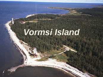
Vormsi Island Location Located between Hiiumaa and the mainland Fourth largest Estonian island Covering 92 square kilometres The meaning of "Vormsi" Known as "snake island" Derived from the German name "Worms" or it's Swedish name "Ormsö", both meaning snake island History Vormsi was inhabited by coastal Swedes 2500 people lived there before WWII During the Soviet occupation Vormsi was a closed border-zone Blend of Soviet and Swedish history mixed with unspoilt nature Nowadays Celtic crosses from the 13th century in Vormsi cemetery Vormsi is for people interested in mixed Soviet and Swedish history and rare nature Landscape Juniper fields Seaside meadows Erratic borders Lighthouses Forests Bays Lagoons
It is the ninth largest island in the world, the largest European island and the largest of the British Isles. With a population of about 60.0 million people in mid-2009, it is the third most populous island in the world, after Java and Honsh. Great Britain is surrounded by over 1,000 smaller islands and islets. The island of Ireland lies to its west. The capital of England is London and its official language is English. The island was first inhabited by people who crossed over the land bridge from the European mainland. Traces of early humans have been found from about 500,000 years ago. Until about 10,000 years ago, Great Britain was joined to Ireland. When visiting the capital London a tourist should go sightseeing around the city. There are lots of attractions to look out. For example the famous Big Ben is a huge tourist magnet or The Eye as well, where people go and enjoy the view. Also many museums in London give
IRELAND Ireland is a very beautiful island in the Atlantic Ocean. That lays next to Great Britain. This island is gorgeous landscape, the green hillsides and the rocky coastline. Ireland weather is influence of the Gulf Stream, there is warm and rainy through the year. The Celts inhabited the land. Ireland is separated into two parts. The north part (smaller) is part of the United Kingdom, bigger part of island makes up Republic of Ireland (independent country). The population of the Republic of Ireland is about three and half million people. There are two official language- English and Gaelic. Mostly there is used English. The Irish are know as friendly and fun-loving people. They like music and humor. In Ireland the most popular legend is about the leprechaun
Sustainable city planning Sandra Erik 11L What is sustainable city planning? • A sustainable city, or also know as eco-city, is a city designed with consideration of environmental impact, inhabited by people dedicated to minimization of required inputs of energy, water and food, and waste output of heat, air pollution - CO2, methane, and water pollution. • It should meet the needs A sustainable city should be able to... • feed itself with minimal reliance on the surrounding countryside, and power itself with renewable sources of energy. • create the smallest possible ecological footprint • produce the lowest quantity of pollution possible
The tallest are 12 metres tall. Snowdonia national park Location: north Wales. The highest mountain is Snowdon which is 1085 metres tall. The national park covers 2140 square kilometres. The park has about 6 million visitors every year. Windsor Castle Location: Berkshire. The original castle was built in the 11th century. It was designed to protect Norman dominance around London. It's the largest inhabited castle in the world. In 1992 there was a fire in the castle about 100 rooms were damaged. Edinburgh castle Location: Edinburgh, Scotland. It's built on the Castle Rock. The castle has been used residentially and militarily. It's Scotlands most visited tourist attraction, it had 1,2 million visitors in 2011. Thanks for listening!
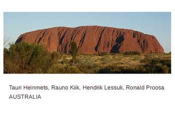
Tauri Heinmets, Rauno Kiik, Hendrik Lessuk, Ronald Proosa AUSTRALIA Geographical position Australia is a country in the Southern Hemisphere comprising the mainland of the Australian continent as well as the island of Tasmania and numerous smaller islands in the Indian and Pacific Oceans. world's sixth-largest country by total area. The lowest point in the country is lake of Eyre (15m below sea level) and the highest point is Mount Kosciuszko (2229m) Economy Mixed economic system Division of labor Agriculture 3,6%; Industry 21,1%; Tendance 75% Units of labor 11,45 mlj. 2009. Unemployment 5,6% Most important export articles: coal, iron,gold Most important import articles: machinery and transport equipment Australia is one of the most important mining industry countries Politics Capital: Canberra Largest city: Sydney National language: English (de facto) Demonym:Australian, Aussie Government: Federal parliamentary c...
Fair Trade Tourism Local people have often been the last to benefit financially from international tourism. But this is slowly changing. It's happening in Vietnam. The first tourists can see many famous war sites, towns and vibrant green paddy fields. But if they go up into the hills they find a region inhabited by hill tribe people, who live basic, subsistence life. Local people are looking at tourists with fear and disdain. In the villages children are playing and mothers with elaborate headdresses are getting on their daily lives, but if tourists come, they run indoors and villages become silent. In Thailand hill tribe treks have become infamous ,,human zoos". Tourists from all over the world traipse through the villages and this causes cultural and economic disaster
Prehistoric Britain · They built forts on hilltops and · When the English Channel was pro-tected them with ditches and formed by meltic ice(around 6000 BC), ramparts. Britain was part of the European land mass. · The earliest inhabitants lived in limestone caves. · About 3000 BC the British Isles were inhabited by a people as known as the Iberians. · Celts and Iberians both lived under · They used stone axes and made the primitive system: there was no antlers and bones into leather-working private property, no classes and tools. exploitation. · Inhabitants put up buildings of
When a peace agreement was reached in 304 BC, the Antagonids lifted the siege, leaving a wealth of military equipment behind. The Rhodians decided to express their pride by building a triumphal statue of their favourite god, Helios. The task was assigned to the sculptor Chares of Lindos, a pupil of Lysippos himself, and twelve years (from 304 to 292 BC) were needed to complete it. The Colossus of Rhodes was not only a gigantic statue. It was a symbol of unity of the people who inhabited that beautiful Mediterranean island of Rhodes. To build the statue, the workers cast the outer bronze skin parts. The base was made of white marble, and the feet and ankle of the statue were first fixed. The structure was gradually erected as the bronze form was fortified with an iron and stone framework. To reach the higher parts, an earth ramp was built around the statue and was later removed. When the Colossus was finished, it stood about 33 metres (110 ft) high.
6,435 kilometres. Chile expanded in the late 19th century, when it incorporated its northern and southern regions. Southern Chile is rich in forests and grazing lands and features a string of volcanoes and lakes. The southern coast is a labyrinth of fjords, inlets, canals, twisting peninsulas, and islands. Prior to the coming of the Spanish in the 16th century, northern Chile was under Inca rule while the indigenous Araucanians inhabited central and southern Chile. Although Chile declared its independence in 1810, decisive victory over the Spanish was not achieved until 1818. Currently, Chile is one of South America's most stable and prosperous nations. The national flower is the copihue (Chilean bellflower), which grows in the woods of southern Chile. The coat of arms depicts the two national animals: the condor and the huemul. Chile's most popular sport is association football Chile has appeared in seven FIFA World
The Republic of South Africa History The Republic of South Africa is a country located at the southern tip of Africa, with a 2,798 kilometres coastline on the Atlantic and Indian Oceans. Modern humans have inhabited Southern Africa for more than 100,000 years. In 1652 the Dutch East India Company founded a refreshment station at what would become Cape Town. The discovery of diamonds and later gold triggered the conflict known as the Anglo-Boer War, as the Boers and the British fought for the control of the South African mineral wealth. Although the Boers were defeated, the British gave limited independence to South Africa in 1910 as a British dominion. South Africa contains some
Doctor Bird is a long-tailed hummingbird. The Blue Mahoe (Hibiscus elatus) is the national tree of Jamaica. National Dish Ackee fruit Ackee Flower Ackee oil makes an important contribution to the diet of many Jamaicans. Jamaican dollar The dollar has been the currency of Jamaica since 1969. It is divided into 100 cents. The history Jamaica was inhabited by Arawak Indians when Columbus explored it in 1494 and named it St. Iago. Traditions New Year's Day in Jamaica is a grand celebration time with festive parties and colorful fireworks shows. Famous "Johnkankus" parades and masquerades mark is an age-old New Year tradition of Jamaica. Interests Jamaicans, in general, have a large interest in sports. Cricket, Football (soccer), athletics and horse-racing are
around 1,770 kilometres northeast of Miami, Florida, and 1,350 kilometres south of Halifax , Nova Scotia, Canada. The nearest landmass is Cape Hatteras, North Carolina, about 1,030 kilometres west-northwest. It is the oldest and most populous remaining British overseas territory, settled by England a century before the Acts of Union created the United Kingdom of Great Britain. Bermuda's first capital, St. George's, was settled in 1612 and is the oldest continuously inhabited English town in the Americas. Although commonly referred to in the singular, the territory consists of approximately 138 islands, with a total area of 53.3 square kilometres. Compiling a list of these islands is often complicated, as many have more than one name (as does the entire archipelago, which, in addition to its two official names, has historically been known as "La Garza," "Virgineola," and the "Isle of Devils"). "St. George's Parish (each known as St. George's),
The capital city is Nashville, and the largest city is Memphis. Tennessee has 95 counties. The earliest variant of the name that became Tennessee was recorded by Captain Juan Pardo, the Spanish explorer, in 1567 while traveling inland from South Carolina. History The area now known as Tennessee was first settled by Paleo-Indians nearly 11,000 years ago. When Spanish explorers first visited the area (led by Hernando de Soto) in 15391543, it was inhabited by several tribes (Muscogee, Yuchi people). As European colonists spread into the area, the native populations were displaced to the south and west. Many battles were fought in the state, for example in 1862 and 1863. Symbols The official state flag of Tennessee was adopted on the 17th of April in 1905. The three white stars in the center symbolize the three different geographical regions of Tennessee. The white circle binds them together
MARYLAND FACTS The United States Naval Academy was founded at Annapolis. The first dental school in the United States opened at the University of Maryland. Babe Ruth, the Sultan of Swat, was born in Baltimore and attended Saint Mary's Industrial School. The National Aquarium is located in Baltimore's Inner Harbor. Annapolis is known as the sailing capital of the world. Located in the Chesapeake Bay, Smith Island is Maryland's only inhabited off-shore island. FUN LAWS Persons may not swear while on the highway. It is a park rule violation to be in a public park with a sleeveless shirt. It's illegal to take a lion to the movies. No person who is a "tramp" or "vagrant" shall loiter in any park at any time. You may not curse inside the city limits. It is illegal to use profane language on a playground. Knocking stones into a public park is prohibited.
infinitive he's going to go Present Simple Passive Past Simple Passive Am/is/are + III põhivorm/-ed was/were + III põhivorm/-ed Estonia is inhabited mostly by Estonians and Russians This house was built 7 years ago
called Reval for some time and finally Estonians started to call the town Tallinn from Taanilinn (Danish town) after the Danish conquest in the 13th century. The Knights of the Sword took Tallinn from the Danes in 1227 and made Toompea their fortress. In the middle of the 14th century Denmark sold its possessions in Estonia to the German Teutonic Order; Toompea became the seat of German-born gentry. A fortified wall was built between the Toompea (the Upper Town) and the Lower Town (inhabited by people of a lower social standing), as there were conflicts between the two. The doors and the gates of the wall were locked at night, a procedure which carried on until the end of the 19th century. Tallinn joined the German-dominated Hanseatic League in 1285 and became a junction of trade between East and West: furs, honey, leather and seal fat moved west, while salt, cloth, herring and wine moved 'in the opposite direction. As salt was an
1. Where's A. situated? Auckland is situated in the Nort Island of New Zealand. 2. What's the population of A? It's the home of more than 400,000 people in Auckland City, that's 32.4% of the national population. 3. What kind of city is it? It is the biggest city of New Zealand, and it's waterside location has fostered the locals love affair with the sea, earning this place the nickname "City of Sails". 4. Who inhabited the city first? The first sailors to settle here were the Maori, and in later years migrants from the Pacific Islands have contributed to the Polynesian population. 5. When did the Europeans come? Europeans setteled in Auckland in 1840, a thousand years after Maori's did. 6. What kind of centre is Auckland? Auckland is the center of sails. 7. What are its most famous sights? Describe them. Famous landmarks such as the Sky Tower and Cornwall Park and One Tree Hill get
The local climate is tropical and generally hot and humid. The major religions in Guyana are Christianity, Hinduism, Islam and other minor different faiths. Most Guyanese Christians are Protestants and include a mix of all races. Hinduism is dominated by the Indians who came to the country in the early 1800s, while Islam varies between Afro-Guyanese and Indian-Guyanese. When the first Europeans arrived in the area around 1500, Guyana was inhabited by the Arawak and Carib tribes of American Indians. Although Guyana was first sighted by Christopher Columbus during his third voyage in 1498. In 1831 the three separate colonies became a single British colony known as British Guiana. Escaped slaves formed their own settlements known as Maroon communities, but with the abolition of slavery in 1834 many of the former slaves began to settle in urban areas.
Northern Ireland. The state flag of the Republic of Ireland is the Tricolour. The history of the Irish Tricolour bearing the colours green for the Catholic majority, orange for William of Orange the Protestant King (and his followers) and white for the desired peace between them, goes back to the middle of the 19th century.[11] History Ireland was mostly ice-covered and joined by land to Britain and continental Europe during the last ice age. It has been inhabited for about 9,000 years. Stone age inhabitants arrived sometime after 8000 BC. Irish Independence: The Irish Free State, Éire, Ireland The state was neutral during World War II which was known internally as The Emergency, but offered some assistance to the Allies, especially in Northern Ireland. Indeed, more than 60,000 volunteers from the Republic fought in the British armed forces [3]. In 1949, the state declared itself to be a republic and that
Pope leads a torchlit "Way of the Cross" procession to the amphitheatre.[5]The Colosseum is also depicted on the Italian version of the five-cent euro coin. History Construction of the Colosseum began under the rule of the Emperor Vespasian in around 70 72AD. The site chosen was a flat area on the floor of a low valley between the Caelian, Esquiline and Palatine Hills, through which a canalised stream ran. By the 2nd century BC the area was densely inhabited. It was devastated by the Great Fire of Rome in AD 64, following which Nero seized much of the area to add to his personal domain. He built the grandiose Domus Aurea on the site, in front of which he created an artificial lake surrounded by pavilions, gardens and porticoes. The existing Aqua Claudia aqueduct was extended to supply water to the area and the gigantic bronze Colossus of Nero was set up nearby at the entrance to the Domus Aurea
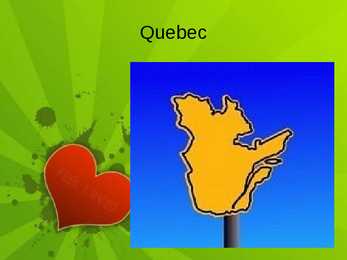
90% of Quebec's territory lies within the Canadian Shield The Eastern Canadian forests cover the Appalachian Mountains Climate Most of central Quebec has a subarctic climate. Winters are long, very cold, and snowy. Summers are warm but very short. History At the time of first European contact and later colonization, Algonquian, Iroquoian and Inuit tribes were the peoples who inhabited what is now Quebec. Hélène Desportes, born July 7, 1620, to the French habitants (settlers) Pierre Desportes and his wife Françoise Langlois, was the first child of European descent born in Quebec. The Quiet Revolution from 1944 to 1959 was a period of dramatic social and political change Population In 2006 the population of Quebec was 7,546,131 people Canadian 4,474,115 people60.1% French 2,151,655 people 28.9% Irish 406,085 people 5
Canada's History North America was first settled by people who came from the northern and eastern parts of Asia about 15,000 years ago. They crossed the Bering Strait from Siberia to Alaska. Some of those people followed the Yukon River and found their way south. Others followed the MacKenzie River which opened the way to the plains of the interior, and then travelled on to the Great Lakes and the St. Lawrence River. The third group of people inhabited the Arctic regions. The first two groups were called Indians, the group that settled in the north were called Eskimos. These people are the only true native Canadians, the rest are new Canadians who have been transplanted from other parts of the world, especially from Europe. The first European visitors to North America were Norsemen who settled briefly in the 11th century. John Cabot, a Venetian seeking riches for England, made the next known voyage in 1497
strongholds, homes, and historic sites throughout the years. While some tourists come to see the castles England features as the primary focus of their Europe vacation, other travelers hope to visit the castles England has as part of a larger trip. No matter what your particular focus, castles in England are one of the most impressive attractions in England. http://www.youtube.com/watch?v=VoXFfvVj6WQ Windsor Castle Windsor Castle is the largest inhabited stronghold in the world as well as the largest castle to be found in England. Windsor castle is a favorite residence of the current royal family, and has served the purposes of the monarchy since the days of William the Conqueror. Tours of the castle are available daily. The Tower of London Being situated along the River Thames in the heart of London, this castle is one of England's best known. It was established just after William the Conqueror arrived in 1066 of our Common Era
Australia Kaspar Rätsep G1A Australian nature · Australian nature is extremely diverse and interesting. It's the driest inhabited continent, only its south-east and south-west corners have a temperate climate. · The climate of Australia is significantly influenced by ocean currents, which is correlated with periodic drought, and produces cyclones in northern Australia. · Much of the northern part of the country has a tropical summer rainfall (monsoon) climate. The southwest corner of the country has a Mediterranean climate. Much of the southeast is temperate.
Valley in California with 86 m below sea level is the lowest point on the continent. Yellowstone National Park is one of the most visited natural attractions in the United States. Founded way back in 1872, Yellowstone is the oldest national park in the world and covers territory in three states, namely Idaho, Montana and Wyoming. The park is not only famous for its geysers and other volcanic attractions but also for its richness of wildlife including bears and herds of buffalos. Once inhabited the present United States from Coast to Coast original Native (Indian) Americans. Indians, the name commonly applied to the people found by Columbus in America. They introduced colonists to clothing such as moccasins and ponchos, as well as to cotton, which is used to make many clothes today. Much of early Indians' clothing was made from deer skins. Many common English words have American Indian origins. These include:
veebilansiga ala); 6. segametsade vööndile omane mullastik, taimestik ja taimkate, samuti loomastik (flooras ja faunas esineb võrdlemisi palju lääne päritoluga liike); 7. inimtegevuse oluline mõju nüüdismaastike kujunemisel. Raukas, A., Teedumäe, A. (eds). 1997. Geology and Mineral Resources of Estonia. Estonian Academy Publishers, Tallinn. 436 pp. Photo 62. Lammasmägi Hill near Kunda. About 8500 years ago its surroundings were inhabited by hunters and fishers who lived in small clan communities and gave a name to the well-known Mesolithic Kunda Culture. Photo by G. Baranov. Inimese loodusesse sekkumise olulisemad algusajad (Arold, jt 1987 järgi) Aineringet mõjutanud inimtegevus Algusaeg Maaviljelus Alepõllundus ~3000 a.t.; Künni laiendamine 17.saj.
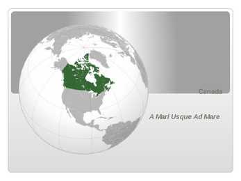
consisting of ten provinces and three territories located in the northern part of the continent, it extends from the Atlantic Ocean in the east to the Pacific Ocean in the west, and northward into the Arctic Ocean spanning over 9.9 million square kilometers, Canada is the world's second largest country by total area its common border with the United States is the longest land border in the world. Some facts The land that is now Canada was inhabited for millennia by various groups of Aboriginal peoples beginning in the late 15th century, British and French France ceded nearly all of its colonies in North America in 1763 after the Seven Years' War Historical Background in 1867, with the union of three British North American colonies through Confederation, Canada was formed as a federal dominion of four provinces this began an accretion of provinces and territories and a process of
the east and south-east by Russia, in the south by Latvia and in the west by Võru County. The greatest extent from north to south is 65 km and from east to west 40 km. Today Setomaa is divided between three administrative units: Võru and Põlva counties of Estonia and Pechorsky district of Russia. On the territory of Estonia, Setomaa comprises four municipalities: Misso, Meremäe, Värska and Mikitamäe municipalities. According to the latest archaeological finds the area of Setomaa has been inhabited for as long as 8 400 years.The ancestors of the people speaking the Võro-Seto dialect belonged to the Balto-Finnic eastern tribes. In old chronicles they have been mentioned probably under the name of the Chudes. Seto people are their lineal descendants. In 1920, the Treaty of Tartu between the Republic of Estonia and the Russian Federation was concluded. According to the Treaty, Setomaa was linked with Estonia. The folk have divided Setomaa into twelve parts, or communities (nulk)
where sacrifices to the sea were made in the old times. · The Field of the Kaali Meteorite Craters in Central Saaremaa is the rarest nature remembrance in Estonia, being at the same time also the most impressive field of craters in Eurasia. The biggest crater has a diameter of 110m and is 16 meters deep. There are eight craters found in the surrounding area. The Kaali Meteorite is the last (ca 7500 yrs ago) giant meteorite fallen to the densely inhabited area in the world. · he River Võhandu is the longest river in Estonia 156km, with its source in the Otepää Upland, near the Village of Sirvaste. The oldest part of the River from the Leevi Mill Dam to the Bridge of Reo is under natural protection. The protection area is 12km long and covers 300 meters of the landscape from each bank. Of the 38 outcrops in the protection area the biggest and most fascinating are Põdramüür (16
warns ships away from the shoreline. The height of the building itself is 36 metres, and the light is 102.6 metres above sea level, making it the highest coastal light on the Baltic Sea. 10. Kaali crater The meteorite crater field in Kaali, Saaremaa, is the rarest natural monument in Estonia as well as the most impressive crater field of the whole Eurasia. The Kaali meteorite was the last giant meteorite that fell in a densely populated region of the world. Its fall on the inhabited island of Saaremaa evidently caused extensive damage and possibly also numerous victims, it has been compared with an explosion of a small nuclear bomb. The fall of the meteorite was historically remarkable as an event and for its influences on human culture. 6
Visit 3 villages and 4 lookout points where you`ll get an amazing view over the lagoon. Your English-speaking guide will also take you to the historical site where US Army cannons remain from World War II. BORA BORA AQUA SAFARI WITH HELMET Go for a walk underwater with an air-supplied helmet and find yourself surrounded by tropical fish. This 2-hour excursion includes a boat tour of Bora Bora and snorkeling in the lagoon. History Prior to European contact, the island was inhabited by Polynesian settlers in the 4th century AD. Two clans, in particular, were in a constant struggle for power. Researchers believe that Bora Bora held the military power over all of the Leeward Islands. In the 1700's, Chief Puni ruled the island as well as clans on other islands including Tahaa, Raiatea, and Maupiti. European explorer, James Cook, landed on Tahaa and Raiatea in 1769 and on Bora Bora in 1770. Approximately 50 years later, the London Missionary Society began introducing
The archipelago is located between 176° 53 east and 178° 12 west. The 180° meridian runs through Taveuni but the International Dateline is bent to give uniform time to all of the Fiji group. With the exception of Rotuma, the Fiji group lies between 15° 42 and 20° 02 south. Rotuma is located 400 kilometres north of the group, 670 km from Suva, 12° 30 south of the equator. Fiji consists of 322 islands (of which 106 are inhabited) and 522 smaller islets. The two most important islands are Viti Levu and Vanua Levu. The islands are mountainous, with peaks up to 1,300 metres (4,250 ft), and covered with thick tropical forests. Viti Levu hosts the capital city of Suva, and is home to nearly three quarters of the population. Other important towns include Nadi (the location of the international airport), and the second city -Lautoka (the location of a large sugar mill and a seaport)
Today, the Maori have adopted western lifestyles but have actively been encouraged to keep alive their culture, language and art. Other ethnic groups have arrived from Polynesia (Tonga, Samoa, Cook Islands) with Auckland now being the Polynesia capital of the South Pacific. People from China, Taiwan, Korea, Vietnam, etc have also settled in New Zealand making for a diverse population mix. History : New Zealand was one of the last corners of the planet to be inhabited by people. Around 950AD the Maori arrived from Polynesia (Tonga and Hawaii) to the northern part of the North Island. There is however evidence of earlier settlement by other more peaceful Polynesian people. After the dutch sailor Abel Tasman visited New Zealand and named it Zeeland, more and more settlers arrived, conflicts over land led to several wars between the British and Maori in the North Island
law describes the flag as having dark green bunting with a state seal in the center. It is the only state flag that is green. It is also the only state flag with a picture of a president. Oregon · Oregon is a state in the Pacific Northwest region of the United States. Oregon is located on the Pacific coast between Washington to the north, California to the south, Nevada on the southeast and Idaho to the east. The area was inhabited by many indigenous tribes before the arrival of traders, explorers and settlers. · The Oregon Territory was created in 1848 after American settlement began in earnest in the 1840s. Oregon became a state (33rd) on February 14, 1859. · Oregon enjoys a diverse landscape including a scenic and windswept Pacific coastline, the volcanoes of a rugged and glaciated Cascade Mountain Range, dense evergreen forests, and high desert across much of the eastern portion of the state.
. Britain became an island only 5000 years BC after the Ice Age ended. Britain's prehistory The first evidence of human life on the island are dated back to 250 000 BC. 50 000 BC in a milder Ice Age period Britain became habitable again. People from that time were the ancestors of the modern British. 10 000 BC ige age ended and Britain became inhabited by small groups of hunters who probably followed herds of deer. 5000BC Britain became an island and deer died out. 3000BC the Neolithic people came (probably from Spanish peninsula or even North African coast). They may be the forefathers of the people from Cornwall and Wales. The building of Stonehenge started around that time. 2400BC the 'Beaker' people arrived in Britain. They had better metal working skills and they soon became the leaders of the British society
Tallinn English College CANADA Report Karin Kristen Tapupere 8.b Instructor: Tiiu Martma Intro: Canada is a country occupying most of northern North America, extending from the Atlantic Ocean in the east to the Pacific Ocean in the west and northward into the Arctic Ocean. It is the world's second largest country by total area and its common border with the United States to the south and northwest is the longest in the world. The land occupied by Canada was inhabited for millennia by various groups of Aboriginal people. Beginning in the late 15th century, British and French expeditions explored, and later settled along, the Atlantic coast. France ceded nearly all of its colonies in North America in 1763 after the Seven Years' War. In 1867, with the union of three British North American colonies through Confederation, Canada was formed as a federal dominion of four provinces. It is a bilingual and multicultural
nations living in Canada. All the communities living on the country are encouraged to remember their origins and hold their own ethnic events and national festivals. Cultural diversity makes Canada even more interesting. There are many native peoples throughout Canadalike the Crees, Mohawks, Iroquis and Sioux. In the north of the Country, the Inuit (Eskimos) now have a selfgoverning homeland called Nunavut (meaning "our land"). It is over two million sq km and is inhabited by 17,500 Inuits. Canada is one of the most tolerant societies in the world. For example only 13 % of canadians say that they would object their children marrying someone from another race (compared with 32 % in the USA). Canada's political structure is independent constitutional monarhcy. And head of state is Elizabeth II, who is also the Queen of Great Britain. From 1759 to 1931 Canada was a part of the British Empire,but in 1931 they got an independence from Britain
"British". This is very annoying for the 5 million people who live in Scotland (the Scottish), the 2.8 million people in Wales (the Welsh) and 1.5 million in Northern Ireland (the Irish) who are certainly not English. However, the people from Scotland, Wales, Northern Ireland and England are all British. What makes the Scottish, Welsh, English and Northern Irish different from each other? About 2,000 years ago the British Isles were inhabited by the Celts who originally came from continental Europe. During the next 1,000 years there were many invasions: the Romans from Italy, the Angles and Saxons from Germany, Denmark and the Netherlands, the Vikings from Denmark and Norway, and the Normans from France. These invasions drove the Celts into what is now Wales and Scotland, and they remained, of course, in Ireland. The English, on the other hand, are the descendants of all the invaders, but are more Anglo-Saxon than anything else
Mild summers, cool winters, much rain on northwest coast. Warm and dry in summer, mild with some rain rest of the year on California coast. Inland Southwest mostly dry with warm summers and cold winters. Warm summers, cold winters, moderate precipitation on northeast and north-central but warmer. Alaska is extremely cold in winter and has spetacular glaciers. Hawaii is tropical. History Before Columbus came to the New World in 1492, the land were inhabited by Native Americans or Indians. After 1492, there was a struggle for land and domination in the New World. England defeated the Spanish navy in 1588. In 1607, it started its first successful colony in America, called ,,Virginia". That was where Captain John Smith met the beautiful Native american princess, Pocahontas. The colonies grew fast, they became the main colonies in the Americas. From 1754 to 1761, Britain fought a war against the French and drove them out of North America
b) Famine is a serious problem, and it hasn't been dealt with yet c) Many kinds of wild animals need to be guarded by the law d) Living conditions have been made better in some parts of the world. e) Our local lake has been made dirty by nearby factories f) A problem which is not thought about does not simply go away g) A lot of people in industrial areas are without work h) After the recent storms, the town was filled with water i) Some countries are inhabited by too many people j) Recently the number of people riding bicycles has grown larger 5 Choose the most suitable word or phrase to complete each sentence. a) I'm glad I ....... my plane! I've just heard that it's broken down. A) lost B) refused C) missed D) altered b) The cruise ship hit a rock and ....... A) sank B) drowned C) flooded D) crashed c) I lost the keys to my house and had to climb in ....... the window. A) by B) to C) through D) with d) The village was completely ......
Heads were dipped in tar to provide protection from the elements, and at some point a collection of at least 30 heads was collected at the South gatehouse. Everyone from William Wallace of Scotland to Thomas Cromwell was displayed in the gatehouse, until the practice stopped in 1660 when King Charles II took power. Eventually, the houses on the bridge created a congestion that resulted in serious safety hazards. The houses and shops were no longer inhabited, and in the early 18th century a system of traffic was developed to maintain order on the busy structure. The mayor of London asked that bridge passengers travel in particular directions, creating the system of traffic that still remains in place in London today. The history of the London Bridge structure in place today began in 1967 and was opened by Queen Elizabeth II on March 17th, 1973. The modern bridge has sleek lines and is adorned with red lights. Guests travelling to
mammals, make underground burrows and hibernate until the spring or warmer weather arrives. When these animals hibernate their body temperatures can drop near freezing. Their hearts also slow so much that they are barely alive. Black bears also avoid the winter by sleeping in their dens. They go into a deep sleep and only wake up several times during the winter to leave their dens. Temperate grassland- Plants are also food for animals. Most temperate grasslands are inhabited by hares, mice, and other small rodents. These animals have sharp teeth that are able to easily gnaw through grass. Some of the familiar rodents found in the North American grasslands are prairie dogs, mice, rats, and ground squirrels. Prairie dogs are cute, burrowing rodents that live in underground communities. A dominant male heads a prairie dog family. They make their home in underground burrows that consist of several chambers and entrances
has been largely replaced by snowmobiles, cars and trucks. Some have central heating, electricity and plumbing systems in their houses; children go to school; and health service is provided by the government. There are many different native people throughtout Canada like the Crees, Mohawks, Troquois and Sioux. In the north of the country, the Inuits now have a selfgoverning homeland called Nunavut, meaning "our land". It is over two million square kilometers and it is inhabited by 17,500 Inuits. 9. Plants The flora of Canada is quite diverse, due to the wide range of ecoregions and environmental conditions present in Canada. From the warm, temperate broadleaf forests of southern Ontario to the frigid Arctic plains of the Northern Canada, from the wet temperate rainforests of the west coast to the arid deserts, badlands and tundra plains, the biodiversity of Canada's plants is extensive
national festivals. Cultural diversity makes Canada even more interesting. In spite of this, in recent years there is a strong movement in French-speaking Quebec to become an independent country. There are many different native people throughout Canada like the Crees, Mohawks, Troquois and Sioux. In the north of the country, the Inuit (Eskimos) now have a self-governing homeland called Nunavut, meaning our land. It is over two million square kilometers and it is inhabited by 17,500 Inuits. The national symbol of Canada is the maple leaf. The national tree is the maple. Canada is also the most tolerant societies in the world because only 13% of Canadians say that they would object their children marrying somebody of a different race, compared with 32% in the USA. Canada's political structure is independent constitutional monarchy and head of state is Elizabeth ll. The prime minister is Stephen Harpen.
wee bit hot, but do not fret as the sandy white beaches are available for you to cool off, with perhaps a cocktail or two. Or if you're into cold weather you can go in winter ( June to August) in which they offers skiing in NSW, Victoria and sometimes in Tasmania. However in time of spring and autumn the weather is perfectly gentle. Ancient Aboriginal culture - Australia is the world's oldest continent, inhabited for more than 40,000 years by Aborigines. It was settled by the British just over 200 years ago, in 1788, and since then has transformed from a colonial outpost into a nation with a population of more than 20 million. For visitors, its ancient, worn landscape contrasts with the vitality and youthful energy of its inhabitants. It is an ancient culture that is deeply connected to the land. At the heart of the continent is Uluru (named Ayers Rock by the colonial
Hill figures / hl 'fgs / künkajoonised, -figuurid Hill forts / hl f:ts / künkakindlused Fortification / f:tf'ken / kindlustamine Ditch / dt / kraav Bank of earth / bæk v : / mullavall There are no written records of Prehistoric Britain, the history is recorded in hill figures (pictures on mountains), hill forts like Hadrian´s wall and stone circles which were used as temples like Stonehenge. The priests were called Druids. Britain was inhabited by various peoples who later spread the Christianity through Northern England and Scotland. Roman Britain Nearing / nr / lähenev Wide-scale / wad skel / laia haardega Warlike / 'w:lak / sõjakas To overrun / v'rn / vallutama Bath / b: / saunakompleks, linnasaun Julius Caesar arrived in Britain in 55 BC and named this island Albion after the chalk cliffs on the southern coast. Britain became the Roman colony. They built roads, villas, public
There are deserts, semi deserts, grasslands, savannas, bushlands and rainforests. The wet forests occupy the narrow region in the east. Most of the animals, birds and insects live in that region, because there is enough food. The savannas which are grasslands with some trees are mostly in the west. Farther west are the bushlands. The real deserts occupy the centre of the Western Plateau. In the very south west there are thin forests of evergreens trees. Australia is the driest inhabited continent, the flattest, and has the oldest and least fertile soils. Only the south-east and south-west corners of the continent have a temperate climate. The northern part of the country, with a tropical climate, has vegetation consisting of rainforest, woodland, grassland, mangrove swamps and desert. Climate is highly influenced by ocean currents, including the El Niño southern oscillation. 4. Land regions Mountains The Great Dividing Range runs along the Pacific ocean
The area surrounding Aegviidu boasts a scenic landscape: the "Estonian Switzerland" is the bestknown skiing centre in North Estonia. Eastern Virumaa is an important industrial area which has many mines and ash hills. The county also has virgin forests, pre glacial valleys, beautiful lakes, bogs and attractive beaches. There is also Narva, the town on the border of Estonia and Russia, it is the easternmost and third largest town in Estonia. Kohtla Järve is an industrial toen inhabited by mostly Russian speaking people. Sillamäe was once closed to visitors because of the processing of rare metals and radioactive substances, it has now become an industrial centre and is considered one of the most pleasant towns in the county. Western Virumaa has a beautiful rural landscape, its highest being the hill of Emumägi. The Baltic glint is lower there and lies further away from the coast. Forests cover more than 40% of the county. The soil is very fertile for
[79] About 12 percent of American workers are unionized, compared to 30 percent in Western Europe. The U.S. ranks number one in the ease of hiring and firing workers, according to the World Bank Americans tend to work considerably more hours annually than workers in other developed nations, taking fewer and shorter vacations. 12. Biggest cities Seattle is the largest city in the state of Washington. It has been inhabited by humans for 4000 years. Major events in Seattle's history include the Great Seattle Fire of 1889, which destroyed the central business district but took no lives. In Seattle the climate is mild though it rains all the time. Living is very cheap, because government pays a lot. Five largest companies are in Seattle and there's also highest percentage of college graduators because schools try to have a racial balance. Los Angeles is often abbreviated L.A