Leidsid 33 sarnast õppematerjali, mis on seotud failiga "Bora Bora". Need materjalid aitavad sul teemat sügavamalt mõista.
bora, island, average, mount, tropical, round, month, year, mean, famous, deals, karus, 2018, such, first, weather, biodiversity, animal, inches, tourism, plane, links, tripadvisor, hotel, prezi, articles, attentionBora Bora Today the island is almost entirely dependent on tourism. Bora Bora, as you know is a paradise for honeymooners. This island offers blue skies, blue sea, golden sands and green flora. Vaitape is the largest city of island Bora Bora Some of the bigger industries on the island include deep-sea fishing, with exports going mainly to Japan, as well as mother-of-pearl and pearl production. Agricultural practices produce sugar, vanilla, rum, and copra (used to extract coconut oil). Despite all of these activities, tourism is by far the leading economic contributor. The island has several hotels to cater to tourists, including twelve 4 and 5-store places like Club Med, for example. 3
Australia Kaspar Rätsep G1A Australian nature · Australian nature is extremely diverse and interesting. It's the driest inhabited continent, only its south-east and south-west corners have a temperate climate. · The climate of Australia is significantly influenced by ocean currents, which is correlated with periodic drought, and produces cyclones in northern Australia. · Much of the northern part of the country has a tropical summer rainfall (monsoon) climate. The southwest corner of the country has a Mediterranean climate. Much of the southeast is temperate. · Climate change has become an increasing concern in Australia in recent years, with many Australians considering protection of the environment to be the most important issue facing the country. Australian nature · Eastern Australia is marked by the Great Dividing Range and
Western Australia , South Australia, The Australian Capital Territory and the Northern Territory). The Australian people are culturally the same as the Anglo Americans. There also live aborigines. Aborigines are the ancestors of the people. Like the US and Canada, Australia was an English speaking colony of Great Britain. Today Australia is a modern developed country with a diversified economy. Australia is an island continent of 7.7 million square kilometres, which makes it a little smaller than the USA. Located in south of Asia, between The Pacific and Indian Oceans, Australia is the World's driest continent. Although large areas of the centre are desert, Australia has a wide range of climate from tropical in the north to temperate in the south east, where it frequently snows in winter. Geographical position The coasts of Australia are surrounded by the Pacific Ocean, the Indian Ocean and the
Nature America consists of 50 states. 48 of them are on North American continent and 2 of them (Alaska and Hawaii) are separated. Alaska is separated by Canada and Hawaii lies in the Pacific Ocean. America shares borders with Canada, Mexico and Russia. America is surrounded by three oceans Pacific Ocean, Atlantic Ocean and Arctic Ocean. It's also bounded with Gulf of Mexico and Bering Strait. The highest point in America is Mount McKinley (6,194 m) in Alaska. The lowest point is Death Valley which lies 86 metres below sea level. The Great Basin Desert is the largest desert in America. Missouri river is the longest river in the States. The largest lake is Lake Superior. Click to edit Master text styles Second level Third level Fourth level Fifth level
Australia's capital is Canberra, the only city with its own territory. It was built in the early 1900s just to be the capital. The official language is English and the official name of Australia is the Commonwealth of Australia. Australia is located on the Southern Hemisphere (because of that Australia is also called "A land down under"). 2 . Geographical position Australia is an island continent and it is located between the Indian and South Pacific oceans south east of Asia. From the north it is bordered by the Timor Sea and the Torres Strait. From the east by the Coral Sea and the Tasman Sea. Australia's coastline is about 37,000 km long. The Great Australian Bight washes the southern coast. The Gulf of Carpenteria and the Cape York Peninsula surround it in the south. 3. Relief
AUSTRALIA Tallinn 2008 Only one country in the world fills a whole continent. That country is Australia. The continent it fills is Australia, too. Australia, then, is both a country and a continent. Australia is one only continent except Antartctica that is all south of the equator. Since it is south of the equator, its seasons are just the opposite of ours. It has summer while we have winter, and the other way round. Sometimes Australia is called the island continent. There is a good reason why. It is an island. It is 1800 miles from the mainland of Asia and almost half way round the world from Europe. More than 6000 miles of ocean separate it from the America. Australia is the world's smallest, flattest and driest continent. It is also the oldest some of the rocks are more than 3,000 million years old. It is the 6th largest country. Its territory is 7 700 000 km2.
Australia Australia is the smallest continent in the world. It is 7.6 million square kilometres big. It is often called the island continent because it is rather small for a continent and very big for an island. There are only five countries bigger than Australia in the World. There are five states in the mainland. Tasmania is also considered as a state so there are six states. The Northern Territory and Canberra are also independent but they are not states. Canberra is the capital of Australia and it is situated between Sydney and Melbourne because both of these cities wanted to be the capital. The population is about 19 million people and growing. New South Wales is
Australia Australia is a country and also a continent. If someone wants to make clear, that he is speaking of the country, he may call it by its full name of Commonwealth of Australia. Australia's name means "southland."It is south of the equator. Sometimes it is also called the island continent because it is an island. There are about twenty million people in Australia.It is 1,800 miles from the mainland of Asia and almost half way round the world from Europe. More than 600 miles of ocean separate it from Americas. Since Australia is south of the equator, its seasons are just the opposite of ours. It has summer while we have winter, and the other way round. States and Territories. Australia consists of six states, two territories and eight external territories. The six states are: Western Australia (capital Perth), South Australia (capital Adelaide),
Bahamas Lisbeth Vinter 10b Location of Bahamas The country lies between latitudes20° and 28°N, and longitudes 72°and 80°W. Bimini, Abaco, Inagua, Andros Island, Eleuthera, Cat Island, Long Island,San Salvador Island, Acklins,Crooked Island, Exuma andMayaguana. Nassau capital city of The Bahamas, lies on the island of New Providence. Mount Alvernia(Como Hill) 63 metres (207 ft) on Cat Island. Population: 309,156 Religions: Baptist 35.4%, Anglican 15.1%, Roman Catholic 13.5%, Pentecostal 8.1%, Church of God 4.8%, Methodist 4.2%, other Christian 15.2%, other Protestant 12%, none or unknown 3%, other 2% The 'other' category includes Jews, Muslims, Baha'is, Hindus, Rastafarians, and practitioners of Obeah Languages: English (official), Bahamian dialect Climate subtropical to tropical moderated significantly by the waters of the Gulf Stream
there was a land in the southern ocean. It was called the Unknown South Land. But more than 60 000 years before the arrival of the European settlers, Aboriginal people inhabited most areas of the nowadays Australian European settlement. There were estimated 300,000 Indigenous Australians living on the continent. The Dutch navigator Janszoon was the first to find the South Land. He sighted the coast in 1606. Then Abel Tasman visited an island off the southern coast of Australia in 1642 and the island was named Tasmania after him. In 1770 British sailor James Cook came to Australia and landed in Botany Bay. He declared that Australia was very suitable for settlers. Britain had to send their convicts to the new country after loss in the American War of Independence to replace the North Atlantic colonies. In 1788 the First Fleet with eleven ships, with 1500 people on board were sent to Australia with Captain Phillip
Parliament is consists of The House Of Representatives and The Senat. The House of Representatives consists of 150 members. The party with the majority provides the Prime Minister, who also forms the Government. Today the power is divided by three parties: The Australian Labour Party, the Liberal Party and National Party. The Senat's membership is wider, it comprises 12 senators from each state and 2 from each territory. Senators are elected for six year terms. The Executive power in Australia is in the hands of the Commonwealth Government lead by the Prime Minister. Today the Prime Minister is John Howard, the leader of the Liberal Party. History Australia was once a part of the giant continent Gondwana. It included Africa, South America and Antarctica. First Australia and Antarctica split from Gondwana, then Australia broke away from Antarctica and began to move north. Aborigines arrived there about 50 000 years ago
Other big cities are Melbourne, Sydney, and Brisbane. National language in Australia is English. Monetary unit is Australian dollar. Their national holiday is on the 26th of January. In 1788 on the 26th of January the first fleet arrived at Botany Bay and established a penal colony near modern-day Sydney. Geographical Position Australia is located in the Southern Hemisphere. It’s the only continent except for Antarctica that is all south of equator. Sometimes Australia is called the island continent. There is a great reason why. It really is an island. It is 2880 km from the mainland of Asia and is almost half way round the world from Europe. More than 9 600 km separates it from America. Australia lies between the Pacific and Indian oceans. The Timor Sea and the Arafura Sea separate Australia from Indonesia. In the north the coast is washed by Great Australian Bight and the Indian Ocean. In the northeast the Coral
Canada, Kärt Kalvet 8a Canada General Information Canada is in North America. It's area is 9220970 sq km. Canada's population is 313.612.000 people. Canada is divided into 10 provinces and 3 territories. The capital of Canada is Ottawa. Canada has constitutional monarchy. The head of state in Canada's government is the Queen of England. There are two main languages in Canada: English and French. Canada's curreny is Canadian dollar (1 dollar=100 cents[Can$]). The highest peak of Canada is Mount Logan, 5959 metres. The lowest point is sea level. The longest river is the Mackenzie. The climate and geography of Canada vary greatly from temperate in the south to arctic in the north and from islands and plains in the east to mountains in the west. Location Canada is located in the northern-most region of North America. It's geographical position in co- ordinates is 83°N north, 42°N south, 53°W east, 141°W west. Canada borders with United States
Scotland ! Scotland (Gaelic: Alba) is a country in northwest Europe that occupies the northern third of the island of Great Britain. It is part of the United Kingdom, and shares a land border to the south with England. It is bounded by the North Sea to the east, the Atlantic Ocean to the north and west, and the North Channel and Irish Sea to the southwest. In addition to the mainland, Scotland consists of over 790 islands including the Northern Isles and the Hebrides. Edinburgh, the country's capital and second largest city, is one of Europe's largest financial centres. It was the
NEW ZEALAND Geography: New Zealand is situated midway between the Equator and the South pole in the southern Pacific Ocean. It consists of two large islands, North Island and South Island, plus several smaller ones of which Stewart Island is the largest. North and South Islands are separated by the 32km wide Cook Strait. The total land area is 270,535 sq Km, about the size of Italy, the United Kingdom or the US state of Colorado. North Island is volcanically active with three active volcanoes. South Island has the high snow covered mountain peaks and glaciers of the Southern Alps, a range running almost 500Km along the Island. The longest river is the Waikato on North Island (425 Km), the largest inland stretch of water is Lake Taupo also on North Island (607 sq Km) and the highest point is Mount Cook on South Island (3754 m). Over 75% of New Zealand is above 200m.
GEOGRAPHY 250 miles long 90 miles wide Border States: Regional List, Delaware,Pennsylvania Virginia ,West Virginia Highest point: Hoye-Crest on Backbone Mountain Lowest point: Sea level at the Atlantic Ocean Major Rivers: Patapsco River, Patuxent River, Potomac River, Susquehanna River. Major Lakes:Deep Creek Lake, Loch Raven Reservoir, Prettyboy Reservoir. CLIMATE Wide array of climates Vulnerable to tropical cyclones 89110 mm per month of rain 23 cm to over 250 cm snow Average temperature 14,75°C 3040 days of thunderstorms a year INDUSTRIES Farming:corn, soybeans, tobacco, poultry and dairy products Mining:coal Steel products Communications equipmet Fishing (crabs and oysters) Government services MARYLAND FACTS The United States Naval Academy was founded at Annapolis.
1. Key features for all studied biomes. Tundra The main seasons are winter and summer. The tundra is the world's coldest and driest biomes. The average annual temperature is -28° C. Nights can last for weeks when the sun barely rises during some months in the winter, and the temperature can drop to -70° C. During the summer the sun shines almost 24 hours a day. Summer are usually warm. Average summer temperatures range from 3° to 16°C. TaigaTaiga is the Russian word for forest and is the largest biome in the world. It stretches over Eurasia and North America. The taiga is located near the top of the world, just below the tundra biome. The winters in the taiga are very cold with only snowfall. The summers are warm, rainy, and humid. Some of the animals in the taiga hibernate in the winter, some fly south if they can, while some just cooperate with the environment.
coast. Across the country, Canadians experience many different landscapes from rolling plains and mountains to the cold tundra of the north. Geographically, Canada can be divided into five major regions : the Pacific Region, the Prairie Provinces, Central Canada, the Atlantic Provinces, and the North. The Pacific Region includes Canada's westernmost province, British Columbia. The region is known for its mild coastal climate, its forests, and its spectacular mountains, including the famous Rockies. The Rocky Mountains are the youngest and highest mountains in Canada. British Columbia is in the landform region called the Western Cordillera. ('Cordillera' means a system of mountain ranges). Between the mountain ranges are areas of high plateaus and deep trenches. Since the landscape is very rugged, most people live in the south and near the coast. Vancouver and Victoria are the largest cities in British Columbia. The region includes the
Arct ic Ocean Atlantic Ocean Area: 5,426 ,000 sq. mi . Area: 3 1,73 6,000 sq . mi . Coastline: 28 ,209 mi . Coastl ine: 69 ,525 m i. Average De p t h: 3,407 ft. Average De p t h: 11,730 ft. Indian Ocean Pacific Ocean Area: 28,410,000 sq. mi . Area: 63,838,00 0 sq. m i. Coas tli ne: 4 1,346 m i. Coas tl ine : 84,315 m i.
Newfoundland in the east and those of the Arctic Archipelago in the north. In longitude Canada extends from approximately 52° to 141° W, a distance that spans six time zones. In latitude it extends from approximately 42° to 83° N. With its vast Arctic and subarctic territories, Canada is often considered a country only of the far north; however, the peninsula of southern Ontario juts deeply south into the heartland of the United States, and its southernmost point, Middle Island in Lake Erie, is at the same latitude as northern California. The country also includes several major islands, including Baffin, Ellesmere, Victoria, Newfoundland, and Melville, and many small ones. Its border with the U.S., the longest border in the world not patrolled by military forces, extends 8,890 km. 3. Mountains, lowlands Canada's vast area means it has many varying types of terrain, much of which is mountainous. The Cordillera in the west, the Appalachians in the southeast, the
TARTU 2010 Forest A forest (also called a wood, woodland, wold, weald, holt, frith) is an area with a high density of trees. Forests cover approximately 30% of land and 9.4% of all the planet earth. They are also responsible for regulating our planet's climate and act as large purifiers of airs, by absorbing carbon dioxide, and giving out oxygen. Different types of forests Forests are divided into following main types: o Tropical forest o Subtropical forest o Plantations o Boreal forest o Temperate forest o Seasonal or monsoon forest Tropical and Subtropical Forests Tropical and subtropical forests, also known as rainforests or tropical rainforests, are lavish and ample forests with broad leave tree. They are mostly found at lowlands near the equator - Asia, Africa, South & Central America and on many of the Pacific Islands. Almost 50% forests of the world are tropical
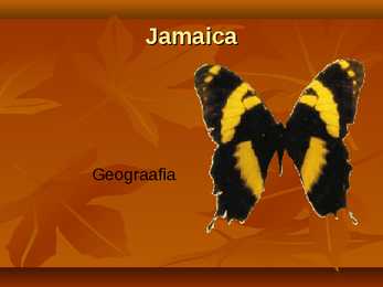
Jamaica Geograafia Jamaica Kati tsirk ja Janika Kübard Flag Coat of arms Location Jamaica is a country in the Caribbean Sea. Is the largest island of the Commonwealth Caribbean and the third largest of the Greater Antilles, after Cuba and Hispaniola. Jamaica lies in the hurricane belt of the Atlantic Ocean. Capital city The City of Kingston is the capital and largest city of Jamaica. Kingston is located on the southeastern coast of the island. Languages The official language of Jamaica is English. Informally Jamaican Patois is more commonly spoken by a majority of the
Its capital city is Melbourne and it was named after the British Prime Minister Lord Melbourne. Melbourne is said to be the heart of Australian finance and the headquarters of industry giants. Victoria is more an industry than a tourist state. Queensland is known for its natural riches like huge coalfields, copper, silver, lead. Its capital city is Brisbane, which is the third largest city in Australia. Because it lies in the Northeast part of Australia, its climate is mainly tropical. South Australia is famous as it is the region of fruit farming, vineyards and olive groves. Only the southern coast is fertile, most of the state is arid. Its capital is Adelaide, which is known for the Adelaide circuit. Western Australia is the biggest state in Australia. It is rich in deserts, as the central part of the state is practically a desert in whole and nearly uninhabited. On the other hand, the desert is important for its resources and mining
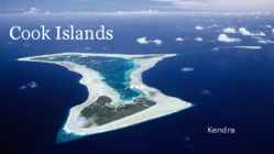
Cook Islands Kendra Location Capital: Avarua South Pacific Ocean 15 islands, 9 main islands Rarotonga Area: 240 square km Time zone: 12h behind Associated: New Zealand Geography Capital: Avarua Divided into two Coastline: 120km Natural resources: coconuts Climate: Tropical Mountainous, volcanoes, palms, soils, caves, People European, Chineese, African settlers Polynesian roots 2 polynesian languages: Pukapuka and other islands Official language Cook Islands Maori, English Population: 14,974 Villages, farms Politics Left: Henry Puna, right: John Key Self-governing state In international treaties Head of state: British monarch Parliamentary elections: 4 years Independence: 4th August 1965 Political parties: Cook islands party, the Democratic Economy
pressure fluctuations. If the oscillations are ‘in phase’ with already existing waves a furthermore in wave development occurs. If waves have reached a certain high, wind can attack them directly and causes an additional wave growth. Wave energy is a very dense form of indirect solar energy. To compare energy W densities: mean solar power density on earth (over a year) is about 250 . m2 kW Regarding waves this solar energy can be transferred up to 100 inside a wave mcrl per meter of crest length.
EurasiaSteppe, North America-Prairie, South AmericaPampa, South AfricaVeldt 3. Using the climate diagram describe the climate of the region. Temperate deciduous forest -Well-defined seasons with a distinct winter characterize this forest biome. Moderate climate and a growing season of 140-200 days during 4-6 frost-free months distinguish temperate forests. Temperature varies from -15° C to 25° C. Precipitation (750-1500 mm) is distributed evenly throughout the year. Temperate grassland- Semiarid, continental climates of the middle latitudes typically have between 25 cm and 50 cm of precipitation a year. Much of this falls as snow, serving as reservoir of moisture for the beginning of the growing season. Warm to hot summers are experienced, depending on latitude. In the winter, grassland temperatures can be as low as -40° C, and in the summer it can be as high 20° C. There are two real seasons: a growing season and a dormant season
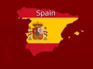
carnation, animal-ox, national bird-Short-toed Eagle ► The King : Juan Carlos I Symbols ► Anthem http://www.youtube.com/watch?v=0 S19dt7JWQs Geographical position ► In Southwestern Europe on the Iberian Peninsula ► Neighboring countries: France, Andorra and Portugal (in the west) ► Between Spain and Morocco is narrow Strait of Gibraltar ► Territory of the country includes the Balearic Islands in the Mediterranean, and 13 Canary Island (the largest of which is Tenerife and Gran Canaria) in the Atlantic Ocean Map Location in Europe Natural conditions ► Subtropical climatic zone (2 seasons) ► Summers are hot and dry in Spain, winters are rainy ► One of the driest countries in Europe (200-300mm per year / m²) ► Mineral resources : iron-, zinc-, copper-, lead- and uranium ore and mercury Population ► As at July 2007 - more than 40 million people (80% Hispanic, the rest
Territory and landscape Canada is one of the largest countries in the world. It covers nearly 4 million square miles. It is dividend into ten provinces( British Columbia, Manitoba, New Brunswick, Alberta, Nova Scotia, Ontario, Prince Edward Island, Quebec, Saskatchewan, Newfoundland ) along with two territories( the Yukon, the Northwest territories ). The capital city is Ottawa. Canada is a country rich in forests. It borders in the south with The United States and it's surrounded in the west by the Pacific Ocean, in the east by the Atlantic Ocean and above by many smaller bays, but is also borderedd with Alaska in the north-west. To the north of
coves, bays, intricate harbours, long sounds, and steep fiords. Its territorial waters stretch from the sub-tropical through to the sub-antarctic. Both islands tend to have better swimming beaches on their eastern coasts and the further north you go. The west coasts of both islands are quite rugged with cliffs and more unsettled weather. There are however some suitable swimming and bathing beaches here, with iron (volcanic) sand beaches (black sand) being common on the North Island. The longest beach in New Zealand is the 90 mile beach, which is actually about 60 miles long. This beach is famous for its huge sand dunes and resembles the Sahara Desert in places. This beach occupies the north western coastline of the North Island. New Zealand also has some great surf breaks in both islands. The most famous break is situated west of Hamilton in a small town called Raglan. Raglan is known for its unusually long surf rides and is a part of surfings world circuit. 1
.....................................................9 Vital waterways for people and wildlife..............................................................................................10 2 Introduction If you were asked to show on a world map the regions with the most biodiversity, your finger would probably end up pointing at the Amazon, the Congo Basin or the island of Borneo. But I chose New Guinea, an island that represents no more than 1% of the world's landmass, an array of extraordinary animals and plants have also flourished, such as tree kangaroos and birds of paradise. Close to 10% of the world's vertebrates are concentrated here, while 7% of the world's higher (vascular) plants grow on the island's productive soils. 3 Geography Papua New Guinea consists of over 600 islands and lies in the middle of the long
It is the third largest in the world after Russia and Canada. In the USA there are 50 states of which 48 lie together. The population of The USA is about 300 million people. The territory is about 10 million square kilometers. Its geography is very diverse ranging from moist rainforests to dry deserts and bald mountain peaks. There are two big mountain ranges, one of them is the Rocky Mountains and the other is The Appalachian Mountains. The Capital of The USA is Washington D.C. Other big and famous cities are New York, Los Angeles, Houston, Chicago and Las Vegas. The national anthem of the United States is "The Star-Spangled Banner", with lyrics written in 1814 by Francis Scott Key. There are 6 time zones. From east to west they are: Eastern Standard Time, which is 5 hours behind Greenwich Time, Central Standard Time, Mountain Standard Time, which is 7 hours behind Greenwich Time, Pacific Standard Time. Alaska and Hawaii have their own time zones: Alaska
Australia Australia is surrounded by the Indian and Pacific oceans, it is separated from Asia by the Arafura and Timor seas. Australia presents an enormous range of climatic conditions, since it covers thirty degrees of latitude. It is mostly temperate, but one third of the continent is tropical, and there are large desert areas. The two largest cities are Sydney and Melbourne. The capital of Australia is Canberra. It is a small city and was built in the early 1900s. History. Two hundred years ago there were no white people in Australia. The only inhabitants were dark-skinned people who were still living in a Stone Age. Their only weapons were stone knives and boomerangs. But their tribes had very well-worked- out customs
Weather in Sidney Sydney's climate is pleasantly temperate all year round with more than 340 sunny days a year. In summer (December to February), average maximum temperatures in Sydney are around 26°C. It can also be humid at this time with an average humidity of 65 per cent. Average maximum temperatures in the winter (June-August) are around 16°C. Sydney's rainfall is highest between March and June. Appealling climate - Australian seasons are the opposite to the Northern Hemisphere, summer starts in December, autumn in March, winter in June and spring in September. Australian seasons Spring: September November Summer: December February Autumn: March May Winter: June August The best seasons to travel to Australia (nicest weather) are in either Spring or Autumn