Homework I live in Muuga, it's about 13km from the city center. Muuga belongs to city Maardu, it is like a little village between Maardu and Pirita and Lasnamäe. Here in Muuga, there are many little cottages and detached houses with yards. It is a very quiet and calm village. We have here only 3 food-shops, two really small ones and a bigger one ,,Maxima". Here is also being built a kindergarden. Near here we have a little staying place, something like a motel. We have a bus from the center, it takes nearly 35 minutes to get from the center to Muuga. Bus comes every 17-25 minutes, so it is quite comfortable. A lot of place to walk, go jogging and ride a bike. I'm happy that i live near the bus stop, it's very good for me, but however sometimes I may miss the bus. I can walk here in my yard only in a robe and nobody will tell me anything, that's why i like Muuga and also for its tranquilness. But i d...
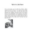
Tallinn's Old Town Tallinn is the largest and the capital city of Estonia. Tallinn occupies an area of 159 km2. It's situated on the northern coast of the country. Tallinn's Old Town has been listed among the top 10 digital cities in the world.It is not easy to determine the beginning of Tallinn history. The location probably attracted attention as a suitable port area. Many countries have ruled Estonia, for example Denmark, Sweden, Russia, Germany. Upper Town has always been the seat of whatever power that has ruled Estonia. The Lower Town has been demaged.
The United States of America (in North America) is a federal republic of 50 states. The total area of the United States is over 9.5 million square kilometres, making it the fourth largest country in the world in area. The capital city is Washington D.C. The major caracteristic of the United States is probably its great variety. Itranges from the Arctic to the subtropical, from the moist rain forest to the arid desert, from the rugged mountain peak to the flat prairie. Althought the total population of the United States is large by world standartst, over 302 million. The country embraces some of the world´s largest urban concentrations as well as some of the most extensive areas that are
the accumulation of humus. 6. How do the soils in tropical deciduous forest differ from the soils in tropical rainforest? The soil in tdf has more nutrients, because the leaves fall down and trees grow more sparsely. 7. Describe the layers of tropical rainforest. Emergents forest giants, the trees there are 50m or more. Canopy a dence layer, the trees there are 20-30m. There can be found many hardwoods, such as mahagony. Understory a dark and a humid area, contains saplings between the trunks of larger trees. 8. How does the vegetation in tropical deciduous forest differ from the vegetation in tropical rainforest? Trf has more kinds of trees than tdc. About 70% of the plants in trf are trees. 9. Using the picture (given in the test) describe how a plant is adapted to the life in tropical rainforest? Epiphytes, liana, climbers or stranglers. 10. What is an epiphyte
Põllumajandus- ja keskkonnainstituut A GIS-based analysis and prediction of land-use change in a coastal tourism destination area Artikli analüüs Tartu 2014 Sisukord Sissejuhatus ................................................................................................................................ 3 Artikli eesmärk ........................................................................................................................... 3 Andmed ja metoodika...........................................................................................
A 1. A border äärepeenar 2. A brand new plot- uhiuus ala 3. A coherent system sidev süsteem 4. A curved lawn kaarjas muru 5. A fencing screen puuaed, vahesein 6. A flower bed lillepeenar 7. A focal point keskpunkt 8. A fruit plot puuviljaaed 9. A garden shed katusealune aed 10. A gravel area kruusaga kaetud ala 11. A hedge hekk 12. A hidden area varjatud ala 13. A lawn muru 14. A natural boundary of trees and hedges 15. A path kõnnitee 16. A patio terass, siseõu 17. A screen-block wall kiviaed 18. A shady area varjus olev ala 19. A specimen shrub ilupõõsas 20. A sunny area päikeseline ala 21. A vegetable plot juurviljaaed 22. Abandoned mines- mahajäetud miinid 23. Absorb- neelab, imeb sisse 24. Abundant color- külluslik värv 25. Accented- õhuline
To: The Crime Prevention Officer From: - Date: 28 October 2010 Subject: Increase in crimes Introduction The purpose of this report is to suggest reasons why criminals target the area and give some advice on how to make buildings more crime-proof. 1 Inveiglement Firstly, people keep their valuable items in the visible places like on the window sill and that entices the criminals. Recommendation: Valuable items should be put away, where it is impossible to see them from the window. 2 Security systems Another thing to mention is that people do not give much attention to the security of their houses
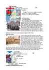
The Aran islands The Aran Islands comprise three islands (Inis Mór, Inis Meáin and Inis Óirr) located at the mouth of Galway Bay. The names are Irish language for 'the big island', 'the middle island', 'the south island`. The Aran Islands are rich in the language, culture and heritage of Ireland. The islands can be reached by sea by catching a ferry or by plane. The Burren The Burren, from the Gaelic word Boireann is an area of limestone rock covering imposing majestic mountains, and valleys with gently meandering streams. Monuments are older than Egypt's pyramids. Donegal mountains This view north from the Donegual moutintains is very popular for a photographers. Lakes of Killarney They consist of three lakes - Lough Leane, Muckross Lake (also called Middle Lake) and Upper Lake. The lakes lie in a mountain-ringed valley starting in the Black Valley.
St. James Park History St James’s Park is the oldest Royal Park in London. On James I's accession to the throne in 1603, he ordered that the park be drained and landscaped, and kept exotic animals in the park, includingcamels, crocodiles, and an elephant, as well as aviaries of exotic birds along the south. Charles II opened the park to the public, as well as using the area to entertain guests. On his desire had the park redesigned in a more formal style, probably by the French landscaper André Mollet. At the end of the 17th century and early 18th century were the cows in the park and could to buy fresh milk in "Lactarian". Location: The park is located in central London. This is 23 hectare large. St. James's Park is surrounded by Buckingham Palace to the west, The Mall and St. James's Palace to the North, Horse
LONDON London is the capital of England and the United Kingdom, the largest metropolitan area in the United Kingdom. London's population is about 7,518,000. Click to edit Master text styles Second level Third level Fourth level Fifth level Sightseeing Madame Tussaud Wax Figures museum Westminster Abby Big Ben
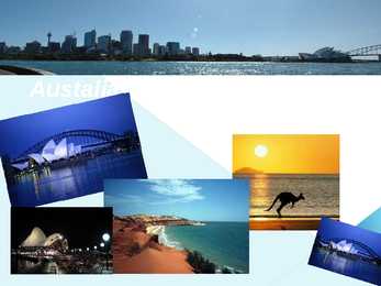
Austalia Sydney Opera House Harbour Bridge More
Located in the Ottawa Valley in the eastern portion of Southern Ontario, the city lies on the southern banks of the Ottawa River, a major waterway forming the local boundary between the Provinces of Ontario and Quebec. Connected by several bridges to its Quebec neighbour, the City of Gatineau on the northern shores of the Ottawa River, the two cities had a combined 2009 population of 1,220,674, making it the country's fourth largest metropolitan area. Although a recent StatsCan estimate in February 2010 surmises that the Ottawa metropolitan area has recently been surpassed by the Calgary metropolitan area as the Canada's fourth largest metropolitan area. There is no federal capital district in Canada. Although it does not constitute a separate administrative district, Ottawa is part of the federally designated National Capital Region (NCR), which encompasses Ottawa, Gatineau, and surroundings areas, having a population of over 1,451,000[6]
presentation talking about some places to visit in Tokyo and finally I will speak about few facts that you should know, when you decided to go to Tokyo. AS OU CAN SEE THERE ARE SOME GOOD REASONS TO VISIT TOKYO, THO IT COULD BE QUITE EXPENSIVE, ANYWAY THIS IS GREAT EXPERIENCE AND I THINK EVETYONE SHOULD GET IT. · Tokyo officially Tokyo Metropolis is one of the 47prefectures of Japan. Tokyo is the capital of Japan, the center of the Greater Tokyo Area, and the most populous metropolitan area in the world. It is the seat of the Japanese government and the Imperial Palace, and the home of the Japanese Imperial Family. Tokyo is in the Kant region on the southeastern side of the main island Honshu and includes the Izu Islands and Ogasawara Islands. Tokyo Metropolis was formed in 1943 from the merger of the former Tokyo Prefecture and the city of Tokyo.
the purpose of facilitating coordination and deconfliction of operations between adjacent units, formations or areas. Oma üksuse piirjoon Oma üksus (planeeritud) Vastase üksuse piirjoon Arvatav vastase üksuse piirjoon Üksuste vahelised piirjooned Control measures which define the left and right limits of a unit`s zone of action or sector. Together with the rear and forward boundary and a coordinating altitude, lateral boundaries define the area of operations for a commander. Taktikalised tingmärgid Kirjeldus Tingmärgid Oma üksuse eesliin (FLOT) Mehitatud eesliin Planeeritud eesliin Oma üksuse eesliini näide (FLOT) Vastase üksuse eesliin (FLET) Arvatav vastase üksuse eesliin Kokkupuutejoont A general trace delineating the location where two opposing forces are engaged. Taktikalised tingmärgid
between the Provinces of Ontario and Quebec. The 2006 Census recorded the population at 812,129, making it the fourth largest municipality in the country and second largest in Ontario. Connected by several bridges to its Quebec neighbour , the City of Gatineau on the northern shores of the Ottawa River, the two cities had a combined 2006 population of over 1,130,000, making it the country's fourth largest metropolitan area. On December 31, 1857, Queen Victoria was asked to choose a common capital for the Province of Canada (modern day Ontario and Quebec) and chose Ottawa. While Ottawa is now a major metropolis and Canada's fourth largest city, at the time it was a sometimes unruly logging town in the hinterland, far away from the colony's main cities, Quebec City and Montreal in Canada East, and Kingston and Toronto in Canada West.
The United Kingdom Mari-Liis Ojatamm Kärdla Ühisgümnaasium 10b The United Kingdom Scotland Wales England Northern Ireland Scotland Capital: Edinburgh Area 78,387 km2 Languages: English and Scottish Gaelic Population: 5,313,60 National symbols Thistle Tartam Flag Wales Capital: Cardiff Languages: English and Welsh Area: 20,779 km2 Population: 3,063,456 Flag Northern Ireland Capital: Belfast Languages: Irish and English Area: 13,843 km2 Population: 1,810,863
Hertfordshire. They comprise of chalk hills covered with beautiful beech woods, wild flowers, and a variety of wildlife. History · In pre-Roman times, the Chiltern ridge provided a relatively safe and easily negotiable route across southern Iron Age England, thus the Icknield Way (one of England's ancient trackways) follows the line of the hills. · The name "Chiltern" comes from the Cilternsæte, a tribe that occupied the area in the early Anglo-Saxon period. · One of the principal Roman settlements in the Roman province of Britannia Superior was sited at Verulamium (now St Albans) and there are significant Roman and Romano-British remains in the area. · Use · The hills have been exploited for their natural resources for millennia. The chalk has been quarried for the manufacture of cement, and flint for local building material. The
Sightseeing *Haanja Nature Park Haanja Nature Park (area about 17,000 ha) is situated on the Upland of Haanja and was established for the protection of the highest region of Estonia and the Baltic States In addition to the beautiful domed hills, deep valleys and picturesque small lakes old villages, customs and cultural traditions have been preserved * Timmas Nature Reserve Timmas Nature Reserve(the Reserve) is taken under the protection of natural forest and meadow colonies of protected species
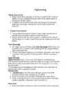
Maria-Julia Järv Euroopas ilma ennustamiseks kasutatavad piiratud ala mudelid HIRLAM (High Resolution Limited Area Model) HIRLAM on paljude Euroopa riikide ühine teadus-arendusprojekt, mille eesmärgiks on kõrglahutusliku ja -kvaliteetse ilmaennustustarkvara loomine, arendamine ja kasutamine osavõtjamaade ilmateenistuste kaudu nende riikide ja rahvaste hüvanguks. Eesti on HIRLAM Konsortsiumi täisliige aastast 2007. Eestis toimub HIRLAM arendustegevus Tartu Ülikooli Füüsika Instituudi atmosfäärilabori ja Keskkonnaagentuuri Prognoosmudelite osakonna koostöös.
Felipe de Neve. The current mayor is Antonio Villaraigosa. Population. By 1900, the population had grown to more than 102,000 people Now Los Angeles has a population of 12,9 million people. The history of Los Angeles. In the 1870s, Los Angeles was still little more than a village of 5,000. By 1900, there were over 100,000 occupants of the city. The first railroad, San Pedro Railroad, in what is today Los Angeles was inaugurated in October 1869 The Los Angeles coastal area was first settled by the Tongva and Chumash Native American tribes thousands of years ago Click to edit Master text styles Second level Third level Fourth level
There are ski resorts in the areas of Flagstaff, Alpine, and Tucson. In addition to the Grand Canyon National Park, there are several national forest, national parks, and nation monuments. About midway through February, the temperatures start to rise again, with warm days, and cool, breezy nights. The summer months of June through September bring a dry heat ranging from 90120 °F (3249 °C), with occasional high temperatures exceeding 125 °F having been observed in the desert area.November through February are the coldest months, with temperatures typically ranging from 40 to 75 °F (4 to 24 °C), with occasional frosts Etymology The name of the state appears to originate from an earlier Spanish name, Arizonac, derived from the O'odham name al onak, meaning "small spring", which initially applied only to an area near the Mexican silver mining camp of Planchas de Plata, Sonora. This is supported by the fact that the area
New York Latino English Pennsylvania Dutchified English Yeshivish Yinglish o Regional Northeastern dialects Boston English Hudson Valley English (Albany) Maine-New Hampshire English New York City Dialect, Northern New Jersey Dialect (New York metropolitan area) Providence-area English Vermont English Philadelphia-area English Buffalo English Inland Northern American English (includes western and central upstate New York) Wawarsing English Northeast Pennsylvania English (Scranton, Pennsylvania-area) Mid-Atlantic dialects
Canada Kaidi Laan K214 Inglise keel Canada ● population 35,344,962 ● area 9,984,670 km2 ● languages English and French ● capital Ottawa ● money dollar ● Canada is a country in North America consisting of ten provinces and three territories. ● Canada is the world's second-largest country by land area and the fourth-largest country by land area. ● Canada is a federal parliamentary democracy and a constituational monarchy. ● Canada is a memberof the Commonwealth of Nations. Thanks for watching
Introduction to RESIDENTIAL LAYOUT Today I will speak about... - Before planning residential area - Calculating the costs - Consumer preferences - Defining space and blocks arrangement Before planning residential area... You need to know about... - possible buyers in this area - how big amount of money the developer would like to spend on it Why need to know about possible buyers? because then you know about... - how big should be the houses / the type of house - should be there a garden / how big it should be - design of the house - public places How big amount of money the developer would like to spend on it It is important because... - you know about materials you can use in desing
Today I'm going to do a presentation about a book called ,,Forestry and the Forest Industry in Japan", edited by Yoshiya Iwai. --------------------- Participants in private forestry are classified into six categories: forestry households; companies; shrines and temples; joint holdings; various groups and cooperatives; and habitual joint holdings. Except for shrines and temples, these groups manage forests to produce income. In general, these forests are not very large: the average forest area per establishment was 3.7 ha in 1990. Groups operating forests of less than 100 ha control 67% of the total area. Hence forests are not necessarily owned by a few large concerns. Private ownership of forestland was officially permitted after the Meiji restoration of 1868, which marked the end of feudalism. Previously, forestland was legally owned collectively for the use of local communities. After the Meiji restoration, most of these ,,commons" became privately owned
6. Lord grant that Marshal Wade May by thy mighty aid Victory bring May he sedition hush And like a torrent rush Rebellious Scots to crush God save the King The Tower of London The Tower of London is London's oldest and most popular attraction, most famous for the Crown Jewels Buckingham Palace London Eye The London Bus The Grand Opera House The Giant's Causeway Belfast City Hall Area: Capital: London Total 130,395 km 2 England Population: Official language: 51,000,000 English National flower Red rose Scotland Capital: Edinburgh Population: Area: 5,144,000 78,772 km² Official language: English National flower Shamrock Ireland
Tartu Secondary School of Business New Zealand Report Kati-Liis Karu 10.A - I group TARTU 2009 Contents 1. Introduction ...................................................................................................3 2. Area. Population. Climate.........................................................................................4 3. Economy. Largest Cities........................................................................................5 4. Culture...........................................................................................................6 5. Conclusion .....................................................................................................7 6. References ......................
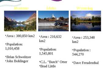
Montana Idaho Wyoming Ø Area : 380,850 km2 Ø Area : 216,632 Ø Area : 253,348 km2 km2 Ø Population: 1,010,458 Ø Population: Ø Population : 1,545,801 544,270 Ø Brian Schweitzer Ø John Bohlinger Ø C.L. "Butch" Otter Ø Dave Freudenthal Ø
• The stock of grey alder (Alnus incana) in Estonia in 2005 was 35 millions m³. A majority of Estonian grey alder stands grow in private forests where they make up 13.7% of all stands; in state forests their share is 1.7%. Grey alder (2) • The annual mean increment of Estonian grey alder stands is 7.1 m³ per hectare • The mean average volume is 182 m³ per hectare Grey alder (3) • The yield example of experimental area, located in Põlvamaa, Estonia 80 70 Dry ma ss t ha-1 60 50 40 30 20 10 0 2 3 4 5 6 7 8 9 10 12 Year Stem Branches Leaves Silver birch
Canada Joonas Põldre 9.c Capital and largest city Capital: Ottawa Area: 2,778.64 km2 (1,072.9 sq mi) Population: 812 100 (2006) Largest city: Toronto Area: 630 km2 (243.2 sq mi) Population: 2 503 300 (2006) Click icon to add picture Click icon Ottawa t o a d d p ic t ure Click icon to add picture Click icon t o a d d p ic t Toronto ure Government Federal parliamentary democracy and constitutional monarchy - Monarch Elizabeth II - Governor General David Johnston
ENGLAND Capital: London Flag: Area: 50351 sq (130410 km) Location: Symbol: The red rose is widely recognised as the national flower of England. The oak is the national tree of England. Interesting plases: Royal Opera House
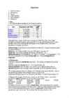
% (mid- Part Population (mid-2006) 2006) England 50,762,900 83.8 Scotland 5,116,900 8.4 Wales 2,965,900 4.9 Northern Ireland 1,741,600 2.9 United Kingdom 60,587,300 100 Although Britain is quite small in terms of land area (245,000 sq km), it has a large population of nearly 61 million, which ranks the 21st in the world (Britain is the 21st most populous state in the world) and the third largest in the European Union. The size of population is changing very slowly. Natural change is the difference between birth and death rates. It may be a natural increase or a natural decrease. Birth rate the number of babies born per 1,000 persons per year 12
Lake Võrtsjärv Scientific editors Juta Haberman Ervin Pihu Anto Raukas Liis Sommer The outline Rural municipalities River geology Shores Flows Temperature Planktonic algae Fishes Animals Lake Võrtsjärv is a lake in southern Estonia with an area of 270 km² . It is the second largest lake of Estonia. The shallow lake is 33.7 m above sea level. The river Emajõgi flows from Lake Võrtsjärv to Lake Peipsi. Lake Võrtsjärv area comprises seven rural municipalities bordering the water, connected with each other by traditions of joint activities, set throughout history. The
London is the capital of both England and the United Kingdom, and the largest metropolitan area in the European Union. An important settlement for two millennia, London's history goes back to its founding by the Romans. Since its foundation, London has been part of many movements and phenomena throughout history, including the English Renaissance, the Industrial Revolution, and the Gothic Revival. The city's core, the ancient City of London, still retains its limited medieval boundaries; but since at least the 19th century,
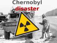
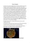
used helicopters to pour sand and boron on the reactor debris. The sand was to stop the fire and additional releases of radioactive material; the boron was to prevent additional nuclear reactions. A few weeks after the accident, the crews completely covered the damaged unit in a temporary concrete structure, called the “sarcophagus,” to limit further release of radioactive material. • After the accident, officials closed off the area within 30 kilometers (18 miles) of the plant, except for persons with official business at the plant and those people evaluating and dealing with the consequences of the accident and operating the undamaged reactors. The Soviet (and later on, Russian) government evacuated about 115,000 people from the most heavily contaminated areas in 1986, and another 220,000 people in subsequent years. The Exclusion Zone • An area originally extending 30
London is the capital of both England and the United Kingdom, and the largest metropolitan area in the European Union. An important settlement for two millennia, London's history goes back to its founding by the Romans. Since its foundation, London has been part of many movements and phenomena throughout history, including the English Renaissance, the Industrial Revolution, and the Gothic Revival.The city's core, the ancient City of London, still retains its limited medieval boundaries; but since at least the 19th century, the name "London" has also referred to the whole
In many of them it's spoken as an official language. But it's also spoken as the dominant (domineeriv, valdav) language. Nowadays you can go almost everywhere and you can make through everything when you know some English. But still, no matter in which country you go, they're still very different. For example Australia, United Kindgom and its parts Endland and Scotland. Australia is located in the Pacific ocean and it's sixth country in the world for it's size. It's total area is 7741220 km². This country doesn't have an official language, but it's national language is English. Australia has much lakes and rivers in it. More exactly about 68 920 km² is made up by lakes and rivers. Climate in australia is dampish and warm. Australia's capital is Canberra, but the largest city is Sidney. The symbol of Australia is kangaroo, it's the biggest marsupial (kukkruloom) in the world. Also it has
SUURBRITANIA,ROOTSI,POOLA,SLOVAKKIA. 1) Võrdle metsaressursse 4s riigis.Milline neist riikidest on metsarikkaim? metsavaeseim? Milliste näitajate põhjal otsustasite? Kõige rikkaim neis riikidest on ROOTSI , sest Rootsis on ligikaudu 27,5 (1000 ha) metsa. Area (1000 hectares) FRA 2005 categories 1990 2000 2005 Forest 27,367 27,474 27,528 Võrdluseks: SLOVAKKIAKS: Area (1000 hectares) RA 2005 categories 1990 2000 2005
UTAH ARIZONA NEW MEXICO UTAH Population: 2,78 million Area: 219,890 sq km Capital: Salt Lake City Highest point: Kings Peak(4,126 m) Lowest point: Beaver Dam Wash (664 m) PLANTS AND ANIMALS OF UTAH Indian rice grass Honey bee Blue spruce California Spanish Sego seagull sweet lily Rocky mountain elk onion Bonneville cutthrout trout CITIES OF UTAH
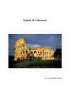
achievements in earthquake engineering. It is one of Rome's most popular tourist attractions and still has close connections with the Roman Catholic Church, as each Good Friday the Pope leads a torchlit "Way of the Cross" procession to the amphitheatre.[5]The Colosseum is also depicted on the Italian version of the five-cent euro coin. History Construction of the Colosseum began under the rule of the Emperor Vespasian in around 70 72AD. The site chosen was a flat area on the floor of a low valley between the Caelian, Esquiline and Palatine Hills, through which a canalised stream ran. By the 2nd century BC the area was densely inhabited. It was devastated by the Great Fire of Rome in AD 64, following which Nero seized much of the area to add to his personal domain. He built the grandiose Domus Aurea on the site, in front of which he created an artificial lake surrounded by pavilions, gardens and porticoes
Table of Contents 1.Alaska info...................................3.lk 2.Geography.....................................4.lk 3.Natural features......................5.lk 4.Climate...........................................6.lk 5.Pictures.........................................7.lk 6.Used Sources..............................8.lk Alaska info Alaska is the largest state in the United States by area. It is situated in the northwest extremity of the North American continent, with Canada to the east, the Arctic Ocean to the north, and the Pacific Ocean to the west and south, with Russia further west across the Bering Strait. Alaska is the least densely populated state of the U.S. 2 Alaska was purchased from Russia on March 30, 1867, for $7.2 million at approximately two cents per acre. The land went through several administrative changes before becoming
school should be represented in the brochure and which photographs should be used. Short History of the School In the brochure, there should be a section for the school history to show people how long this school has been working and how successful it has been over the years. Secondly, why there should be a part fot history is for people to understand the school's motto and ethics better. Other Schools in the Area In my opinion, other schools in the area should also be noted because it shows the good location of this school. Having other good and wealthy schools in the area, gives us the possibility to show us from the same side. School Activities In addition to these, we should mention the different activities that we have in our school. We should mention activities such as Playbox- a very successful dancing competition that we organize every year, Photocontest- a contest where it is possible for students use their
keelatud. Teooria 1 Vandenõuteoreetikute sõnul hoitakse ja uuritakse alla kukkunud UFO laevu Ala 51-s. Nendelt leitud tulnukad elavad seal ja aitavad USA teadlastel ehitada ajamasinat. Ka tänapäevased reaktiivlennukid olevat leiutatud UFO laeva eeskujul Ala 51-s. Teooriaid tõestatakse videotega, kus on näha lennumasinaid tegemas manöövreid, mida praegu teadeolev tehnika ei võimalda. Osa infost Area 51 kohta pärineb Robert Scott Lazarilt, kes väidab end olevat töötanud Area 51 naabruses salajasel objektil S4, kus ta uuris tulnukate lennuaparaati, mis kasutas kütusena elementi 115. Kriitikute sõnul ei ole Lazar füüsika vallas pädev ega oma ka tegelikult teaduskraade, mida ta väidab endal olevat. Teooria 2 Teiseks arvatakse, et inimene pole oma jalga Kuu peale tõstnud mitte kunagi. Teoreetikute sõnul on Ala 51-s Kuu keskkonnaga sarnanev
· Spotlight - (a circle of strong light which is sent from) a lamp whose beam can be directed Inside the theatre: · Box office · Dressing room · Foyer · Cloakroom · Stage · Scenery the painted backcloths, stage structures, etc, used to represent a location in a theatre; · Curtain · Podium a small platform for the conductor of an orchestra; · Baton a wand used by a conductor; · Wings (in a theatre) the area just to each side of the stage where actors wait to come on it; · Seats · An aisle a long passage between rows of seats; · Rows lines of seats in a theatre or cinema; · the orchestra pit the area that is occupied by the orchestra, located in front of the stage; · the stalls, orchestra seats - the seats on the main level of a theatre; · the dress circle/mezzanine the lowest balcony in a theatre;
journalist Johann Voldemar Jannsen. I actually have quite many supermarkets around me but I chose this one because I feel like it has more of a story than the others. When you get to the building and have a look at it, you would definitely think that it needs renovation and it is definitely quite old and is from the Soviet times. It is actually really colourful, compared to most supermarkets, therefore it attracts all kinds of children from the area. It has a huge variety of materials in the shop, starting from fruit and vegetables and ending with toys, clothes and even cooking meals. Sadly, the fact that it is old, makes it quite enjoyable for the alcoholics to be around the area. It has three checkout counters where you can buy your groceries. The best thing ever about the area and the people is that most of them are actually really talkative and every time I go there, I always meet someone new
New Zealand vs Estonia Places to visit Argo Pihtjõe VLE-3 Some facts: Full name: Republic of Estonia Full name: New Zealand Population: 1.3 million (UN, 2010) Population: 4.3 million (UN, 2010) Capital: Tallinn Capital: Wellington Area: 45,227 sq km (17,462 sq miles) Area: 270,534 sq km (104,454 sq miles) Major languages: Estonian Major languages: English, Maori Major religion: Christianity Major religion: Christianity Life expectancy: 69 years (men), 79 Life expectancy: 79 years (men), 83 years (women) (UN) years (women) (UN) Monetary unit: euro Monetary unit: 1 New Zealand dollar Main exports: Machinery, textiles, wood ($NZ) = 100 cents products
Accessible- easy for anyone to obtain and use Admittedly- used for saying that you admit something is true, especially when this makes your main idea weaker Affordable- cheap enough for ordinary people to afford Agricultural- relating to farming Alcoves- a small area in a room that is created by building part of one wall further back than the rest of the wall Ample- enough, and often more than you need Attic- the room in a house under the roof Bedsit- a room that you rent that is used for both living and sleeping in Brick pillars- Bungalow- a house that is all on one level Caravan- BRITISH a vehicle that people can live and travel in on holiday. Caravans are usually towed (=pulled) by a car. The American word is trailer
Gran Canaria Gran Canaria is the second most populous island of the Canary Islands after Tenerife, and the third largest in area after Tenerife and Fuerteventura. Gran Canaria is located southeast of Tenerife and west of Fuerteventura. The island is of volcanic origin, mostly made of fissure vents. Gran Canaria is the second most populous island of the Canary Islands after Tenerife. Gran Canaria's surface area is 1,560 km² and its maximum altitude is 1,949 meters (Pico de Las Nieves). It has a round shape, with a diameter of approximately 50 km. About 80% of the volume of the island was formed during the Miocene period, between 14 and 9 million years ago. This is called the "Old Cycle" and is estimated to have lasted some 200,000 years and have emitted about 1000 km3, mostly of fissural alkali basalt. This cycle continued with the emission oftrachytes, phonolites and peralkaline rocks
Floods and Tsunamis Flood is a natural event or occurrence where a piece of land that is usually dry land, suddenly gets submerged under water. Some floods can occur suddenly and recede quickly. Others take days or even months to build and discharge. When floods happen in an area that people live, the water carries along objects like houses, bridges, cars, furniture and even people. It can wipe away farms, trees and many more heavy items. Floods occur at irregular intervals and vary in size, duration and the affected area. It is important to note that water naturally flows from high areas to low lying areas. This means low-lying areas may flood quickly before it begins to get to higher ground. Flooding is extremely dangerous and has the potential to wipe away an
2. 2D IMAGING METHODS BASED ON THRESHOLDING The main idea of almost all the papers dealing with 2D imaging methods is to perform pills detection using image segmentation [1] i.e. the process of partitioning the original image into multiple segments including fabric background and pills. This process is usually, in its turn, aimed at determining parameters such as the number and the density of pills and/or the area occupied by the pills on the fabric surface. Once this task is performed, pilling grade is obtained as a parameter inferred from the number of pills, or by comparing the pilled fabric with a reference fabric (either with or without pills). As a matter of fact, almost all methods classified in this category use, at some point, an image binarization by applying one or more thresholds and, possibly, morphological operations on images