Leidsid 33 sarnast õppematerjali, mis on seotud failiga "Zion National Park". Need materjalid aitavad sul teemat sügavamalt mõista.
utah, desert, species, activities, riding, tours, river, located, southwestern, states, near, founded, unique, different, zones, woodland, forest, first, dates, years, oldest, there, birds, mountains, mammals, falcon, rivers, slot, california, jeep, paintball, cattle, drives, ranch, spas, entertainment, running, golf, climbing, guided, shopping, hikingArizona Arizona is a state in the southwestern region of the United States. It is also part of the Western United States and of the Mountain West states. It is the sixth largest and the 14th most populous of the 50 states. Its capital and largest city is Phoenix. Arizona is one of the Four Corners states. It borders with New Mexiko, Utah, Nevada, California, and Mexico, and one point in common with the southwestern corner of Colorado. Climate Southern Arizona is known for its desert climate, with very hot summers and mild winters. Northern Arizonafeatures forests of pine, Douglas fir, and spruce trees; the Colorado Plateau; some mountain ranges (such as the San Francisco Mountains); as well as large, deep canyons, with much more moderate summer temperatures and significant winter snowfalls. There are ski resorts in the areas of Flagstaff, Alpine, and Tucson. In addition to
the sixth largest nation, its territory is 7,686,850 sq km and its population reaches today over 20,5 million people. It is the only nation to govern an entire continent and its outlying islands. Australia's capital is Canberra, the only city with its own territory. It was built in the early 1900s just to be the capital. The official language is English and the official name of Australia is the Commonwealth of Australia. Australia is located on the Southern Hemisphere (because of that Australia is also called "A land down under"). 2 . Geographical position Australia is an island continent and it is located between the Indian and South Pacific oceans south east of Asia. From the north it is bordered by the Timor Sea and the Torres Strait. From the east by the Coral Sea and the Tasman Sea. Australia's coastline is about 37,000 km long. The Great Australian Bight washes the southern coast
the Solomon Islands, Vanuatu in the northeast, and New Zealand in the southeast. Its capital is Canberra. Other big cities are Melbourne, Sydney, and Brisbane. National language in Australia is English. Monetary unit is Australian dollar. Their national holiday is on the 26th of January. In 1788 on the 26th of January the first fleet arrived at Botany Bay and established a penal colony near modern-day Sydney. Geographical Position Australia is located in the Southern Hemisphere. It’s the only continent except for Antarctica that is all south of equator. Sometimes Australia is called the island continent. There is a great reason why. It really is an island. It is 2880 km from the mainland of Asia and is almost half way round the world from Europe. More than 9 600 km separates it from America. Australia lies between the Pacific and Indian oceans. The Timor Sea and the Arafura Sea separate Australia from Indonesia. In the north the
Topic Australia Introduction Many people know Australia as the land down under because it is the only continent except for Antarctica that is all on the southern hemisphere. Its name means ,,Southland". The official name of the country is the Commonwealth of Australia. It's capital is Canberra. Australia is the sixth largest country in the world but the smallest continent. Australia has 6 states and 2 territories (New South Wales, Victoria, Tasmania, Queensland, Western Australia , South Australia, The Australian Capital Territory and the Northern Territory). The Australian people are culturally the same as the Anglo Americans. There also live aborigines. Aborigines are the ancestors of the people. Like the US and Canada, Australia was an English speaking colony of Great Britain. Today Australia is a modern developed country with a diversified economy. Australia is an island
"It is south of the equator. Sometimes it is also called the island continent because it is an island. There are about twenty million people in Australia.It is 1,800 miles from the mainland of Asia and almost half way round the world from Europe. More than 600 miles of ocean separate it from Americas. Since Australia is south of the equator, its seasons are just the opposite of ours. It has summer while we have winter, and the other way round. States and Territories. Australia consists of six states, two territories and eight external territories. The six states are: Western Australia (capital Perth), South Australia (capital Adelaide), Queenslnd (capital Brisbane), New South Wales (capital Sydney), Victoria (capital Melbourne) and Tasmania (capital Hobert). The two territories are the Northern territory (capital Darwin) and the Capital territory (capital Canberra). Politics The head of the state is the queen of the United Kingdom. She is represented by governor general
Tallinn English College Topic The United States of America Form Tallinn 2005 Introduction The United States of America is a very big country. Its territory is about 9.4 million square kilometres and its population is more than 260 million people, 12% of them are the Afro-Americans. It is the world's third-largest country by size and by population. The population density is about 27 people per square kilometre. Most of the people live in towns. There are 50 states in America. The biggest of the state is Texas, next by size are California, Alaska and Montana. Six states - Maine, Vermont, New Hampshire,
Australia Fact file: Australia comprises a land area of 7 686 850 square kilometres. Its population is about 21,3 million people. Australia's capital is Canberra. The national language is English. The official name of it is the Commonwealth of Australia. It's divided into six states and two territories: New South Wales, Queensland, South Australia, Western Australia, Tasmania, Victoria, Australian Capital Territory (ACT) and Northern Territory. Symbols: Australia had the British flag as their official flag until 1901, when the Commonwealth of Australia was formed. Over 30 000 entries attracted the official competition. Five of them, which contained almost identical designs, were placed equally first
Commonwealth of Australia. Australia is the smallest continent, but one of the largest countries in the world. Its area is about 7,6 million sq kilometers. Its population is about 20,0 million and most of the people live in bigger cities: Sydney (4.2 million), Melbourne (3.7 million), Brisbane (2 million) and in Canberra, Which is also the capital of Australia. National language in Australia is english and the monetary unit is Australian dollar. Australia is divided into 6 states and 2 territories. Symbols Australia has a British Union flag. It is red, white and blue. Five small stars represent the constellation Southern cross. The big star represents country's states and territories. In 1901 the flag was chosen from about 30000 entries in a public contest. It was officially adopted as Australian flag in 1953. The coat of arms features a kangaroo and an emu (the national
Australia Australia is the smallest continent in the world. It is 7.6 million square kilometres big. It is often called the island continent because it is rather small for a continent and very big for an island. There are only five countries bigger than Australia in the World. There are five states in the mainland. Tasmania is also considered as a state so there are six states. The Northern Territory and Canberra are also independent but they are not states. Canberra is the capital of Australia and it is situated between Sydney and Melbourne because both of these cities wanted to be the capital. The population is about 19 million people and growing. New South Wales is the most populated state and Victoria is the most densely populated state. The national language is English. It is English because British settlers came to live in Australia in
Rocky Mountains along the southwest border, while its lowest point is 152 metres on the Slave River in Wood Buffalo National Park in the northeast. Alberta contains numerous rivers and lakes used for swimming, water skiing, fishing and a full range of other water sports. There are three large lakes and a multitude of smaller lakes less than 260 square kilometres each. Lesser Slave Lake (1,168 square kilometres) is northwest of Edmonton. The longest river in Alberta is the Athabasca River which travels 1,538 kilometres from the Columbia Icefield in the Rocky Mountains to Lake Athabasca. Edmonton is the most northerly major city in Canada, and serves as a gateway and hub for resource development in northern Canada. Alberta's other major city, Calgary is surrounded by extensive ranching country. Almost 75% of the province's population lives in the Calgary- Edmonton Corridor, in and between the two major cities.
estimated 200 000 or more adults had been removed. The island of Floreana was populated with a group of convicts' in October 1832. Charls Darwin visited the island in 1835, he spent there 5 weeks. Nowadays five of the islands are populated with about 40 000 inhabitants. The name Island of Galapagos means island of tortoises. Every animal or plant had to cross about 1000 km of open ocean to arrive on Galapagos. Despite the trials of arrival, over 560 species of native plants, over 55 species of native land vertebrates and 1700 species of native insect are found on Galapagos. There are no large mammals, the key herbivores are reptiles, and the top predators are birds and snakes. Mammals on the Galapagos include two species of bat, two endemic rice rat species and its most famous mammals - the Galapagos sea lion and fur seal. There can be identified four broad categories of habitat (the coastal zone,
In 1867 the Confederation of Canada was set up. In 1931 Canada became independent from Britain. Canada has a very high standard of living. It is also ranked number one on the UN ´Human Development Index´. The country is particularly advanced in areas of health, education, social protection and human rights. There are also many things that make Canada attractive for tourists. Many visitors to the country come for activity holidays. Outdoor sports like skiing, hiking, riding, swimming, boating, rafting, tennis, golf and fishing are encouraged across Canada. A half- or full-day fishing trip with a guide, which end up with cooking a meal from the catch, has recently become popular. In one word Canada is a vast country with many diversities and tourist attractions. With its spectacular nature Canada is wonderful. Location. Canada is a huge country in the continent of North America. It is bordered with the
Indeed, all the Canadians except the Indians and Eskimos, are really immigrants or their descendants. Canada is politically a young country. In 1967 the people celebrated its first century of independence. It was on the first of July, 1967, that four provinces of British North America joined together and formed the Dominion of Canada. Geographical facts. Canada occupies the northern portion of North America. It shares land borders with the United States to the south and with Alaska to the northwest. It shares territorial water boundaries with the United States, Greenland to the northeast, and Saint-Pierre and Miquelon (an overseas community of France) to the southeast. Canada stretches from the Atlantic Ocean in the east to the Pacific Ocean in the west. To the north lies the Arctic Ocean. The most densely populated part of the country is the Quebec City-Windsor Corridor in the east
Newfoundland in the east and those of the Arctic Archipelago in the north. In longitude Canada extends from approximately 52° to 141° W, a distance that spans six time zones. In latitude it extends from approximately 42° to 83° N. With its vast Arctic and subarctic territories, Canada is often considered a country only of the far north; however, the peninsula of southern Ontario juts deeply south into the heartland of the United States, and its southernmost point, Middle Island in Lake Erie, is at the same latitude as northern California. The country also includes several major islands, including Baffin, Ellesmere, Victoria, Newfoundland, and Melville, and many small ones. Its border with the U.S., the longest border in the world not patrolled by military forces, extends 8,890 km. 3. Mountains, lowlands Canada's vast area means it has many varying types of terrain, much of which is mountainous
The Estonian language words were written by J. V. Jannsen. It was officially adopted after the War of Independence in 1920.The same melody with different words is also Finland's national anthem. The current coat of arms of Estonia is a golden shield which includes three slim, blue leopards (or lions) in the middle, with oak branches along the side of the shield. It originates from Denmark. It was officially adopted in 1925. Geography Estonia is the northernmost of the three Baltic States. It is located on the northern hemisphere on the eastern shores of the Baltic Sea in the north-east of Europe. It has land contact with Russia from the east and Latvia from the south. In the north The Gulf of Finland separates Estonia from Finland. The Gulf of Riga is situated to the south-west. Estonia has more than 1500 islands. The biggest ones are located to the west. The four biggest islands are Saaremaa, Hiiumaa, Vormsi and Muhu.
Tallinna Inglise Kolledz Topic United States of America Mari-Liis Pakats Tallinn 2007 2 Introduction..................................................................................................................4 Geographical Position..................................................................................................4 Geographical Regions..................................................................................................5 Climate ......................................
It lies off the north-eastern coast and extends for over 2000 kilometres. The famous mountain range in the eastern part of Australia is the Great Diving Range and it's highest peak is Mount Kasciusco's 2230m. In the continental part, there are the Macdonnell ranges. Other smaller mountain ranges are the Musgrave Mountains, the Hammessley Mountains and the Darling Mountains. The continental part of Australia is mostly covered with deserts and these deserts are the Great Sandy Desert in the north-western part, the Great Victoria dessert in the southern part and Gibson desert and the Simpson desert. The Murray River is the largest river of the country and it is 2,375 kilometres long, it rises in the Australian Alps and flows to the south-west. The waters of Murray flow through several lakes, such as Lake Alexandrina and The Coorong. Other Lakes are L.Eyre and L.Mackay. Climate
Tallinn English College Topic The United States of America Tallinn 2007 1. Introduction The United States of America's territory is over 3.7 million square miles (over 9.6 million km²) and population more than 300 million people. The capital city is Washington D.C. Although the United States has no official language at the federal level, English is the de facto national language. English is the most common language for daily interaction among both native and non-native speakers. Spanish is the second language. The largest city is the New York City. The Government is Federal constitutional republic and the president is George W. Bush. 2. Geographical position The United States of America is located on the continent of North America. It has borders with
Tallinn English College English Anita Kuprijanovits Form 8b THE UNITED STATES OF AMERICA Report Supervisor: Mare Kallas Tallinn 2009 Introduction Name: The United States of America Area: ~10 mln km2 Population: ~300 mln people Symbols: The American Flag- consists of 13 equal horizontal stripes of red alternating with white and represent the Thirteen Colonies. The 50 small, white stars represent the 50 U.S. states. The U.S. flag is commonly called ,,the Stars and Stripes". The Statue of Liberty, that is locatd in New York,is a gift from the France. The Libety Bell, that is a bronze bell that symbolizes freedom in the United States of America. It
The highest mountain in Australia is Mount Kosciuszko, at 2,228 metres. Australia's longest river, the Murray-Darling, is 2,700 kilometres long. The only large permanent lakes in Australia have been artificially created, as most of the natural lakes there are dry for months or years at a time. Lake Eyre is the largest lake in Australia and also the lowest point. One of the most beautiful things you can see in Australia is Uluru, also called Ayers Rock. It is an enormous rock in the middle of the desert in the Northern Territory. It is three kilometres long and nearly 2.5 kilometres high in total. It is 600 million years old, and it is the largest rock of its kind in the world. Uluru is a sacred place for the Aborigines. Thanks to Australia's isolation, it has plants and animals unlike anywhere else in the world. The kangaroo is the most well-known of them. They have strong back legs and tails, allowing them to travel at high speeds and jump very high and far
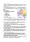
The mainland covers an area of 7.7 million km² and it is about 3700 km from the most northern point to its most southern point and about 4000 km from east to west. There are also many different seas around Australia, like the Coral and the Tasman Seas in the west or the Timor and the Arafura Seas in the north, where the Indian and the Pacific Oceans meet. Because all seas and oceans near Australia are warm, surfing is a very popular hobby. Political subdivision Australia is divided into six states, which are: · New South Wales · Victoria · Queensland · South Australia · Western Australia · Tasmania New South Wales is the most populous state in Australia. Its capital is Sydney. Victoria is one of the most densely populated states in Australia. Its capital city is Melbourne and it was named after the British Prime Minister Lord Melbourne. Melbourne is said to be the heart of Australian finance and the headquarters of industry giants. Victoria is more an
which Stewart Island is the largest. North and South Islands are separated by the 32km wide Cook Strait. The total land area is 270,535 sq Km, about the size of Italy, the United Kingdom or the US state of Colorado. North Island is volcanically active with three active volcanoes. South Island has the high snow covered mountain peaks and glaciers of the Southern Alps, a range running almost 500Km along the Island. The longest river is the Waikato on North Island (425 Km), the largest inland stretch of water is Lake Taupo also on North Island (607 sq Km) and the highest point is Mount Cook on South Island (3754 m). Over 75% of New Zealand is above 200m. Land use is broken down to about: forested 30% - meadows and pastures 50% - agricultural and under permanent cultivation 15% . Sheep and cattle graze on the rich farmland around Hamilton and New Plymouth in North Island and around Dunedin and Invercargill on South Island.
London History The Romans AD 43- AD 410 The Romans finally invaded Britain in AD 43 from Kent. The Romans lead by Julius Caesar attempted to invade Britain twice before that in 55 and 54 BC but the invasions were unsuccessful. They made their way to the river Thames and sailed up it. The Romans knew it was important to control a crossing point at the river Thames, so they decided to build a settlement on the north bank. Although small settlements had been built on the banks of the Thames, the Romans were the ones who built the first city. They called their city Londinium. The Roman engineers noticed that the point where the swampy river narrowed would make an ideal crossing point, they built London Bridge. Less than 20 years later the native Iceni tribe, led by Queen Boudicca, rose up against the Romans in revenge for mistreatment and burnt
I. Portugal ABOUT Photo Location of Portugal (dark green) Portugal (Portuguese: Portugal, IPA: [putua]; officially the Portuguese Republic, Portuguese: República Portuguesa) is a country located in Southwestern Europe, on the Iberian Peninsula. It is the westernmost country of mainland Europe, and is bordered by the Atlantic Ocean to the west and south and by Spain to the north and east. The Atlantic archipelagos of the Azores and Madeira are Portuguese territory as well
Australia is the world's smallest, flattest and driest continent. It is also the oldest some of the rocks are more than 3,000 million years old. It is the 6th largest country. Its territory is 7 700 000 km2. Australia is an island continent, washed by the South Pacific Ocean, The Australia Sea, the Timor Sea, the Indian Ocean, the Southern Ocean and the Tasman Sea. As a result, its seasons are the opposite of ours. Australia consists of six states, two major mainland territories, and other minor territories. The states are New South Wales, Queensland, South Australia, Tasmania, Victoria and Western Australia. The two major mainland territories are the Northern Territory and the Australian Capital Territory. English is the offical language, and is spoken and written in a distinct variety known as Australian English. It is the only language in the home for around 80% of the population
Traveling is the movement of people or objects (conveyances) between relatively distant geographical locations. Travel may occur by human-powered transport such as walking or bycycling, or with vehicles, such as public transport, automobiles, trains and airplanes. Etymology The term "travel" originates from the Old French word travail. The term also covers all the activites performed during a travel (movement). A person who travels is spelled "traveler" in the United states, and "traveller" in the United Kingdom. Purpose and motivation Reason for traveling include recreation, tourism or vacationing, research travel for gathering information, for holiday to visit people, volunteer travel for charity, migration to begin life somewhere else, religious pilgrimages and mission trips, business travel, trade, commuting, and other reason, such as to obtain health care or fleeing war or for the enjoyment of traveling.
2006 1. Introduction If you had to use two words to describe Canada, they might be large and diverse. Canada is the second largest country in the world with a territory of about 10 million square kilometers and it is bordered by three oceans: the Arctic, the Pacific and the Atlantic Oceans. The population of Canada is about 31 million people. About 77% of the people live in cities which lie in a band about 100 miles wide above the border of the United States. The capital of Canada is Ottawa. Other large cities are Montreal, Toronto, Vancouver, Winnipeg and Quebec. 2. Geographical position Canada is a huge country in the continent of North America. It is bordered with the Atlantic Ocean in the east, the Pacific Ocean in the west, the United States of America in the south and the Arctic Ocean in the north. Canada is a vast country, with a territory of 3.8 million
Argentina has made claims to the Falkland Islands and Spain to Gibraltar. History When the glaciers retreated from Britain about 10,000 years ago, Stone-Age men started to inhabit the isles. The early Britons came across the land bridge which joined Britain to the continent. They were cave-dwellers at first. This way of life was replaced by the invaders from the Mediterranean lands. These men were the first farmers. In about 500 BC came the people whose homeland was near the Rhine River. These were the Celts. The Roman invasion began in 43AD. The Romans were highly organized conquerors. They built good roads, baths and bridges. The Romans stayed in the British Isles up to the 5th century. The remarkable thing about the Romans is that, despite their long occupation of Britain, they left very little behind. Most of the villas and temples the impressive network of roads and the cities they founded, including Londinium,
The national flower is cornflower, national bird is barn swallow and national stone is limestone. It is a land of great natural beauty with a long and varied history and rich culture. It has served as a junction of international trade routes for centuries. History. The oldest marks of habitation on the territory of Estonia date from the 8th millennium BC. Fortified settlements were established in the 1 st century BC. The ancestors of Estonians formed several independent states headed by elected elders. Until the beginning of the 13th century Estonia was politically independent. Then began a long chain of occupation and control by foreign powers. In the 1200s the German crusaders converted Estonia into a Christianity by force and took control over South Estonia. In 1219 Denmark conquered Northern Estonia. About a century later, in 1346 Denmark sold its territory to Germany. By the 1500s German nobles owned much of Estonia's land
Alice Tärk, 9b Tallinn 2007 FACTFILE Area: 45 228 sq km Poplulation: under 1.4 million Capital: Tallinn Language: Estonian Currency: Eesti kroon (EEK) Main religion: Lutheran National holiday: 24 February (anniversary of the republic) National flower: Cornflower National bird: Barn Swallow National stone: Limestone LOCATION The Republic of Estonia is the northernmost and smallest of the three Baltic States. It is located on the eastern shores of the Baltic Sea in the north east of Europe. To the east the country borders Russia. Latvia is the countries neighbour to the south. From the west the coast of Estonia is washed by the Baltic Sea and from the north by the Gulf of Finland. The length of the coastline is approximately 3 800 km. The longest distance from east to west is 350 km, while north to south Estonia stretches 240 km. THE NAME
Palace, and a valuable collection of the 16th 20th c. art from Western Europe, Russia and China, donated to the museum by Johannes Mikkel, at Mikkel Museum at Kadriorg Art Museum; · Art of Adamson-Eric (19021968), one of the most outstanding Estonian painters of the 20th century, at Adamson-Eric Museum; · national romanticism of an Estonian artist of the first generation, Kristjan Raud (1865 1943), at Kristjan Raud House Museum located in Nõmme, in the premises of the final home of the artist. Kadriorg Art Museum The Kadriorg palace and park were founded by the Russian czar Peter I. According to the designs of the architect Niccolo Michetti, invited from Rome, the palace was built after the Italian villas, consisting of a main building and of two annexes. The well-preserved great hall is one of the best examples of Baroque architecture not only in Estonia but also in the whole Northern Europe
It's area is 9220970 sq km. Canada's population is 313.612.000 people. Canada is divided into 10 provinces and 3 territories. The capital of Canada is Ottawa. Canada has constitutional monarchy. The head of state in Canada's government is the Queen of England. There are two main languages in Canada: English and French. Canada's curreny is Canadian dollar (1 dollar=100 cents[Can$]). The highest peak of Canada is Mount Logan, 5959 metres. The lowest point is sea level. The longest river is the Mackenzie. The climate and geography of Canada vary greatly from temperate in the south to arctic in the north and from islands and plains in the east to mountains in the west. Location Canada is located in the northern-most region of North America. It's geographical position in co- ordinates is 83°N north, 42°N south, 53°W east, 141°W west. Canada borders with United States of America by land; Pacific Ocean, Arctic Ocean and Atlantic Ocean by coastline. Canada is one
8. Independence 9. Main sights 10. the Czech Republic 11. List of famous people from Prague 12. Geography 13. Weather and climate 14. Population 15. Culture 2 INTRODUCTION The Czech Republic lies at the heart of Central Europe and at its center is the beautiful and historic city of Prague. With a population of some 1.3 million residents, the city lies on either side of the Vltava River in the middle of Bohemia that is one of the three historic Czech territories; the others being Moravia and Silesia. The city has seven "Chapter Divisions" or districts. 3 I read one girl blog and she described Prague so beautifuly. She talked about her adventures. When i was reading that it seemed so real, that i was there to.