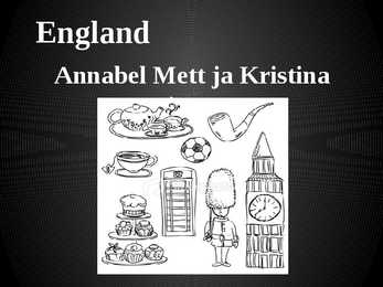
England Annabel Mett ja Kristina Smirnova 8.b Englands Geography · England is a part of the United Kingdom of Great Britain, its an island situated off the North West coast of Europe. · Bordered by Scotland in the north, the North Sea in the east, the England Channel in the south and Wales in the west. · Most of England is rolling hills. · Scafell Pike is the highest mountain in England with an elevation of 978 meters. Key Facts on England · Major Cities: London-Leeds-Liverpool-Manchester. · Capital: London with a population of 7,556,900. · Population: 51,446,000 inhabitants. · Geographic size: 130,395km². · National Anthem: None. God Save the Queen, Land of Hope and Glory. · Currency: Pound sterling (GBP). · Distribution: Males: 48,7% Females: 51,3% Climate of England · England has a temperate climate, with mild winters with tempe...
Estonia Estonia, officially the Republic of Estonia, is a state in the Baltic region of Northern Europe. It is bordered to the north by the Gulf of Finland, to the west by the Baltic Sea, to the south by Latvia, and to the east by Lake Peipus and Russia. Across the Baltic Sea lies Sweden in the west and Finland in the north. The territory of Estonia covers 45,227 km 2, and is influenced by a humid continental climate. The Estonians are a Finnic people, and the official language, Estonian, is a Finno-Ugric language closely related to Finnish, and distantly to Hungarian and to the Sami languages. The population of Estonia is 1.5 million. Of this number 62 per cent are Estonians. The geography of the land is surprisingly varied. Islands make up 9,2 per cent of Estonian’s total territory, the largest islands are Saaremaa, Hiiumaa and Vormsi. The highest point is Suur Munamägi, which is 317m...
New Zealand has an exceptionally long coastline compared to the size of the country (over 15,000 km) which makes it almost the same size as the mainland USA's coastline. Even though New Zealand is only about the same size as Colorado, the large coastline is possible because it is extremely iregular and indented. New Zealand's coastline is packed with deep coves, bays, intricate harbours, long sounds, and steep fiords. Its territorial waters stretch from the sub-tropical through to the sub-antarctic. Both islands tend to have better swimming beaches on their eastern coasts and the further north you go. The west coasts of both islands are quite rugged with cliffs and more unsettled weather. There are however some suitable swimming and bathing beaches here, with iron (volcanic) sand beaches (black sand) being common on the North Island. The longest beach in New Zealand is the 90 mile beach, which is actually about 60 miles long. This beach...
Michael Jeffrey Jordan Michael Jordan February 17, 1963 (age 51) University of North Carolina at Chapel Hill(3 seasons) joined the NBA's Chicago Bulls in 1984 "Air Jordan,, ; "His Airness,, 1991 first NBA championship with Bulls. Also in1922,1923. Dozens of individual awards Holds the NBA records for highest career regular season scoring average (30.12 points per game) 1999 greatest North American athlete Two brothers and two sisters Wife Juanita Vanoy (1989) Two sons and one daughter Yvette Prieto(2011); twin daughters named Victoria and Ysabel
Bears Uljana Brezgina Bears Bears are mammals of the family Ursidae. Bears are classified as caniforms, or doglike carnivorans, with the pinnipeds being their closest living relatives. Bears Black bears Black bears live in north America and central and eastern Asia. Black bears are smaller than brown bears. Black bears Polar bear Polar bears live near the north pole. They are good swimmers and the like to ride on pieces of ice. Polar bears eating fish , seals and birds. Polar bears Sun bears Sun bears live in southeast Asia And they live in trees. Sun bears ...
Estonia Estonia is a little country in Northen Europe. Estonia is borderd by the Baltic Sea and Gulf of Finland, it's between Latvia and Russia. Its geographic coordinates are 59 North 26 Eeast. Estonias capital is Tallin, it is situated in the North of Estonia. Estonias mainland terrain is flat, boggy, and partly wooded, offshore lie more than 1,500 islands. From the north flat and from the east is Estonia hilly. It's highest peak is Suur Munamägi(318 m). Sometimes flooding occurs in the spring in Estonia. It's biggest lakes are Lake Peipsi and Lake Võrtsjärv. It's biggest islands are Saaremaa and Hiiumaa. In Estonia there is 26.5% arable land, 0.35% permanent crops and 73.15% other land. Natural resources in Estonai are oil shale, peat, phosphorite, clay, limestone, sand, dolomite, arable land, sea mud. The population of Estonia is about 1,341,000 people. Estonia, as a new member of the Wor...
Estonia traditional costumes In Estonia traditional costume denotes mainly the festive peasant dress of the 19th century, which in its time referred besides social status also to national background, as the ruling class were mainly German at the time. The former peasant costume of regional variation has become today a national symbol and has turned due to its altered function into a national dress. Estonian country folk produced their clothing mainly from home-spun woollen or linen fabric: shirts and married women's head-wear was mostly made from linen, while various outer garments, gloves, stockings and socks, were made from wool. The majority of the clothes remained undyed for a long time: linen garments were bleached white, while woollen outer garments were mainly sheep-brown or black. The wool for making skirts was dyed with herbal dyes. The bedstraw root was particularly widely used to produce red colouring...
England The United Kingdom is very small compared with many other countries in the world. However there are only nine other countries with more people, and London is the world's seventh biggest city. When you travel about the country you can see how the scenery changes right in front of your eyes. Highlands turn into lowlands; forests and hills turn into meadows and plains very quickly. It's hard to believe, but in Great Britain one you can find practically any type of scenery. Britain is unusually beautiful country! England can be divided for four parts: the Southeast, the Southwest, East Anglia, the Midlands and the North of England. The Southeast is a highly populated region of England. London, the capital of the UK, and such historical cities as Windsor, Dover and Brighton are situated here. When people travel to Britain by sea or by air they...
Estonian teen How do you spend your free time? I’m usually quite busy after school. I go to my home eat and study for a while. Then I’m going to my training lesson every weekday and when it’s finished the time is half past seven and I have to finish my studying. I’m usually don’t have much free time. What do you like / dislike about living in Võru? I like Võru because it is a small city and the traffic is very light. I don’t have to walk very long to get one place to another. Do you get any pocket money? Yes, I have 10 euros for a month. I use it mostly to buy sweets because I love different sweats. What do you argue with your parent about most? I don’t argue with my parents lot. When I argue then mostly about how much do I have to study and why I don’t take school a much more serious. I really don’t have any reasons to argue with my parents because I like following rules. How is school life for ...
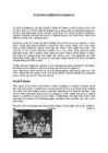
The United States of America (The U.S.A) Geography The main part of the United states extends from the Atlantic Ocean in the east to the Pacific Ocean in the west. It covers the middle of the North American continent. This area is called ,,the continental United states". The continental United States is bounded to the North by Canada and to the South by Mexico. The border with Canada is often called ,,the longest unguarded border in the world". The United States and Canada are good friends and they have very few problems in managing the border. The borded with Mexico is different. Immigrants are constantly crossing the border illegally. Every day about 2,000 of them are captured and sent back, but may others get through. There are also two states that are not connected to the continental United States. They are Alaska and Hawaii. There are two mountain ranges in ...
Names with and without the Names fot the streets/roads/squares/parks etc are without the: Union street Fifth avenue Piccadilly Circus Hyde Park Blackrock road Broadway Times Square Waterloo Bridge Many names (especially names of important buildings and institutions) are two words: Kennedy Airport Cambridge University The first word is usually the name of a person (Kennedy) or a place (Cambridge). We do not usually use ,,the" with names like these. Some more examples: Victoria Station Edinburgh Castle London Zoo Westminister Abbey Buckhingham Palace Canterbury Cathedral But we say 'the White House' and 'the Royal Palace' because 'white' and 'royal' are not names like 'Kennedy' and 'Cambridge' Most other names (of laces, buildings etc) have names with the: The + adjective or + noun ...
Tartu Kivilinna Grammar School Netherlands Report Composer: Reino Urbanovits Supervisors: Tiia Krass Erika Hunt Tartu, 2003 Table of contents Table of contents............................................................................................................................2 Introduction....................................................................................................................................3 Chapter 1........................................................................................................................................4 The Netherlands.............................................................................................................................4 Chapter 2.......
Italy Sicily Capital: Rome Size: 301,230 sq km Population: 57,6 million San Marino The Vatican City Highest point: Mont Blanc (4,807 m) The Alps in the north and the Apennines in the center of Italy The north of Italy: cold, harsh winters but hot and humid summers Central Italy: smaller temp. difference between summer and winter The south of Italy: warm and hot summers, mild winters Click to edit Master text styles Second level Sicily- Tonnara di Scopello Third level Gargano Fourth level Fifth level Sicily The biggest Italian island Breathtaking landscapes Nature Volcanoes Archaeological sites tell the story of Trinacria ...
GEOGRAPHY Estonia lies of the eastern coast of the Baltic sea. Total area of Estonia is approximately 45000 square kilometer and the population is about 1.5 million . Estonia is one of the most sparsely populated country in Europe. With 35 people per square kilometer. Nearly 1/3 of the nation live in the capital Tallinn. Along the coast of Estonia lies many bays and peninsulas. Lots of islands lie off the west- and north coast. The largest of them are Saaremaa and Hiiumaa. Geographically Estonia can be divided into 4 parts: North-, South-, West-, and East-Estonia. North-Estonia is relatively flat. Here is a nice coastline with coves, capes and a high coast. South-Estonia is more hillier, but there aren't any mountains or mountain ranges. The highest peak in Estonia is Suur Munamägi and its 318m above sealine. The largest industrial areas are situated in East-Estonia. There are beautiful nature parks in Wes...
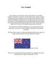
New Zealand New Zealand is on of the first countries in the world. It to be located southeast of australia.It consists of two main islands and a number of smaller outlying islands. New Zealand's two main components are the North Island and the South Island.The North Island is only half as big as the South Island, but nearly 75% of the population live on the North Island. About two-thirds of the south Island is covered with mountains. More than 220 mountains are higher than 2000 meters.The largest outlying island is Auckland. The capital of New Zealand is Wellington, it is the southermost national capital city in the world. It is New Zealand's sixth largest city behind the Auckland. The Flag of New zealand is a defaced blue Ensign with the union flag in the canton, and four red stars with white borders to the right. ...
Estonian geography The territory of Estonia covers 45,227 km2. Estonia is situated in the Baltic Region of Northern Europe. It is bordered to the north by the Gulf of Finland, to the west by the Baltic Sea. Its neighbor countries are to the south Latvia, to the east Russia, to the north and over the Gulf of Finland, Finland and to the west and over the Baltic Sea, Sweden. Most of the lowland areas are in the middle of Estonia. Average elevation reaches only 50 meters and the country's highest point is the Suur Munamägi in the southeast at 318 meters. There is 3,794 kilometers of coastline marked by numerous bays, straits, and inlets. The number of islands and islets is estimated at some 1,500. Two of them are large enough to constitute separate counties: Saaremaa and Hiiumaa. A small, recent cluster of meteorite craters, the largest of which is called Kaali is found on Saaremaa, Estonia. Estonia h...
Imperial War Museum Aire Albri Imperial War Museum in London. · Imperial War Museum is a British national museum organisation with branches at five locations in England, three of which are in London. · The museum was founded during the First World War in 1917 and intended as a record of the war effort and sacrifice of Britain and her Empire. · Today the museum gives its mission as "to enable people to have an informed understanding of modern war and its impact on individuals and society" · Originally housed in the Crystal Palace at Sydenham Hill, the museum opened to the public in 1920. · In 1924 the museum moved to space in the Imperial Institute in South Kensington, and finally in 1936 the museum acquired a permanent home which was previously the Bethlem Royal Hospital in Southwark. · The outbreak of the Second World War saw the museum expand both its collections and its terms of reference, but th...
Tallinna Tehnikakõrgkool EI 12 Madis Arula Introduction Laiuse Castle of Order Laiuse Drumlin Laiuse Blue Spring Põltsamaa Castle Põltsamaa Church Põltsamaa Rose garden Endla Nature Reserve Laiuse Castle of Order ·Rebuilt in the 15th century ·Destroyed 1700-1701, during the North war ·Swedish king Carl XII stayed there during the North war Laiuse drumlin ·10 kilometrs long ·2 kilometrs wide and ·Higest topp is 144 meters above the sea Laiuse blue spring ·18 m deep ·Healing qualities Põltsamaa castle and church ·Started in 1272 ·1770 the old building was replaced by a rococo palace ·Built from 1632 to 1633 ·In 1941 It catched fire and the renovation...
Rahvusvahelised organisatsioonid Euroopa liit- 27 riiki, poliitline majandusliit, prioriteet religioonse ebavõrdsuse vähendamine, toimib liikme maksudest WTO- world trade organisatsion- e maailma majandus org, eesmärgiks elatada maailma kaubandust, alandada tollijakaupade tariife NAFTA- north american free trade agreement- e põhja ameerika vabakaubandus leping, liikmesriigid on usa,kanada,mehhiko, kaubandus org- kaotatud pmst kõik kaubandus tõkked ASEAN- assocation of south east asian nations- e kagu aasia riikide ühendus, kaubanduslik org G20- lobal twenty- maailma juhtivad tööstusriigid, toimub igaastane tippkohtumine( maailma poliitika põhisuundade paika panekuks) MERCOSUR- south common market- e lõuna ühisturg, brasiilia,baraquai,uruqai,argentiina, vabakaubandus liit ÜRO- e ülemaailmne rahu, julgeoleku org., eesti alates 1991 NATO- north atlantic thesty org- e põhja atlandi lepingu org, 24 liikmesriiki(eesti 2003), sõjalispoliitilin...
Ireland Jaan Paljak Class 9 21.11.2011 Geography • The island of Ireland is located in the north-west of Europe, between latitudes 51° and 56° N, and longitudes 11° and 5° W. It is separated from the neighbouring island of Great Britain by the Irish Sea and the North Channel. • A ring of coastal mountains surround low plains at the centre of the island. climate The climate of Ireland can be summed up as being mild, moist and changeable with abundant rainfall and a lack of temperature extremes. The country receives generally warm summers and mild winters, and is considerably warmer than other areas on its latitude. This is due to the fact it lies in the Atlantic Ocean, and as a result is warmed by the Gulf Stream all year. tourist attractions Smarmore Castle Benburb Castle The National Galle ry of Ireland World Heritage Sites in Ireland ...
The United Kingdom and London United Kingdom is a political name of the United Kingdom of Great Britain and Northern Ireland. These political names include the countries of England, Scotland and Wales. Every country has its own capital and language. The capital of England is London, the people there are english and the language spoken is English. In scotland live the scots, capital is Edingburg and the languages spoken are English and Scottish. The capital of Wales is Cardiff, the people tehre are welsh and the languages spoken are welsh and English. N. Ireland is the home for the Irish, the capital is Belfast and the language is Irish. The first inhabitants were Iberians and Celts who settled on the land and were often at war with each other. In AD 43 Britain was made a Roman province. The romans stayed there for three hundred years. After the romans left came the Angles, Saxons and Jutes...
Canada is worlds... largest uranium supplier second richest country third largest diamond producer National symbols of Canada ice hokey maple lacrosse July the 1st 1881 first longdistance telephone call 1927 first radio broadcast 1958 television network 1980 "O Canada" Avarage Canadian is... hospitable tolerant following a live and let live philosophy with strong sense of community and duty Canadians invented basketball baseball glove lacrosse Lacrosse mix between soccer and hockey 10 players 3 attackmen, 3 midfielde, 3 defensemen and 1 goalkeeper Canada has worlds longest coastline onetenth of the worlds forests longest national highway in the world Great Slave Lake deepest lake in North America in the 1930s, there was discovered gold max depth of 614 m Canadian Rockies highest point is Mount Robso...
The Inuksuk Marit & Mari- Liis 9b symbol in the Arctic built from the stones "likeness of a person"( inimese sarnane) Used in many different ways. the way home warn of dangerous places showed where food was stored help hunt caribou herds (karjad) work of humans many Inuit lived on the sea ice stars in the night sky were important. Some Inuksuit were built to point toward the North Star Today much more than just a stone marker( kivid) symbol of the North and of leadership Traditional to mark their presence both in the Arctic and across this country. http://www.flickr.com/photos/aqaf33/6092241093/ http://www.pic2fly.com/Inutchuk.html http://www.google.ee/imgres? q=inutshuk&hl=et&biw=1680&bih=949&tbm=isch&tbnid= 5WUEz5RgVmQirM:&imgrefurl=http://aygues-vives- luzenac.com/En_Lesgites.htm&docid=gSyCFOShLKPK OM&imgurl=http://aygu...
Canada is the second largest country in the world. Situated to the north of the United States, in North America, it has both English and French as its official languages. Even though its area is bigger than that of the United States, its population is only about 11% of that of the USA some 35 million. Because of that, Canada has one of the lowest population densities in the world. The capital of Canada is Ottawa the name of whose comes from the old Algonquin language, with the original word meaning `to trade'. Due to the country's huge size and position, it is very diverse. It is bordered by the Pacific Ocean to the west, the Atlantic to the east, and the Arctic to the north. The landscapes differ greatly from rolling plains and mountains to the cold tundra in the northern part of the country. Geographically, the country's split into 5 major regions the Pacific, the Prairie Provinces, Central Canada, the Atlantic Provinces and...
History First people who lived in Canada came by a land bridge from Russia and Greenland. They were the ancestors of nowadays indigenous people of Canada. They just searched better for living places and followed their prey and they didn't even know they were on a different continent. The first explorers were Norse seafarers known as Vikings. As they sailed from Iceland to Greenland in AD 985, they were blown far off their course and they saw the coast what must have been Labrador. The forested areas of Canada's coast encouraged further explorations, because their settlement lacked lumber. They established a colony, what they called Vinland on Newfoundland. It died out during the 14th and 15th centuries. 500 years later Europeans started looking for a waterway to Asia, because travelling with spices over land wasn't very safe anymore. The first explorer was Christopher Kolumbus who reached America's shore in 1492, although he thought it ...
USA ajaloo konspekt (algus-Mayflower Compact) 1. Name the regions of the USA New England, Middle Atlantic, South, Midwest, Southwest, West. 2. Name the states that make up each region. NE: Maine, New Hampshire, Vermont, Massachutsess, Rhode Island, Connecticut. MA: New York, Pennsylvania, New Jersey, Maryland, Delaware. S: Virginia, North Carolina, South Carolina, Georgia, Florida, Alabama, Mississippi, Louisiana, Missouri, Arkansas, Kentucky, Tennessee, West Virginia. MW: North Dakota, South Dakota, Nebraska, Illinois, Michigan, Kansas, Minnesota, Iowa, Indiana, Wisconsin, Ohio. SW: Arizona, New Mexico, Texas, Oklahoma. W: Washington, Oregon, California, Hawaii, Alaska, Montana, Idaho, Nevada, Colorado, Wyoming, Utah. 3. Compare the geography and population / settlement and cultural background in the following regions: (any two of the 6 regions) Ne...
1.Which five areas does Highland Britain include? 1)Scotland 2)Wales 3)The Cornwall Peninsula 4)The Lake District 5)The Pennines 2.What is the highest top in Wales Snowdon 1,085m Scotland Ben Nevis 1,343m England Scafell Pike 978m How high is the highest mountain in the UK? Ben Nevis, 1,343m 3.Describe the relief of Scotland. Scotland is quite mountainous and there is also situated the highest peak in the UK, Ben Nevis. The Scottish Highlands cover the northern part of the country. Here The Northwest Highlands have rocky lunar landscape. South of Scotland is mostly covered with the Grampian Mountains which forms with some other mountains a huge mountain mass. The Central Lowland lie south of the Scottish Highlands. This region is a gently rolling plain. It has best farmland, and richest coal deposits. The Southern Uplands rise gently south of the Central Lowlands. This is a region of rounded, rolling hills. 4.What are the possibil...
France France is a country located in Western Europe, with several overseas islands and territories located on other continents. France is a unitary semi-presidential republic with its main ideals expressed in the Declaration of the Rights of Man and of the Citizen. Metropolitan France is bordered (clockwise from the north) by Belgium, Luxembourg, Germany, Switzerland, Italy, Monaco, Andorra, and Spain. France's overseas departments and collectivities also share land borders with Brazil and Suriname and the Netherlands Antilles. France is the largest country in the European Union by area and the second largest in Europe behind Ukraine. France has been a major power for many centuries with strong economic, cultural, military and political influence. During the 17th and 18th centuries, France colonized much of North America; during the 19th and early 20th centuries, It is the most visited cou...
MIS ON MANGROVE FOREST ÜLDSE? Mangrove swamps are found in tropical and subtropical tidal areas. Many mangrove forests can be recognized by their dense tangle of prop roots that make the trees appear to be standing on stilts above the water. This tangle of roots allows the trees to handle the daily rise and fall of tides, which means that most mangroves get flooded at least twice per day. The roots also slow the movement of tidal waters, causing sediments to settle out of the water and build up the muddy bottom. KAARDIGA SLAID Mangroves can be found in over 118 countries and territories in the tropical and subtropical regions of the world. The largest percentage of mangroves is found between 5° (degrees hääldad seda kraadi märki) North and 5° South latitudes.[20] Approximately 75% of world's mangroves are found in just 15 countries. Asia has the largest amount (42%) of the world's mangroves, followed by Africa (21%), North/Central Ameri...
The USA The United States of America (also called the United States, America, and the States) is a federal constitutional republic. The country is situated mostly in central North America, where its forty-eight contiguous states and Washington D.C., the capital district, lies between the Pacific and Atlantic Oceans, bordered by Canada to the north and Mexico to the south. The state of Alaska is in the northwest of the continent, with Canada to the east and Russia to the west across the Bering Strait. The state of Hawaii is an archipelago in the mid-Pacific. The country also possesses several territories in the Pacific and Caribbean. The United States is the world's oldest surviving federation. It is a constitutional republic and representative democracy. The government is regulated by a system of checks and balances defined by the U.S. Constitution, which serves as the country's supreme legal doc...
Tallinn English College Topic The United States of America Form Tallinn 2005 Introduction The United States of America is a very big country. Its territory is about 9.4 million square kilometres and its population is more than 260 million people, 12% of them are the Afro-Americans. It is the world's third-largest country by size and by population. The population density is about 27 people per square kilometre. Most of the people live in towns. There are 50 states in America. The biggest of the state is Texas, next by size are California, Alaska and Montana. Six states - Maine, Vermont, New Hampshire, Connecticut ,Rhode Island and Massachusetts are called New England. They are all small states in the U.S. that lie in the north-east. The first colony of immigrants settled down in Virginia, in the eastern part of the U.S.A. The...
Edinburgh Castle is an ancient stronghold which dominates the sky-line of the city of Edinburgh from its position atop Castle Rock. It is Scotland's second most visited tourist attraction. Human habitation of the site is dated back as far as the 9th century BC. As it stands today though, few of the castle's structures pre-date the Lang Siege of the 16th century, with the notable exception of St Margaret's Chapel, the oldest surviving building in Edinburgh, which dates from the early 12th century.As with all castles, Edinburgh's fortress has been a centre of military activity. As an ancient fortress Edinburgh Castle is one of the few that still has a military garrison, albeit for largely ceremonial and administrative purposes. The New Barrack Block is now home to the official headquarters of the Royal Regiment of Scotland and 52 Infantry Brigade, as well as home to the regimental museum of the Royal Scots and Royal Scots Dragoon Guards. ...
Table of contents 1. Introduction 2. Geographical position 3. Mountains, lowlands 4. Rivers, lakes 5. The territories and provinces 6. Towns, economy, agriculture 7. Climate 8. Animals, plantlife 9. Population 10. Sports 11. Culture 12. History 13. Political system, symbols 14. Conclusion 15. Materials 1. Introduction If you had to use two words to describe Canada, they might be large and diverse. Canada is the second largest country in the world, bordered by three oceans, and across the country, Canadians experience many different landscapes from rolling plains and mountains to the cold tundra of the north. Despite Canada's great size, it is one of the world's most sparsely populated countries. This fact, coupled with the grandeur of the landscape, has been central to the sense of Canadian national identity. 2. Geographical position Canada is the second largest country in the world after Russia. In the Arctic,...
William the Conqueror (~1028-1087) · Was born in Falaise , Normandy. It's not exactly known when William born but it is is believed to have been born in either 1027 or 1028.He was son of Robert I , the Duke of Normandy. He was known as "William the Bastard" because of the illegitimacy of his birth. · Duke of Normandy from 1035. By his father's will, William succeeded him as Duke of Normandy at age seven. He was knighted by Henry at age 15. By the time William turned 19 he was successfully dealing with threats of rebellion and invasion. · King of England from 1066 to his death. Upon the death of the childless Edward the Confessor, the English throne was fiercely disputed by three claimants--William, Harold Godwinson, the powerful Earl of Wessex, and the Viking King Harald III of Norway, known as Harald Hardraada. Ba...
Tartu Secondary School of Business New Zealand Report Kati-Liis Karu 10.A - I group TARTU 2009 Contents 1. Introduction ...................................................................................................3 2. Area. Population. Climate.........................................................................................4 3. Economy. Largest Cities........................................................................................5 4. Culture...........................................................................................................6 5. Conclusion .....................................................................................................7 6. References ..................................................................
Geography New Zealand is an island country in the Southwest Pacific Ocean. It lies about 1600 kilometres southeast of Australia, its nearest continental neighbour. New Zealand belongs to Polynesia, a large island group. The country consists of two main islands The North Island and the South Island and several dozen much smaller islands. The population is 4.1 million. New Zealand is a beautiful country of snowcapped mountains, green lowlands, beaches and many lakes and waterfalls. No place is more than 130 kilometres from the coast. Lakes, rivers, and waterfalls are found throughout New Zealand. Most of the lakes lie in the volcanic plateu of the North Island and in glacial valleys near the Southern Alps of the South Isaland. On both islands the rivers rise in the mountains and flow down to the sea. The rapid flow of New Zealand's rivers makes them important sources of hydroelectric power. New Zealan...
Territory and landscape Canada is one of the largest countries in the world. It covers nearly 4 million square miles. It is dividend into ten provinces( British Columbia, Manitoba, New Brunswick, Alberta, Nova Scotia, Ontario, Prince Edward Island, Quebec, Saskatchewan, Newfoundland ) along with two territories( the Yukon, the Northwest territories ). The capital city is Ottawa. Canada is a country rich in forests. It borders in the south with The United States and it's surrounded in the west by the Pacific Ocean, in the east by the Atlantic Ocean and above by many smaller bays, but is also borderedd with Alaska in the north-west. To the north of Canada is the broad Canadian Shield, an area of rock scoured clean by the last ice age, thinly soiled, rich in minerals, and dotted with lakes and rivers. Canada by far has more lakes than any other country and has ...
Estonia Where it is? Republic of Estonia is a state in the Baltic region of Northern Europe .It is bordered to the north by the Finland, to the west by the Baltic Sea, to the south by Latvia (343 km), and to the east by lake Peipus and Russia (338.6 km). Across the Baltic Sea lies Sweden in the west and Finland in the north. Towns Tallinn is the capital and the largest city of Estonia. It lies on the northern coast of Estonia, along the Gulf of Finland. There are 33 cities and several town-parish towns in the country. In total, there are 47 linna, with "linn" in English meaning both "cities" and "towns". More than 70% of the population lives in towns. History • Estonia was settled near the end of the last glacial era, beginning from around 8500 BC. Before the German invasions in the 13th century proto-Estonians of the Ancient Estonia worshipped the spirits of n...
The United States The country is situated mostly in central North America. The capital district, lie between the Pacific and Atlantic Oceans, bordered by Canada to the north and Mexico to the south. The United States is the third or fourth largest country by total area. It is one of the world's most multicultural nations. Food Slow-cooked pork and beef barbecue, crab cakes, potato chips, and chocolate chip cookies are distinctively American foods. The Ameri...
Christmas time The elves were very busy at the last Christmas. They ran around in the North Pole. In Santa's toy factory were busy times, because all gifts weren't finished. Also there were problems with reindeers, little elf Ville forgot to feed them and no they were ill. Santa was little bit upset. Ville was sad, he thought he ruined the Christmas, Ville wanted to make a gift for Santa. Elf boy Ville went to in to the deep forest, he had heard that in this forest live magical creatures who can fulfill your desires. Ville saw a bonfire behind the trees, he went there and he saw big giants dancing around the fireplace. Giants understood his concern. They told Ville:"You have to believe in themselves". Ville felt he got more strength inside him, he went back to North Pole. Ville fixed all broken toys, take care of reindeers, cleaned the rooms and put the sleigh ready. Santa was ready to ride and all gifts where in...
ENGLAND England is a country that is part of the United Kingdom. It shares land borders with Scotland to the north and Wales to the west; it is surrounded by the Irish Sea, the Celtic Sea, the North Sea and the English Channel, it's linked to Frane by the Channel Tunnel. The total area of the country is more than 130000 sq km. Most of England is lowland, but there are upland regions in the north, south and south west. The climate is temperate, subject to frequent changes, with plentiful rainfall all year round, although the seasons are quite variable in temperature, it rarely falls below -5 or rises above +30 degrees. The longest river, the Severn, flows for 354km. England's capital London, is the largest metropolitan area in the United Kingdom, drawing from a wide range of people, cultures and religions, speaking over 300 different languages, mixing their culture, tr...
Eesti Eesti laiub Läänemere idakaldal. Eesti kogupindala on ligikaudu 45 000 ruutkilomeetrit ja tema elanike arv on umbes 1,5 miljonit. Eesti on üks hõredamini asustatud riike Euroopas, ainult 35 inimest ruutkilomeetri kohta. Ligi kolmandik rahvastikust elab pealinnas Tallinnas. Piki Eesti rannajoont paikneb mitmeid lahtesid ja poolsaari. Lääne ja põhjakaldast eemal asuvad arvukad saared. Suurimad neist on Saaremaa ja Hiiumaa. Geograafiliselt saab Eestijagada neljaks : Põhja, lõuna, lääneja idaeestiks. PõhjaEesti on suhteliselt tasane ja madal. Siin on kena rannajoon abajate, neemede ja pankrannikuga. LõunaEesti on künklikum, kuid siin pole ühtegi mäge ega mäeahelikku. Eesti kõrgeim punkt SuurMunamägi on 318 m üle merepinna. Suurimad tööstuslinnakud asuvad IdaEestis. LääneEestis asuvad kaunid looduskaitsealad. Sisemaa on p...
Topic Canada Tallinn English College 2006 1. Introduction If you had to use two words to describe Canada, they might be large and diverse. Canada is the second largest country in the world with a territory of about 10 million square kilometers and it is bordered by three oceans: the Arctic, the Pacific and the Atlantic Oceans. The population of Canada is about 31 million people. About 77% of the people live in cities which lie in a band about 100 miles wide above the border of the United States. The capital of Canada is Ottawa. Other large cities are Montreal, Toronto, Vancouver, Winnipeg and Quebec. 2. Geographical position Canada is a huge country in the continent of North America. It is bordered with the Atlantic Ocean in the east, the Pacific Ocean in the west, the United States of America in the south and the Arctic Ocean in the north. Canada is a vast ...
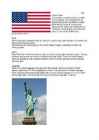
Tallinn English College English Anita Kuprijanovits Form 8b THE UNITED STATES OF AMERICA Report Supervisor: Mare Kallas Tallinn 2009 Introduction Name: The United States of America Area: ~10 mln km2 Population: ~300 mln people Symbols: The American Flag- consists of 13 equal horizontal stripes of red alternating with white and represent the Thirteen Colonies. The 50 small, white stars represent the 50 U.S. states. The U.S. flag is commonly called ,,the Stars and Stripes". The Statue of Liberty, that is locatd in New York,is a gift from the France. The Libety Bell, that is a bronze bell that symbolizes freedom in the United States of America. It is located in Pennsylvania,U.S. Capital: Washington D.C Biggest city: New York National language: English Location U.S is locat...
CANADA Canada is a vast country, second largest country of the world after Russia. It stretches from the Atlantic Ocean in the east to the Pacific Ocean in the west and to the Arctic Ocean in the North. Canada Covers most of the northern part of North America and its geography is very diverse. Canada's area is about 10 million square kilometers and its population is 31 000 000. Its capital is Ottowa and other main cities are Toronto, Montreal and Vancouver. Almost 75 % of canadians lives within 300 kilometer of the USA border, because the climate is softer in the South. 89 % of Canada is almost unhabited. Its official languages are English and French, but many other languages are spoken too. Like Italian, Chinese, German, Polish, Ukrainian, Dutch and Creek. There are also many native languages such as Algonquian. Most of the canadian's speak English (67 %), but French is very...
Western Australia Mihkel Hallen 8b Introduction · Western Australia is the largest state of Australia · It's population is 2,1 million inhabitants (10% of the national total) · The state's capital city is Perth The flag History · The first inhabitants of Australia arrived from the north approximately 40,000 to 60,000 years ago · The first European visited W.A. in 1616 · Population growth was very slow until the significant discoveries of gold were made in the 1890s Geography · Western Australia is bounded by South Australia and the Northern Territory to the east, and the Indian Ocean to the west and north · It's highest peak is the Mt Meharry (1249m) Climate · The southwest costal area is relatively temperate and was originally heavily forested, including large stands of the karri · Average annual rainfall varies from 300 ...
Report Title: ,,Frankenstein'' Author: Mary Shelley Genre: Novel Setting (time): 19th century Setting (place): North Pole, Europe (Switzerland, Scotland, England) Tone: magical, dark, mysterious, ghostly Themes: love, loneliness, science, human tendency Introduction Frankenstein was first published in March, 1818. This book is also known as The Modern Prometheus. Frankenstein is one of the most popular works of gothic horror and science fiction literature and it is considered to be one of the best known novels of English Romanticism. Characters Robert Walton: Walton is a well-educated sea captain who wants to explore the North Pole. He meets Victor there and then he writes Victor's story to his sister. Victor Frankenstein: A young man who is interested in science, chemistry and nature and he is the creator of the monster. Elizabeth Frankenstein: The wife of Victor and who is later ki...
Artikkel Artikkel puudub Määrav artikkel Isikunimed: Perekonnanimed mitmuses: Veiko the Tamms Tom Smith the Talvistes Riiginimed, kontinendid: Riigi või piirkonna nimed, mis on mitmuses Estonia või kus on täiendina pärisnimi, kingdom, France state või republic: Asia the United Kingdom = the UK Europe the United States of America = the USA = the US the Republic of Estonia the Estonian Republic the United Arab Emirates ...
USA General information is a federal constitutional republic comprising fifty states and a federal district The country is situated mostly in central North America, where its forty-eight contiguous states Capital: Washington D.C Largest city: New York City There isn't official language Currency: United States dollar ($) President: Barack Obama ( Barack Hussein Obama II) Flag Names: The Stars and Stripes, Old Glory, The Starry Banner Seal: Great Seal of the United States Motto: In God We Trust 9.83 million km2 and with over 308 million people, the United States is third largest country both by land area and population It is one of the world's most ethnically diverse and multicultural nations The U.S. economy is the world's largest national economy Click to edit Master text styles Second level Third level Fourth level ...
Irish History Tallinn 2009 Ireland is the third-largest island in Europe, and the twentieth-largest island in the world. It lies to the north-west of continental Europe and is surrounded by hundreds of islands and islets. To the east of Ireland, separated by the Irish Sea, is the island of Great Britain. Politically, the state Ireland (described as the Republic of Ireland) covers five-sixths of the island, with Northern Ireland, part of the United Kingdom, covering the remainder in the north-east. The first settlements in Ireland date from 8000 BC. By 200 BC Celtic migration and influence had come to dominate the island. Relatively small scale settlement by both the Vikings and Normans in the Middle Ages gave way to complete English domination by the 1600s. Protestant English rule resulted in the marginalisation of the Catholic majority, although in the north-east, Protestants were in the majority. A famine in the mid-1800s...