on raagus ja mõned üksikud taimed torkavad silma erksavärviliste õitega. 4 5 Joonis1-2. Saint Helensi asukoht. 6 Joonis3-4. 1980.aasta katastroof. 7 Joonis5-6. Mount Saint Helens. 8 Kasutatud kirjandus 1. http://volcano.wr.usgs.gov/cvo/current_updates.php 2. http://vulcan.wr.usgs.gov/Volcanoes/MSH/description_msh.html 3. http://vulcan.wr.usgs.gov/Volcanoes/MSH/May18/MSHThisWeek/510517/5 10517.htm 4. http://vulcan.wr.usgs.gov/Volcanoes/MSH/Images/MSH80/framework.html# may_18_1980 5. http://images.google.com/imgres? imgurl=http://www.gonorthwest.com/washington/cascades/mt_st_helens/im ages/StHelensJVC.JPG&imgrefurl=http://www.gonorthwest.com/washingto n/cascades/mt_st_helens/St_Helens.htm&usg=__vCOR81n7ZjkbCP8ysT5
vulkaan, mis võib ühel päeval taaskord katastroofi korraldada. Ohud Tänapäeval asub Vesuuvi jalamil Napoli linn, kus elab 2 miljonit inimest. Teadlased jälgivad vulkaani tegevust SUUR TÄNU TÄHELEPANU EEST Tänud abi eest emale ja isale Julia Kasutatud allikad: http://en.wikipedia.org/wiki/Mount_Vesuvius http://www.nga.gov/exhibitions/2008/pompeii/rediscovery.shtm# http://dsc.discovery.com/tv-shows/discovery-presents/videos/understanding- volcanoes-underwater-volcanoes.htm http://written-in-stone-seen-through-my-lens.blogspot.com/2012/09/hiking- mount-humphreys-of-san-francisco.html http://www.cotf.edu/ete/modules/volcanoes/vmtvesuvius.html
· Parmesan cheese originated in the area around Parma, Italy. Italians also created many other cheeses, including gorgonzola, mozzarella, provolone, and ricotta. No one knows when the pizza was invented, but the people of Naples made it populaar. · Most of Italy's natural flora and fauna has disappeared due to centuries of cultivation. Most of its natural wildlife has also disappeared due to over-hunting · No other country in Europe has as many volcanoes as Italy. This is because the Italian peninsula stands on a fault line. Three major volcanoes (Etna, Stromboli, and Vesuvius) have erupted in the last hundred years · The world's first operas were composed in Italy at the end of the sixteenth century. HOLLAND/ Neatherland · Holland has the highest museum density in the world, with almost 1000 museums. The Van Gogh Museum and the Kröller-Müller Museum of Holland house the largest
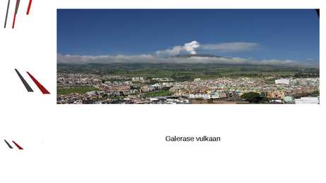
Galerase vulkaan Asend Colombia edelaosas 4276 meetrit kõrge Pursked Esimene purse 560 000 a. tagasi Esimene registreeritud purse 1580 14. jaanuar 1993, 9 hukkunut Oht inimestele Katab külasid ja linnu tuhaga Allikad http://et.wikipedia.org/wiki/Galerase_vulkaan http://www.volcanodiscovery.com/galeras.html http://geology.com/volcanoes/galeras/ http://en.wikipedia.org/wiki/Galeras
My Dream Destination Bora Bora Islands Where is Bora Bora? Bora Bora ● Major tourist destination ● By 2008 population of 8,800 ● Very warm ● Beautiful nature Nature ● Water ● Volcanoes ● Corals ● Lagoon ● Mountains Pictures Things to do ● Snorkle ● Scuba Dive ● Surf ● Waterski ● Jetboat tours ● Parasailing ● 4x4 Safari tour ● Shark feeding Pictures Used links ● http://www.worldatlas.com/webimage/countrys/is lands/pacifics/borabora.gif ● http://www.welt-atlas.de/datenbank/karten/karte- 3-346.gif ● http://media.web.britannica.com/eb-media/16 /60016-004-E02EBE3E.jpg
Hawaii Maria Kesvatera 2012 Information · Capital city:Honolulu · Population:1,374,810 · Flag · Flower of the state: hibiscus · Nickname:Aloha State Where? Hawaii Intresthing places to visit · Honolulu Zoo · Hilo Tropical Gardens · Relax on Hawaii's world famous beaches Nature and Landscape · Waimea Canyon, Kauai · Volcanoes National Park, Hawaii · Oahu beach Famous People · Nicole Mary Kidman · Israel Kamakawiwo'ole · Jean Erdman Traditions · Aloha Festivals · Waikiki Hoolaulea · Royal Court Investiture Something intresting · More than one-third of the world's commercial supply of pineapples comes from Hawaii. · Hawaii is the only state that grows coffee. · The state of Hawaii consists of eight main islands: Niihau, Kauai, Oahu, Maui, Molokai,
The outer planets are Jupiter Saturn Uranus Neptune Pluto 3)Where is the asteroid belt situaded? The asteroid belt is situaded between inner planets and outer planets. 4) 5)Describe one of the inner planets of our solar system? Mars is seen as a reddish star in the night sky.The surface is reddish-brown,desertlike.The Viking probes that landed on Mars found rocky surface with vast plains and volcanoes and no evident traces of life.Mars has changes in season.Its seasons are twice as long as Earth`s.Large caps of frozen fluid melt and refreeze over poles as the seasons pass
twice the size of Texas, the next largest state. Alaska is larger than all but 18 sovereign countries. Counting territorial waters, Alaska is larger than the combined area of the next three largest states: Texas, California, and Montana. It is also larger than the combined area of the 22 smallest U.S. states. 3 Natural features With its myriad islands, Alaska has nearly 54,720 km of shoreline. Many active volcanoes are found in the Aleutians and in coastal regions. The chain of volcanoes extends to Mount Spurr, west of Anchorage on the mainland. Geologists have identified Alaska as part of Wrangellia, a large region consisting of multiple states and Canadian provinces in the Pacific Northwest which is actively undergoing continent building. One of the world's largest tides occurs in Turnagain Arm, just south of Anchorage tidal differences can be more than 35 feet.
Click to edit Master text styles Second level Sicily- Tonnara di Scopello Third level Gargano Fourth level Fifth level Sicily The biggest Italian island Breathtaking landscapes Nature Volcanoes Archaeological sites tell the story of Trinacria Etna 3330 meters Highest active volcano in Europe Used sources: http://www.littleexplorers.com/europe/italy/ http://www.cherrychapman.com/2013/03/12/thrill-seekers-and-death-on-mont-blanc/ http://www.italia.it/en/useful-information/the-climate-in-italy.html http://www.lolhostel.com/hostel-syracuse/etna.html
Ends with -f Change f to v then Add -es half - halves wolf - wolves loaf - loaves Ends with -o Add -es potato potatoes tomato - tomatoes volcano - volcanoes ends with -us Change -us to -i cactus - cacti nucleus - nuclei focus - foci ends with -is Change -is to -es analysis - analyses crisis - crises thesis - theses
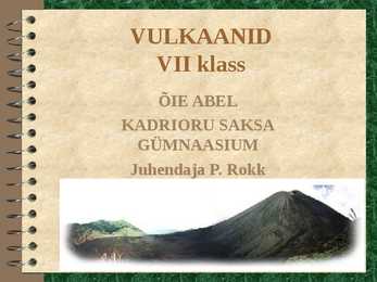
VULKAANID VII klass ÕIE ABEL KADRIORU SAKSA GÜMNAASIUM Juhendaja P. Rokk VULKAANID VII klassis maakoore teema käsitlusel: mõiste tekke põhjus ehitus jaotus levi hilisvulkaanilised nähtused VULKAAN ehk TULEMÄGI Enamasti koonusekujuline mägi,mis aeg-ajalt purskab (või on kunagi pursanud) laavat, kuumi gaase, kivimitükke, tuhka. TEKKEPÕHJUSED Kui maakoores juhtub olema mingi lõhe või avaus, siis hakkab magma suure rõhu mõjul seda pidi ülespoole kerkima. VULKAANI EHITUS tuhk lõõr kraater magma magma kolle Vulkaanid jaotatakse väliskuju järgi KUHIKVULKAAN KILPVULKAAN näiteks Etna näiteks Mauna Loa VULKAANID LEVIVAD LAAMADE PIIRIALADEL VULKAANIDKI VÄSIVAD HILISVULKAANILISED NÄHTUSED: KUUMAVEEALLIKAD GEISRID GAASIDE ERITUMINE GEISER GEISER ON KUUMAVEEALLIKAS, MIS AEG-AJALT PURSKAB KUUMA VETT JA AURU ...
Biggest rivers Glomma, Otra Famous for - 19th century, Hendrik Ibsen made Norway famous for plays Landscape rugged coastline, mountains, fjords Republic of Iceland Capital - Reykjavik Language Icelandic, fluent English Size 103,000 square kilometers Population 299,000 Flag - blue, red Scandinavian cross outlined in white Iceland is a volcanic island in the North Atlantic Ocean Nature volcanoes, lava fields, waterfalls, geysers and hot pools Kingdom of Denmark Capital - Copenhagen Language - Danish Size 43,094 square kilometers Population 5,564,219 Flag red,white Scandinavian cross Emblem 3 crowned lions Symbols swan, red clover, beech Denmark is called the home of the Vikings Famous writer H.C.Andersen, meremaid statue, football stadium, art galleries
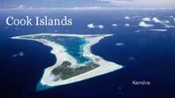
Cook Islands Kendra Location Capital: Avarua South Pacific Ocean 15 islands, 9 main islands Rarotonga Area: 240 square km Time zone: 12h behind Associated: New Zealand Geography Capital: Avarua Divided into two Coastline: 120km Natural resources: coconuts Climate: Tropical Mountainous, volcanoes, palms, soils, caves, People European, Chineese, African settlers Polynesian roots 2 polynesian languages: Pukapuka and other islands Official language Cook Islands Maori, English Population: 14,974 Villages, farms Politics Left: Henry Puna, right: John Key Self-governing state In international treaties Head of state: British monarch Parliamentary elections: 4 years Independence: 4th August 1965 Political parties: Cook islands party, the Democratic Economy
Estonia is the place where i live and i like to live in here. There are many reasons why i like to live in Estonia, but the main reason is that the Estonia is naturally great place where to live. Estonia has got very beatiful nature where we can go hiking or fishing. There are many great places wich you can visit in nature. In nature you can do a lot of things. It also attrackts many tourists. Estonia is also naturally quiet place, in here we don´t have volcanoes, earthquakes, tornadoes or other dangerous natural phenomenas. So we don´t have to worry about that in one beautiful day our house fly away by tornado or volcano burns it down. People don´t have to live in fear and in here they dont mus´t worry about natural disasters. Other good thing is that we don´t have dangerous or poisonous wild animals in nature. So we don´t need worry about that a monkey jumps trough our window and arranges a big mess or wild animal attacks people
kanaari mändi · Loomariigist elavad seal vaid jänesed ja sisalikud · Teide vulkaani jalamil asuv 1945. aastal avatud Las Canadase rahvuspark on meelisatraktsioon nii turistidele kui ka kohalikele · Päris vulkaani kraatri servale saab minna nii köisraudteega kui matkagrupiga Kasutatud materjalid: · http://volcano.oregonstate.edu/volcanoes/volc_images/africa/tenerife.htm · http://www.ap3.ee/Default2.aspx?PaperArticle=1&code=2069/rpp_tur · http://upload.wikimedia.org/wikipedia/et/7/7f/Laamade_nimed.gi f · http://images.google.ee/images? hl=et&lr=&um=1&sa=3&q=teide+vulkaan&btnG=Otsi+pilte · http://horizontravel.ee/? event=Show_booking_subpage&page_id=1588&destination=7
The history of the Philippines is believed to have begun with the arrival of the first humans using rafts or primitive boats, at least 67 000 years ago In 1521, Portuguese explorer Ferdinand Magellan arrived in the Philippines and claimed the islands for Spain In 1935, the Philippines was granted Commonwealth status On July 4, 1946, the Philippines attained it's independence Intresting facts There are more than 200 volcanoes, though only a few are active The Philippine flag is the only flag in the world which is hoisted upside-down when the country is in war The Philippines covers an area of 115,830 square miles, making it equal in size to Italy Usually Filipinos drive on the right side of the road but sometimes you will find that they are driving on the left or maybe just in the middle
located in Italy. Mount Blanc is 4807m high. The independent states of San Marino(61 km2) and the Vatican City (44 hectares) are enclaves within Italy. Vatican City is the only country in the world, which close own gates for every night . Inhabitants of Vatican have own radio and TV, currency and postage stamps. San Marino is the oldest republic in the world and it has less than 30 000 inhabitants. There are 14 volcanoes in Italy, four of which are active: Etna, Stromboli, Vulcano and Vesuvius. Etna is also the activiest volcano in the world. 60% of cultural world heritage is in the Italy Venice is a city in northeast Italy sited on a group of 118 small islands separated by canals and linked by bridges. Venice is renowned for the beauty of its setting, its architecture and its artworks. The city in its entirety is listed as a World Heritage Site, along with its lagoon.
main vent- Lõõri mööda liigub magma kõrgemale, kui rõhk magmakoldes tõuseb Kasutatud kirjandus · http://www.photoglobe.info/earth_from_space/img/map_mt_etna.jpg · http://www.annaabi.com/search.php?s=etna+vulkaan · http://www.iris.edu/seismon/ · http://www.ohtuleht.ee/index.aspx?id=244691 · http://www.volcanoetna.com/gallery/d/3675- 2/mount+etna+eruption+1989+Copyright+__+Boris+Behncke+Italy+Volcanoes+_6_.jpg · http://www.addictedtotravel.com/Resources/Images/Cache/2008/2/028f8a817388402ab7c04 f1b97deb922-350-350_350 · http://rst.gsfc.nasa.gov/Sect2/VolcanoStructure.jpg · Lea Koppel, Ülle Liiber, Ene Saar ,,Geograafiaõpik põhikoolile'' 2008
kilometers into the air. Eruption killed three people and forced 100,000 people to evacuate the area. Mount Kelud, what is 1,731 meter high, had been rumbling for several weeks and was under close observation. The disaster agency said that volcano had spewed millions of cubic meters of debris into the air. Breathing was painful, because ash hung so thickly in the air. 3. Scientists have discovered how lava dome volcanoes erupt and thanks to that they can predict how volcanic eruption will behave. They have discoverd that frictional melting helps predict how a vulcano will erupt. Frictional melting generates stick-slip process what causes rhythmic small earthquakes. Frictional melting takes place when large tectonic earthquakes occur. The ultimate goal is to start predicting when or where vulcano is going to start erupting. Voc. 1. Volcanic eruption-vulkaanipurse 2
There are strong winds at the cloud tops but winds at the surface are very slow, no more than a few kilometers per hour. The surface of Venus retains a constant temperature between day and night and between the equator and the poles. We can't see the surface of Venus from Earth, because it is covered with thick clouds that strongly reflect sunlight. However, space missions to Venus have shown us that its surface is covered with craters, over 1600 major volcanoes, mountains, large highland terrains, and vast lava plains. Venus is usually visible with the unaided eye. On June 8 2004, Venus passed directly between the Earth and the Sun, appearing as a large black dot travelling across the Sun's disk. This event is known as a "transit of Venus" and is very rare: the last one was in 1882, the next one is in 2012 but after than you'll have to wait until 2117. Venus orbits the Sun at an average distance of about 108 million km, and rotates once every 243
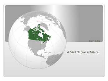
monarchy The sovereign is Queen Elizabeth II, who also serves as head of state of 15 other Commonwealth countries and each of Canada's ten provinces People Justin Bieber is a singer from Canada Jim Carry, Ellen Page, Ryan Gosling and Myke Myers are some of the famous movie acters from Canada Deadmau5 is a famous DJ from Canada Nature Canada has a very various landscape Canada has around 31,700 large lakes Canada is geologically active, having many earthquakes and potentially active volcanoes The national animals in Canada are beaver and canadian horse Culutre and traditions Historically, Canada has been influenced by British, French, and aboriginal cultures and traditions Many Canadians value multiculturalism and see Canada as being inherently multicultural Popular food is French fries with maple syrup National sport is ice hokey Famous sights are Lake Louise, Banff and Montreal Interesting facts Canada is the second largest country in the world
Atacama -- in the north, through a Mediterranean climate in the centre, to a snow-prone Alpine climate in the south, with glaciers, fjords and lakes. The Pacific forms the country's entire western border, with a coastline that stretches over 6,435 kilometres. Chile expanded in the late 19th century, when it incorporated its northern and southern regions. Southern Chile is rich in forests and grazing lands and features a string of volcanoes and lakes. The southern coast is a labyrinth of fjords, inlets, canals, twisting peninsulas, and islands. Prior to the coming of the Spanish in the 16th century, northern Chile was under Inca rule while the indigenous Araucanians inhabited central and southern Chile. Although Chile declared its independence in 1810, decisive victory over the Spanish was not achieved until 1818. Currently, Chile is one of South America's most stable and prosperous nations.
Vulkaan Etna Asukoht: Vulkaan Etna asub Itaalias, Sitsiilia idaranniku lähedal. See vulkaan asub Catania ehk siis Sitsiilias suuruselt teise linna lähedal. Etna asub Aafrika laama ja Euraasia laama kokkupõrkekohal. Seal sukeldub üks laam teise laama alla, seetõttu esineb seal vulkanismi ning vähesel määral ka maavärinaid. Aktiivsus: Etna on üks akt...
One of the most interesting sight is Jägala waterfall. The largest Lake called Peipsi separates Estonia from Russia. The biggest river basin is around the Pärnu river. There are very large forested areas in Estonia and wood is an important export article. Unfortunately is Estonia quite poor in other natural resources. The main mineral resources are sand, limestone and shale. The climate in Estonia is moderate, but hinterland winters are pretty rough. Fortunately, the volcanoes, hurricanes, floods and eartsquakes have no threats to Estonia. Estonia is a democratic parliamentary republic and is devided into fifteen counties. The Parliament of Estonia is called Riigikogu. The Riigikogu elects and appoints several high officials of the state, including the President of the Republic.
world's higher (vascular) plants grow on the island's productive soils. 3 Geography Papua New Guinea consists of over 600 islands and lies in the middle of the long chain of islands stretching from mainland South-East Asia. The mainland and larger islands are mountainous and rugged, divided by large fertile upland valleys. Fast- flowing rivers from the highlands descend to the coastal plains. A line of active volcanoes stretches along the north coast of the mainland and continues on the island of New Britain. To the north and south of this central mountain range on the main island lie vast stretches of mangrove swamps and coastal river deltas. /1/ Volcanoes and thermal pools are also found in the southeast of other islands. Papua New Guinea offers the greatest variety of terrestrial ecosystems in the South Pacific, including five types of lowland rainforest, 13 types of
Capital, Largest City Since the end of the last glacial period, Canada has consisted of eight distinct forest regions, including extensive boreal forest on the Canadian Shield Canada has more lakes than any other country, containing much of the world's fresh water Geography There are also freshwater glaciers in the Canadian Rockies and the Coast Mountains Canada is geologically active, having many earthquakes and potentially active volcanoes, notably Mount Meager, Mount Garibaldi, Mount Cayley, and the Mount Edziza volcanic complex The volcanic eruption of the Tseax Cone in 1775 was among Canada's worst natural disasters, killing 2,000 Nisga'a people and destroying their village in the Nass River valley of northern British Columbia The eruption produced a 22.5kilometre (14.0 mi) lava flow, and, according to Nisga'a legend, blocked the flow of the Nass River
chills. In non-coastal regions, snow can cover the ground almost six months of the year (more in the north). On the east and west coast, average high temperatures are generally in the low 20s °C (70s °F), while between the coasts the average summer high temperature ranges from 25 to 30 °C (75 to 85 °F) with occasional extreme heat in some interior locations exceeding 40 °C (104 °F). Canada is also geologically active, having many earthquakes and potentially active volcanoes, notably Mount Meager, Mount Garibaldi, Mount Cayley and the Mount Edziza volcanic complex. Economy Canada's main economic resources are minerals( nickel, uranium ), timber( the wood from its forests ), grain, petroleum and natural gas. Canada is one of the world's most important suppliers of agricultural products, with the Canadian Prairies one of the most important suppliers of wheat, canola and other grains
measuring the amount of acid in the water and liquid. The pH scale ranges from 0 to 14 with lower pH being more acidic while a high pH is alkaline; seven is neutral. Normal rain water is slightly acidic and has a pH range of 5.3-6.0. Acid deposition is anything below that scale. It is also important to note that the pH scale is logarithmic and each whole number on the scale represents a 10-fold change. Causes and History of Acid Rain Acid deposition can occur via natural sources like volcanoes and rotting vegetation but it is mainly caused by the release of sulfur dioxide and nitrogen oxide during fossil fuel combustion. When these gases are discharged into the atmosphere they react with the water, oxygen, and other gases already present there to form sulfuric acid, ammonium nitrate, and nitric acid. These acids then disperse over large areas because of wind patterns and fall back to the ground as acid rain or other forms of precipitation.
2 km2 ) rahvuspark Aafrikas Serengetis Tanzanias, mis on rajatud 1951. aastal. Põhi asukateks on seal lõvid, leopardid, elevandid, mustad ninasarvikud ja aafrika pühvlid lisaks paljudele teisetele loomaliikidele. (7) El Yunque National Forest On vihmametsa looduspark, mis asub Puerto Rico saarel, suuruseks on tal 28,002 aakrit ehk 113.32 km² ja asutatud on ta aastal 1903. Aastas võib seal sadada kuni 6m vihma ehk 380 000 000 m³, terve metsa peale. (8) Volcanoes National Park Park asetseb loode Rwanda's ja on kõrvuti Virunga Rahvus Pargiga, mis asub Congo Demokraatlikus vabariigis, ja Mgahinga Gorilla Rahvus Pargiga, mis asub Uganda's. Rahvuspark on tuntud kui paradiis mägi gorilladele. Samuti on see koduks viiele kaheksast vulkaanist, mis on Virunga mägedes (Karisimbi, Bisoke, Muhabura, Gahinga ja Sabyinyo), mis nüüdseks on kaetud vihmamesa ja bambusega. Park avati aastal 1929 hõlmates juba siis tohutut maaala suurusega 19 298 090 km². (9)
The country extends more than 1600 kilometers along its main,north - north-east axis and has about 15,000 kilometers of coastline. The South Island is the largest land mass of New Zealand and is divided along its lenght by the Southern Alps and the highest mountain Mount Cook is 3,754 meters high. There are 18 peaks over 3000 meters in the South Island. The highest North Island mountain is Mount Ruapehu and it is an active cone volcano. There are also two other volcanoes in the centre of the North Island. Cook Strait, 20 kilometers wide at its narrowest point, separates the North and South Islands. The climate throughout the country is mild and temperate, mainly maritime, with temperatures rarely falling below 0 'C or rising above 30 'C in populated areas. its isolation from continental (influences and exposure to cold southerly winds and ocean currents) give(s) the climate a much milder character
NEW ZEALAND Geography: New Zealand is situated midway between the Equator and the South pole in the southern Pacific Ocean. It consists of two large islands, North Island and South Island, plus several smaller ones of which Stewart Island is the largest. North and South Islands are separated by the 32km wide Cook Strait. The total land area is 270,535 sq Km, about the size of Italy, the United Kingdom or the US state of Colorado. North Island is volcanically active with three active volcanoes. South Island has the high snow covered mountain peaks and glaciers of the Southern Alps, a range running almost 500Km along the Island. The longest river is the Waikato on North Island (425 Km), the largest inland stretch of water is Lake Taupo also on North Island (607 sq Km) and the highest point is Mount Cook on South Island (3754 m). Over 75% of New Zealand is above 200m. Land use is broken down to about: forested 30% - meadows and pastures 50% - agricultural and
Cerro Mohinora 3 992 m üles Sierra Madre Oriental Sierra Madre Oriental on mäeahelik, mis asetseb lõunasunas läbi Mehhiko idaosa, olles paralleelne Mehhiko lahega. See on keskmiselt 360 kilomeetrit lai, kuid sealsed mäed on suhteliselt madalad ja ilma kuulsate tippudeta. Sealne kõrgeim mägi, Cerro Peña Nevada (3664 m), on tuntud oma koobaste poolest. Mexico's three highest peaks, all isolated volcanoes, rise south of the Sierra Madre Oriental, and are sometimes considered part of the Sierra Madre Occidental. Kariibi mäed Läbi Kariibi mere saarte on kenad mäed, millesse kuuluvad ka Jamaika Sinised Mäed (Blue Mountains), Kuuba Sierra Maestra ja Puerto Rico vihmametsadega kaetud Sierra de Luquillo. Kõrgemad mäed Kariibi saartel on Hispaniola saarel, mille mäed on kõrgemad kui Haiiti ja Dominikaani osade mägedest. Dominikaani Vabariigis on
on the Pacific coast between Washington to the north, California to the south, Nevada on the southeast and Idaho to the east. The area was inhabited by many indigenous tribes before the arrival of traders, explorers and settlers. · The Oregon Territory was created in 1848 after American settlement began in earnest in the 1840s. Oregon became a state (33rd) on February 14, 1859. · Oregon enjoys a diverse landscape including a scenic and windswept Pacific coastline, the volcanoes of a rugged and glaciated Cascade Mountain Range, dense evergreen forests, and high desert across much of the eastern portion of the state. · The towering Douglas firs and redwoods along the rainy Western Oregon coast provide a dramatic contrast with the lower density and fire prone pine tree and juniper forests covering portions of the Eastern half of the state. The eastern portion of the state also includes semiarid scrublands, prairies, deserts, and meadows
laavavool 23. mudavool 24. Atmosfääri paisatakse gaase, tuhka 25. Maavärinad 26. väävel Kodus: Mõtle ja vasta vihikusse: Kas vulkaanide näol esinevat ohtu on võimalik vähendada, vältida? Lisamaterjalina saab kasutada: 27. Arold, I., Raukas, A., Viiding, H., Geoloogia alused. Tallinn: Valgus 1987 28. Terra . Toimiva maapallo. Ihminen ja Ympäristö. WSOY. 1994 29. National Geographic 05.1984 Herculaneum, 12.1992 Volcanoes 30. EE köide 6 lk. 56 Maa geosfääride areng( saab näidata vulkaanilise aktiivsuse muutusi aja jooksul) 31. L. Saveljev. Jäljed kivil. RK" Teaduslik kirjandus" Tartu 1947 32. http://volcano.und.nodak.edu/
in 1713, Newfoundland, Hudson Bay, and Nova Scotia (Acadia) were lost to England. During the Seven Years' War (17561763), England extended its conquest, and the British general James Wolfe won his famous victory over Gen. Louis Montcalm outside Quebec on Sept. 13, 1759. The Treaty of Paris in 1763 gave England control. Nature: Canada is also geologically active, having many earthquakes and potentially active volcanoes. The volcanic eruption of Tseax Cone in 1775 caused a catastrophic disaster, killing 2,000 Nisga'a people and the destruction of their village in the Nass River valley of northern British Columbia; the eruption produced a 22.5-kilometre (14.0 mi) lava flow, and according to legend of the Nisga'a people, it blocked the flow of the Nass River. As of 2008, there are 36 National Parks and six National Park Reserves.. The biggest natural parks are Banff National Park, Gros Morne National
com/earthquake1.htm (vaadatud 15.02.2008) 5. www.hot.ee/geo120/litosf22r.doc (vaadatud 15.02.2008) 6. http://e-maailm.hot.ee/reaal120/images/24/2.rtf (vaadatud 15.02.2008) 7. http://lepo.it.da.ut.ee/~arps/maateadus/MT_maavarinad_seismika.htm (vaadatud 16.02.2008) 8. http://www.geography-site.co.uk/pages/physical/earth/cause.html (vaadatud 16.02.2008) 9. http://www.madsci.org/posts/archives/2001-12/1009228703.Es.r.html (vaadatud 16.02.2008) 10. http://www.geo.mtu.edu/volcanoes/hazards/primer/eq.html (vaadatud 16.02.2008) 11. http://allshookup.org/quakes/etypes.htm (vaadatud 16.02.2008) 12. http://www.miksike.ee/documents/main/elehed/7klass/5geoloogia/7-5-18-1.htm (vaadatud 16.02.2008) 13. http://blog.wired.com/wiredscience/2007/01/people_can_caus.html#comment- 27353098 (vaadatud 16.02.2008) 14. http://encarta.msn.com/encyclopedia_761571674_2/earthquake.html (16.02.2008) 15. http://www.olympus.net/personal/gofamily/quake/causes.html (vaadatud 16.02.2008)
FIND OUT 5 WAYS HOW TO STOP DEFORESTATION. 7. Ocean Acidification: It is a direct impact of excessive production of CO2. 25% of CO2 produced by humans. The ocean acidity has increased by the last 250 years but by 2100, it may shoot up by 150%. The main impact is on shellfish and plankton. Acid Rain: Acid rain occurs due to the presence of certain pollutants in the atmosphere. Acid rain can be caused due to burning of fossil fuels or erupting volcanoes or rotting vegetation which release sulphur dioxide and nitrogen oxides into the atmosphere. Acid rain is a known environmental problem that can have serious effect on human health, wildlife and aquatic species. FIND OUT 5 WAYS HOW TO REDUCE OCEAN ACIDIFICATION AND 5 WAYS THAT WOULD HELP TO PREVENT ACID RAIN POLLUTION. 8. Water Pollution: Clean drinking water is becoming a rare commodity. Water is becoming an economic and political issue as the human population fights for this resource
Australia is a federation just like the USA but it has a monarch and the government is chosen from the majority party of the Parliament. 8. At the referendum of 1999, Australians decided whether they wanted to become a republic or not. 55% were against the idea. 9. The native people of Australia are the Aborigines and they live in every state but mostly in remote areas. New Zealand 1. The two large islands of New Zealand are the North Island (a lot of volcanoes) and The South Island (Alps, Mount Cook, and Fjord land). 2. The Native people of New Zealand are known as Maoris. They originate from Polynesian islands. They arrived in New Zealand circa 1200 AD. 3. In 1642, Abel Tasman was the first European to explore New Zealand. In 1789, James Cook arrived and explored the coastline and claimed it. 4. Maoris gave up the sovereignty of New Zealand to Britain by the Waitangi Treaty in 1840. 5
Paleozoic formations; and the Southern Uplands, which lie south of a second fault line, are largely composed of Silurian deposits. The existing bedrock includes very ancient Archean gneiss, metamorphic beds interspersed with granite intrusions created during the Caledonian mountain building period (the Caledonian orogeny), commercially important coal, oil and iron bearing carboniferous deposits and the remains of substantial tertiary volcanoes. During their formation, tectonic movements created climatic conditions ranging from polar to desert to tropical and a resultant diversity of fossil remains. Scotland has also had a role to play in many significant discoveries such as plate tectonics and the development of theories about the formation of rocks and was the home of important figures in the development of the science including James Hutton, (the "father of modern geology") Hugh Miller and Archibald Geikie. Various locations
The highland regions are the Appalachians in the east and the Cordilleras in the west. The Appalachians run parallel to the Atlantic coast from the Gulf of Mexico to Canada; the highest peak is 2000 m high. The Cordilleras run along the Pacific coast with the Sierra Nevada in the south and the Rocky Mountains in the north; the highest peak is Mt. Whitney (4,540 m) in the Sierra Nevada. The Cordilleras are still an active region of the Earth. There are a number of active volcanoes there and often earthquakes shake the land. Hot springs and geysers are numerous in Yellowstone. Between the mountains there are many canyons. The most famous of them is probably the Grand Canyon. The highest peak in America is Mt. McKinley with its 6194m. The lowest point is the Death Valley - 86m. Between the mountains are the central lowlands called the prairie and eastern lowlands called the Mississippi valley.
sentences and broken metre. Metaphysical influence The influence of the 17th cent Metaphysical poets can be seen in the intensity of the emotions she expressed and her use of startling metaphors. Inner struggle and nature Her poetry often reveals a painful inner struggle that may have been caused by religious doubt. Although she could not accept the doctrines of orthodox religion, she seemed to long for the comforts of unquestioned faith. Hers is the poetry of funerals, volcanoes, storms and shipwrecks, but it is also the poetry of butterflies, birds and sunrays. Her ability to capture in words the smallest detail of nature was one of her greatest talents. Reputation Initially she was considered to be an eccentric minor poet. Today she is regarded as one of the outstanding poets of the 19 th cent and a major influence on the poets of the 20th cent. Walt Whitman (1819-1892) Life Early jobs He was born into a working class family on Long Island, New York
Canada is the second-biggest country in the world, after Rusiia, so second place. Its area is 9.9M km2 2. The main geographic landforms Significant landforms include the Appalachian Mountains; St. Lawrence River; Canadian Shield; Canadian Arctic Archipelago; Great Lakes; Hudson Bay; Great Plains; Lake Winnipeg; Columbia, Fraser, Mackenzie and Yukon Rivers; Great Bear Lake; Great Slave Lake; Rocky Mountains; Canadian Cordillera and the dozens of volcanoes along the Pacific Ring of Fire. 3.How is the population distributed on the territory of Canada? Population density: 4 residents/km2 Densely and sparsely populated areas. Canada is one of the least densely populated countries in the world. 4. Who are the native peoples of Canada? Métis (mixed-race decendants of the indigenous peoples) Inuit (also referred to as Eskimos) The First Nations (various indigenous peoples who are neither of the above) 5
It is made up of magma and rock. · The crust is the outermost layer of the earth, the land that forms the continents and ocean floors. It can be three to five miles thick under the oceans and 15 to 35 miles thick on the continents. Picture 13.1. The earth's interior The earth's crust is broken into pieces called plates. Magma comes close to the earth's surface near the edges of these plates. This is where volcanoes occur. The lava that erupts from volcanoes is partly magma. Deep underground, the rocks and water absorb the heat from this magma. The temperature of the rocks and water get hotter and hotter as you go deeper underground. People around the world use geothermal energy to heat their homes and to produce electricity by digging deep wells and pumping the heated underground water or steam to the surface. Or, we can make use of the stable temperatures near the surface of the earth to
Ocean Floor 18- 19 Dynamic Earth Earthquakes 20 Volcanoes 21 Continental Drift 22-23 Published by World Climate 24-25 World Vegetation 26- 27
(A) indigenous (B) frail (C) early (D) conserved 15. Hawaii is economically vigorous, with extensive agriculture and manufacturing, and is a Pacific Basin transportation and cultural center. (A) advantaged (B) dependable (C) involved (D) strong 16. The unique nature of viruses requires careful study to determine how they develop in host cells. (A) rage (B) vague (C) resilient (D) intriguing 17. Active volcanoes are scattered over the area of the Earth known as the Ring of Fire. (A) feared (B) discovered (C) distributed (D) grouped 18. Theodore Roosevelt regarded vaudeville as an amusing North American pastime. (A) abusive (B) interesting (C) enriching (D) archaic 19. Most migrant workers move in a well-established pattern according to the season of the regions where they work. (A) area (B) way (C) group (D) habit 20