Leidsid 33 sarnast õppematerjali, mis on seotud failiga "Powerpointi esitlus Antartikast". Need materjalid aitavad sul teemat sügavamalt mõista.
antarctica, south, continent, southern, year, mountain, ranges, highest, average, station, humans, winter, person, mountains, situated, almost, circle, surrounded, ocean, means, driest, elevation, continents, russian, vostok, july, desert, whit, precipitation, scientific, summer, typically, assignment, emilio, first, geography, divided, close, neck1. Key features for all studied biomes. Tundra The main seasons are winter and summer. The tundra is the world's coldest and driest biomes. The average annual temperature is -28° C. Nights can last for weeks when the sun barely rises during some months in the winter, and the temperature can drop to -70° C. During the summer the sun shines almost 24 hours a day. Summer are usually warm. Average summer temperatures range from 3° to 16°C. TaigaTaiga is the Russian word for forest and is the largest biome in the world. It stretches over Eurasia and North America. The taiga is located near the top of the world, just below the tundra biome. The winters in the taiga are very cold with only snowfall. The summers are warm, rainy, and humid. Some of the animals in the taiga hibernate in the winter, some fly south if they can, while some just cooperate with the environment.
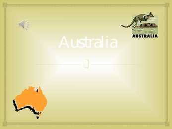
.................10 Conclusion....................................................................................................................11 Materials........................................................................................................................11 2 Australia Introduction Australia is the one and only country in the world which fills the whole continent. The continent it fills is called Australia too. So, Australia is both a country and a continent. If you want to make clear that you are speaking about the country, you may call it the Commonwealth of Australia. It’s the official name of the country. Australia is the smallest continent, but one of the largest countries on Earth. It’s 6th largest country. Its area is about 7.6 million sq km. One third of it is occupied by deserts. It’s both
........................ Aborigines and first settlers.......................................................................................... Sports............................................................................................. .................................... Culture............................................................................................. .................................. Factfile Australia is the only country in the worlf that fills the whole continent. The continent is also called Australia, if you want to make clear that you are speaking about the country you may call it by its official name: Commonwealth of Australia. Australia is the smallest continent, but one of the largest countries in the world. Its area is about 7,6 million sq kilometers. Its population is about 20,0 million and most of the people live in bigger cities: Sydney (4.2 million), Melbourne (3.7 million), Brisbane (2 million) and in Canberra, Which is also
Australia Australia , officially the Commonwealth of Australia, is a country in the Southern Hemisphere comprising the mainland of the Australian continent, the island of Tasmania and numerous smaller islands in the Indian and Pacific Oceans. Australia flag Australia coat of arms. Australia is a cloudless dark blue sky, the bright sun, multikilometer beaches with snowwhite sand and ocean up to horizon. Australia's landmass of 7,617,930 square kilometers is on the IndoAustralian Plate
Topic Australia Tallinn English College 2006 Australia 1 . Introduction The name Australia is derived from the Latin Australis, meaning of the south. In land area, Australia is the sixth largest nation, its territory is 7,686,850 sq km and its population reaches today over 20,5 million people. It is the only nation to govern an entire continent and its outlying islands. Australia's capital is Canberra, the only city with its own territory. It was built in the early 1900s just to be the capital. The official language is English and the official name of Australia is the Commonwealth of Australia. Australia is located on the Southern Hemisphere (because of that Australia is also called "A land down under"). 2 . Geographical position
Topic Australia Introduction Many people know Australia as the land down under because it is the only continent except for Antarctica that is all on the southern hemisphere. Its name means ,,Southland". The official name of the country is the Commonwealth of Australia. It's capital is Canberra. Australia is the sixth largest country in the world but the smallest continent. Australia has 6 states and 2 territories (New South Wales, Victoria, Tasmania, Queensland, Western Australia , South Australia, The Australian Capital Territory and the Northern Territory). The Australian people are culturally the same as the Anglo Americans. There also live aborigines. Aborigines are the ancestors of the people. Like the US and Canada, Australia was an English speaking colony of Great Britain. Today Australia is a modern developed country with a diversified economy. Australia is an island continent of 7.7 million square kilometres, which makes it a little smaller than the USA.
Australia Fact file: Australia comprises a land area of 7 686 850 square kilometres. Its population is about 21,3 million people. Australia's capital is Canberra. The national language is English. The official name of it is the Commonwealth of Australia. It's divided into six states and two territories: New South Wales, Queensland, South Australia, Western Australia, Tasmania, Victoria, Australian Capital Territory (ACT) and Northern Territory. Symbols: Australia had the British flag as their official flag until 1901, when the Commonwealth of Australia was formed. Over 30 000 entries attracted the official competition. Five of them, which contained almost identical designs, were placed equally first. The Australian flag symbolises Australia's historical links with Britain, because it has
Australia Australia is the smallest continent in the world. It is 7.6 million square kilometres big. It is often called the island continent because it is rather small for a continent and very big for an island. There are only five countries bigger than Australia in the World. There are five states in the mainland. Tasmania is also considered as a state so there are six states. The Northern Territory and Canberra are also independent but they are not states. Canberra is the capital of Australia and it is situated between Sydney and Melbourne because both of these cities wanted to be the capital.
CANADA Geography Canada is the world's second largest country in total area after Russia , since it covers nearly 10 million square kilometres, but is one of the most sparsely populated, with only about 34 million inhabitants. The majority of them live within 300 kilometres of Canada's southern border. Much of the rest of Canada is uninhabited or thinly populated, because the country has a rugged terrain and severe climate. Canada extends across the continent of North America, from Newfoundland on the Atlantic coast to British Columbia on the Pacific coast and northward into the Arctic Ocean. Canada shares land borders with the United States to the south and north-west. Canada is a land of great variety. Towering mountains, crystal-clear lakes, and lush, green
................. 11 3 Introduction The United States of America is an enormous country. It is the third largest in the world after Russia and Canada. In the USA there are 50 states of which 48 lie together. The population of The USA is about 300 million people. The territory is about 10 million square kilometers. Its geography is very diverse ranging from moist rainforests to dry deserts and bald mountain peaks. There are two big mountain ranges, one of them is the Rocky Mountains and the other is The Appalachian Mountains. The Capital of The USA is Washington D.C. Other big and famous cities are New York, Los Angeles, Houston, Chicago and Las Vegas. The national anthem of the United States is "The Star-Spangled Banner", with lyrics written in 1814 by Francis Scott Key. There are 6 time zones. From east to west they are: Eastern Standard Time, which is 5
MIINA HÄRMA GYMNASIUM Deserts Saudi-Arabia Tartu 2007 Deserts In geography, a desert is a landscape form or region that receives very little precipitation. Generally, deserts are defined as areas that receive an average annual precipitation of less than 250 mm (10 inches). Deserts cover at least one-fourth of the Earth's land surface. Desert biomes can be classified according to several characteristics. There are four major types of deserts: · Hot and dry · Semiarid · Coastal · Cold Location The four major North American deserts of hot and dry deserts are the Chihuahuan, Sonoran, Mojave and Great Basin. Others outside the U.S
AUSTRALIA Tallinn 2008 Only one country in the world fills a whole continent. That country is Australia. The continent it fills is Australia, too. Australia, then, is both a country and a continent. Australia is one only continent except Antartctica that is all south of the equator. Since it is south of the equator, its seasons are just the opposite of ours. It has summer while we have winter, and the other way round. Sometimes Australia is called the island continent. There is a good reason why. It is an island. It is 1800 miles from the mainland of Asia and almost half way round the world from Europe. More than 6000 miles of ocean separate it from the America. Australia is the world's smallest, flattest and driest continent. It is also the oldest some of the rocks are more than 3,000 million years old. It is the 6th largest country. Its territory is 7 700 000 km2.
1.Alaska info...................................3.lk 2.Geography.....................................4.lk 3.Natural features......................5.lk 4.Climate...........................................6.lk 5.Pictures.........................................7.lk 6.Used Sources..............................8.lk Alaska info Alaska is the largest state in the United States by area. It is situated in the northwest extremity of the North American continent, with Canada to the east, the Arctic Ocean to the north, and the Pacific Ocean to the west and south, with Russia further west across the Bering Strait. Alaska is the least densely populated state of the U.S. 2 Alaska was purchased from Russia on March 30, 1867, for $7.2 million at approximately two cents per acre. The land went through several administrative changes before becoming an organized territory on May 11, 1912, and the 49th state of the U.S. on January 3, 1959.
and it is bordered by three oceans: the Arctic, the Pacific and the Atlantic Oceans. The population of Canada is about 31 million people. About 77% of the people live in cities which lie in a band about 100 miles wide above the border of the United States. The capital of Canada is Ottawa. Other large cities are Montreal, Toronto, Vancouver, Winnipeg and Quebec. 2. Geographical position Canada is a huge country in the continent of North America. It is bordered with the Atlantic Ocean in the east, the Pacific Ocean in the west, the United States of America in the south and the Arctic Ocean in the north. Canada is a vast country, with a territory of 3.8 million square miles of land and fresh water it is the second biggest country in the world after Russia. Canada covers most of the northern part of North America. Canada has over 151,480 miles of coastline
Geography The name Australia means ,,southland". It is both a country and a continent, with an area of 7,617,930 square kilometres and it is also an island, separated from Asia by the Arafura and Timor seas. But Australia is also surrounded by the Indian and Pacific oceans. The Great Barrier Reef is the world's largest coral reef. It lies off the north-eastern coast and extends for over 2000 kilometres. The famous mountain range in the eastern part of Australia is the Great Diving Range and it's highest peak is Mount Kasciusco's 2230m. In the continental part, there are the Macdonnell ranges. Other smaller mountain ranges are the Musgrave Mountains, the Hammessley Mountains and the Darling Mountains. The continental part of Australia is mostly covered with deserts and these deserts are the Great Sandy Desert in the north-western part, the Great Victoria dessert in the southern part and Gibson desert and the
Outdoor sports like skiing, hiking, riding, swimming, boating, rafting, tennis, golf and fishing are encouraged across Canada. A half- or full-day fishing trip with a guide, which end up with cooking a meal from the catch, has recently become popular. In one word Canada is a vast country with many diversities and tourist attractions. With its spectacular nature Canada is wonderful. Location. Canada is a huge country in the continent of North America. It is bordered with the Atlantic Ocean in the east, the Pacific Ocean in the west, the United States of America in the south and the Arctic Ocean in the north. Canada is a vast country, with a territory of 3.8 million square miles of land and fresh water it is the second biggest country in the world after Russia. Canada covers most of the northern part of North America. Canada has over 151,480 miles of coastline. Most of Canada's human population lives
Introduction, Location Australia is a country between the Indian Ocean and the Pacific Ocean. It is the only country in the world that occupies an entire continent. The mainland covers an area of 7.7 million km² and it is about 3700 km from the most northern point to its most southern point and about 4000 km from east to west. There are also many different seas around Australia, like the Coral and the Tasman Seas in the west or the Timor and the Arafura Seas in the north, where the Indian and the Pacific Oceans meet. Because all seas and oceans near Australia are warm, surfing is a very popular hobby. Political subdivision Australia is divided into six states, which are: · New South Wales · Victoria · Queensland · South Australia · Western Australia
Arizona Arizona is a state in the southwestern region of the United States. It is also part of the Western United States and of the Mountain West states. It is the sixth largest and the 14th most populous of the 50 states. Its capital and largest city is Phoenix. Arizona is one of the Four Corners states. It borders with New Mexiko, Utah, Nevada, California, and Mexico, and one point in common with the southwestern corner of Colorado. Climate Southern Arizona is known for its desert climate, with very hot summers and mild winters. Northern Arizonafeatures forests of pine, Douglas fir, and
Each of them has their own capital city. Glasgow in Scotland, Cardiff in Wales and London in England. The country is situated in the north-western Europe. The territory of the United Kingdom is about 244,000 square kilometres and about 60 million people live there. The UK contains a number of small islands. The largest islands that belong to the United Kingdom are the Isle of Man in the Irish Sea and the Isle of Wight which lies off of England's southern coast. The largest groups of islands are the Shetland Islands, the Orkney Islands and the Hebrides. Geographical Position The UK is situated in the Northern Hemisphere. The United Kingdom is bordered by the Atlantic Ocean in the west, the North Sea in the east, the Norwegian Sea in the north, and the English Channel, also known as La Manche, in the south and it also separates the country from the continent of Europe. The neighbours of the United Kingdom are Iceland in the north-west,
Australia Australia is the only country in the world that covers an entire continent, yet also the smallest and the driest of all the continents. It's almost the same size as continental USA, being the sixth largest country in the world. It's also the oldest some of the rocks are more than 3,000 million years old. Australia is often called `Down Under', because it lies in the Southern Hemisphere. As a result, its seasons are the opposite of ours. Australia, Tasmania and a number of smaller islands form the Commonwealth of Australia. Because of the country's great size, the climate in Australia ranges from tropical regions of the Northern Territory to the cool temperate conditions in the southeast and Tasmania, where it often snows in winter. In the north, half the year is `wet' and half is `dry'. From November to April heavy rain fills
Malestrom Major Rivers N am e Continent Out fl o w T o tal Lengt h (mi.) Nile Africa Mediterran ean Sea 4,1 60 Am azo n South Am erica Atlantic Oce an 4,000 Ch ang (Yangtze) Asia East China Sea 3,964 M ississippi-M iss o u ri N o rt h Am eri ca Gul f of Mexico 3,710 Major Deserts
2010 Canada, Kärt Kalvet 8a Canada General Information Canada is in North America. It's area is 9220970 sq km. Canada's population is 313.612.000 people. Canada is divided into 10 provinces and 3 territories. The capital of Canada is Ottawa. Canada has constitutional monarchy. The head of state in Canada's government is the Queen of England. There are two main languages in Canada: English and French. Canada's curreny is Canadian dollar (1 dollar=100 cents[Can$]). The highest peak of Canada is Mount Logan, 5959 metres. The lowest point is sea level. The longest river is the Mackenzie. The climate and geography of Canada vary greatly from temperate in the south to arctic in the north and from islands and plains in the east to mountains in the west. Location Canada is located in the northern-most region of North America. It's geographical position in co- ordinates is 83°N north, 42°N south, 53°W east, 141°W west. Canada borders with United States
Australia Australia is a country and also a continent. If someone wants to make clear, that he is speaking of the country, he may call it by its full name of Commonwealth of Australia. Australia's name means "southland."It is south of the equator. Sometimes it is also called the island continent because it is an island. There are about twenty million people in Australia.It is 1,800 miles from the mainland of Asia and almost half way round the world from Europe. More than 600 miles of ocean separate it from Americas. Since Australia is south of the equator, its seasons are just the opposite of ours. It has summer while we have winter, and the other way round. States and Territories. Australia consists of six states, two territories and eight external territories.
Project ESTONIA MAP OF ESTONIA Southern Viljandimaa The southern part of Viljandi county catches the eye with its sublime scenery. The area today lies in the very heart of the historical Mulgimaa the home of hills, deep valleys and lakes brought together by a beauty spot Halliste primeval valley. According to several folk tales, it is also in these valleys, woods and bogs that Old Nick found refuge.The great variety displayed in the nature is also reflected in the local cultural heritage
Capital: Tallinn Language: Estonian Currency: Eesti kroon (EEK) Main religion: Lutheran National holiday: 24 February (anniversary of the republic) National flower: Cornflower National bird: Barn Swallow National stone: Limestone LOCATION The Republic of Estonia is the northernmost and smallest of the three Baltic States. It is located on the eastern shores of the Baltic Sea in the north east of Europe. To the east the country borders Russia. Latvia is the countries neighbour to the south. From the west the coast of Estonia is washed by the Baltic Sea and from the north by the Gulf of Finland. The length of the coastline is approximately 3 800 km. The longest distance from east to west is 350 km, while north to south Estonia stretches 240 km. THE NAME The name EESTI was apparently derived from the word AISTI, the name given by ancient Germans to the peoples living northeast of the Vistula River
NEW ZEALAND Geography: New Zealand is situated midway between the Equator and the South pole in the southern Pacific Ocean. It consists of two large islands, North Island and South Island, plus several smaller ones of which Stewart Island is the largest. North and South Islands are separated by the 32km wide Cook Strait. The total land area is 270,535 sq Km, about the size of Italy, the United Kingdom or the US state of Colorado. North Island is volcanically active with three active volcanoes. South Island has the high snow covered mountain peaks and glaciers of the Southern Alps, a range running almost 500Km along the Island. The longest river is the Waikato on North Island (425 Km), the largest inland stretch of water is Lake
The capital city is Washington D.C. Although the United States has no official language at the federal level, English is the de facto national language. English is the most common language for daily interaction among both native and non-native speakers. Spanish is the second language. The largest city is the New York City. The Government is Federal constitutional republic and the president is George W. Bush. 2. Geographical position The United States of America is located on the continent of North America. It has borders with two countries Mexico and Canada. There are also the Atlantic Ocean, the Pacific Ocean and the Gulf of Mexico surrounding the big country. There are 50 states in America. Most of the people live in towns. The biggest state is Alaska; next by size are California, Alaska and Montana. Six states - Maine, Vermont, New Hampshire, Connecticut, Rhode Island and Massachusetts are called New England. They are all small states in the USA that lie in the north- east
The United States of America Geography The United States of America is situated in the central part of the North American continent. Its western coast is washed by the Pacific Ocean, and its eastern coast by the Atlantic Ocean and the Gulf of Mexico. It borders on Canada in the north and on Mexico in the South. The U.S.A. consists of 51 states and the District of Columbia. The state of Alaska is separated from the rest of the U.S.A. by Canada. Hawaii, which became the fiftieth state in 1959, is in the Pacific Ocean, halfway between the continents of America and Asia. The area of the United States of America is over nine million square kilometres. The continental part of the U.S.A. consists of two highland regions and two lowland regions. The
The population of the island is just under 6 million (2006); just over 4.2 million in the Republic of Ireland[2] (1.6 million in Greater Dublin[3]) and just over 1.7 million in Northern Ireland[4] (0.6 million in Greater Belfast[5])). Politics Politically, Ireland is divided into: · The Republic of Ireland, with its capital Dublin. · Northern Ireland, which is part of the United Kingdom, Geography A ring of coastal mountains surrounds low central plains. The highest peak is Carrauntuohill , which is 1,041 m. The island is bisected by the River Shannon, at 386 km (240 miles) the longest river in Ireland. The island's lush vegetation, a product of its mild climate and frequent but soft rainfall, earns it the sobriquet "Emerald Isle". The island's area is 84,412 km². Ireland is divided into four provinces: Connacht, Leinster, Munster and Ulster. Ireland's least arable land lies in the south-western and western counties. These areas are largely
Scotland ! Scotland (Gaelic: Alba) is a country in northwest Europe that occupies the northern third of the island of Great Britain. It is part of the United Kingdom, and shares a land border to the south with England. It is bounded by the North Sea to the east, the Atlantic Ocean to the north and west, and the North Channel and Irish Sea to the southwest. In addition to the mainland, Scotland consists of over 790 islands including the Northern Isles and the Hebrides. Edinburgh, the country's capital and second largest city, is one of Europe's largest financial centres. It was the hub of the Scottish Enlightenment of the 18th century, which saw Scotland become one of the commercial,
The United States of America (The U.S.A) Geography The main part of the United states extends from the Atlantic Ocean in the east to the Pacific Ocean in the west. It covers the middle of the North American continent. This area is called ,,the continental United states". The continental United States is bounded to the North by Canada and to the South by Mexico. The border with Canada is often called ,,the longest unguarded border in the world". The United States and Canada are good friends and they have very few problems in managing the border. The borded with Mexico is different. Immigrants are constantly crossing the border illegally. Every day about 2,000 of them are captured and sent back, but may others get through. There are also two states that are not connected to the continental United States. They are Alaska and Hawaii.
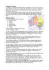
IMPORTANT ABOUT CZECH REPUBLIC AND PRAGUE Czech Republic Ceská republika (Czech) Flag Coat of arms Motto: "Pravda vítzí" (Czech) "Truth prevails" Anthem: Kde domov mj? (Czech) "Where is my home?" 5 Figure2. European map. Location of Czech Republic (green) - on the European continent (light green & grey) - in the European Union (light green). Capital (and largest city) Prague (Praha). Official language(s) Czech, Slovak. Government Parliamentary republic. President Václav Klaus. Prime Minister Jan Fischer. EU accession 1 May 2004. Total area- 78,866 km2 (116th). 30,450 sq mi. Water 2%. Population 2009 estimate 10,506,813 (78th)- 2001 census 10,230,060. Density- 132/km2 (77th). 341/sq mi. Calling code +420. HISTORY The recent past
New Zealand's smallest national park. One of New Zealand's sunniest spots. The beaches have a range of coloured sand from gold to white that look out onto the clear waters of the Tasman Sea. Top ten places to visit in New Zealand Queenstown Beautiful lake side town is surrounded by mountains and is one of New Zealands premier tourist destinations. The home of bungee jumping and jet boating. Queenstown is also one of the southern hemispheres premier skiing destinations Rotorua Famous for its volcanic activity. Every reserve has spectacular examples of geysers, boiling pools, hot springs, boiling mud, volcanic terraces, and craters. Mt Tarawera nearby volcano offers spectacular scenery including superb views inside the rim of the volcano Best area in the country to experience and learn about Maori Culture. Top ten places to visit in New Zealand Bay of Islands