Leidsid 33 sarnast õppematerjali, mis on seotud failiga "Suurbritannia ja USA geograafia". Need materjalid aitavad sul teemat sügavamalt mõista.
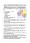
land, here, south, mountain, there, scotland, england, mountains, north, wales, region, southern, highland, lowland, west, highest, nevis, coverart, mostly, rollinglain, coal, rise, raise, sheep, fishing, deposit, areas, district, describe, scottish, northern, country, gently, best, hills, living, mild, important, china, moor, five, britain, include........... 8 Population and Ethnicity..............................................................................................9 3 Introduction The official name of the country is the United Kingdom. The United Kingdom is an island country. It consists of the island of Great Britain and Northern Ireland. Great Britain can be divided into three parts England, Wales and Scotland. Each of them has their own capital city. Glasgow in Scotland, Cardiff in Wales and London in England. The country is situated in the north-western Europe. The territory of the United Kingdom is about 244,000 square kilometres and about 60 million people live there. The UK contains a number of small islands. The largest islands that belong to the United Kingdom are the Isle of Man in the Irish Sea and the Isle of Wight which lies off of England's southern coast
Report of SCOTLAND Maiki Joakit 10. klass 2008 Etymology Scotland is from the Latin Scoti, the term applied to Gaels. The Late Latin word Scotia (land of the Gaels) was initially used to refer to Ireland. By the 11th century at the latest, Scotia was being used to refer to (Gaelic-speaking) Scotland north of the river Forth, alongside Albania or Albany, both derived from the Gaelic Alba. The use of the words Scots and Scotland to encompass all of what is now Scotland became common in the Late Middle Ages. History Repeated glaciations, which covered the entire land-mass of modern Scotland, have destroyed any traces of human habitation that may have existed before the Mesolithic period. It is believed that the first post-glacial groups of hunter-gatherers arrived in Scotland around 12,800 years ago, as the ice sheet retreated after the last glaciation. Groups of settlers began building the first known permanent houses on Scottish soil around 9,500
The United Kingdom The United Kingdom consists of England, Scotland, Wales and North Ireland and it is situated in the Atlantic Ocean near the mainland of Europe. The population of the UK is 58.6 million and area is 244,110 sq km. Britain has a temperate humid climate. Its characteristic features are mild winters, warm summer, no temperature extremes, abundant rain all year round and frequent changes of weather. The mild climate is partly due to the warm Gulf Stream and partly to the south westerly winds. Occasional winds from the east in winter may
Tallinn English College Topic Great Britain 2007 1. Introduction The official name of Great Britain is `the United Kingdom of Great Britain and Northern Ireland (or short United Kingdom)' The population is about 60.4 million. The capital is London. Other biggest cities include Birmingham, Bristol, Portsmouth, Glasgow and Swansea. English is the main language of Great Britain, but Welsh is officially recognized in Wales and Gaelic in Scotland. 2. Geographical position The British Isles is the geographical term for a group of about 5000 islands off the coast of mainland Europe. The largest island is Great Britain, which is also the largest island in Europe. It consists of England, Wales and Scotland. The next largest island is Ireland, which is made up of Northern Ireland and the Irish Republic. Britain and Northern Island together form the United Kingdom. When referring to Britain or Great
Scotland ! Scotland (Gaelic: Alba) is a country in northwest Europe that occupies the northern third of the island of Great Britain. It is part of the United Kingdom, and shares a land border to the south with England. It is bounded by the North Sea to the east, the Atlantic Ocean to the north and west, and the North Channel and Irish Sea to the southwest. In addition to the mainland, Scotland consists of over 790 islands including the Northern Isles and the Hebrides. Edinburgh, the country's capital and second largest city, is one of Europe's largest financial centres. It was the hub of the Scottish Enlightenment of the 18th century, which saw Scotland become one of the commercial, intellectual and industrial powerhouses of Europe. Scotland's largest city is Glasgow, which was once one of the
'ledsltv 'sembl/ seadusandlik kogu The British Isles is the name of a group of islands washed by the North Sea in the east and the Atlantic Ocean in the west. The British Isles are shared by two separate and independent countries: the
ENGLAND General overview England is part of the United Kingdom Land borders with Scotland to the north and Wales on to the west The English Channel on south separates it form continental Europe The country includes over 100 smaller islands Capital and largest city is London Its has consitutional monarchy Monarch is Elizabeth II Total area is 130,395 km2 Population is 51,446,000 million, around 84% of the population of the UK Currency is Pound stearling(GBP) Has left-hand traffic Patron saint is ST. George Geography England comprises the central and southern two-thirds of the island of Great
Geography Canada is the world's second largest country in total area after Russia , since it covers nearly 10 million square kilometres, but is one of the most sparsely populated, with only about 34 million inhabitants. The majority of them live within 300 kilometres of Canada's southern border. Much of the rest of Canada is uninhabited or thinly populated, because the country has a rugged terrain and severe climate. Canada extends across the continent of North America, from Newfoundland on the Atlantic coast to British Columbia on the Pacific coast and northward into the Arctic Ocean. Canada shares land borders with the United States to the south and north-west. Canada is a land of great variety. Towering mountains, crystal-clear lakes, and lush, green forests make Canada's far west a beautiful region. Farther inland, fields of wheat and other grains cover Canada's vast prairies
Oceans. The population of Canada is about 31 million people. About 77% of the people live in cities which lie in a band about 100 miles wide above the border of the United States. The capital of Canada is Ottawa. Other large cities are Montreal, Toronto, Vancouver, Winnipeg and Quebec. Canada has two official languages English and French. It's interesting to know that about 61% of Canadians name English and 24% French their mother tongue. There are also many other languages spoken in Canada such as: Italian, Chinese, German, Polish, Ukrainian, Greek and Dutch. There are also many native languages such as Algonquian. The British and the French as the main settlers from Europe fought for hundreds of years before they managed to build up a country which was based on recognizing the cultural diversity of different nations in Canada. All the communities living in the
1) General facts The UK: * the United Kingdom of Great Britain and Northern Ireland was formed in 1801 * it covers 243,610 sq km * everybody from the UK is called British * the capital city is London * is made up of four constituent countries: England, Scotland, Wales and Northern Ireland which in turn are divided into counties * the flag is called the Union Jack which is a combination of the flags of England, Scotland and Northern Ireland * the population is about 60,000,000 people, the population density is 242 people/sq km * its coasts are washed by the Atlantic Ocean, the North Sea, the English Channel, the Celtic Sea, Saint George's Channel, and the Irish Sea. It is linked to France by the Channel Tunnel * the United Kingdom is a constitutional monarchy. The current monarch is Queen Elizabeth II, who is also the Queen and Head of State of fifteen other Commonwealth Realms, such as
Geography and climate/weather When I think about the UK I think about London and its sights. the second thing that pops into my mind the weather and how they talk and complain that the weather is bad and it is raining, The weather in the UK is actually changeable and it doesn't rain all the time They are in the Temperate climate zone and the Gulf stream affect their weather. so there are no extreme weather conditions Much of the land in England is low lying. forming meadows and pastures Upland areas are generally confined to northern England The Pennines are a range of mountains and hills in Northern England The Midlands' largest city is Burmingan.. It is one of England’s principal industrial and commercial areas. The highest point of the UK is Ben Nevis which is located in Scotland and the longest river in the UK is the Severn which begins in Wales. Scotland and Wales are the most mountainous parts of the UK
................................8 Culture..........................................................................................................................9 Materials.................................................................................................................... 11 3 Introduction The United States of America is an enormous country. It is the third largest in the world after Russia and Canada. In the USA there are 50 states of which 48 lie together. The population of The USA is about 300 million people. The territory is about 10 million square kilometers. Its geography is very diverse ranging from moist rainforests to dry deserts and bald mountain peaks. There are two big mountain ranges, one of them is the Rocky Mountains and the other is The Appalachian Mountains. The Capital of The USA is Washington D.C. Other big and famous cities are New York, Los Angeles, Houston, Chicago and Las Vegas.
Australia Fact file: Australia comprises a land area of 7 686 850 square kilometres. Its population is about 21,3 million people. Australia's capital is Canberra. The national language is English. The official name of it is the Commonwealth of Australia. It's divided into six states and two territories: New South Wales, Queensland, South Australia, Western Australia, Tasmania, Victoria, Australian Capital Territory (ACT) and Northern Territory. Symbols: Australia had the British flag as their official flag until 1901, when the Commonwealth of Australia was formed. Over 30 000 entries attracted the official competition. Five of them, which contained almost identical designs, were placed equally first. The Australian flag symbolises Australia's historical links with Britain, because it has
Tallinn English College Report of Canada 8a Teacher: Merike Sisask Composer: Kärt Kalvet 2010 Canada, Kärt Kalvet 8a Canada General Information Canada is in North America. It's area is 9220970 sq km. Canada's population is 313.612.000 people. Canada is divided into 10 provinces and 3 territories. The capital of Canada is Ottawa. Canada has constitutional monarchy. The head of state in Canada's government is the Queen of England. There are two main languages in Canada: English and French. Canada's curreny is Canadian dollar (1 dollar=100 cents[Can$]). The highest peak of Canada is Mount Logan, 5959 metres. The lowest point is sea level
Geography The name Australia means ,,southland". It is both a country and a continent, with an area of 7,617,930 square kilometres and it is also an island, separated from Asia by the Arafura and Timor seas. But Australia is also surrounded by the Indian and Pacific oceans. The Great Barrier Reef is the world's largest coral reef. It lies off the north-eastern coast and extends for over 2000 kilometres. The famous mountain range in the eastern part of Australia is the Great Diving Range and it's highest peak is Mount Kasciusco's 2230m. In the continental part, there are the Macdonnell ranges. Other smaller mountain ranges are the Musgrave Mountains, the Hammessley Mountains and the Darling Mountains. The continental part of Australia is mostly covered with deserts and these deserts are the Great Sandy Desert in the north-western part, the Great Victoria dessert in the southern part and Gibson desert and the
Canada. Canada is a very big country in the continent of North America. It is about 10 million square kilometres and that makes it the second largest country in the world after Russia. Quebec (the province) is six times as big as the UK. Canada borders the Atlantic Ocean, the Pacific Ocean, the Arctic Ocean and the USA. The capital of Canada is Ottawa and other main cities are Toronto, Montreal and Vancouver. It is a very developed country. Montreal is the largest city and it is called the Paris of North America because most of the people there speak French
Australia Australia is the smallest continent in the world. It is 7.6 million square kilometres big. It is often called the island continent because it is rather small for a continent and very big for an island. There are only five countries bigger than Australia in the World. There are five states in the mainland. Tasmania is also considered as a state so there are six states. The Northern Territory and Canberra are also independent but they are not states. Canberra is the capital of Australia and it is situated between Sydney and Melbourne because both of these cities wanted to be the capital. The population is about 19 million people and growing. New South Wales is the most populated state and Victoria is the most densely populated state. The national language is English. It is English because British settlers came to live in Australia in
The United Kingdom and London United Kingdom is a political name of the United Kingdom of Great Britain and Northern Ireland. These political names include the countries of England, Scotland and Wales. Every country has its own capital and language. The capital of England is London, the people there are english and the language spoken is English. In scotland live the scots, capital is Edingburg and the languages spoken are English and Scottish. The capital of Wales is Cardiff, the people tehre are welsh and the languages spoken are welsh and English. N. Ireland is the home for the Irish, the capital is Belfast and the language is Irish. The first inhabitants were Iberians and Celts who settled on the land and were often at war with each other. In AD 43 Britain was made a Roman province. The romans stayed there for three hundred years
1. What are the capitals of the 4 constituent countries? England- London; Northen Ireland- Belfast; Scotland- Edinburgh; Wales- Cardiff 2. Order the invaders in correct chronological order: Anglo-Saxons, Normans, Romans, Celts. Romans Anglusaxons , Norman 3. How did the Celts influence Britain? Language. Wars. Engand and Scotland eventually became 1 contry 4. How many people approximately speak English? Approximately 600 million 5. Who (which tribes) gave the base of the English language?Germanic tribes- Anglo-Saxons. 6. Describe Wales.- Wales is a mountainous country on the western side of Great Britain. The national game of Wales is Rugby. Flag- Red dragon on a green and white field. They have their own language Cymraeg ( Welsh) . Anthem- Land Of My Fathers
CANADA Canada is a vast country, second largest country of the world after Russia. It stretches from the Atlantic Ocean in the east to the Pacific Ocean in the west and to the Arctic Ocean in the North. Canada Covers most of the northern part of North America and its geography is very diverse. Canada's area is about 10 million square kilometers and its population is 31 000 000. Its capital is Ottowa and other main cities are Toronto, Montreal and Vancouver. Almost 75 % of canadians lives within 300 kilometer of the USA border, because the climate is softer in the South. 89 % of Canada is almost unhabited. Its official languages are English and French, but many other languages are spoken too
and it is bordered by three oceans: the Arctic, the Pacific and the Atlantic Oceans. The population of Canada is about 31 million people. About 77% of the people live in cities which lie in a band about 100 miles wide above the border of the United States. The capital of Canada is Ottawa. Other large cities are Montreal, Toronto, Vancouver, Winnipeg and Quebec. 2. Geographical position Canada is a huge country in the continent of North America. It is bordered with the Atlantic Ocean in the east, the Pacific Ocean in the west, the United States of America in the south and the Arctic Ocean in the north. Canada is a vast country, with a territory of 3.8 million square miles of land and fresh water it is the second biggest country in the world after Russia. Canada covers most of the northern part of North America. Canada has over 151,480 miles of coastline
Alberta The capital of Alberta is Edmonton. The population is 3.7 million people and there are many nationalities. Besides English and French there are also immigrants from Scotland, Ireland, Wales, Germany, Ukraine and Scandinavia. In Edmonton and Calgary there are also historic Chinatowns, and Calgary has Canada's third largest Chinese community. Geographical features Alberta covers an area of 661,848 square kilometres, an area about 5% smaller than Texas or 20% larger than France. This makes it the fourth largest province after Quebec, Ontario, and British Columbia. To the south, the province borders on the 49th parallel north, separating it from the U.S. state of Montana, while on the north the 60th parallel north divides it from the
The UK & London The United Kingdom (or the UK) is a short way of saying the United Kingdom of Great Britain and Norther Ireland. The UK is situated north-west of the European continent between the Atlantic Ocean and the North Sea. The UK consists of England, Wales, Scotland and Northern Ireland. Its highest point is Ben Nevis in Scotland followed by Snowdon in Wales. The Severn is the longest river in the United Kingdom. Other important rivers are the Trent, the Mersey, the Tyne, etc. Lough Neagh which lies in the centre of Northern Ireland is thr UK's largest freshwater lake. The climate in the UK is variable. The weather changes so frequently that it is difficult to forecast. It is not unusual for people to complain that the weathermen were wrong. Fortunately there is no extreme weather conditions, it is never very cold or very hot.
Early History The first inhabitants of Canada were native Indian people who were called as Inuits. They are believed to be in Canada since about 10000 BC. The Inuits came to Canada from Asia crossing the Bering land bridge. The earliest discoveries in Canada were made by the Vikings. In AD 985 Vikings sailing from Iceland to Greenland were blown westward off their course and the Vikings sighted the coast of Labrador peninsula. The report of forested areas encouraged further exploration because the colonies in Greenland which belonged to the Vikings lacked lumber. In AD 1000 Leif Ericson became the first European to land in North America.
Introduction, Location Australia is a country between the Indian Ocean and the Pacific Ocean. It is the only country in the world that occupies an entire continent. The mainland covers an area of 7.7 million km² and it is about 3700 km from the most northern point to its most southern point and about 4000 km from east to west. There are also many different seas around Australia, like the Coral and the Tasman Seas in the west or the Timor and the Arafura Seas in the north, where the Indian and the Pacific Oceans meet. Because all seas and oceans near Australia are warm, surfing is a very popular hobby. Political subdivision Australia is divided into six states, which are: · New South Wales · Victoria · Queensland · South Australia · Western Australia · Tasmania New South Wales is the most populous state in Australia. Its capital is Sydney. Victoria is one of the most densely populated states in Australia. Its capital city is Melbourne
% (mid- Part Population (mid-2006) 2006) England 50,762,900 83.8 Scotland 5,116,900 8.4 Wales 2,965,900 4.9 Northern Ireland 1,741,600 2.9 United Kingdom 60,587,300 100 Although Britain is quite small in terms of land area (245,000 sq km), it has a large population of nearly 61 million, which ranks the 21st in the world (Britain is the 21st most populous state in the world) and the third largest in the European Union. The size of population is changing very slowly. Natural change is the difference between birth and death rates. It may be a natural increase or a natural decrease. Birth rate the number of babies born per 1,000 persons per year 12
Labour Party, the Liberal Party and National Party. The Senat's membership is wider, it comprises 12 senators from each state and 2 from each territory. Senators are elected for six year terms. The Executive power in Australia is in the hands of the Commonwealth Government lead by the Prime Minister. Today the Prime Minister is John Howard, the leader of the Liberal Party. History Australia was once a part of the giant continent Gondwana. It included Africa, South America and Antarctica. First Australia and Antarctica split from Gondwana, then Australia broke away from Antarctica and began to move north. Aborigines arrived there about 50 000 years ago. They had occupied the whole continent by 30 000 years ago. At that time Tasmania was still part of the mainland. About 20 000 years ago the ice began to melt and the rising water level cut Tasmania off from the mainland. Traders from what is now Indonesia are thought to have been visiting
Topic Australia Tallinn English College 2006 Australia 1 . Introduction The name Australia is derived from the Latin Australis, meaning of the south. In land area, Australia is the sixth largest nation, its territory is 7,686,850 sq km and its population reaches today over 20,5 million people. It is the only nation to govern an entire continent and its outlying islands. Australia's capital is Canberra, the only city with its own territory. It was built in the early 1900s just to be the capital. The official language is English and the official name of Australia is the Commonwealth of Australia.
If you want to make clear that you are speaking about the country, you may call it the Commonwealth of Australia. It’s the official name of the country. Australia is the smallest continent, but one of the largest countries on Earth. It’s 6th largest country. Its area is about 7.6 million sq km. One third of it is occupied by deserts. It’s both the flattest and, except for Antarctica the driest. Neighbouring countries include Indonesia, East Timor and Papua New Guinea in the north, the Solomon Islands, Vanuatu in the northeast, and New Zealand in the southeast. Its capital is Canberra. Other big cities are Melbourne, Sydney, and Brisbane. National language in Australia is English. Monetary unit is Australian dollar. Their national holiday is on the 26th of January. In 1788 on the 26th of January the first fleet arrived at Botany Bay and established a penal colony near modern-day Sydney. Geographical Position Australia is located in the Southern Hemisphere. It’s the
Canada is the second largest country in the world. Situated to the north of the United States, in North America, it has both English and French as its official languages. Even though its area is bigger than that of the United States, its population is only about 11% of that of the USA some 35 million. Because of that, Canada has one of the lowest population densities in the world. The capital of Canada is Ottawa the name of whose comes from the old Algonquin language, with the original word meaning `to trade'.
NEW ZEALAND Geography: New Zealand is situated midway between the Equator and the South pole in the southern Pacific Ocean. It consists of two large islands, North Island and South Island, plus several smaller ones of which Stewart Island is the largest. North and South Islands are separated by the 32km wide Cook Strait. The total land area is 270,535 sq Km, about the size of Italy, the United Kingdom or the US state of Colorado. North Island is volcanically active with three active volcanoes. South Island has the high snow covered mountain peaks and glaciers of the Southern Alps, a range running almost 500Km along the Island. The longest river is the Waikato on North Island (425 Km), the largest inland stretch of water is Lake Taupo also on North Island (607 sq Km) and the highest point is Mount Cook on South Island (3754 m)
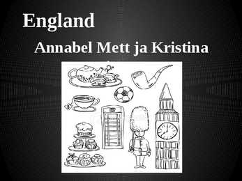
England Annabel Mett ja Kristina Smirnova 8.b Englands Geography · England is a part of the United Kingdom of Great Britain, its an island situated off the North West coast of Europe. · Bordered by Scotland in the north, the North Sea in the east, the England Channel in the south and Wales in the west. · Most of England is rolling hills. · Scafell Pike is the highest mountain in England with an elevation of 978 meters. Key Facts on England · Major Cities: London-Leeds-Liverpool-Manchester. · Capital: London with a population of 7,556,900. · Population: 51,446,000 inhabitants. · Geographic size: 130,395km². · National Anthem: None. God Save the Queen, Land of Hope and Glory. · Currency: Pound sterling (GBP). · Distribution: Males: 48,7% Females: 51,3% Climate of England · England has a temperate climate, with mild winters with temperatures not much lower than 0 C,
The capital city is Washington D.C. Although the United States has no official language at the federal level, English is the de facto national language. English is the most common language for daily interaction among both native and non-native speakers. Spanish is the second language. The largest city is the New York City. The Government is Federal constitutional republic and the president is George W. Bush. 2. Geographical position The United States of America is located on the continent of North America. It has borders with two countries Mexico and Canada. There are also the Atlantic Ocean, the Pacific Ocean and the Gulf of Mexico surrounding the big country. There are 50 states in America. Most of the people live in towns. The biggest state is Alaska; next by size are California, Alaska and Montana. Six states - Maine, Vermont, New Hampshire, Connecticut, Rhode Island and Massachusetts are called New England. They are all small states in the USA that lie in the north- east