found and the contrast with later Caledonian resistance is striking. Originals of On the Ocean do not survive, but copies are known to have existed in the first century AD so at the least a rudimentary knowledge of the geography of north Britain would have been available to Roman military intelligence. Pomponius Mela, the Roman geographer, recorded in his De Chorographia, written circa AD 43, that there were thirty Orkney islands and seven Haemodae (possibly Shetland). There is certainly evidence of an Orcadian connection with Rome prior to 60 AD from pottery found at the broch of Gurness. By the time of Pliny the Elder, who died in AD 79, Roman knowledge of the geography of Scotland had extended to the Hebudes (The Hebrides), Dumna (probably the Outer Hebrides), the Caledonian Forest and the Caledonii. Ptolemy, possibly drawing on earlier sources of information as well as more contemporary accounts from the
These institutions and the immigration of French and Anglo-French knights and churchmen facilitated a process of cultural osmosis, whereby the culture and language of the low-lying and coastal parts of the kingdom's original territory in the east became, like the newly acquired south-east, English-speaking, while the rest of the country retained the Gaelic language, apart from the Northern Isles of Orkney and Shetland, which remained under Norse rule until 1468. The Wallace Monument commemorates William Wallace, the 13th-century Scottish hero. The death of Alexander III in March 1286, followed by the death of his granddaughter Margaret, Maid of Norway, broke the succession line of Scotland's kings. This led to the intervention of Edward I of England, who manipulated this period of confusion to have himself recognised as feudal overlord of Scotland. Edward organised a process to identify the
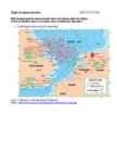
their own capital city. Glasgow in Scotland, Cardiff in Wales and London in England. The country is situated in the north-western Europe. The territory of the United Kingdom is about 244,000 square kilometres and about 60 million people live there. The UK contains a number of small islands. The largest islands that belong to the United Kingdom are the Isle of Man in the Irish Sea and the Isle of Wight which lies off of England's southern coast. The largest groups of islands are the Shetland Islands, the Orkney Islands and the Hebrides. Geographical Position The UK is situated in the Northern Hemisphere. The United Kingdom is bordered by the Atlantic Ocean in the west, the North Sea in the east, the Norwegian Sea in the north, and the English Channel, also known as La Manche, in the south and it also separates the country from the continent of Europe. The neighbours of the United Kingdom are Iceland in the north-west, Norway in the east and France in the south.
11.2011 2) CIA The World Factbook. Loetud: https://www.cia.gov/library/publications/the-world- factbook/geos/uk.html, 24.11.2011 3) Country Rankings 2011 Country comparisons, Economy, Geography, Climate, Natural Resources, Current Issues, International Agreements, Population, Social Statistics, Flags, Maps, Political System. Loetud: http://www.photius.com/rankings/index.html#ECONOMY, 21.11.2011 4) Islanders' carbon footprint among the biggest in Britain, says new study/Shetland Times.co.uk. Loetud: http://www.shetlandtimes.co.uk/2009/09/25/islanders-carbon-footprint-among-the- biggest-in-britain-says-new-study, 21.11.2011 5) Liiber, Ü., Rootsmaa, V., Saar, E., Uibo, M. (2007) Maailma ühiskonnageograafia gümnaasiumile. Töövihik. Eesti Loodusfoto 6) Major mineral fuel resources in Europe, Caucasus and Central Asia Maps and Graphics at UNEP/GRID Arendal. Loetud: http://maps.grida.no/go/graphic/major-mineral-fuel-resources-
peamiselt kauplemisega. 2)elukutselised maa pärandati vanemale pojale. 3) koonungid e. Kuningad maade juurde hankimiseks. Taani viikingid Frangi riigi jõgedeäärsed alad, 919 viiking Frollo sai endale Normandia, Astuuria ja Portugal(844a.) Baleaarid,Toskana, Inglismaal vallutasid suure osa saarest kuningas Alfred Suur 871-899a. Võitis küll Londoni tagasi, aga tunnistas viikingite võimu Ida-Inglismaal, kutsuti Danelag'ks. Norra viikingid nende suund oli põhja suunas, Shetland, Orkney, Island, Hibriidid ja Iirimaa.874- asustatakse Island, 982 Gröönima, Erik Punane, Leif Ericson Ameerika 1000a. Rootsi viikingid e. Variaagid, Ida-Euroopa jõgedel, 862. Kutsutakse Venemaad valitsema. Umbes tuhandedal aastal võtsid vastu ristiusu ja jäid paikseteks. Riikide tekkimine skandinaavias Taani Tekkis 960a. Harald Sinihammas võttis vastu ristiusu ja laiendas riiki Rootsi arvelt ja mingi ajal ühendas Norra
Omaette kõrgendikul linnused Valliga ümbritsetud nn ringvall-linnused Suhteliselt tasastel aladel, kaitserajatisteks kuhjati linnuseala ümber pinnasest vall, millel tõenäoliselt oli puust kaitserajatis. Tänapäeval vallid üsna madalad VIIKINGIAEG 800-1050 pKr Viikingite so Norra, Rootsi ja Taani aladel elavate skandinaavlaste mõju laienes: 1) Röövretked Briti saartele ja Lääne-Euroopasse 2) Saarte asustamine (Shetland, Fääri saared, Island, kolooniad Gröönimaal ja Põhja- Ameerikas 3) Kaubaretked Ida suunas Viikingiajal jäi kasutusele enamik varasemaid linnuseid, mida laiendati ja uuendati. Enamasti piirdus kaitserajatis puittaraga, pinnasevall vaid looduslikult raskesti kaitstavates osades Iseloomulik on, et linnuse kõrval on ka asulakoht. Linnustega seostub käsitöö Enamus viikingiajal kasutusel olnud linnused jäeti hilisrauajal maha Enamik külasid siiski linnustest eemal
Barrels from an area in which the crude oil's molecular characteristics have been determined and the oil has been classified are used as pricing references throughout the world. Some of the common reference crudes are: West Texas Intermediate (WTI), a very high-quality, sweet, light oil delivered at Cushing, Oklahoma for North American oil Brent Blend, comprising 15 oils from fields in the Brent and Ninian systems in the East Shetland Basin of the North Sea. The oil is landed at Sullom Voe terminal in Shetland. Oil production from Europe, Africa and Middle Eastern oil flowing West tends to be priced off this oil, which forms a benchmark Dubai-Oman, used as benchmark for Middle East sour crude oil flowing to the Asia- Pacific region Tapis (from Malaysia, used as a reference for light Far East oil) Minas (from Indonesia, used as a reference for heavy Far East oil)
A German spray for gooseberry mildew was, meanwhile, blacklisted. The 1915 Show was a sad affair, with steady rain, mud underfoot, and waterfalls from the tent roof. The railway companies had been quite incapable of delivering the essential rocks and plants on time for the Show, so exhibitors had found other ways to bring them to Chelsea. Lady Dundas, a charitable fund raiser for war victims, arranged for Viscount Dalrymple, then a small boy, to parade around the grounds on a Shetland pony to collect money for the war. The RHS, which in 1911 refused to allow ladies banquets, now recognized that lady gardeners existed, and acknowledged the necessity to dig for victory. In 1915 it even organized a show of women's work at the Horticultural Halls. As the war deepened, the RHS struggled on. By November the Council had removed King Ferdinand of Bulgaria as an honorary fellow and, the following February,
on the coast of the kingdom of the West Saxon. Many were sailors who sailed looking for plunder, trade and land for new settlements. Their craftworkers made beautiful objects. Most of the written evidence about the Vikings in England comes from ANGLO-SAXON CHRONICLE (892) Vikings lived in country settlements, grew crops, vegetables, kept animals, hunted animals, birds, fish. Vikings were great traders in town markets. JORVIK typical Viking town 9th c. V. moved to the islands of Shetland, Orkneys, the Hebrides, Ireland Sutton Hoo near Woodbridge, Suffolk, England, is the Anglo-Saxon burial place from the 6th century and early 7th century, which was found in 1939. The wooden ship, which was buried there, contained lots of armour, weapons, jewellery, symbols of power and other treasures, but no bodies were found. 10. Roman conquest In the 1st c. BC the Roman Empire began to make contact with Britain (wine, pottery, small bronze statues)
4. Universaalsed tõud rakkehobused, võib ka ratsutada. Tori universaalne tüüp(T) 5. Poolraskeveo hobused rootsi ardennid(Asw) , vene raskeveohobune, Eesti raskeveo hobune(ER- ardennist saadud ja NL pool tunnustamata) , postjee bretoon 6. Raskeveo hobuse Brabansooni tõug Belgiast. Klaidsteil. Suffolk. Nõukogude raskeveohobune, sair, perseron, vladimiri raskeveohobune(tsaari ajal kaevanduste jaoks) 7. Ponid kõik hobused kuni 148cm kõrgusega. Shetland, Walesi poni, Vastavalt tõuaretustööle nimetatakse tõugusid veel 1. Täisverelised märgitakse ainult need, kelle mõlemad vanemad on tõuraamatus sees. Inglise täisvereline, araabia täisvereline,angloaraab ja tulevikus trakeen, paaritada võib ainult tõupuhaste loomadega. 2. poolverelised need tõud, kus tõu loomise käigus 3-4 põlvkonna lisatakse täisvereliste verd. Hannover, holstein, vene ratsahobune. 08.03.11
Laevad on ksukil 21- 23m pikad, 4-5 m laiad. Üheteist kuni kuueteist paarini.aerud olid 6m pikad. Sihtpunktid Rootslased suundusid peamiselt venemaa aladele. Asustasid oluliste kaubapunktidega nokurodi ja kiievi. Musta mere kaudu kauplesid nad bütsantsiga. Taanlased mõjutasid rohkem lõunamaid. Uk prants frangi jne. Tõid inglise keelde sõnad take die anger hell ugly. Norralased hõivasid vähe tuntuid piirkondi. Jõudsid soti ja iirimaale. Shetland ja fääri saartele. Asustasid islandi ja gröönimaa, ja tõenäoliselt jõudsid nad 10saj esimeste eurooplastena põhja ameerikasse. Vinland oli see koht kuhu nad saabusid. SB rahvaste kujunemine 3000ekr jõudsid indo rahvad inglismaa aladele- 10-5sad ekr keltide sisseränne. Belgia aladelt rahvastega. Nende edukas majndus edenes rauatootmises ja selle kasutamine põlluharimises. Leiutasid uusi põllutöö riistu , vikat ader ja ringiaetav käsikivi.- 1saj meie ajajärgi roomlaste vallutus
name given to the part of Great Britain in which the laws of the "Danes" dominated those of the Anglo-Saxons. The prosperity of the Danelaw led to its becoming a target for the Vikings. The Vikings also made raids in Ireland and founded the cities of Cork, Dublin and Limerick. The Vikings and Scandinavians settled down and intermixed with the Irish. By the mid-ninth century they had also settled in parts of mainland Scotland, for example Shetland and the Isle of Man. The Viking settlers were integrating with the local Gaelic population. Wales was not colonised by the Vikings as heavily as eastern England. The Vikings did, however, settle in the south around St. David's among other places. *Ethelred the Unready and Danegeld Of all the kings in English history, Ethelred II has perhaps the worst reputation. By the end of his reign, he'd managed to lose almost all of England to Viking Invaders
. 85 66' oo'N 36W! Shert eooke, Canada 74 45"24N 71"53'W SyrDarya,fiver 97 44'OO'N 68'00 '[ Torreon, MeXICO 76 2S'32 'N 103"27W Varna, Bulgaria 84 ' 3"12'N 27'55'[ Whitney, Mr., peak .. 54 37'OO'N 119'1lJ'1 Shetland Is ,lslands 85 60' OO'N l"OO'W SYria, country 96 3S'OO'N 38'00'[ Torres Str., straIt 103 10' 00'5 "2'OO'E Vatican City, country 84 ' 2' OO'N 12'00' [ w hcldaraL., lake. , 75 62' OO'N 105'001
Volhov, Sjass, Vuoksi, Prõpjats. Järved Peipsi, Pihkva, Võrtsjärv, Vagula, Lämmijärv, Rõuge Suurjärv, Väike-Palkna, Udsu, Tsolgo, Mustjärv, Uhtjärv, Keema Suurjärv, Koorküla Valgjärv, Pindi Kärnjärv, Ülemiste, Mullutu- Suurlaht, Narva veehoidla, Karujärv, Laadoga, Äänisjärv (Onega), Vanem, Saimaa järvistu, Vättern, Beloje, Mälaren. Saared Saaremaa, Hiiumaa, Osmussaar, Vilsandi, Vaika, Piirissaar, Suurbritannia, Orkney, Shetland, Iiri, Island, Kreeta, Küpros, Rhodos, Korsika, Sardiinia, Sitsiilia, Malta, Ahvenamaa, Gotland (Ojamaa). Poolsaared Balkani, Skandinaavia, Jüüti, Krimmi. Mäestikud Skandinaavia, Alpid, Dinaarid, Schwarzwald, Püreneed, Uuralid. Kõrgustikud Haanja, Pandivere, Sakala, Valdai. Lauskmaad, madalikud Võrtsjärve nõgu, Põhja-Saksa madalik, Ida-Euroopa lauskmaa, Kaspia alamik. Riigid Suurbritannia, Malta, Saksamaa, Holland, Iirimaa, Island, Taani, Rootsi, Soome, Läti, Belgia,
piirkond t värvunud Tüüpilised Clun Lleyn, Welsh Beulah, Blackface, Black Lincoln tõud Forest, Texel, Mule, Hill Swaledale, Welsh, Longwool, Dorset Romney, Greyface, Radnor, Rough Herdwick, Wensley- Down, Border jt. Nort of Gritstone, Fell jt. Shetland dale, Dorset Leicester England Lonk jt. Welsh Moorit jt. Devon, Horn, jt. Half Mule fotol Cheviot Mountain Jacob fotol Cornwall Shropshire Bred fotol fotol fotol Longwool , Oxford, jt. Blue
White cliffs are the first and last sight of land for visitors who come to Britain by sea. Notes 1. The British Isles is a geographical term for the islands bounded by the English Channel, the Strait of Dover, the North Sea, and the Atlantic Ocean. The islands in the group are Great Britain, Ireland, the Isle of Man, the Isle of Wight, the Isles of Scilly, the Hebrides, the Orkney Islands, the Shetland Islands, and about 5,500 small islands and islets. Britain is also the largest island in Europe and the eighth largest in the world. It covers 218,980 sq. km. The second largest in the British Isles is the island of Ireland (area 83,694 sq. km.). 2. In 1875 Matthew Webb was the first to swim across the Channel. And in 1907 Louis Blériot made the first air crossing in a plane. There are memorials to both at Dover