England Annabel Mett ja Kristina Smirnova 8.b Englands Geography · England is a part of the United Kingdom of Great Britain, its an island situated off the North West coast of Europe. · Bordered by Scotland in the north, the North Sea in the east, the England Channel in the south and Wales in the west. · Most of England is rolling hills. · Scafell Pike is the highest mountain in England with an elevation of 978 meters. Key Facts on England · Major Cities: London-Leeds-Liverpool-Manchester. · Capital: London with a population of 7,556,900. · Population: 51,446,000 inhabitants. · Geographic size: 130,395km². · National Anthem: None. God Save the Queen, Land of Hope and Glory.
Estonia Estonia, officially the Republic of Estonia, is a state in the Baltic region of Northern Europe. It is bordered to the north by the Gulf of Finland, to the west by the Baltic Sea, to the south by Latvia, and to the east by Lake Peipus and Russia. Across the Baltic Sea lies Sweden in the west and Finland in the north. The territory of Estonia covers 45,227 km 2, and is influenced by a humid continental climate. The Estonians are a Finnic people, and the official language, Estonian, is a Finno-Ugric language closely related to Finnish, and distantly to Hungarian and to the Sami languages. The population of Estonia is 1
coves, bays, intricate harbours, long sounds, and steep fiords. Its territorial waters stretch from the sub-tropical through to the sub-antarctic. Both islands tend to have better swimming beaches on their eastern coasts and the further north you go. The west coasts of both islands are quite rugged with cliffs and more unsettled weather. There are however some suitable swimming and bathing beaches here, with iron (volcanic) sand beaches (black sand) being common on the North Island. The longest beach in New Zealand is the 90 mile beach, which is actually about 60 miles long. This beach is famous for its huge sand dunes and resembles the Sahara Desert in places. This beach occupies the north western coastline of the North Island. New Zealand also has some great surf breaks in both islands. The most famous break is situated west of Hamilton in a small town called Raglan. Raglan is known for its unusually long surf rides and is a part of surfings world circuit. 1
Michael Jeffrey Jordan Michael Jordan February 17, 1963 (age 51) University of North Carolina at Chapel Hill(3 seasons) joined the NBA's Chicago Bulls in 1984 "Air Jordan,, ; "His Airness,, 1991 first NBA championship with Bulls. Also in1922,1923. Dozens of individual awards Holds the NBA records for highest career regular season scoring average (30.12 points per game) 1999 greatest North American athlete Two brothers and two sisters Wife Juanita Vanoy (1989) Two sons and one daughter Yvette Prieto(2011); twin daughters named Victoria and Ysabel
Bears Uljana Brezgina Bears Bears are mammals of the family Ursidae. Bears are classified as caniforms, or doglike carnivorans, with the pinnipeds being their closest living relatives. Bears Black bears Black bears live in north America and central and eastern Asia. Black bears are smaller than brown bears. Black bears Polar bear Polar bears live near the north pole. They are good swimmers and the like to ride on pieces of ice. Polar bears eating fish , seals and birds. Polar bears
Estonia Estonia is a little country in Northen Europe. Estonia is borderd by the Baltic Sea and Gulf of Finland, it's between Latvia and Russia. Its geographic coordinates are 59 North 26 Eeast. Estonias capital is Tallin, it is situated in the North of Estonia. Estonias mainland terrain is flat, boggy, and partly wooded, offshore lie more than 1,500 islands. From the north flat and from the east is Estonia hilly. It's highest peak is Suur Munamägi(318 m). Sometimes flooding occurs in the spring in Estonia. It's biggest lakes are Lake Peipsi and Lake Võrtsjärv. It's biggest islands are Saaremaa and Hiiumaa. In Estonia there is 26.5% arable land, 0.35% permanent crops and 73.15% other land. Natural resources in Estonai are oil shale, peat, phosphorite, clay, limestone, sand, dolomite, arable land, sea mud. The population of Estonia is about 1,341,000 people
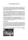
The wool for making skirts was dyed with herbal dyes. The bedstraw root was particularly widely used to produce red colouring. Indigo was the first dye to be widely bought during the 18th century. Today Estonian traditional costume is the most spectacularly exposed at "laulupidu", the national song festival, both on the stage and among the audience. Local differences were noticed by the first ethnographers describing Estonians. The main regions fall into South, North, and West Estonia, and the islands as a separate group, reflecting ancient tribal peculiarities. South Estonia This region is the most conservative in dress. Maidens in Southern Estonia bound their hair with a ribbon plaited from colourful pieces of cloth or woollen yarns. Instead of a skirt, the Setu women wore a garment resembling the Russian sarafan. Setu women were extremely fond of silver ornaments: on their chest they wore a conical brooch, in addition to various silver chains
When you travel about the country you can see how the scenery changes right in front of your eyes. Highlands turn into lowlands; forests and hills turn into meadows and plains very quickly. It's hard to believe, but in Great Britain one you can find practically any type of scenery. Britain is unusually beautiful country! England can be divided for four parts: the Southeast, the Southwest, East Anglia, the Midlands and the North of England. The Southeast is a highly populated region of England. London, the capital of the UK, and such historical cities as Windsor, Dover and Brighton are situated here. When people travel to Britain by sea or by air they usually arrive in the Southeast, for this is where the main passenger ports and airports are. Heathrow airport, one of the world's busiest airports is about 33 km west of central London
but sometimes it’s abnormal how much teacher give you a homework. The school atmosphere is very good in our glass but our glass doesn’t speak a lot to our parallel glass because they really hate us. What are the biggest pressures for teens in your city? Võru doesn’t have many pressures but maybe the biggest problem is that in Võru there is no place to be with your friends. In our city luckily is no problem with criminality. Is there a difference in Estonia between the north and the south? No, our country is small and there aren’t big differences. Maybe the biggest difference is that south has many dialects and the north doesn’t understand our language. Also north has bigger salary and for that lives better. Have you visited any other countries? Yes, I have visited many countries. Finland, Latvia and Lithuania for many times, that’s more than three times. Also Poland for once. What is your ambition for the future?
The United States of America (The U.S.A) Geography The main part of the United states extends from the Atlantic Ocean in the east to the Pacific Ocean in the west. It covers the middle of the North American continent. This area is called ,,the continental United states". The continental United States is bounded to the North by Canada and to the South by Mexico. The border with Canada is often called ,,the longest unguarded border in the world". The United States and Canada are good friends and they have very few problems in managing the border. The borded with Mexico is different. Immigrants are constantly crossing the border illegally. Every day about 2,000 of them are captured and sent back, but may others get through. There are also two states that are not connected to the continental United States
We use the with plural names of people and places: People the Taylors (=the Taylor family), the Johnsons Countries the Netherlands, the Philippines, the United States Groups of islands the Canaries / the Canary Islands, the Bahamas, the British Isles Mountain ranges the Rocky Mountains / the Rockies, the Andes, the Alps · The highest mountain in the Alps is Mont Blanc. North / norhtern etc: We say: the north (of France) but northern France the south-east (of Spain) but south-eastern Spain Compare: · Sweden is in northern Europe but Spain is in the south. Also: the middle east the Far East You can also use north / south etc. + a place name (without the): North America West Africa South-East Spain Note that on maps, the is not usually included in the name.
Introduction The aim of this research is to get know more about the Netherlands history and its geographical facts. This report is describing one of most the most beautiful countries in the Europe - Netherlands. Netherlands is famous for its windmills and flowers. Netherlands is also known unofficially as Holland. Government is constitutional monarchy of north-western Europe. Netherlands is bordered on the north and west by the North Sea, on the east by Germany and on the south by Belgium. The European portion of the Netherlands has a total area of 41,528 sq km of which 33,939 sq km is land surface. Country's capital and largest city is Amsterdam. Population is about 16 million. 3 Chapter 1 The Netherlands 1.1 Mainly about the Netherlands Netherlands is also known unofficially as Holland
Italy Sicily Capital: Rome Size: 301,230 sq km Population: 57,6 million San Marino The Vatican City Highest point: Mont Blanc (4,807 m) The Alps in the north and the Apennines in the center of Italy The north of Italy: cold, harsh winters but hot and humid summers Central Italy: smaller temp. difference between summer and winter The south of Italy: warm and hot summers, mild winters Click to edit Master text styles Second level Sicily- Tonnara di Scopello Third level Gargano Fourth level
GEOGRAPHY Estonia lies of the eastern coast of the Baltic sea. Total area of Estonia is approximately 45000 square kilometer and the population is about 1.5 million . Estonia is one of the most sparsely populated country in Europe. With 35 people per square kilometer. Nearly 1/3 of the nation live in the capital Tallinn. Along the coast of Estonia lies many bays and peninsulas. Lots of islands lie off the west- and north coast. The largest of them are Saaremaa and Hiiumaa. Geographically Estonia can be divided into 4 parts: North-, South-, West-, and East-Estonia. North-Estonia is relatively flat. Here is a nice coastline with coves, capes and a high coast. South-Estonia is more hillier, but there aren't any mountains or mountain ranges. The highest peak in Estonia is Suur Munamägi and its 318m above sealine. The largest industrial areas are situated in East-Estonia. There are beautiful
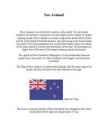
New Zealand New Zealand is on of the first countries in the world. It to be located southeast of australia.It consists of two main islands and a number of smaller outlying islands. New Zealand's two main components are the North Island and the South Island.The North Island is only half as big as the South Island, but nearly 75% of the population live on the North Island. About two-thirds of the south Island is covered with mountains. More than 220 mountains are higher than 2000 meters.The largest outlying island is Auckland. The capital of New Zealand is Wellington, it is the southermost national capital city in the world. It is New Zealand's sixth largest city behind the Auckland. The Flag of New zealand is a defaced blue Ensign with the union flag in the
Estonian geography The territory of Estonia covers 45,227 km2. Estonia is situated in the Baltic Region of Northern Europe. It is bordered to the north by the Gulf of Finland, to the west by the Baltic Sea. Its neighbor countries are to the south Latvia, to the east Russia, to the north and over the Gulf of Finland, Finland and to the west and over the Baltic Sea, Sweden. Most of the lowland areas are in the middle of Estonia. Average elevation reaches only 50 meters and the country's highest point is the Suur Munamägi in the southeast at 318 meters. There is 3,794 kilometers of coastline marked by numerous bays, straits, and inlets. The number of islands and islets is estimated at some 1,500. Two of them are large enough to constitute separate counties: Saaremaa and Hiiumaa
Museum Duxford · In 1978 the Royal Navy cruiser HMS Belfast became a branch of the museum, having previously been preserved for the nation by a private trust. · In 1984 the Cabinet War Rooms, an underground wartime command centre, was opened to the public. · From the 1980s onwards the museum's Bethlem building underwent a series of multimillion-pound redevelopments, completed in 2000. · Finally, 2002 saw the opening of Imperial War Museum North in Trafford, Greater Manchester, the fifth branch of the museum and the first in the north of England. · The museum's collections include archives of personal and official documents, photographs, film and video material, and oral history recordings; an extensive library, a large art collection, and examples of military vehicles and aircraft, equipment and other artefacts. · The museum is funded by government grants,
Tallinna Tehnikakõrgkool EI 12 Madis Arula Introduction Laiuse Castle of Order Laiuse Drumlin Laiuse Blue Spring Põltsamaa Castle Põltsamaa Church Põltsamaa Rose garden Endla Nature Reserve Laiuse Castle of Order ·Rebuilt in the 15th century ·Destroyed 1700-1701, during the North war ·Swedish king Carl XII stayed there during the North war Laiuse drumlin ·10 kilometrs long ·2 kilometrs wide and ·Higest topp is 144 meters above the sea Laiuse blue spring ·18 m deep ·Healing qualities Põltsamaa castle and church ·Started in 1272 ·1770 the old building was replaced by a rococo palace ·Built from 1632 to 1633 ·In 1941 It catched fire and the
Rahvusvahelised organisatsioonid Euroopa liit- 27 riiki, poliitline majandusliit, prioriteet religioonse ebavõrdsuse vähendamine, toimib liikme maksudest WTO- world trade organisatsion- e maailma majandus org, eesmärgiks elatada maailma kaubandust, alandada tollijakaupade tariife NAFTA- north american free trade agreement- e põhja ameerika vabakaubandus leping, liikmesriigid on usa,kanada,mehhiko, kaubandus org- kaotatud pmst kõik kaubandus tõkked ASEAN- assocation of south east asian nations- e kagu aasia riikide ühendus, kaubanduslik org G20- lobal twenty- maailma juhtivad tööstusriigid, toimub igaastane tippkohtumine( maailma poliitika põhisuundade paika panekuks) MERCOSUR- south common market- e lõuna ühisturg, brasiilia,baraquai,uruqai,argentiina, vabakaubandus liit
Ireland Jaan Paljak Class 9 21.11.2011 Geography • The island of Ireland is located in the north-west of Europe, between latitudes 51° and 56° N, and longitudes 11° and 5° W. It is separated from the neighbouring island of Great Britain by the Irish Sea and the North Channel. • A ring of coastal mountains surround low plains at the centre of the island. climate The climate of Ireland can be summed up as being mild, moist and changeable with abundant rainfall and a lack of temperature extremes. The country receives generally warm summers and mild winters, and is considerably warmer than other areas on its latitude. This is due to the fact it lies in the Atlantic Ocean, and as a result is warmed by the Gulf Stream all year.
Angles gave England its name. The population nowadays is about 60 million people UK lies off the north-west coast of mainland Europe. The climate in UK is generally mild and temperate. The climate is greatly influenced by the surroundig days. It is said you can experience four seasons in one day. The longest river is The Severn which is 240 miles long. The most famous English river The Thames is 215 miles long. Lakes can be found in the north of England, in and Area called Lake District. The most beautiful lakes are in Scotland. British mountains are low. The highest peak Ben Nevis is 4.406 feet. The biggest towns are London, Birmingham, Leeds, Glasgow, Sheffield, manchester and Liverpool. The United Kingdom is a constitutional monarchy. The monarch is expected to be politically neutral and should not make political decisions. The present sovereign is Queen Elisabeth II
Avarage Canadian is... hospitable tolerant following a live and let live philosophy with strong sense of community and duty Canadians invented basketball baseball glove lacrosse Lacrosse mix between soccer and hockey 10 players 3 attackmen, 3 midfielde, 3 defensemen and 1 goalkeeper Canada has worlds longest coastline onetenth of the worlds forests longest national highway in the world Great Slave Lake deepest lake in North America in the 1930s, there was discovered gold max depth of 614 m Canadian Rockies highest point is Mount Robson second highest point is Mount Columbia Toronto largest and most important city financial centre in Canada have only real castle in all of North America Ottawa capital of Canada one of the nation's youngest cities have three universities Canada timeline Thank you for listening !
The Inuksuk Marit & Mari- Liis 9b symbol in the Arctic built from the stones "likeness of a person"( inimese sarnane) Used in many different ways. the way home warn of dangerous places showed where food was stored help hunt caribou herds (karjad) work of humans many Inuit lived on the sea ice stars in the night sky were important. Some Inuksuit were built to point toward the North Star Today much more than just a stone marker( kivid) symbol of the North and of leadership Traditional to mark their presence both in the Arctic and across this country. http://www.flickr.com/photos/aqaf33/6092241093/ http://www.pic2fly.com/Inutchuk.html http://www.google.ee/imgres? q=inutshuk&hl=et&biw=1680&bih=949&tbm=isch&tbnid= 5WUEz5RgVmQirM:&imgrefurl=http://aygues-vives- luzenac.com/En_Lesgites
Canada is the second largest country in the world. Situated to the north of the United States, in North America, it has both English and French as its official languages. Even though its area is bigger than that of the United States, its population is only about 11% of that of the USA some 35 million. Because of that, Canada has one of the lowest population densities in the world. The capital of Canada is Ottawa the name of whose comes from the old Algonquin language, with the original word meaning `to trade'.
money or the time to spend on that colony. France and Britain didn't have good relations; they fought over colonies, fur trade and religion. In 1756 Seven Years' War started between them. The British colonists wanted new farmland and French fur traders had forts, which they refused to move. By 1758, the British had conquered the French fortress of Louisbourg at the entrance of the St. Lawrence River. This was the beginning of the end for French rule in North America. In September 1759, the British attacked the French on the Plains of Abraham and won. The following spring they also conquered Montreal. The British renamed the new French-speaking region Quebec. They allowed the French to keep their Roman Catholic religion, civil law system and language, so that they would not try to break away from Britain. From 1775 to 1784, many British came to the former New France area from south. The
USA ajaloo konspekt (algus-Mayflower Compact) 1. Name the regions of the USA New England, Middle Atlantic, South, Midwest, Southwest, West. 2. Name the states that make up each region. NE: Maine, New Hampshire, Vermont, Massachutsess, Rhode Island, Connecticut. MA: New York, Pennsylvania, New Jersey, Maryland, Delaware. S: Virginia, North Carolina, South Carolina, Georgia, Florida, Alabama, Mississippi, Louisiana, Missouri, Arkansas, Kentucky, Tennessee, West Virginia. MW: North Dakota, South Dakota, Nebraska, Illinois, Michigan, Kansas, Minnesota, Iowa, Indiana, Wisconsin, Ohio. SW: Arizona, New Mexico, Texas, Oklahoma. W: Washington, Oregon, California, Hawaii, Alaska, Montana, Idaho, Nevada, Colorado, Wyoming, Utah. 3
Grampian Mountains which forms with some other mountains a huge mountain mass. The Central Lowland lie south of the Scottish Highlands. This region is a gently rolling plain. It has best farmland, and richest coal deposits. The Southern Uplands rise gently south of the Central Lowlands. This is a region of rounded, rolling hills. 4.What are the possibilities of land use in Scotland? Tourism in the mountains, there you can ski and climb mountains. In the north there doesn't live much people, so there people raise sheep or go fishing. In the Central Lowlands, people earn living from farming and there is Scotland's richest coal deposit. In the Southern Uplands people graze sheep. 5.Describe the relief of England. England's terrain mostly comprises low hills and plains, especially in central and southern England. However, there are uplands in the north, for example there are the Pennines, which is a region of rounded uplands
Germany, Switzerland, Italy, Monaco, Andorra, and Spain. France's overseas departments and collectivities also share land borders with Brazil and Suriname and the Netherlands Antilles. France is the largest country in the European Union by area and the second largest in Europe behind Ukraine. France has been a major power for many centuries with strong economic, cultural, military and political influence. During the 17th and 18th centuries, France colonized much of North America; during the 19th and early 20th centuries, It is the most visited country in the world, by about 82 million tourist. French capital is Paris. President is Nicolas Sarkozy .France is ranked as the first tourist destination in the world, ahead of Spain and the United States. France is the 19th most populous country in the world. France's largest cities are Paris, Marseille, Lyon, Lille, Toulouse, Nice, and Nantes.
of tides, which means that most mangroves get flooded at least twice per day. The roots also slow the movement of tidal waters, causing sediments to settle out of the water and build up the muddy bottom. KAARDIGA SLAID Mangroves can be found in over 118 countries and territories in the tropical and subtropical regions of the world. The largest percentage of mangroves is found between 5° (degrees hääldad seda kraadi märki) North and 5° South latitudes.[20] Approximately 75% of world's mangroves are found in just 15 countries. Asia has the largest amount (42%) of the world's mangroves, followed by Africa (21%), North/Central America (15%), Oceania (12%) and South America (11%). Ülejäänud info on slaidide juures olemas ja nende kohta pole rohkem pikemalt midagi öelda. Proovid ise pikemalt seletada.
The USA The United States of America (also called the United States, America, and the States) is a federal constitutional republic. The country is situated mostly in central North America, where its forty-eight contiguous states and Washington D.C., the capital district, lies between the Pacific and Atlantic Oceans, bordered by Canada to the north and Mexico to the south. The state of Alaska is in the northwest of the continent, with Canada to the east and Russia to the west across the Bering Strait. The state of Hawaii is an archipelago in the mid-Pacific. The country also possesses several territories in the Pacific and Caribbean. The United States is the world's oldest surviving federation. It is a constitutional republic and representative democracy. The government is regulated by a system of checks and balances defined by the U.S
Representatives. There are a hundred people in the Senate (two from each state) and 435 people in the House of Representatives. At the head of the Judicial branch is the Supreme Court, which has nine judges. The leading parties in America are the Democrats and the Republicans but there are also other parties. Location The United States of America is situated in the central part of the North American continent. Its western coast is washed by the Pacific Ocean and its eastern coast is washed by the Atlantic Ocean and in the south its coast is washed by the Gulf of Mexico. The coastline is even. There are no big islands belonging to the U.S. except the Hawaiian Islands which lie halfway the continents of America and Asia. The biggest peninsulas are the Florida Peninsula and Alaska. The United States of America has got three neighbours Mexico in the south, Canada in
Following several years of abandonment, the castle was partially restored by the Maxwells in 1847, to honour Queen Victoria's visit to Glasgow. In 1931, Crookston became the first property acquired by the National Trust for Scotland, having been presented by Sir John Maxwell Stirling-Maxwell Today, Crookston Castle is a Scheduled Ancient Monument, and a Category A listed building. Its maintenance is the responsibility of Historic Scotland.Crookston Castle sits atop a natural hill.To the north is a steep drop to the Levern Water. The castle has a rectangular main block, which was strengthened by a tower at each corner. This formed an irregular 'X-plan' shape, an unusual layout also seen at Hermitage Castle. Only the north-east corner tower survives to its former height, as well as the basement of the south-east tower. The two western towers were destroyed in the 15th century and never rebuilt, repairs in the 19th century have obscured even the remains of these
6. Towns, economy, agriculture 7. Climate 8. Animals, plantlife 9. Population 10. Sports 11. Culture 12. History 13. Political system, symbols 14. Conclusion 15. Materials 1. Introduction If you had to use two words to describe Canada, they might be large and diverse. Canada is the second largest country in the world, bordered by three oceans, and across the country, Canadians experience many different landscapes from rolling plains and mountains to the cold tundra of the north. Despite Canada's great size, it is one of the world's most sparsely populated countries. This fact, coupled with the grandeur of the landscape, has been central to the sense of Canadian national identity. 2. Geographical position Canada is the second largest country in the world after Russia. In the Arctic, Canada reaches almost as far north as Greenland. To the south it extends to the same latitude as southern France. The distance from Canada's west coast, the Pacific Ocean, to its
allied with Tostig Godwinson, had landed ten miles from York; Harold was forced to march against them. · Duke William landed at Pevensey Before Harold could return from York to south south William landed his army at Pevensey Bay . Then he decided to move to Hastings, where he built a prefabricated wooden castle for a base of operations. From there, he ravaged the hinterland and waited for Harold's return from the north. · Harold Godwineson returned to London. William chose Hastings as it was at the end of a long peninsula flanked by impassable marshes. Battle was on the isthmus. Harold had been reconnoitering the south of England for some time and well appreciated the need to occupy this isthmus at once. Battle of Hastings · The English army -7,500 men The English army had fought a major battle at Stamford Bridge in Yorkshire less than three
Area. Population. Climate The total area is 268,680 km² and the population is approximately 4,266,000. The density of population is about 16.1/km2. New Zealand's area is a bit smaller than Italy's or Japan's but bigger than England's. The biggest of New Zealand's islands is South Island. On the South Island there are 18 mountains that are higher than 3000m. The highest mountain is Cook mountain - it's 3754m high. North Island isn't as mountainous as South Island but it's volcanic. The highest mountain there is Ruapehu mountain - it's 2797m high and currently active. The landscape of New Zealand is very popular with making movies and TV- shows - for example the trilogy of "Lord of the Rings" and "The Last Samurai" are filmed there. The climate is temperate all over the country. The temperature rarely goes under 0°C or over 30° in populated areas. The weather on the west coast is moist and cool
Geography New Zealand is an island country in the Southwest Pacific Ocean. It lies about 1600 kilometres southeast of Australia, its nearest continental neighbour. New Zealand belongs to Polynesia, a large island group. The country consists of two main islands The North Island and the South Island and several dozen much smaller islands. The population is 4.1 million. New Zealand is a beautiful country of snowcapped mountains, green lowlands, beaches and many lakes and waterfalls. No place is more than 130 kilometres from the coast. Lakes, rivers, and waterfalls are found throughout New Zealand. Most of the lakes lie in the volcanic plateu of the North Island and in glacial valleys near the Southern Alps of the South Isaland
Scotia, Ontario, Prince Edward Island, Quebec, Saskatchewan, Newfoundland ) along with two territories( the Yukon, the Northwest territories ). The capital city is Ottawa. Canada is a country rich in forests. It borders in the south with The United States and it's surrounded in the west by the Pacific Ocean, in the east by the Atlantic Ocean and above by many smaller bays, but is also borderedd with Alaska in the north-west. To the north of Canada is the broad Canadian Shield, an area of rock scoured clean by the last ice age, thinly soiled, rich in minerals, and dotted with lakes and rivers. Canada by far has more lakes than any other country and has a large amount of the world's freshwater. You can see more lakes in the south eastern part, on the U.S.A's border, including the famous waterfall Niagara Falls. The eastern areas of Canada are occupied by the Saint Lowrence Lowlands. The Saint
Estonia Where it is? Republic of Estonia is a state in the Baltic region of Northern Europe .It is bordered to the north by the Finland, to the west by the Baltic Sea, to the south by Latvia (343 km), and to the east by lake Peipus and Russia (338.6 km). Across the Baltic Sea lies Sweden in the west and Finland in the north. Towns Tallinn is the capital and the largest city of Estonia. It lies on the northern coast of Estonia, along the Gulf of Finland. There are 33 cities and several town-parish towns in the country. In total, there are 47 linna, with "linn" in English meaning both "cities" and "towns". More than 70% of the population lives in towns. History • Estonia was settled near the end of the last glacial era, beginning from around 8500 BC
The United States The country is situated mostly in central North America. The capital district, lie between the Pacific and Atlantic Oceans, bordered by Canada to the north and Mexico to the south. The United States is the third or fourth largest country by total area. It is one of the world's most
Christmas time The elves were very busy at the last Christmas. They ran around in the North Pole. In Santa's toy factory were busy times, because all gifts weren't finished. Also there were problems with reindeers, little elf Ville forgot to feed them and no they were ill. Santa was little bit upset. Ville was sad, he thought he ruined the Christmas, Ville wanted to make a gift for Santa. Elf boy Ville went to in to the deep forest, he had heard that in this forest live magical creatures who can fulfill your desires. Ville saw a bonfire behind the trees, he went there and he
ENGLAND England is a country that is part of the United Kingdom. It shares land borders with Scotland to the north and Wales to the west; it is surrounded by the Irish Sea, the Celtic Sea, the North Sea and the English Channel, it's linked to Frane by the Channel Tunnel. The total area of the country is more than 130000 sq km. Most of England is lowland, but there are upland regions in the north, south and south west. The climate is temperate, subject to frequent changes, with plentiful rainfall all year round, although the seasons are quite variable in temperature, it rarely falls below -5 or rises above +30 degrees. The longest river, the Severn, flows for 354km. England's capital London, is the largest metropolitan area in the United Kingdom, drawing from a wide range of people, cultures and religions, speaking over 300 different languages, mixing
The territory of Estonia covers 45,227 km² with a population of only 1,34 million, Estonia is one of the leastpopulous member of the European Union. Estonia is one of the more sparsely populated countries in Europe, only 35 people per square kilometers. Nearly the third of the population live in Tallinn, the capital of Estonia. There are many bays and islands located along the coastline of Estonia. There are great number of islands away from the west and north shore. The biggest of these are Saaremaa and Hiiumaa islands. Geagraphically Estonia can be devided into four: North, South, Western and Eastern Estonia. North Estonia is quite flat and low. Here are very nice waterfront brights with its capes and cliffs. SouthEstonia is more hilly, but here are no mountains or mountains chains. The highest point of Estonia the SuurMunamägi (the Great Egg Mountain) is here in SouthEstonia. It is 318 meters above sea level
and it is bordered by three oceans: the Arctic, the Pacific and the Atlantic Oceans. The population of Canada is about 31 million people. About 77% of the people live in cities which lie in a band about 100 miles wide above the border of the United States. The capital of Canada is Ottawa. Other large cities are Montreal, Toronto, Vancouver, Winnipeg and Quebec. 2. Geographical position Canada is a huge country in the continent of North America. It is bordered with the Atlantic Ocean in the east, the Pacific Ocean in the west, the United States of America in the south and the Arctic Ocean in the north. Canada is a vast country, with a territory of 3.8 million square miles of land and fresh water it is the second biggest country in the world after Russia. Canada covers most of the northern part of North America. Canada has over 151,480 miles of coastline
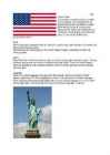
white and represent the Thirteen Colonies. The 50 small, white stars represent the 50 U.S. states. The U.S. flag is commonly called ,,the Stars and Stripes". The Statue of Liberty, that is locatd in New York,is a gift from the France. The Libety Bell, that is a bronze bell that symbolizes freedom in the United States of America. It is located in Pennsylvania,U.S. Capital: Washington D.C Biggest city: New York National language: English Location U.S is located in North America, bordering both the North Atlantic Ocean and the North Pacific Ocean. United States neighbour countries are Canada and Mexico. The USA has the 8th longest coastline in the world at ~20 000 km. 62% of the perimeter of the USA is coastline. The USA's coastline is made up of beaches, cliffs, mangroves, and urban and developed areas, which make America very versatile country. Political division United States of America distributes into 50 states
CANADA Canada is a vast country, second largest country of the world after Russia. It stretches from the Atlantic Ocean in the east to the Pacific Ocean in the west and to the Arctic Ocean in the North. Canada Covers most of the northern part of North America and its geography is very diverse. Canada's area is about 10 million square kilometers and its population is 31 000 000. Its capital is Ottowa and other main cities are Toronto, Montreal and Vancouver. Almost 75 % of canadians lives within 300 kilometer of the USA border, because the climate is softer in the South. 89 % of Canada is almost unhabited. Its official languages are English and French, but many other languages are spoken too
Western Australia Mihkel Hallen 8b Introduction · Western Australia is the largest state of Australia · It's population is 2,1 million inhabitants (10% of the national total) · The state's capital city is Perth The flag History · The first inhabitants of Australia arrived from the north approximately 40,000 to 60,000 years ago · The first European visited W.A. in 1616 · Population growth was very slow until the significant discoveries of gold were made in the 1890s Geography · Western Australia is bounded by South Australia and the Northern Territory to the east, and the Indian Ocean to the west and north · It's highest peak is the Mt Meharry (1249m) Climate · The southwest costal area is relatively
Report Title: ,,Frankenstein'' Author: Mary Shelley Genre: Novel Setting (time): 19th century Setting (place): North Pole, Europe (Switzerland, Scotland, England) Tone: magical, dark, mysterious, ghostly Themes: love, loneliness, science, human tendency Introduction Frankenstein was first published in March, 1818. This book is also known as The Modern Prometheus. Frankenstein is one of the most popular works of gothic horror and science fiction literature and it is considered to be one of the best known novels of English Romanticism. Characters
NB! the Estonian language Haigused: Ilmakaared: pneumonia the west appendicitis the south-east NB! flu/ the flu, mumps/the mumps, a cold the western Europe the Middle East the West End NB! Northern Ireland North America South-Eastern Spain Loendamatute nimisõnade juurde kuuluvad Organisatsioonid, riigiorganid: sõnad, mis tähistavad rahvust, päritolu või the United Nations ajastut: the European Union Italian music the police British culture the army new age the BBC modern art
USA General information is a federal constitutional republic comprising fifty states and a federal district The country is situated mostly in central North America, where its forty-eight contiguous states Capital: Washington D.C Largest city: New York City There isn't official language Currency: United States dollar ($) President: Barack Obama ( Barack Hussein Obama II) Flag Names: The Stars and Stripes, Old Glory, The Starry Banner Seal: Great Seal of the United States Motto: In God We Trust 9.83 million km2 and with over 308 million people, the United States is third largest country both by land area and population
freeholders from the franchise. The Irish Parliamentary Party strove from the 1880s to attain Home Rule self-government through the parliamentary constitutional movement eventually winning the Home Rule Act 1914, though suspended on the outbreak of World War I. In 1922, after the Irish War of Independence, the southern twenty-six counties of Ireland seceded from the United Kingdom (UK) to become the independent Irish Free State -- and after 1948, the Republic of Ireland. The remaining six north eastern counties, known as Northern Ireland, remained part of the UK. The Irish tricolour I chose the Irish history, because I have always loved history and reading/writing about it. Used literature http://en.wikipedia.org/wiki/Ireland http://en.wikipedia.org/wiki/History_of_Ireland