Leidsid 33 sarnast õppematerjali, mis on seotud failiga "Easter island". Need materjalid aitavad sul teemat sügavamalt mõista.
easter, island, pacific, ocean, hanga, crater, there, madrid, santiago, euros, everybodyThe Easter Island Made by: Käty Kivirand Studygroup: MY08 Supervisor: Lugina Olga Easter Island(Rapa Nui, Spanish: Isla de Pascua) is a Polynesian island in the southeastern Pacific Ocean, at the southeastern most point of the Polynesian triangle. Easter Island is one of the most remote islands on Earth. Easter Island is only 15 miles long and 10 miles wide. The Polynesian Triangle is a region of the Pacific Ocean anchored by three island groups: Hawaii, Easter Island and New Zealand, often used as a simple way to define what constitutes Polynesia. The island has an area of 163.6 km2. Population is about 3791 (3304 people living in the capital of Hanga Roa). On July 11, 2010 at 18:15:15 a total solar eclipse occurred for the first time in Easter Island in over 1,300 years. Lan Chile flies to Easter Island, with flights operating between Santiago, Chile and Papeete,Tahiti. Airfare from Santiago,Chile to
My dream destination is... FRENCH POLYNESIA The French Polynesia islands are located in the Pacific Ocean. It contains of many islands. The most famous are Tahiti, Bora Bora, Moorea. The islands are considered to be one of the most exotic places in the world; also known for its breathtaking beaches. The official language is French. SIGHTS Tahiti's volcano Rangiroa atoll Papetoai temple in Moorea Lagoon of Bora Bora Museums and botanical gardens in Tahiti Aquariums and zoos Tahitian dancing THINGS TO DO Jet skiing in Bora Bora
Other big cities are Melbourne, Sydney, and Brisbane. National language in Australia is English. Monetary unit is Australian dollar. Their national holiday is on the 26th of January. In 1788 on the 26th of January the first fleet arrived at Botany Bay and established a penal colony near modern-day Sydney. Geographical Position Australia is located in the Southern Hemisphere. It’s the only continent except for Antarctica that is all south of equator. Sometimes Australia is called the island continent. There is a great reason why. It really is an island. It is 2880 km from the mainland of Asia and is almost half way round the world from Europe. More than 9 600 km separates it from America. Australia lies between the Pacific and Indian oceans. The Timor Sea and the Arafura Sea separate Australia from Indonesia. In the north the coast is washed by Great Australian Bight and the Indian Ocean. In the northeast the Coral
New Zealand New Zealand is an island country. It is in the south-western Pacific Ocean comprising two main island, North- and the South Island with lots of smaller islands. New Zealand is notable for its geographic isolation. It's about 1,600 kilometers from Australia and its closest neighbours to the north are New Caledonia, Fiji and Tonga. New Zealand's total land area is 268,021 square kilometers. The country extends more than 1600 kilometers along its main,north - north-east axis and has about 15,000 kilometers of coastline. The South Island is the largest land mass of New Zealand and is divided along its
1. How many public holidays or Red-Letter Days are there in Britain? Name them. 8 public holidays in Britain: two at Christmas, one for the New Year(which was only introduced in the late 1970s) two at Easter and three Bank Holidays. 2. What is the same and what is different about the way Christmas is celebrated in England and Estonia? In England, there's common to sing Carol's and for children, Christmas means pantomimes plays based on fairy tales which combine comedy, dance and song. A traditional Christmas dinner includes roast turkey with roast potatoes, a range of vegetables, cranberry sauce etc., followed by Christmas pudding and Christmas cake
Usa 1. Gross Domestic Products Gross Domestic Products of USA United States of America has the highest Gross Domestic Products nominal about 14.624 trillion US dollars according to World Bank. 2. Rhode Island Rhode Island is actually named Rhode Island and Providence Plantations and it makes the smallest state in the United States has the longest name. 3. Califrnia never rains It is believed that California is the state with the lowest rainfall in the world. For two years, California never rains. For those amazing and unique facts, California has been attracting so many tourists. Many people also adore this fact and this facts is often included in a song lyric. 4. President Grover Cleveland
The United States of America (The U.S.A) Geography The main part of the United states extends from the Atlantic Ocean in the east to the Pacific Ocean in the west. It covers the middle of the North American continent. This area is called ,,the continental United states". The continental United States is bounded to the North by Canada and to the South by Mexico. The border with Canada is often called ,,the longest unguarded border in the world". The United States and Canada are good friends and they have very few problems in managing the border. The borded with Mexico is different. Immigrants are constantly crossing the border illegally
............................................... 8 Prepositions of Time – in, on & at • in is used with centuries, decades, years, seasons and months, parts of the day, periods of time • on is used with dates, special days, days of week, day of week + part of day, day + of ... • at is used with holidays, exact time, meals and with night in on at • the 20th century • the 29th of November • Christmas / Easter • the Middle ages /August the first • six o’clock / 7.30 • the 1980s • Christmas Day / New • midday / noon / • 2006 Year’s Eve / Easter midnight • winter / summer Sunday • the weekend / • May / August / • Wednesday(s) weekends November • Monday morning • breakfast
The Executive power in Australia is in the hands of the Commonwealth Government lead by the Prime Minister. Today the Prime Minister is John Howard, the leader of the Liberal Party. History Australia was once a part of the giant continent Gondwana. It included Africa, South America and Antarctica. First Australia and Antarctica split from Gondwana, then Australia broke away from Antarctica and began to move north. Aborigines arrived there about 50 000 years ago. They had occupied the whole continent by 30 000 years ago. At that time Tasmania was still part of the mainland. About 20 000 years ago the ice began to melt and the rising water level cut Tasmania off from the mainland. Traders from what is now Indonesia are thought to have been visiting Australia well before the 17th century. Chinese, Malaysian and Arab sea Captains may also have landed in Northern Australia after the 15 th century.
1) INDIAN ROCK ART: A NATIONAL TREASURE IN DANGER Unrecognized, unprotected, this priceless legacy of primitive art has endured the ravages of nature only to fall victim to wanton destruction by ,,civilized" man. Like the huge stone statues of Easter Island and prehistoric cave paintings of Altamira and Lascaux, North American Indian rock art is surrounded by an atmosphere of mystery. Although examples of rock art exist at some 15000 sites in canyons, deserts, caves and river gorges. Nowadays, however, primitive rock art in the United States has become a new field of scientific study. Klaus F Wellmann wrote two books about rock art. He is a professor of medicine. Rock art represents the history of aboriginal Americans
A We use adverbials of time to say when something happens. We often use noun groups called time expressions as adverbials of time. yesterday, today, tomorrow last year, next Saturday, next week the day after tomorrow, last night, · the other day · Do not use the prepositions `at', `in', `on'!!! Prepositional phrases as adverbials of time: `at' is used with: clock times: at eight o'clock, at three fifteen religious festivals: at Christmas, at Easter mealtimes: at breakfast, at lunchtimes specific periods: at night, at the weekend, at weekends, at half-term `in' is used with: · seasons: in autumn, in the spring years and centuries: in 1985, in the year 2000, in the nineteenth century months: in July, in December parts of the day: in the morning, in the evenings Note that we also use `in' to say that something will happen during or after a period of time in the future. · I think we'll find out in the next
Canada 8a Teacher: Merike Sisask Composer: Kärt Kalvet 2010 Canada, Kärt Kalvet 8a Canada General Information Canada is in North America. It's area is 9220970 sq km. Canada's population is 313.612.000 people. Canada is divided into 10 provinces and 3 territories. The capital of Canada is Ottawa. Canada has constitutional monarchy. The head of state in Canada's government is the Queen of England. There are two main languages in Canada: English and French. Canada's curreny is Canadian dollar (1 dollar=100 cents[Can$]). The highest peak of Canada is Mount Logan, 5959 metres. The lowest point is sea level. The longest river is the Mackenzie. The climate and geography of Canada vary greatly from temperate in the south to arctic in the north and from islands and plains in the east to mountains in the west. Location Canada is located in the northern-most region of North America
The county of Saaremaa Siiri Tabri Kaia Vask Saaremaa - an exciting island Saaremaa - the biggest island of Estonia is known as a good recreation place with unique nature and a lot of sights. Saaremaa has retained its uniqueness due to its location and insulation. Junipers, dolomite, windmills and the famous local home- brewed beer are considered the symbols of Saaremaa. Rich nature. Because of its mild maritime climate and soil rich in lime, Saaremaa has very rich flora and fauna. In Saaremaa a great number of Roman snails, rare butterflies and
TSUNAMI Kristjan Sillaots G1R2 WHAT IS TSUNAMI? A tsunami is a series of ocean waves that sends surges of water, sometimes reaching heights of over 100 feet (30.5 meters), onto land. These walls of water can cause widespread destruction when they crash ashore. WHAT CAUSES A TSUNAMI? These awe-inspiring waves are typically caused by large, undersea earthquakes at tectonic plate boundaries. When the ocean floor at a plate boundary rises or falls suddenly, it displaces the water above it and launches the rolling waves that will become a tsunami. WHAT CAUSES A TSUNAMI? Tsunamis may also be caused by underwater landslides or volcanic eruptions. They may even be launched, as they frequently were in Earth’s ancient past, by the impact of a large meteorite plunging into an ocean. TSUNAMI
Largest Cities........................................................................................5 4. Culture...........................................................................................................6 5. Conclusion .....................................................................................................7 6. References .....................................................................................................8 Introduction New Zealand is an island country in the southwest of Oceania. The Tasman sea separates New Zealand from Australia. The basic parts of New Zealand are the North Island and the South Island. Wellington - which is located on the South Island - is the most southern capital city in the world, but the biggest city in New Zealand is Auckland. There are three official languages in New Zealand: English, Maori and the New Zealand's Sign Language. In Maori language the island is also called Aotearoa
Its territory is about 9.4 million square kilometres and its population is more than 260 million people, 12% of them are the Afro-Americans. It is the world's third-largest country by size and by population. The population density is about 27 people per square kilometre. Most of the people live in towns. There are 50 states in America. The biggest of the state is Texas, next by size are California, Alaska and Montana. Six states - Maine, Vermont, New Hampshire, Connecticut ,Rhode Island and Massachusetts are called New England. They are all small states in the U.S. that lie in the north-east. The first colony of immigrants settled down in Virginia, in the eastern part of the U.S.A. The biggest cities are New York, Washington, Chicago, Los Angeles, San Francisco, etc. The flag of America was adopted on 14 th June 1777. It is called the "Stars and Stripes". It is said that Betsy Ross sewed the first flag. It features 13 horizontal red and
because it is extremely iregular and indented. New Zealand's coastline is packed with deep coves, bays, intricate harbours, long sounds, and steep fiords. Its territorial waters stretch from the sub-tropical through to the sub-antarctic. Both islands tend to have better swimming beaches on their eastern coasts and the further north you go. The west coasts of both islands are quite rugged with cliffs and more unsettled weather. There are however some suitable swimming and bathing beaches here, with iron (volcanic) sand beaches (black sand) being common on the North Island. The longest beach in New Zealand is the 90 mile beach, which is actually about 60 miles long. This beach is famous for its huge sand dunes and resembles the Sahara Desert in places. This beach occupies the north western coastline of the North Island. New Zealand also has some great surf breaks in both islands. The most famous break is
Kaali crater Kaali crater's history Nobody truly knows how old is Kaali crater. Many people think it's over 7000 years old some even think that it is over 3500 years old. There are some rumours that Scandinavian god Thor once landed there :D. Ivan Reinwald was the first human to start investigating Kaali. In 1935 Ivan found meteor shards there and knew a meteor landed there. What can you do there At Kaali it's obvious you can see the crater but there are other fun stuff to do there. You can have a nice picnic with friends at there. Visit the nearby resturants and enjoy the nature. Remember that don't go swimming to the crater! Location Kaali crater is located at Saaremaa (20km NW from Kuresaare). Gheographic coordinates: 58° 22 22 N, 22° 40 10 E Facts The crater is 22m deep and diameter of 110m. At the bottom of the crater is Kaali lake. Scholars still consider the lake as sacred lake
Palace was built in 11th century by man called Charles Barry .It is located on the north back of the River Thames. In 1834 most of it burned, so in 1840 The Palace of Westminister was rebuilt. It is the meeting place of the two houses of the Parliament of the United Kingdom - the House of Lords and the House of Commons. The Houses of Parliament is composed of 1100 rooms, 100 staircases and three miles of corridors. Parliament takes breaks during Christmas, Easter and over the summer. The Palace of Westminster features three main towers The Central Tower, The Victoria Tower and The Clock Tower, also known as Big Ben. The Central Tower stands over the middle of the building, immediately above the Central Lobby. This tower is proof that after the fire in 1834, the palace can still look good. The Victoria Tower is the most striking property of Charles Barry's design for the New Palace of Westminster. At the time when
SUBJECT: ENGLISH BY NIKITA GUSTSHIN TMHG 19.04.2012 "The History of Journalism" What is "Journalism"? Journalism is the investigation and reporting of events, issues and trends to a broad audience. Though there are many variations of journalism, the ideal is to inform the intended audience. Along with covering organizations and institutions such as government and business, journalism also covers cultural aspects of society such as arts and entertainment. The field includes editing, photojournalism, and documentary. History of journalism. Ancient journalism. Note: "Journalism" is often called the first draft of history, but not all of it has to get written down in real time
/No. I'm not Are you waiting for someone? Are you coming on Friday? We usually make questions by changing the word order: we put the first auxiliary verb before the subject: You are Are you? In present simple questions we use do/does: Do you live near here Does the film begin at three? In past simple questions we use did: Did you sell your car? Practise: Is it raining? Is your brother married? Are there any questions you'd like to ask? Is there a station near here? Is there time to buy a newspaper? Were you late this morning? Were you born in Estonia? Was your friend with you last night? Was it cold this morning? Were there many people at the party? Were there any problems? Was there a lot of traffic this morning? Was there anyone you knew? Can you swim? Have you got a car? Have you ever been to Nuustaku? Has it stopped raining yet? Do you come from France? Do you speak English?
climbing specialists. But the big difference of ice-climbing from other "non mass sports" is, that it is also very interesting for spectators and media. As a matter of fact, ice climbing is a fairly new Competition Sport. The first known ice climbing competition was organized in Courmayeur on the Brenva glacier in 1912. Ice climbing competitions started in Russia (at that time the Soviet Union) and have been held each winter since 1970. There were three disciplines: difficulty, speed and speed climbing of a longer route (100+m) by roped groups where the lead climber changed every 40m. The competitions at Courchevel in France were also famous. The main rule was to climb as high as possible using as few hits as possible, with the time limited between 8 and 14 minutes.The magnificent 40m high tower in Courchevel was synonymous for difficulty ice climbing events in Europe from 1995 until
32 % is commercial agriculture. 14 % is logging. 5 % is fuel wood removals. 1 % other causes Atmosphere the climate and geography. global warming. greenhouse effect. Hydralogical The water cycle much drier climate. landslide, erosion and flooding ensue. reforestation In many parts of the world Especially Asia 1 million hectars in 5 years The arbor day foundation Economics Shortterm economic gains. Loss in longterm. Illigal woodcutting. History Easter island 11001500 AD Wester Europe Massive use of charcoal. Steam engine and steamboats. References http://environment.nationalgeographic.com/environment/globalwarming/defores http://en.wikipedia.org/wiki/Deforestation http://wwf.panda.org/about_our_earth/about_forests/deforestation/ Thank you for listening !
Republic of Chile Republic of Chile is a country in South America occupying a long and narrow coastal strip wedged between the Andes mountains and the Pacific Ocean. Chile's unusual, ribbon-like shape -- 4,300 kilometres long and on average 175 kilometres wide -- has given it a hugely varied climate, ranging from the world's driest desert -- the Atacama -- in the north, through a Mediterranean climate in the centre, to a snow-prone Alpine climate in the south, with glaciers, fjords and lakes. The Pacific forms the country's entire western border, with a coastline that stretches over 6,435 kilometres.
For fifty years, it was a musical statement of every Estonian's desire for freedom. http://www.blogto.com/events/3626 Pärnu Hanseatic Days 2008 June 27th 28th Pärnu prepares for the International Hanseatic Days of 2010 by holding handicraft fairs every summer. Traditionally, the Hanseatic Days are declared open by the Mayor who leads the colourful procession from the City Hall to the field of Vallikäär. Among the traders there shall be a stage in the site of the fair, where both singers and actors shall perform. A knights' tournament and several dance shows shall take place. http://www.visitparnu.com/index.php?id=789&L=1 The city of Pärnu has been organizing Hanseatic Days since 2006 with the aim of preparing for the International Hanseatic Days in 2010. The festival is one of the most festive events in the summer in Pärnu. Each year the festival has a historic theme
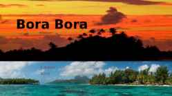
Bora Bora C.Karus 2018 Bora Bora • A tropical island in the Pacific Ocean, famous as one of the top beach destinations in the world • Population – 8 800 • Main languages French and Tahitian • Mount Otemanu, the highest point at 727 metres • Was colonized by Polynesians, New Zealander and explorers such as James Cook in 1777 • Interestingly, there is no "B," in the local Tahitian language, so its actual name is Pora Pora, meaning "first born" Vaitape The largest city Population 4 927 Some supermarkets Many fruits are imported from Faaa Weather And Biodiversity Tropical, humid climate with relatively stable temperatures yearround Characterized by it’s volcanic rock mountains and raised coral beds found at high elevations Coconut palms, pandanus trees, and breadfruit trees cover the landscape. Animal life�
................................8 Culture..........................................................................................................................9 Materials.................................................................................................................... 11 3 Introduction The United States of America is an enormous country. It is the third largest in the world after Russia and Canada. In the USA there are 50 states of which 48 lie together. The population of The USA is about 300 million people. The territory is about 10 million square kilometers. Its geography is very diverse ranging from moist rainforests to dry deserts and bald mountain peaks. There are two big mountain ranges, one of them is the Rocky Mountains and the other is The Appalachian Mountains. The Capital of The USA is Washington D.C. Other big and famous cities are New York, Los Angeles, Houston, Chicago and Las Vegas.
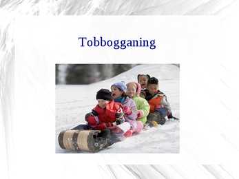
Tobbogganing What is it? Tobagganing is a winter sport where you use a sled to slide down a smooth hill. Breakneck speed down a high-banked icy bobsled run. How did it get started? The event was started long back. There was not much entertainment options left with the people. During winter, flowing from the hill would freeze. Most kids would spend hours skating down the hill The toboggan Originally an American Indian sled made of poles tied together with thongs. The modern version is usually built of thin, straight-grained boards of hickory, birch, or oak fastened together by light crosspieces. Metal or laminated wood.
Natural Zones and Flora. There are five distinguishable natural zones in Australia. In the very east there are wet forests (1.) that occupy the space between the Great Dividing Range and the eastern coast. Westward from the Great Dividing Range the wet forests give place to beautiful grasslands with some trees . These grasslands are called the savannas (2.). Farther west the trees disappear and the bushlands (3.) begin. The real desert (4.) occupies the centre of the Western Plateau. In the very southwest there are thin forests of evergreen trees (5.).
Ibiza Independed work Enelin Paistu LM08 Ibiza Ibiza is an island in the Mediterranean Sea 79km off the coast of the city of Valencia in Iberian Peninsula Spain. It is the third largest of the Balearic Islands, an autonomous community of Spain. With Formentera, it is one of the two Pine Islands or Pityuses. Its largest cities are Ibiza Town (Catalan:Vila d'Eivissa or simply Vila), Santa Eulària des Riu and Sant Antoni de Portmany. Eivissa is the official Catalan name (Catalan pronunciation:, locally. The name in
Multiple Choice Exercise Correct! Well done. Your score is 60%. 1. Jane is arriving on January 26 at 2 o'clock in the afternoon. 2. It snows here every year in December. We always go outside and play in the snow on Christmas day. 3. Michael is leaving on Friday at noon. 4. Frankie started working for her law firm in 1995. 5. Franklin began working on the project NO PREP yesterday. 6. Normally, on New Year's Eve, it's tradition to kiss the one you love at midnight. 7 Don't be ridiculous; there were no telephones in the seventeenth century! The telephone was invented in the 1870s. 8. The plane leaves NO PREP tomorrow morning at 8:00 AM. 9. The hills here are covered with wildflowers in early spring. 10. We met at the restaurant at 6:30 and stayed until 10:30. Ermo Altmäe 011PK Time Prepositions 2 Multiple Choice Exercise Correct! Well done. Your score is 14%. 1. She always gets up early in the morning, so she can make it to class in time. 2
Saaremaa Saaremaa biggest island in Estonia located in the Baltic Sea 2673 km2 populatin over 35000 ihabitants density 13 inhabitants/km2 16 municipalities- next year 14 The capital of Saaremaa is Kuressaare Saaremaa - an exciting island Saaremaa - the biggest island of Estonia is known as a good recreation place with unique nature and a lot of sights Saaremaa has retained its uniqueness due to its location and insulation Junipers, dolomite, windmills and the famous local home-brewed beer are considered the symbols of Saaremaa A lot of sights Among the numerous sights of Saaremaa, several are worth calling special attention to, e.g. Angla
- the evening - my birthday -lunchtime - December -Christmas Eve -night - The summer -new year eve -the weekend - 1998 -Christmas /Easter/new year There is/are Singular Plural + There's a piano + there are some glasses in the cupboard - There isn't a fridge - there aren't any pictures ? Is there a TV? ?are there any glasses? Yes, there is yes, there are. No, there isn't no, there aren't There was/there were + there was an old TV + there were only three guests - there wasn't a remote control -there weren't any more people ? was there a ghost?