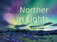
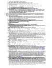
Norther n Lights Kaisa Kask Introduction 1. How and where Northern Lights appear? 2. How the Northern Lights got their colors? 3. Do the Northern Lights emit sound? How and where Northern Lights appear? • Charged particles collide with molecules • Generate a glow • The strongest auroras are quite bright • The aurora occurs above: altitudes of 80 km infrequently above 500 km normal altitudes 110 and 200 How the Lights got their colors? • Every gas creates a different color • neon lights: helium – pink/white neon - red/orange argon - lavender krypton - gray/green The colors of auroras • Determined by gases in the Earth’s atmosphere • Solar particles collide with different gases • Oxygen (300km) – a rare red aurora • Oxygen (100-300km) – yellow-to-green aurora Do the Northern Lights emit sound? • Subject of discussion • Proven that people can hear...
NORTHERN LIGHTS LIINA VIROLAINEN 12A CLASS KEILA KOOL NORTHERN LIGHTS Northern lights is a common name for the Aurora Borealis in the Northern Hemisphere. Where can we see the northern lights? The Northern Lights, as the name suggests, are especially related to the polar regions. They occur most frequently in a belt of radius 2500 km centered on the magnetic north pole. This so-called auroral zone extends over northern Scandinavia, Island, the southern tip of Greenland and continuing over northern Canada, Alaska and along the northern coast of Siberia. How often can you see the Northern Lights? In Troms and Finnmark, we can see the Northern Lights every other clear night, if not even more frequently. From southern Norway, only a few times a month while in central Europe hardly more than a few times a year and they have even been seen from the Mediterranean but only a few times each century. To the no...
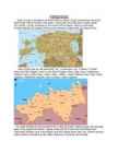
Estonia Where it is? Republic of Estonia is a state in the Baltic region of Northern Europe .It is bordered to the north by the Finland, to the west by the Baltic Sea, to the south by Latvia (343 km), and to the east by lake Peipus and Russia (338.6 km). Across the Baltic Sea lies Sweden in the west and Finland in the north. Towns Tallinn is the capital and the largest city of Estonia. It lies on the northern coast of Estonia, along the Gulf of Finland. There are 33 cities and several town-parish towns in the country. In total, there are 47 linna, with "linn" in English meaning both "cities" and "towns". More than 70% of the population lives in towns. History • Estonia was settled near the end of the last glacial era, beginning from around 8500 BC. Before the German invasions in the 13th century proto-Estonians of the Ancient Estonia worshipped the spirits of n...
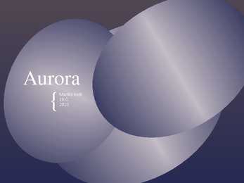
Aurora { Mariliis Kolk 10.C 2013 aka northern lights Aurora Borealis in the north Aurora Australis in the south flows of particles and magnetism mirrorlike images that occur at the same time General information result of collisions between gaseous particles in the Earth's atmosphere with charged particles released from the sun's atmosphere the earth's magnetic field is weaker at either pole and therefore some particles enter the earth's atmosphere and collide with gas particles Cause highaltitude oxygen: red most common yellowishgreen Appearance nitrogen: blue/purple northern/southern hemisphere Iceland, Norway, Canada, Alaska, Greenland no light pollution clear nights local midnight Where? When? Jupiter Saturn On other planets http:// www.youtube.com/watch?v=FcfW http://www.nort...
About Estonia Estonia, officially the Republic of Estonia is a country in Northern Europe. Estonia has land borders to the south with Latvia and to the east with Russia. It is separated from Finland in the north by the Gulf of Finland and from Sweden in the west by the Baltic Sea. Average elevation reaches only 50 meters and the country's highest peak is the Suur Munamägi in the southeast at 318 meters.Estonia boasts over 1,400 lakes. Most are very small, with the largest, Lake Peipus, (Peipsi in Estonian) being 3555 km². There are many rivers in the country. The largest are the Võhandu (162 km), Pärnu (144 km), and Põltsamaa (135 km). Estonia also boasts numerous bogs, and 3794 kilometers of coastline marked by numerous bays, straits, and inlets. The number of islands and islets is estimated at some 1,500. Two are large enough to constitute their own counties: Saaremaa and Hiiumaa. Estonia lies in the...
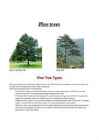
Pine trees Short Leaf Pine Tree Pine Tree Pine Tree Types Pines are among the most well-known coniferous trees in the world. They thrive in temperate mountainous regions, but can also survive in tropical spots in the northern hemisphere. Among the most popular types of Pine trees are: ·Scotch Pine: Commonly found in North America where it is commercially grown as a Christmas tree, the Scotch Pine is known for its beautiful bluish-green needles and full shape. ·Ponderosa Pine: Popular among landscapers, the large Ponderosa can grow up to 80 feet tall. Its pyramidal shape and long needles make it an excellent choice for a windbreaker on large properties. ·Bristlecone Pine: Known for its long life, the Bristlecone is among the shortest types of Pine trees. On ...
The Foundation of Estonia Estonia The history of Estonia The history of Estonia is a part of the history of Europe. Estonia was settled near the end of the last glacial era, beginning from around 8500 BC. Before the Germans invaded in the 13th century proto-Estonians of the Ancient Estonia worshipped the spirits of nature. Since the Northern Crusades Estonia became a battleground for centuries where Denmark, Germany, Russia, Sweden and Poland fought their many wars over controlling the important geographical position of the country as a gateway between East and West. Being conquered by Danes and Germans in 1227, Estonia was ruled initially by Denmark in the north, by the Livonian Order, an autonomous part of the Monastic state of the Teutonic Knights and Baltic German ecclesiastical states of the Holy Roman Empire. From 1418–1562 the whole of Estonia was part of the Livonian Confederation. A...
The UK & London The United Kingdom (or the UK) is a short way of saying the United Kingdom of Great Britain and Norther Ireland. The UK is situated north-west of the European continent between the Atlantic Ocean and the North Sea. The UK consists of England, Wales, Scotland and Northern Ireland. Its highest point is Ben Nevis in Scotland followed by Snowdon in Wales. The Severn is the longest river in the United Kingdom. Other important rivers are the Trent, the Mersey, the Tyne, etc. Lough Neagh which lies in the centre of Northern Ireland is thr UK's largest freshwater lake. The climate in the UK is variable. The weather changes so frequently that it is difficult to forecast. It is not unusual for people to complain that the weathermen were wrong. Fortunately there is no extreme weather conditions, it is never very cold or very hot. The first inhabitants were Iberians and Celts who sett...
Essee Great Britain or Britain (Welsh: Prydain Fawr, Scottish Gaelic: Breatainn Mhòr, Cornish: Breten Veur) is an island situated to the northwest of Continental Europe. It is the ninth largest island in the world, and the largest European island, as well as the largest of the British Isles. With a population of about 60.0 million people in mid-2009, it is the third most populous island in the world, after Java and Honsh. Great Britain is surrounded by over 1,000 smaller islands and islets. The island of Ireland lies to its west. Politically, Great Britain may also refer to the island itself together with a number of surrounding islands which comprise the territory of England, Scotland and Wales. All of the island is territory of the sovereign state of the United Kingdom of Great Britain and Northern Ireland, and most of the United Kingdom's territory is in Great Britain. Most of Eng...
Tibet Tibet is a plateau region in Asia, north of the Himalayas, and the home to the indigenous Tibetan people and some other ethnic groups. With an average elevation of 4,900 metres, it is the highest region on Earth and has in recent decades increasingly been referred to as the "Roof of the World". In the history of Tibet, it has been an independent country, divided into different countries, and a part of China each for a certain amount of time. Tibet was first unified under King Songtsän Gampo in the seventh century. A government nominally headed by the Dalai Lamas, a line of spiritual leaders, ruled a large portion of the Tibetan region at various times from the 1640s until 1950s. During most of this period, the Tibetan administration was subordinate to the Chinese empire of the Qing Dynasty. The 13th Dalai Lama proclaimed Tibet independent in 1913, but this declaration was not accepted b...
Inuit Culture, Traditions, and History Traditional Inuit way of life was influenced by the harsh climate and stark landscapes of the Arctic tundra from beliefs inspired by stories of the aurora to practicalities like homes made of snow. Inuit invented tools, gear, and methods to help them survive in this environment. Read on to learn more about traditional Inuit ways of life, and how Inuit culture has been changed over the past century. Geography Inuit communities are found in the Arctic, in the Northwest Territories, Labrador and Quebec in Canada, above tree line in Alaska (where people are called the Inupiat and Yupik), and in Russia (where people are called the Yupik people). In some areas, Inuit people are called "Eskimos" however many Inuit find this term offensive. The word "Inuit" means "the people" in the Inuktitut language. Inuit Homes In the tundra, where Inuit communities are found, there are not many building materials. No...
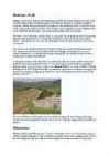
Hadrian's Wall Hadrian's Wall was a stone and turf fortification built by the Roman Empire across the width of Great Britain to prevent military raids by the tribes of Scotland to the north, to improve economic stability and provide peaceful conditions in the Roman province of Britannia to the south, to physically mark the frontier of the Empire, and to separate the unruly Selgovae tribe in the north from the Brigantes in the south and discourage them from uniting. The name is also sometimes used jocularly as a synonym for the border between Scotland and England, although for most of its length the wall follows a line well south of the modern border -- and neither the Scoti tribe nor the English lived in Britain at the time of the wall's construction. The wall was the northern border of the Empire in Britain for much of the Roman Empire's rule, and also the most heavily fortified border in the Empire. In addition to its use as a milit...
Territory and landscape Canada is one of the largest countries in the world. It covers nearly 4 million square miles. It is dividend into ten provinces( British Columbia, Manitoba, New Brunswick, Alberta, Nova Scotia, Ontario, Prince Edward Island, Quebec, Saskatchewan, Newfoundland ) along with two territories( the Yukon, the Northwest territories ). The capital city is Ottawa. Canada is a country rich in forests. It borders in the south with The United States and it's surrounded in the west by the Pacific Ocean, in the east by the Atlantic Ocean and above by many smaller bays, but is also borderedd with Alaska in the north-west. To the north of Canada is the broad Canadian Shield, an area of rock scoured clean by the last ice age, thinly soiled, rich in minerals, and dotted with lakes and rivers. Canada by far has more lakes than any other country and has ...
Joanne Kathleen Rowling Joanne Kathleen Rowling was born in July 1965 at Ingland. Joanne left Chepstow for Exeter University, where she earned a French and Classics degree, her course including one year in Paris. As a postgraduate she moved to London and worked as a researcher at Amnesty International among other jobs. She started writing the Harry Potter series during a delayed Manchester to London King's Cross train journey, and during the next five years, outlined the plots for each book and began writing the first novel. Jo then moved to northern Portugal, where she taught English as a foreign language. She married in October 1992 and gave birth to a daughter Jessica in 1993. When the marriage ended, she and Jessica returned to the UK to live in Edinburgh. Her books She got a idea to write about it is in King Cross train station. Harry Potter is a series of seven fantasy novels written by British autho...
Old Tallinn Old Town, a medieval walled city filled with old buildings and fortifications. The sheltered bay and the easily defended Toompea Hill made it a natural place to settle. Sometime about 1050 A.D. a fortress was built atop the hill, the first of many. In 1219 the Danes showed up as part of the Northern Crusade to subjugate the Baltics and convert the local pagans to Christianity whether they wanted to or not. The Danes improved the fortifications and expanded the town, which became part of the Hanseatic League, a trading organization of a hundred northern cities. The Danes sold Tallinn to the Livonan Order, a branch of the Teutonic Knights, in 1346. The Swedes came next in 1561. Tallinn weathered plague and the Great Northern War and became part of Russia in 1710. In 1918, Estonia declared independence from Russia and fought a bitter war against Bolshevik Russia. Independence didn’t last long, ...
The United States of America (The U.S.A) Geography The main part of the United states extends from the Atlantic Ocean in the east to the Pacific Ocean in the west. It covers the middle of the North American continent. This area is called ,,the continental United states". The continental United States is bounded to the North by Canada and to the South by Mexico. The border with Canada is often called ,,the longest unguarded border in the world". The United States and Canada are good friends and they have very few problems in managing the border. The borded with Mexico is different. Immigrants are constantly crossing the border illegally. Every day about 2,000 of them are captured and sent back, but may others get through. There are also two states that are not connected to the continental United States. They are Alaska and Hawaii. There are two mountain ranges in ...
Estonia officially the Republic of Estonia, is a country in the Baltic region of Northern Europe. It is bordered to the north by the Gulf of Finland, to the west by the Baltic Sea, to the south by Latvia and to the east by Russia. Across the Baltic Sea lies Sweden in the west and Finland in the north. The territory of Estonia covers 45,227 km2, and is influenced by a humid continental climate. Estonia is a democratic parliamentary republic divided into fifteen counties, with its capital and largest city beingTallinn. With a population of 1.3 million, it is one of the least-populous member states of the European Union. The Estonians are a Finnic people, and the official language, Estonian, is a Finno-Ugric language closely related to Finnish The history of Estonia is a part of the history of Europe. Estonia was settled near the end of the last glacial era, beginning from around 8500 BC. Before the Germans invaded in the 13th century pro...
TALLINN TOWN HALL Britt Viks Haapsalu Gümnaasium 2011 HISTORY Tallinn Town Hall was very important building in the Tallinn Old Town. There were many events like : trading or killings. It was built in 13th century. In the past it was city goverment. It is the only gothic style building in the Northen Europe. NOW Now is the building concert hall and a musem, what is very valued. Every Estonian should know about Christmas in the Tallinn Town Hall. ( There is biggest Christmas Tree in the Estonia ) INTERESTING There is round stone, what put in place all the distances. City Hall Tower, the Old Thomas curious tip of the city of Tallinn is one of the symbols. QUESTIONS What makes it different ? Where is the Tallinn Town (Compared to other buildings Hal...
My home town of Valga Guide to Valga town ancient and modern Valga is the southern-most town in Estonia and despite its small size, the town straddles two countries. So it has two languages, two currencies and two cultures. Valga also has a rich history and a versatile cultural scene. Valga town is a pearl waiting to be discovered. In the south, Estonia shares a border with Latvia and here Valga town is split in half, the northern side, "Valga", belongs to Estonia and "Valka", on the southern side, belongs to Latvia. For years, this created a complicated situation where members of one family, even living on the same street, may have had different citizenships and had to go through customs and border guards in order to visit each other. Fortunately, after both countries joined the Schengen zone, border points were removed and Valga-Valka is fast overcoming the separation issues. Two different c...
Republic of Chile Republic of Chile is a country in South America occupying a long and narrow coastal strip wedged between the Andes mountains and the Pacific Ocean. Chile's unusual, ribbon-like shape -- 4,300 kilometres long and on average 175 kilometres wide -- has given it a hugely varied climate, ranging from the world's driest desert -- the Atacama -- in the north, through a Mediterranean climate in the centre, to a snow-prone Alpine climate in the south, with glaciers, fjords and lakes. The Pacific forms the country's entire western border, with a coastline that stretches over 6,435 kilometres. Chile expanded in the late 19th century, when it incorporated its northern and southern regions. Southern Chile is rich in forests and grazing lands and features a string of volcanoes and lakes. The southern coast is a labyrinth of fjords, inlets, canals, twisting peninsulas, and islands. Prior to the com...
... Gümnaasium English Project Sights of Estonia Student: .............................. Class: 6 ... Teacher: ............... Harjumaa 2011 1 1. Steamer-icebreaker Suur Tõll The ship was built in 1914 in Stettin (Szczecin) by Vulkan-Werke A. G. Suur Tll is the only pre-war steam ship of the Republic of Estonia remained up to now and, at the same time, the biggest icebreaker in the world preserved through two world wars. All the 3 original steam engines as well as most of the original arrangement of space and late Jugendstil interior of the officers' rooms are preserved. In 1914 the first home port of the ship was Tallinn. The ship ensured a regular winter sea navigation for Tallinn up to the end of the independency period. 2. The Tallinn Song Festival Grounds The Tallinn Song Stage was built in 1959 for arranging the Song Festivals....
nature What is nature? Nature, in broadest sense, is material world- all the universum. In smaller sense, nature is part of world, which is not influenced by humen activity. Where come from word nature? The word nature is derived from the Latin word natura, or "essential qualities, innate disposition", and in ancient times, literally meant "birth". Natura was a Latin translation of the Greek word physis which originally related to the intrinsic characteristics that plants, animals, and other features of the world develop of their own accord. Most Beautiful Places Of The World We quite often see and read about manmade wonders of the world but have we ever thought about natural wonders surrounding us. Top ten natural wonders of the world is very hard to get 100% consensus on because there are so many wonderful places on Earth. Grand Canyon Yosemite Valley Great Barrier Reef Aurora Borealis or Northern Lights ...
Inglise keele kontrolltöö 7. klassile Õpik: I love English 4 Kokkuvõte aasta jooksul õpitust. Koostaja: Gea Gutmann Viljandi Maagümnaasium Juhendaja: Toomas Rähn Final Test Form 7 Name................. 1. Use the right tense. (15 p) 1) Look! She....................................(carry) a heavy bag. 2) Mrs. Brown...................................(play) the piano at the concert next week. 3) Mary is a good girl. My mother............................(meet) her every day since she and her father moved here. 4) Yesterday at two o`clock Tom ..............................(sing) and his sister ........................... (draw) a pictuture in the living room. 5) The wind ........................(be) very strong some days ago. 6) Where are the children? They .........................................
Project ESTONIA MAP OF ESTONIA Southern Viljandimaa The southern part of Viljandi county catches the eye with its sublime scenery. The area today lies in the very heart of the historical Mulgimaa the home of hills, deep valleys and lakes brought together by a beauty spot Halliste primeval valley. According to several folk tales, it is also in these valleys, woods and bogs that Old Nick found refuge.The great variety displayed in the nature is also reflected in the local cultural heritage. At the beginning of the 19th century growing linen spread and became the basis of the legendary wealth of Mulgi farms. The ancient barn-dwellings and decaying manor houses are the mute witnesses of those times. The riches and cultural heritage of Mulgimaa owe to the diligence and tenacity of the local people. Village handicraftsmen and masters have always been honoured. Mulgikapsad (stewed sauerkraut with barley gro...
Ice hockey Rauno leppik 7.a Ice Hockey Ice hockey is a team sport played on ice. It's a fastpaced and physical sport. Ice hockey is a most popular in areas that are sufficiently cold for natural reliable seasonal ice cover such as Canada, the northern United States, Scandinavia and Russia. History European immigrants brought various versions of hockey: like games to Canada, such as the Irish sport of hurling, the closely related Scottish sport of shinty, and versions of field hockey played in England. Where necessary, these seem to have been adapted for icy conditions; for example, a colonial Williamsburg newspaper records hockey being played in a snow storm in Virginia. Early paintings show "shinney", an early form of hockey with no standard rules, being played in Nova Scotia in Canada. ...
The United Kingdom is an island located on the North-Western coast of continental Europe, while the United States of America is situated mostly in central North America where forty-eight states of it's 50 lie, with the exception of Alaska and Hawaii. The population in the UK is about 62 million people whilst in the US that number is about 300 million, making it the third largest country in the world by population. The languages in Britan and America are varieties of english and therefor very similar. The capital of England is London and the capital of America is Wachington D.C., formally the District of Columbia. Whilst the capital of Great Britain is also it's largest city, it is not so in the United States, where the biggest city is New York with a population of over 8 million and about 20 million if you count the metropolitan area (people living in the immediate surrounding area outside of t...
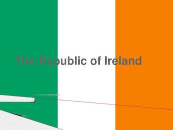
The Republic of Ireland General overview Territory: 27,097 sq miles Population: 4 million Capital: Dublin Patron Saint: St Patrick The second largest of the British Isles 60 million people outside Ireland claim Irish ancestry Landscape and climate Ireland is low in the middle and high at its edges. Not very high mountains; highest is Carrantuohill (1,040 m) in the southwest At Moher, you can look 200m straight down into the sea Green fields, full of flowers, wide and empty beaches All landscape types are represented Climate is damp Ireland is one of the wettest countries in Europe History St Patrick converted the Irish to Christianity In mid16th century Henry VIII declared himself King of Ireland and broke away from the Roman Catholic Church In 1601, Queen Elizabeth I defeated the Irish army at the battle of Kinsale and the land was dominated by Protestants The Act of Union in 1801 made England and Ireland one country w...
Canada Canada is a country occupying most of northern North America, extending from the Atlantic Ocean in the east to the Pacific Ocean in the west and northward into the Arctic Ocean. It is the world's second largest country by total area, and shares land borders with the United States to the south and northwest. Canada is a federation composed of ten provinces and three territories; in turn, these may be grouped into regions. Western Canada consists of British Columbia and the three Prairie provinces (Alberta, Saskatchewan, and Manitoba). Central Canada consists of Quebec and Ontario. Atlantic Canada consists of the three Maritime provinces (New Brunswick, Prince Edward Island, and Nova Scotia), along with Newfoundland and Labrador. Eastern Canada refers to Central Canada and Atlantic Canada together. Three territories (Yukon, Northwest Territories, and Nunavut) make up Northern Canada. ...
1.Which five areas does Highland Britain include? 1)Scotland 2)Wales 3)The Cornwall Peninsula 4)The Lake District 5)The Pennines 2.What is the highest top in Wales Snowdon 1,085m Scotland Ben Nevis 1,343m England Scafell Pike 978m How high is the highest mountain in the UK? Ben Nevis, 1,343m 3.Describe the relief of Scotland. Scotland is quite mountainous and there is also situated the highest peak in the UK, Ben Nevis. The Scottish Highlands cover the northern part of the country. Here The Northwest Highlands have rocky lunar landscape. South of Scotland is mostly covered with the Grampian Mountains which forms with some other mountains a huge mountain mass. The Central Lowland lie south of the Scottish Highlands. This region is a gently rolling plain. It has best farmland, and richest coal deposits. The Southern Uplands rise gently south of the Central Lowlands. This is a region of rounded, rolling hills. 4.What are the possibil...
Tallinn Old Town It was built up from the 13th to 16th centuries, when Tallinn was a thriving member of the Hanseatic trade league. It is built on a big hill and is surrounded with big walls. There is a lot of medieval style houses and inns, courtyards, churches and museums and a lot more. Many have described Tallinn Old Town as mystic and addictive. Unlike other capital cities in Europe, Tallinn has managed to preserve the completeness and structure of it's medieval and Hanseatic origin. Even after 7 centuries, Town Hall Square still remains as the social heart of the city and is hosting many concerts and fairs. Town Hall on Town Hall square is the only intact Gothic town hall in Northern Europe, now operates as a museum and concert hall.On top of the Town Hall tower, you will see a beloved guard of Tallinn Old Town Vana Toomas.One of the most impressive churches in Old Town is 15th and 16th century, St. Olaf's Church (Oleviste) wit...
Ned Kelly Ursula 11. kl · Edward (Ned) Kelly, bushranger, was born in June 1855 at Beveridge, Victoria, the eldest son of John (Red) Kelly and his wife Ellen. His father was born in Tipperary, Ireland, in 1820 and sentenced in 1841 to seven years' transportation for stealing two pigs. He arrived in Van Diemen's Land in 1842. When his sentence expired in 1848 he went to the Port Phillip District, where on 18 November 1850 he married Ellen, the eighteen-year-old daughter of James and Mary Quinn; they had five daughters and three sons. · · Ned attended school at Avenel until his father died on 27 December 1866. Left indigent, the widow and children moved to a hut at Eleven Mile Creek, about half-way between Greta and Glenrowan in northern Victoria, where Ned became the main breadwinner, taking jobs as a timber cutter and rural worker - ringbarking, breaking in horses, mustering cattle and fencing. · Kelly, 14...
Australia Australia is the only country in the world that covers an entire continent, yet also the smallest and the driest of all the continents. It's almost the same size as continental USA, being the sixth largest country in the world. It's also the oldest some of the rocks are more than 3,000 million years old. Australia is often called `Down Under', because it lies in the Southern Hemisphere. As a result, its seasons are the opposite of ours. Australia, Tasmania and a number of smaller islands form the Commonwealth of Australia. Because of the country's great size, the climate in Australia ranges from tropical regions of the Northern Territory to the cool temperate conditions in the southeast and Tasmania, where it often snows in winter. In the north, half the year is `wet' and half is `dry'. From November to April heavy rain fills the rivers and makes enormous lakes where thousands of birds come for the summer. From May to Octobe...
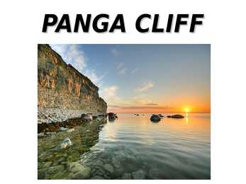
PANGA CLIFF The Panga cliff is located on the northern shore of Saaremaa, at the end of the Kuressaare - Võhma road, close to Panga village. It is the highest of the Saaremaa and Muhu cliffs, reaching to a maximum of 21.3 meters. The entire cliff is approximately 2.5 kilometers long. Standing at the tip of the cliff, one can clearly see another half-circular cliff under water. This is especially noticeable during storms, when the waves break against the underwater rocks, while the inside of the half-circle is calm. During bird migrations in the spring and fall, this half-circular lagoon is a favorite stopover point for storks on their long trip to and from Egypt, where most of them spend the winter. Sometimes there are well over a hundred storks, as well as other waterbirds, resting in the calm waters of the lagoon. Folk tradition ties Panga cliff as a place of worship and sacrifice for the ancient Saarlanders. It is known that unti...
Estonia Estonia is a small country in Northern Europe with an area of about 45 000 sq km. As a part of the East-European Plain, the country has a rather flat surface. The highest and most diverse region in Estonia is in the south-eastern part of the country. At 318 metres, Suur Munamägi is not only the highest point in Estonia, but of all the Baltic countries. There are about 1500 islands in Estonia, the biggest of which being Saaremaa and Hiiumaa. Sixty-four species of mammals have been recorded in Estonia, three of them have been introduced: the racoon dog, the American mink and the muskrat. A couple of species have been re-introduced The European beaver, who was hunted to extinction by the end of the 19th century. A vital population of them now exists in Estonia once again. Another re- introduced species is the red deer. An attempt has been made in Estonia in recent years to disperse the p...
· Jägala Waterfall (height 8 m) is one of the highest and fastest flowing. Over thousands of years the falling water has worn out the edge of the limestone banks and as a result a steep-sided valley about 300 m long and 12-14 m deep has been created. The oldest written information about a water mill (the beginning of the 13th century) derives from this place. The best impression of the mightiness of the waterfall can be obtained in the period of high waters in spring and autumn. · Narva Stronghold is the oldest and biggest stronghold in Estonia (built in 13- 17th century) creating with the Ivangorod Stronghold on the opposite shore of the River Narva a unique architectural ensemble in Northern Europe. Three wings of the stronghold and the Tower of Tall Hermann are open to visitors. The historical interiors in the West and North wings have been restored. In the five halls of the stronghol...
Anglo-Saxon period Celts-came from Germany,2000-1200BC began to migrate to Britain,spoke Celtic language,were known as Britons,lived in small villages,round wooden huts-mainly farmers-no towns,organised in tribes with a king/queen as a leader,intertribal wars were very common,the Ancient Britons:one of the Celtic tribes living in Britain 4thBC,believed in different gods,governed by a class of priests-druids who had great power. Romans in Britain:55BC came to conquer Britain(Julius Caesar),brought their own civilization,taught Britons to build roads,bridges,houses,baths,temples,protected Britain for several hundred years,4thBC Romans left Britain,43AD Queen Boadicea of Iceni tribe lost their battle with Romans. Who were the next invaders and where did they come from? Anglo-Saxons came from northern Germany,Denmark and northern Holland. What was their lifestyle like?Anglo-Saxons liked fighting,drinking,gambling,life expectancy not very lo...
Tallinn English College Topic Great Britain 2007 1. Introduction The official name of Great Britain is `the United Kingdom of Great Britain and Northern Ireland (or short United Kingdom)' The population is about 60.4 million. The capital is London. Other biggest cities include Birmingham, Bristol, Portsmouth, Glasgow and Swansea. English is the main language of Great Britain, but Welsh is officially recognized in Wales and Gaelic in Scotland. 2. Geographical position The British Isles is the geographical term for a group of about 5000 islands off the coast of mainland Europe. The largest island is Great Britain, which is also the largest island in Europe. It consists of England, Wales and Scotland. The next largest island is Ireland, which is made up of Northern Ireland and the Irish Republic. Britain and Northern Island together form the United Kingdom. When referring to Britain ...
Estonians... Estonia is quite a northern country and therefore Estonians may seem a bit peculiar to ones from south, but don't be scared, they will not eat you (alive). Estonians are quite tranquilly and bottled up people - they might love or hate you and if you're not an expert will not make a difference as they didn't care at all. Rarely tend they to kiss or hug each other unless their beloved ones. So if they nevertheless do it then there's a great chance you're dealing with some non- Estonians. But there's no reason for worrying- if a person is from a region where that kind of over-loving-behaviour is common and he or she practices it anyway then a bathetic Estonian will just bear it and play along. In case of visiting like in many other European countries in Estonia it's also polite to bring some presents with you, usually a box of chocolate or something like that will do the trick. To greet "Tere!" is the word you won't get wron...
1. What are the capitals of the 4 constituent countries? England- London; Northen Ireland- Belfast; Scotland- Edinburgh; Wales- Cardiff 2. Order the invaders in correct chronological order: Anglo-Saxons, Normans, Romans, Celts. Romans Anglusaxons , Norman 3. How did the Celts influence Britain? Language. Wars. Engand and Scotland eventually became 1 contry 4. How many people approximately speak English? Approximately 600 million 5. Who (which tribes) gave the base of the English language?Germanic tribes- Anglo-Saxons. 6. Describe Wales.- Wales is a mountainous country on the western side of Great Britain. The national game of Wales is Rugby. Flag- Red dragon on a green and white field. They have their own language Cymraeg ( Welsh) . Anthem- Land Of My Fathers. Official animal- Dragon. There used to be a lot of coalmines. 7. What are the symbols of the 4 constit...
Tallinn is a small port town in which the population is 371 000 people, and the area is only 159,2 km².( square kilometers). Tallinn, the capital of Estonia, is named after taani linnus, which means Danish castle. The Castle in question was built by King Waldemar of Denmark in the 13th century. The settlement quickly developed itself into a busy port. -The Old Town In medieval age Tallinn was called Reval and it was as big as the Tallinns Old Town is now. Uniqueness of Tallinn is that it is one of very few European cities, where the historical lay-out is kept in it's original form , and has a lot of monuments of that time. Thanks to that in 1997 Old Tallinn has been included in the list of a world heritage of UNESCO. -The Raekoja Square The Raekoja Square is used for senturies like market and fair square, here took place many festivals, and criminals were executed. In summer on Raekoja Square many open air conserts ...
Oliver Niinas Special Reports TTÜ TK Northern lights 1. What changes Sweden´s brought with the quiet revolution? the country was demoted from being the world's fourth-richest in 1970 to 14th-richest in 1993, when the average Swede was poorer than the average Briton or Italian. The two decades from 1990 were a period of recovery: GDP growth between 1993 and 2010 averaged 2.7% a year and productivity 2.1% a year, compared with 1.9% and 1% respectively for the main 15 EU countries. 2. Nordic country´s has joined with the same direction, how to they differ from each other? Denmark has one of the most liberal labour markets in Europe. It also allows parents to send children to private schools at public expense and make up the difference in cost with their own money. Finland is harnessing the skills of venture capitalists and angel investors to promote innovation and entrepreneurship. Oil-rich Norw...
Harjumaa Harju County is situated in northern Estonia. Harju County, bordered by the south- westcounty, Rapla County in the south, south-east and east Järva county Lääne- Viru county. County, bounded on the north Gulf of Finland. Harju is composed of many islands, the largest of these is the Women's Island and the islands Pakri. Harju county has six self-governing city, a municipal city, 2 towns, 31 small towns and 395 villages. Harju county has 21 bigger cities Loksa, Nissi, Vasalemma, Paldiski, Kernu, Keila, Saue, Harku, Saku, Tallinn, Viimsi, Ostrava, Rae, Kose Kõue, Raasiku, Jõelähtme, Maardu, Anja, Kuusalu, Loksa, Aegviidu. 34 rivers flowing into the sea within the county and other watercourses, the drainage basin is the largest and tallest Jägala, Keila and the Pirita River and White River. Harjumaa Ülemiste Lake is the largest, and the Kahala Harku lake, too. Tallinn's surface w...
Population 1. Size, its changes 2. Distribution 3. Towns 4. Ethnic makeup 5. Age breakdown 6. Religion(s) 1. Size. 1 July 2006 population estimates by UK National Statistics: % (mid- Part Population (mid-2006) 2006) England 50,762,900 83.8 Scotland 5,116,900 8.4 Wales 2,965,900 4.9 Northern Ireland 1,741,600 2.9 United Kingdom 60,587,300 100 Although Britain is quite small in terms of land area (245,000 sq km), it has a large population of nearly 61 million, which ranks the 21st in the world (Britain is the 21st most populous state in the world) and the third largest in the European Union. The size of population is chan...
Symbols of Estonia Estonian coat of arms The Estonian coat-of-arms has ancient roots and resembles both that of Denmark and of England. The three blue leopard-like creatures on a gold background were first used in 1219 as part of the coat-of-arms of the city of Tallinn and, later in history, of the Estonian province. In 1925, what is called the three lion coat-of-arms finally became the national coat-of-arms. National flower The campaign to choose a national flower for Estonia was organized by The Estonian Wildlife Protection Society in 1967-1968 where the ornamental Blue Cornflower was the favourite because of its popularity and decorative appearance, because of this Blue Cornflower was selected as the National Flower of Estonia. National bird The barn swallow, the national bird, is a characteristic guest of Estonian homes. Its call can be heard from practically every eave or barn rafter in t...
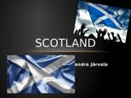
SCOTLAND Sandra Järvala GEOGRAPHY & POPULATION · Scotland is a country that is part of the United Kingdom and coers the northern third of the Island of Great Britain. · The Scotland capital city is Edinburgh. MAJOR CITIES · The largest city is Glasgow. Glasgow has a population of 598,830. The city has an area of 175.5 km ². · Aberdeen, Dundee, Paisley, East Kilbride and Livingston are are also large cities. · There is a Glasgow bus tours for tourists SCOTLAND FLAG · The Flag of Scotland, also known as Saint Andrew's Cross or the Saltire, is the national flag of Scotland. · Scottish flag is blue · On the flag is a white X-shaped cross. NATIONAL SYMBOLS · The national flower of Scotland is the thistle. · Scotland's national animal is the unicorn. · The Scots Pine is the national tree of Scotland. · Scotland's national bird is the golden eagle. HERALDRY · The Royal Arms of Scotland is a coat of arms symbolising S...
1. Fat Margareta - 16. Cent. Tallinn's most impressive defensive structures, the Great Coastal Gate (Suur Rannavärav) and Fat Margaret's Tower. They were built not only to defend the city from the seaward side of town, but also to impress any visitors arriving via the harbour. Fat Margareta used to be a prison. It is a town wall's building. Now it's home to the Estonian Maritime Museum, which provides a detailed look at the nation's seafaring past. 2. The Great Coastal Gate - with the Viru Gates, are the last of six gates that controlled access to the town in Medieval times. 3. Kolm Õde - a hotel. In 2003, three of Tallinn's splendid merchant houses, built in 1362, were renovated and united to create The Three Sisters, which now offers modern amenities with great design and a backdrop of medieval history. 4. Oleviste church baptism. Believed to have been built in the 12th century a...
Geography The name Australia means ,,southland". It is both a country and a continent, with an area of 7,617,930 square kilometres and it is also an island, separated from Asia by the Arafura and Timor seas. But Australia is also surrounded by the Indian and Pacific oceans. The Great Barrier Reef is the world's largest coral reef. It lies off the north-eastern coast and extends for over 2000 kilometres. The famous mountain range in the eastern part of Australia is the Great Diving Range and it's highest peak is Mount Kasciusco's 2230m. In the continental part, there are the Macdonnell ranges. Other smaller mountain ranges are the Musgrave Mountains, the Hammessley Mountains and the Darling Mountains. The continental part of Australia is mostly covered with deserts and these deserts are the Great Sandy Desert in the north-western part, the Great Victoria dessert in the southern part and Gibson desert and the Simpson desert. The Murr...
Country Studies The United Kingdom Test revision questions Form 11 1. What are the capitals of the 4 constituent countries? England London; Wales Cardiff; N-Ireland Belfast; Scotland - Edinburgh 2. Order the invaders in correct chronological order: Anglo-Saxons, Normans, Romans, Celts, Vikings. Celts > Romans > Anglo-Saxons > Vikings > Normans 3. How did the Celts influence Britain? The Celts were in Britain long before the English language existed. Celtic influence on English is minimal. There are more Amerindian words in English than Celtic ones. 4. How many people approximately speak English? 300million as mother tongue, 470million as 2nd language. 5. Who (which tribes) gave the base of the English language? Anglo-Saxons 6. Describe Wales. Part of the United Kingdom and the island of Great Britain, population: 3,064,000, Wales has a distinctive culture including its...
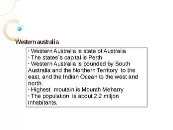
Western australia § Western Australia is state of Australia § The states´s capital is Perth § Western Australia is bounded by South Australia and the Northern Territory to the east, and the Indian Ocean to the west and north. § Highest moutain is Mounth Meharry § The population is about 2,2 miljon inhabitants. History Australian Aboriginal were the original inhabitants of Australia (60000 years ago). The first European visiter was Dutch explorer Dirk Hartog in 1616. On 1 January 1901, Western Australia joined the other Australia states. 1890 the population started to grow due to discovering gold. Coat of arms Flag Australian aboriginal culture According to Australian Aboriginal culture belief, spirit ancestors breathe life and energy into traditional dance, song and design and play a crucial role. Australian Aboriginal culture is widely seen as one of th...
Australia Australia is the world driest continent. More than two-thirds of country is desert or dry bushland. The climate is tensely hot. Australia is relatively flat country with mountainous only in the eastern regions. Most Australians live in the southern part of the country, where winters are wild and the summers are sunny and warm. The Great Barrier Reef is Chain of 500 island and coral reefs 2000 km long, near the coast of the north-east Queensland. It is one of the natural wonders of the world. There are some 150 million sheep in Australia. This is one-fifth of the total number of sheep in the world. Dingers are wild dogs of the outback, believed to have been brought to Australia by the Aboriginats tohusand of years ago. They are expert hunters. In the hot climate of north Australia, most houses are built with verandas which provide shade. The country is divided into six self-governing sta...