Leidsid 33 sarnast õppematerjali, mis on seotud failiga "Tennessee". Need materjalid aitavad sul teemat sügavamalt mõista.
tennessee, record, west, land, river, south, square, miles, lowest, major, states, became, spanish, explorer, while, known, first, official, different, regions, stripe, hanging, iris, areas, highest, feet, mississippi, mountain, volunteer, during, battle, religion, located, southern, join, memphis, captain, juan, traveling, inland, carolina, settledTallinn English College Topic The United States of America Tallinn 2007 1. Introduction The United States of America's territory is over 3.7 million square miles (over 9.6 million km²) and population more than 300 million people. The capital city is Washington D.C. Although the United States has no official language at the federal level, English is the de facto national language. English is the most common language for daily interaction among both native and non-native speakers. Spanish is the second language. The largest city is the New York City. The Government is Federal constitutional republic and the president is George W. Bush. 2
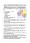
Tabasalu ühisgümnaasium Robin Nurk Tennessee presentation Information : Wikipedia Google Tabasalu 2012 Geographical location and features. Tennessee is located in the Southeastern United States. Tennessee is bordered by Kentucky and Virginia to the north, North Carolina to the east, Georgia, Alabama, and Mississippi to the south, and Arkansas and Missouri to the west. Tennessee's capital and second largest city is Nashville, which has a population of 626,144 people. Memphis is the state's largest city, with a population of 670,902 people. The state of Tennessee is geographically and constitutionally divided into three Grand Divisions: East Tennessee, Middle Tennessee, and West Tennessee. East tennessee West Tennessee Middle Tennessee
Tallinn English College Topic The United States of America Form Tallinn 2005 Introduction The United States of America is a very big country. Its territory is about 9.4 million square kilometres and its population is more than 260 million people, 12% of them are the Afro-Americans. It is the world's third-largest country by size and by population. The population density is about 27 people per square kilometre. Most of the people live in towns. There are 50 states in America. The biggest of the state is Texas, next by size are California, Alaska and Montana. Six states - Maine, Vermont, New Hampshire, Connecticut ,Rhode Island and Massachusetts are called New England
(www.ahdictionary.com). How did it get its name? It is difficult to say when the term submarine sandwich was first used for these types of large sandwiches. Although it is quite obvious that the sandwich got its name because of its long shape that resembles submarines, there are several myths around the origin of the term. The first theory is that at the beginning of World War II a sandwich was specifically created in a restaurant in Scollay Square in Boston to appeal to the mean serving at Charlestown Navy Yard. Because it resembled a submarine for its shape, people began to call them “submarine sandwiches”. According to another version, the sandwich was created during World War II by an Italian shopkeeper named Benedetto Capaldo in New London, CT. When the navy servicemen from the submarine base in the town of Groton across the river began ordering 500 sandwiches a day, the sandwich became irrevocably associated with submarines.
Relief The country naturally presents a tremendous variety in physical features. The highest peak of US is Mt. McKinley in Alaska at ~6000 metrs, while part of Death Valley in California is 89 metres below sea level. At the western edge of the Atlantic coast plain, are almost unbroken mountains, stretching from the Maine into Alabama, called the Appalachian Mountains. These mountains contain coal and iron. The heart of the U.S is a vas plain named interior plains and are divided into two major parts: the wetter, eastern part is called the Central Plains and the western part the Great Plains, both with very good soil. To the west of the Great Plains is the Cordillera. It is a region of tremendous variety, which can be subdivided into various other regions. On the eastern border the Rocky Mountains, a high, discontinuous mountains stretching from Alaska down to Mexico. The western edge of the Cordillera is described by high mountains. The most important
Topic The United States of America The U.S.A. is situated in the central part of the North American continent. The area of the U.S.A. is over nine million square kilometres. Its western coast is washed by Pacific Ocean and its eastern coast by the Atlantic ocean and the Gulf of Mexico. The continental United States is bounded to the North by Canada and to the South by Mexico. There are two mountain ranges in the continental United States: the Appalachians in the east and the Rockies in the west. In the very middle of the continent is the Mississippi river. The five Great lakes, between the U.S.A. and Canada, are joined together by short rivers or canals. They are connected with the Atlantic Ocean by the St. Lawrence River, and with the Hudson River by a canal. In the west of the U.S.A. there is another big lake called the Great Salt Lake.
mountain peaks. There are two big mountain ranges, one of them is the Rocky Mountains and the other is The Appalachian Mountains. The Capital of The USA is Washington D.C. Other big and famous cities are New York, Los Angeles, Houston, Chicago and Las Vegas. The national anthem of the United States is "The Star-Spangled Banner", with lyrics written in 1814 by Francis Scott Key. There are 6 time zones. From east to west they are: Eastern Standard Time, which is 5 hours behind Greenwich Time, Central Standard Time, Mountain Standard Time, which is 7 hours behind Greenwich Time, Pacific Standard Time. Alaska and Hawaii have their own time zones: Alaska Standard Time and Hawaii Standard Time. Geographical Position The USA lies in the Northern Hemisphere in North America. It covers a big part of the continent and is also the third largest country in the world. The country consists of 50 states, but two of them
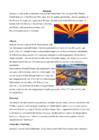
Alaska is separated by Canada and Hawaii lies in the Pacific Ocean. America shares borders with Canada, Mexico and Russia. According to different sources American landmass is from 9,522,055 km2 to 9,826,630 km2 which makes it the third or fourth largest country in the world. America is surrounded by three oceans Pacific Ocean, Atlantic Ocean and Arctic Ocean. It's also bounded with Gulf of Mexico and Bering Strait. The highest point in America is Mount McKinley (6,194 m) in Alaska. The lowest point is Death Valley which lies 86 metres below sea level. The Great Basin Desert is the largest desert in America. Missouri river is the longest river in the States. The largest lake is Lake Superior. Lake Superior Death Valley Nature There are very many species in the States. There are about 17 000 types of trees (larger plants) in the mainland and Alaska. Over 1,800 species of flowering plants are found in Hawaii
Introduction The United States of America is a very big country. Its territory is about 9.4 million square kilometres and its population is more than 260 million people, 12% of them are the Afro-Americans. It is the world's third-largest country by size and by population. The population density is about 27 people per square kilometre. Most of the people live in towns. There are 50 states in America. The biggest of the state is Texas, next by size are California, Alaska and Montana. Six states - Maine, Vermont, New Hampshire, Connecticut ,Rhode Island and Massachusetts are called New England. They are all small states in the U.S. that lie in the north-east. The first colony of immigrants settled down in Virginia, in the eastern part of the U.S.A.
USA ajaloo konspekt (algus-Mayflower Compact) 1. Name the regions of the USA New England, Middle Atlantic, South, Midwest, Southwest, West. 2. Name the states that make up each region. NE: Maine, New Hampshire, Vermont, Massachutsess, Rhode Island, Connecticut. MA: New York, Pennsylvania, New Jersey, Maryland, Delaware. S: Virginia, North Carolina, South Carolina, Georgia, Florida, Alabama, Mississippi, Louisiana, Missouri, Arkansas, Kentucky, Tennessee, West Virginia. MW: North Dakota, South Dakota, Nebraska, Illinois, Michigan, Kansas, Minnesota, Iowa, Indiana, Wisconsin, Ohio. SW: Arizona, New Mexico, Texas, Oklahoma. W: Washington, Oregon, California, Hawaii, Alaska, Montana, Idaho, Nevada, Colorado, Wyoming, Utah. 3. Compare the geography and population / settlement and cultural background in the following regions: (any two of the 6 regions)
USA: West Coast Kristiina Sekljutskaja 11A West Coast · The "West Coast", "Western Seaboard", or "Pacific Coastline" are terms for the westernmost coastal states of the United States. · It most often comprises California, Oregon and Washington. Arizona and Nevada, while not coastal states, are often included due to their proximity to the Pacific Coast and their economic and cultural ties to California · As of 2007, the estimated population of the West Coast ranged from approximately 5060 million, depending on which states are included in the estimate. · Major coastal cities on the West Coast include San Diego, Los Angeles, San Francisco, Seattle, Las Vegas. ·West Coast includes: ·Washington ·Oregon ·Arizona ·Nevada ·California Washington · Named after George Washington, the first President of the United States · Capital: Olympia · Largest city: Seattle
.................4.lk 3.Natural features......................5.lk 4.Climate...........................................6.lk 5.Pictures.........................................7.lk 6.Used Sources..............................8.lk Alaska info Alaska is the largest state in the United States by area. It is situated in the northwest extremity of the North American continent, with Canada to the east, the Arctic Ocean to the north, and the Pacific Ocean to the west and south, with Russia further west across the Bering Strait. Alaska is the least densely populated state of the U.S. 2 Alaska was purchased from Russia on March 30, 1867, for $7.2 million at approximately two cents per acre. The land went through several administrative changes before becoming an organized territory on May 11, 1912, and the 49th state of the U.S. on January 3, 1959. The name "Alaska" was already introduced in the Russian colonial period, when it was
The United States of America Geography The United States of America is situated in the central part of the North American continent. Its western coast is washed by the Pacific Ocean, and its eastern coast by the Atlantic Ocean and the Gulf of Mexico. It borders on Canada in the north and on Mexico in the South. The U.S.A. consists of 51 states and the District of Columbia. The state of Alaska is separated from the rest of the U.S.A. by Canada. Hawaii, which became the fiftieth state in 1959, is in the Pacific Ocean, halfway between the continents of America and Asia. The area of the United States of America is over nine million square kilometres. The continental part of the U.S.A. consists of two highland regions and two lowland regions. The
Australia Fact file: Australia comprises a land area of 7 686 850 square kilometres. Its population is about 21,3 million people. Australia's capital is Canberra. The national language is English. The official name of it is the Commonwealth of Australia. It's divided into six states and two territories: New South Wales, Queensland, South Australia, Western Australia, Tasmania, Victoria, Australian Capital Territory (ACT) and Northern Territory. Symbols: Australia had the British flag as their official flag until 1901, when the Commonwealth of Australia was formed. Over 30 000 entries attracted the official competition. Five of them, which contained almost identical designs, were placed equally first. The Australian flag symbolises Australia's historical links with Britain, because it has
Topic Australia Tallinn English College 2006 Australia 1 . Introduction The name Australia is derived from the Latin Australis, meaning of the south. In land area, Australia is the sixth largest nation, its territory is 7,686,850 sq km and its population reaches today over 20,5 million people. It is the only nation to govern an entire continent and its outlying islands. Australia's capital is Canberra, the only city with its own territory. It was built in the early 1900s just to be the capital. The official language is English and the official name of Australia is the Commonwealth of Australia.
Capital: Tallinn Language: Estonian Currency: Eesti kroon (EEK) Main religion: Lutheran National holiday: 24 February (anniversary of the republic) National flower: Cornflower National bird: Barn Swallow National stone: Limestone LOCATION The Republic of Estonia is the northernmost and smallest of the three Baltic States. It is located on the eastern shores of the Baltic Sea in the north east of Europe. To the east the country borders Russia. Latvia is the countries neighbour to the south. From the west the coast of Estonia is washed by the Baltic Sea and from the north by the Gulf of Finland. The length of the coastline is approximately 3 800 km. The longest distance from east to west is 350 km, while north to south Estonia stretches 240 km. THE NAME The name EESTI was apparently derived from the word AISTI, the name given by ancient Germans to the peoples living northeast of the Vistula River
Australia Australia is the smallest continent in the world. It is 7.6 million square kilometres big. It is often called the island continent because it is rather small for a continent and very big for an island. There are only five countries bigger than Australia in the World. There are five states in the mainland. Tasmania is also considered as a state so there are six states. The Northern Territory and Canberra are also independent but they are not states. Canberra is the capital of Australia and it is
Canada. Canada is a very big country in the continent of North America. It is about 10 million square kilometres and that makes it the second largest country in the world after Russia. Quebec (the province) is six times as big as the UK. Canada borders the Atlantic Ocean, the Pacific Ocean, the Arctic Ocean and the USA. The capital of Canada is Ottawa and other main cities are Toronto, Montreal and Vancouver. It is a very developed country. Montreal is the largest city and it is called the Paris of North America because most of the people there speak French.
Arizona Arizona is a state in the southwestern region of the United States. It is also part of the Western United States and of the Mountain West states. It is the sixth largest and the 14th most populous of the 50 states. Its capital and largest city is Phoenix. Arizona is one of the Four Corners states. It borders with New Mexiko, Utah, Nevada, California, and Mexico, and one point in common with the southwestern corner of Colorado. Climate Southern Arizona is known for its desert climate, with very hot summers and mild winters. Northern Arizonafeatures forests of pine, Douglas fir, and
Topic Canada Tallinn English College 2006 1. Introduction If you had to use two words to describe Canada, they might be large and diverse. Canada is the second largest country in the world with a territory of about 10 million square kilometers and it is bordered by three oceans: the Arctic, the Pacific and the Atlantic Oceans. The population of Canada is about 31 million people. About 77% of the people live in cities which lie in a band about 100 miles wide above the border of the United States. The capital of Canada is Ottawa. Other large cities are Montreal, Toronto, Vancouver, Winnipeg and Quebec. 2. Geographical position Canada is a huge country in the continent of North America. It is bordered with the Atlantic Ocean in the east, the Pacific Ocean in the west, the United States of America in the south and the Arctic Ocean in the north. Canada is a vast country, with a territory of 3.8 million
the military named The Landsberg Barbarians. Cash struggled while desperately trying to break into the music business. When Cash auditioned as solo artist for Sam Phillips' Sun Records, that following Spring he was in the Sun Studios to record with his new band; The Tennessee Three. Originally consisting of Luther Perkins, Marshall Grant and Red Kernodle. A most popular song of Johnny's was produced at this time by the name of "Hey Porter," however, it had a futile running.
Report of SCOTLAND Maiki Joakit 10. klass 2008 Etymology Scotland is from the Latin Scoti, the term applied to Gaels. The Late Latin word Scotia (land of the Gaels) was initially used to refer to Ireland. By the 11th century at the latest, Scotia was being used to refer to (Gaelic-speaking) Scotland north of the river Forth, alongside Albania or Albany, both derived from the Gaelic Alba. The use of the words Scots and Scotland to encompass all of what is now Scotland became common in the Late Middle Ages. History Repeated glaciations, which covered the entire land-mass of modern Scotland, have destroyed any traces of human habitation that may have existed before the Mesolithic period. It is believed that the first post-glacial
Ireland is the third largest island in Europe. It lies in between the Atlantic Ocean and the Irish Sea. Politically it is divided into a sovereign state, the Republic of Ireland, that covers about five-sixths of the island (south, east, west and north-west), and Northern Ireland, which is part of the United Kingdom, covering the northeastern sixth of the island.[1] The name 'Ireland' derives from the name Ériu (in modern Irish, Éire) with the addition of the Germanic word 'land'. The population of the island is just under 6 million (2006); just over 4.2 million in the Republic of Ireland[2] (1.6 million in Greater Dublin[3]) and just over 1.7 million in Northern Ireland[4] (0.6 million in Greater Belfast[5])). Politics
Canada General Information Canada is in North America. It's area is 9220970 sq km. Canada's population is 313.612.000 people. Canada is divided into 10 provinces and 3 territories. The capital of Canada is Ottawa. Canada has constitutional monarchy. The head of state in Canada's government is the Queen of England. There are two main languages in Canada: English and French. Canada's curreny is Canadian dollar (1 dollar=100 cents[Can$]). The highest peak of Canada is Mount Logan, 5959 metres. The lowest point is sea level. The longest river is the Mackenzie. The climate and geography of Canada vary greatly from temperate in the south to arctic in the north and from islands and plains in the east to mountains in the west. Location Canada is located in the northern-most region of North America. It's geographical position in co- ordinates is 83°N north, 42°N south, 53°W east, 141°W west. Canada borders with United States
The statue, a gift of friendship to the United States from the people of France, is a robed female figure representing Libertas, it has become an icon of freedom and universal symbol of democracy of the United States), Los Angeles (Calif) because of its nice climate the centre of the film and TVindustry, Chicago (Ill) a big traffic and industry centre in the USA. One reason is the big harbour and the other is that the city is served by two major airports, and is the main freight rail hub of North America. The largest state is Alaska and the smallest Rhode Island. The most famous presidents in the USA: the first was Washington (178997) the capital city Washington is named after him, the sixteenth was Lincoln (186165) he was shot while attending the theatre with his wife, the thirty second was F. D. Roosevelt (193345) led the United States during both the Great Depression and World War II, the thirty fifth was
Introduction, Location Australia is a country between the Indian Ocean and the Pacific Ocean. It is the only country in the world that occupies an entire continent. The mainland covers an area of 7.7 million km² and it is about 3700 km from the most northern point to its most southern point and about 4000 km from east to west. There are also many different seas around Australia, like the Coral and the Tasman Seas in the west or the Timor and the Arafura Seas in the north, where the Indian and the Pacific Oceans meet. Because all seas and oceans near Australia are warm, surfing is a very popular hobby. Political subdivision Australia is divided into six states, which are: · New South Wales · Victoria · Queensland · South Australia · Western Australia · Tasmania New South Wales is the most populous state in Australia. Its capital is Sydney.
Australia Australia is a country and also a continent. If someone wants to make clear, that he is speaking of the country, he may call it by its full name of Commonwealth of Australia. Australia's name means "southland."It is south of the equator. Sometimes it is also called the island continent because it is an island. There are about twenty million people in Australia.It is 1,800 miles from the mainland of Asia and almost half way round the world from Europe. More than 600 miles of ocean separate it from Americas. Since Australia is south of the equator, its seasons are just the opposite of ours. It has summer while we have winter, and the other way round. States and Territories. Australia consists of six states, two territories and eight external territories. The six states are: Western Australia (capital Perth), South Australia (capital Adelaide),
Geography The name Australia means ,,southland". It is both a country and a continent, with an area of 7,617,930 square kilometres and it is also an island, separated from Asia by the Arafura and Timor seas. But Australia is also surrounded by the Indian and Pacific oceans. The Great Barrier Reef is the world's largest coral reef. It lies off the north-eastern coast and extends for over 2000 kilometres. The famous mountain range in the eastern part of Australia is the Great Diving Range and it's highest peak is Mount Kasciusco's 2230m. In the continental part, there are the Macdonnell ranges
It covers more than two-thirds of Australia, but its population is less than 100,000. In some places, it doesn't rain for years. There are hills and big dry salt lakes, and it is very difficult to grow anything there. Many people live on sheep or cattle stations, a few of which are as large as the country of England. The nearest neighbour can be a hundred kilometres away and the nearest city 1,500 kilometres away. Australia has a population of about 23 million people, most of whom live in the south and east of the country, where the summers are warm and the winters not too cold. The highest mountain in Australia is Mount Kosciuszko, at 2,228 metres. Australia's longest river, the Murray-Darling, is 2,700 kilometres long. The only large permanent lakes in Australia have been artificially created, as most of the natural lakes there are dry for months or years at a time. Lake Eyre is the largest lake in Australia and also the lowest point.
Massachussetts combined. Estonia is named after the people called "Ests" who lived in the region in the 1 st century AD. The Republic of Estonia is one of the three countries commonly known as the "Baltic States". The other Baltic States are Latvia and Lithuania. 2. Geographical position Estonia is situated in northeastern Europe. Estonia is bounded on the north by the Gulf of Finland, on the east by Russia, on the south by Latvia and on the west by the Baltic Sea. In the north it borders on Finland. The coastline of the Baltic Sea in Estonia is characterized by numerous gulfs and bays, the biggest of them being the Gulf of Finland, the Gulf of Riga and the Gulf of Pärnu. Bays include the Narva Bay, Matsalu Bay, Kolga Bay, Kunda Bay, Tallinn Bay etc. Estonia has over 1500 islands, the largest being Saaremaa and Hiiumaa, Muhu and Vormsi. Saaremaa and Muhumaa are connected to each other with a bridge. The best-
across the country, Canadians experience many different landscapes from rolling plains and mountains to the cold tundra of the north. Despite Canada's great size, it is one of the world's most sparsely populated countries. This fact, coupled with the grandeur of the landscape, has been central to the sense of Canadian national identity. 2. Geographical position Canada is the second largest country in the world after Russia. In the Arctic, Canada reaches almost as far north as Greenland. To the south it extends to the same latitude as southern France. The distance from Canada's west coast, the Pacific Ocean, to its east coast, the Atlantic Ocean, is farther than from North America to Europe. Canada's total land area includes thousands of adjacent islands, notably Newfoundland in the east and those of the Arctic Archipelago in the north. In longitude Canada extends from approximately 52° to 141° W, a distance that spans six time zones
and Welsh. In what alphabet were the earliest sources written? The Ogham alphabet was used tp write the Irish language in C4-C9. 10. Which is the most famous medieval manuscript? The Book of Kells from C9 11. Which famous writers are of Irish origin? W.B. Yeats George Bernard Shaw Samuel Beckett Seamus Heaney Oscar Wilde 12.The Irish people outside Ireland. Who of the US presidents come from Irish families? J.F. Kennedy The West Indies 1. Where are the West Indies situated? The West Indies is an archipelago around the Carribean Sea. The name is derived from its geographical position and its relation to Columbus' original voyage to the area. 'West' differentiates from the 'Indies' in South and Southeast Asia. 2. Who were the original inhabitants of the area? After 500 BC, the Saladoid people migrated from present-day Venzuela to the Lesser Antilles. Around 650 AD, the Saladoid people were replaced by the Arawak Indians
SOCIETY AND CULTURE OF ENGLISH-SPEAKING COUNTRIES Introduction 1. Nowadays, English is so widely spoken that it can hardly be considered "a one nation's" language. The main countries where English is spoken are: the U.K, the U.S, Canada, Australia, the Republic of Ireland, New Zealand, West Indies 2. There are approx. 300-400 million speakers of English in the world. English occupies the 3rd place by its number of speakers; it is right behind Mandarin and Spanish. 3. ESL (English as a Second Language) used in your own country (e.g. India) EFL (English as a Foreign Language) used in a foreign country ESP (English for Specific Purposes) used in business, airlines, hotels etc. 4