Leidsid 33 sarnast õppematerjali, mis on seotud failiga "Estonia". Need materjalid aitavad sul teemat sügavamalt mõista.
here, east, there, located, islands, west, north, south, mountain, hiiumaa, rannajoon, sisemaa, jägala, peipsi, europe, biggest, western, eastern, quite, mountains, meters, nature, river, sand, republic, parliament, rannajoont, neljaks, tasane, lõunaeesti, merepinna, kaunid, looduskaitsealad, järvede, jõgikond, suudme, paekivi, põlevkivi, sisemaalThe Republic of Estonia Estonia lies on the shores of the Baltic Sea. Its nearest neighbours are Finland, Sweden, Latvia and Russia. The total are of Estonia is 45,215 square kilometres. Estonia is one of the most sparsely populated countries in Europe. It has population neraly 1.4 million. There are lot of bays and peninsulas along the coast of Estonia.It has about 1,200 islands, the largest of which are Saaremaa and Hiiumaa. Nort-estonia is relatively flat and low-lying. There is a nice coastline here. Sout- estonia is hilly, but there are no high mountains in Estonia. The highest point is Suur-Munamägi, is only 318 meters above sea level. The largest industrial urban areas are in East-Estonia and there are some beautiful nature reserves in West-Estonia. Estonia is mainly agricultural country. Estonia is famous for its thousands of lakes and beautiful nature. One of the most interesting sights is the
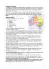
Estonia is located in the Northern Europe and is a state in the Baltic region It is bordered to the north by the Gulf of Finland, to the west by the Baltic Sea, to the south by Latvia, and to the east by Lake Peipus(Peipsi) and the Russian Federation.Estonia also has a number of islands: Saaremaa and Hiiumaa, which are the most known are also the two biggest ones.The territory of Estonia covers 45,227 km2. There is 3,794 kilometers of coastline marked by numerous bays, straits, and inlets. The Republic of Estonia is divided into fifteen counties: Hiiumaa, Saaremaa, Läänemaa, Harjumaa, Lääne-Virumaa, Ida-Virumaa, Tartumaa, Jõgevamaa, Järvamaa, Raplamaa, Viljandimaa, Pärnumaa, Valgamaa, Põlvamaa and Võrumaa. The capital city of estonia is Tallinn. Estonia is influenced by a temperate seasonal climate. Estonia has four seasons of near-equal length
GEOGRAPHY Estonia lies of the eastern coast of the Baltic sea. Total area of Estonia is approximately 45000 square kilometer and the population is about 1.5 million . Estonia is one of the most sparsely populated country in Europe. With 35 people per square kilometer. Nearly 1/3 of the nation live in the capital Tallinn. Along the coast of Estonia lies many bays and peninsulas. Lots of islands lie off the west- and north coast. The largest of them are Saaremaa and Hiiumaa. Geographically Estonia can be divided into 4 parts: North-, South-, West-, and East-Estonia. North-Estonia is relatively flat. Here is a nice coastline with coves, capes and a high coast. South-Estonia is more hillier, but there aren't any mountains or mountain ranges. The highest peak in Estonia is Suur Munamägi and its 318m above sealine. The largest industrial areas are situated in East-Estonia. There are beautiful nature parks in West-Estonia. The inland is mainly agricultural.
Alice Tärk, 9b Tallinn 2007 FACTFILE Area: 45 228 sq km Poplulation: under 1.4 million Capital: Tallinn Language: Estonian Currency: Eesti kroon (EEK) Main religion: Lutheran National holiday: 24 February (anniversary of the republic) National flower: Cornflower National bird: Barn Swallow National stone: Limestone LOCATION The Republic of Estonia is the northernmost and smallest of the three Baltic States. It is located on the eastern shores of the Baltic Sea in the north east of Europe. To the east the country borders Russia. Latvia is the countries neighbour to the south. From the west the coast of Estonia is washed by the Baltic Sea and from the north by the Gulf of Finland. The length of the coastline is approximately 3 800 km. The longest distance from east to west is 350 km, while north to south Estonia stretches 240 km. THE NAME
Facts and figures 3 Geography 3 Climate 3 Nature 4 History 5 Economy 6 Culture 6 Biggest towns 7 Language 8 3 Facts and figures The Republic of Estonia is a small country. Covering only 45, 228 sq km it is slightly bigger than Denmark, Belgium or Switzerland. Estonia's population is under 1.4 million. The official language is Estonian but since very many Russians live here Russian is also wide spread. The capital of Estonia is Tallinn. The currency used in Estonia is Eesti kroon. The Estonian national flag is blue-black-white. It was originally the flag of the Estonian Students' Society. The flag was first consecrated in Otepää Church in 1884. For a while, during the Soviet occupation, the flag was banned but it was again seen in public in Tartu in May 1988. The national flower is cornflower, the national bird is barn swallow and the national stone is limestone
Tallinn 2008 1. Introduction Estonia is a small country about the size of Switzerland, or New Hampshire and Massachussetts combined. Estonia is named after the people called "Ests" who lived in the region in the 1 st century AD. The Republic of Estonia is one of the three countries commonly known as the "Baltic States". The other Baltic States are Latvia and Lithuania. 2. Geographical position Estonia is situated in northeastern Europe. Estonia is bounded on the north by the Gulf of Finland, on the east by Russia, on the south by Latvia and on the west by the Baltic Sea. In the north it borders on Finland. The coastline of the Baltic Sea in Estonia is characterized by numerous gulfs and bays, the biggest of them being the Gulf of Finland, the Gulf of Riga and the Gulf of Pärnu. Bays include the Narva Bay, Matsalu Bay, Kolga Bay, Kunda Bay, Tallinn Bay etc. Estonia has over 1500 islands, the largest being Saaremaa and Hiiumaa, Muhu and Vormsi.
The old farmhouses and mansions can still be seen in many places in Southern Viljandimaa. As a result of the hard work and the tenacity of the local inhabitants, Mulgimaa developed into an area known as prosperous and rich by its cultural heritage. The masters working in the villages played an important role in the development. The local foods such as sauerkraut stew, curd cake and ,,kama" (a meal made with sour milk and a mixture of ground grains) are popular even nowadays. There is even a song that says: "It is good to live in Mulgimaa / The nature is beautiful and the land is fructuous/ There are glorious groves and large wealthy Estonian farms". As for now, the large-scale industry has become more and more dominating in agriculture. After thorough reforms in Estonian economy the people living in villages and small towns are searching for new possibilities for self-realisation and one of the outputs is tourism. This
Estonia. Estonia, officially the Republic of Estonia is a country in Northern Europe. It is the smallest of the three Baltic countries. Estonia has land borders with Latvia (339 km) to the south and Russia (229 km) to the east. It is separated from Finland in the north by the narrow Gulf of Finland and from Sweden in the west by the Baltic Sea. Estonia has been a member of the European Union since May 1, 2004 and of the NATO since March 29, 2004. The area of Estonia is about 45000 square kilometres and the population is about 1.4 million people. The capital of Estonia is Tallinn and the official language is Estonian. The currency is Eesti kroon. The main religion is Lutheran. Anniversary of the republic is celebrated on February 20. The national flower is cornflower, national
Estonia Where it is? Republic of Estonia is a state in the Baltic region of Northern Europe .It is bordered to the north by the Finland, to the west by the Baltic Sea, to the south by Latvia (343 km), and to the east by lake Peipus and Russia (338.6 km). Across the Baltic Sea lies Sweden in the west and Finland in the north. Towns Tallinn is the capital and the largest city of Estonia. It lies on the northern coast of Estonia, along the Gulf of Finland. There are 33 cities and several town-parish towns in the country. In total, there are 47 linna, with "linn" in English meaning both "cities" and "towns". More than 70% of the population lives in towns. History • Estonia was settled near the end of the last glacial era, beginning from around 8500 BC
Võnnu Keskkool ESTONIA Referaat Autor: Klass : 9 Juhendaja: Võnnu 2013 Estonia officially the Republic of Estonia, is a state in the Baltic region of Northern Europe It is bordered to the north by the Gulf of Finland, to the west by the Baltic Sea, to the south by Latvia and to the east by Lake Peipus and Russia.Across the Baltic Sealies Sweden in the west and Finland in the north. The territory of Estonia covers 45,227km2 The Estonian climate resembles that of other countries on the Baltic littoral. On account of the country's proximity to the sea, the skies are often cloudy, and rain often falls in the spring and autumn, in the winter the rain turns to snow. The highest point in Estonia is Suur Munamäg It is in fact the highest point in the Baltic region Forest cover over one half of Estonia. The most common types of tree are pine, spruce and birch
Estonia Estonia lies in the North-Europe and it is the member of European Union. In the north, Estonia is washed by the Gulf of Finland, in the west by the Balic Sea, in the south there is Latvia and in the east there lies Russian Federation. The territory of Estonia is 45,227 km 2 and it is divided into 15 counties. The capital and also the largest city in Estonia is Tallinn. The population is not large only 1.3 million people. The official language is Estonian. Although we have only few speakers in word terms, we are proud of our language which is considered to be one of the world's most beautiful ones. Estonia is an independent country, the
Estonian geography The territory of Estonia covers 45,227 km2. Estonia is situated in the Baltic Region of Northern Europe. It is bordered to the north by the Gulf of Finland, to the west by the Baltic Sea. Its neighbor countries are to the south Latvia, to the east Russia, to the north and over the Gulf of Finland, Finland and to the west and over the Baltic Sea, Sweden. Most of the lowland areas are in the middle of Estonia. Average elevation reaches only 50 meters and the country's highest point is the Suur Munamägi in the southeast at 318 meters. There is 3,794 kilometers of coastline marked by numerous bays, straits, and inlets. The number of islands and islets is estimated at some 1,500. Two of them are large enough to constitute separate counties: Saaremaa and Hiiumaa. A small, recent cluster of meteorite
The Republic of Estonia Estonia officially the Republic of Estonia is a country in the Baltic region of Northern Europe. It is bordered to the north by Finland across the Gulf of Finland, to the west by Sweden across the Baltic Sea, to the south by Latvia and to the east by the Russian Federation. The territory of Estonia covers 45,227 km² and is influenced by a temperate seasonal climate. Estonia is a democratic parliamentary republic and is divided into fifteen counties. The capital and largest city is Tallinn. With a population of only 1.4 million, it is one of the least- populous members of the European Union. Estonia was a member of the League of Nations from 22 September 1921, has been a member of the United Nations since 17 September 1991,
to the end of the independency period. 2. The Tallinn Song Festival Grounds The Tallinn Song Stage was built in 1959 for arranging the Song Festivals. The stage was meant to hold over 15 000 singers. Indoor rooms can be used as a backstage area during the concerts but those are also suitable for all kind of events, parties, concerts, 2 banquettes, fairs, exhibitions etc.In the northern side of the song stage there is 42 m high fire tower, which is used during the famous Song Festivals. It is also opened for the public all year long. 3. Kiek in de Kök tower The cannon tower Kiek in de Kök was founded in 1475-1483. In 1696 the present name Kiek in de Kök was also
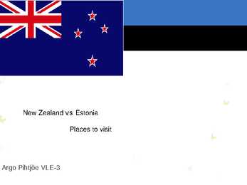
destinations Rotorua Famous for its volcanic activity. Every reserve has spectacular examples of geysers, boiling pools, hot springs, boiling mud, volcanic terraces, and craters. Mt Tarawera nearby volcano offers spectacular scenery including superb views inside the rim of the volcano Best area in the country to experience and learn about Maori Culture. Top ten places to visit in New Zealand Bay of Islands Bay of Islands is the finest maritime park in New Zealand. There are about 150 islands. The park has an abundance of marine life, including marlin, whales, penguins and dolphins. Mt Cook National Park Mt Cook and surrounding area is an alpine park within the South Westland World Heritage area. Mt Cook, Mt Tasman and Mt Sefton. This glacier is New Zealand's longest and it has one of longest ski runs in the world. Top ten places to visit in
Estonia lies on the eastern shores of the Baltic Sea on the level northwestern part of the rising east European platform. Estonia is a flat country covering 46 226 square kilometers.Estonian's neighbours are Finland, Sweden, Latvia and Russia. Estonia is rich in islands. The two largest are Saaremaa and Hiiumaa . Saaremaa is famous for its big meteorite crater called Kaali and Hiiumaa is famous for its nature and plants. The countries highest point Big Egg hill ( Suur- Munamägi) reaches 318 meters above sea level. Estonia has many uplands too. The uplands are: Pandivere upland, Otepää upland, Vooremaa upland, Karula upland Haanja upland, Sakala upland. Estonia is covered by about 18 000 square kilometers of forest. Estonia is also rich in lakes and rivers The largest lake is Peipsi and the second-largest lake is Võrtsjärv
The highest and most topographically variagated region in Estonia is in the south-eastern part of the country. The Sakala Upland plains offer contrast to the hills of Ottepää, Karula and Haanja. At 318 metres, Suur Munamägi ('Great Egg Hill') is not only the highest point in Estonia, but of all the Baltic countries. The country has 3974 km of coastline, while the land border, in comparison, is only a mere 633 km. The coast varies from limestone cliff in the north to sandy beaches in the west. Most of Estonia's many islands belong to the West Estonian archipelago. The largest islands are Saaremaa with 2671 sq km, Hiiumaa with 989 sq km and Muhu with 200 sq km. The sea between these islands and the Mainland Väinameri is very shallow (less than five metres deep on average) and rich in shoals. The water of the Baltic Sea is brackish. Its average saltinity is only one fourth of that of the sea in general. Thus, most Estonian freshwater fish (about 30 species) also inhabit the sea
Legislative assembly/ 'ledsltv 'sembl/ seadusandlik kogu The British Isles is the name of a group of islands washed by the North Sea in the east and the Atlantic Ocean in the west. The British Isles are shared by two separate and independent countries: the
Estonia Estonia is a small country in Northern Europe with an area of about 45 000 sq km. As a part of the East-European Plain, the country has a rather flat surface. The highest and most diverse region in Estonia is in the south-eastern part of the country. At 318 metres, Suur Munamägi is not only the highest point in Estonia, but of all the Baltic countries. There are about 1500 islands in Estonia, the biggest of which being Saaremaa and Hiiumaa. Sixty-four species of mammals have been recorded in Estonia, three of them have been introduced: the racoon dog, the American mink and the muskrat. A couple of species have been re-introduced The European beaver, who was hunted to extinction by the end of the 19th century. A vital population of them now exists in Estonia once again. Another re- introduced species is the red deer. An attempt has been made in Estonia in recent years to disperse the population of wolves,
So, Australia is both a country and a continent. If you want to make clear that you are speaking about the country, you may call it the Commonwealth of Australia. It’s the official name of the country. Australia is the smallest continent, but one of the largest countries on Earth. It’s 6th largest country. Its area is about 7.6 million sq km. One third of it is occupied by deserts. It’s both the flattest and, except for Antarctica the driest. Neighbouring countries include Indonesia, East Timor and Papua New Guinea in the north, the Solomon Islands, Vanuatu in the northeast, and New Zealand in the southeast. Its capital is Canberra. Other big cities are Melbourne, Sydney, and Brisbane. National language in Australia is English. Monetary unit is Australian dollar. Their national holiday is on the 26th of January. In 1788 on the 26th of January the first fleet arrived at Botany Bay and established a penal colony near modern-day Sydney. Geographical Position
up another 8% of the overall production and which employ more than 7% of the workforce. The larger part of the output of Estonia's forestry and related industries goes for export, whereas Estonia increasingly exports goods of a higher value. The production and export of wooden construction details, wooden furniture and wooden houses has been going up consistently. The main export destinations are Finland, Sweden, Germany, Norway and Great Britain. Timber companies are located all over Estonia, a number of them in small towns or even in villages. The most important branch among processing industries in Estonia is timber, paper and furniture industry. Second comes the food processing industry, mostly in the form of meat and milk producing, but the production of drinks, bread and confectioneries is also substantial. Food industry that has undergone huge changes during the recent years, offers quite varied products. Estonians love locally produced food,
My Town I live in Tallinn. It's the capital and main seaport of Estonia. Tallinn is a very beautiful city that lies on the Baltic Sea. It covers 158 square kilometres. The Mayor of Tallinn is Jüri Ratas. The population of our capital is about 400000 people. About 55% of them are Estonian, 37% Russians and the other 8% are from different nations. The people here are mostly engaged in industry- mainly the food industry (23%), trade (16%) and transport and communication (14%). History. Tallinn has a great history. It was first marked on a map of the world by the Arab geographer al-Idrisi in 1154, its name then being Kolyvan. In the 13 th- century chronicle of Henricus de Lettis the town was called Lyndanise. Then it was called Reval for some time and finally Estonians started to call the town Tallinn from
Virginia, in the eastern part of the U.S.A. The biggest cities are New York, Washington, Chicago, Los Angeles, San Francisco, etc. The flag of America was adopted on 14 th June 1777. It is called the "Stars and Stripes". It is said that Betsy Ross sewed the first flag. It features 13 horizontal red and white stripes (for the first colonies which formed the U.S.A.) and 50 stars on the blue background. Red means courage, blue justice and white innocence. There is a star for every state of the USA. The official language of the USA is English; Spanish is also widely spoken. The currency of the USA is the United States Dollar. The government of the USA is composed of three coordinate branches: the executive, legislative and the judicial. All the three branches are equal. The executive power is vested in the president, who holds office for a term of four year. At the moment George W. Bush is the president
and it is bordered by three oceans: the Arctic, the Pacific and the Atlantic Oceans. The population of Canada is about 31 million people. About 77% of the people live in cities which lie in a band about 100 miles wide above the border of the United States. The capital of Canada is Ottawa. Other large cities are Montreal, Toronto, Vancouver, Winnipeg and Quebec. 2. Geographical position Canada is a huge country in the continent of North America. It is bordered with the Atlantic Ocean in the east, the Pacific Ocean in the west, the United States of America in the south and the Arctic Ocean in the north. Canada is a vast country, with a territory of 3.8 million square miles of land and fresh water it is the second biggest country in the world after Russia. Canada covers most of the northern part of North America. Canada has over 151,480 miles of coastline
Introduction Estonia, officially the Republic of Estonia (Estonian: Eesti or Eesti Vabariik) is a country in the Baltic region of Northern Europe. It is bordered to the north by Finland across the Gulf of Finland, to the west by Sweden across the Baltic Sea, to the south by Latvia (343 km), and to the east by the Russian Federation (338,6 km). The territory of Estonia covers 45,227 km² and is influenced by a temperate seasonal climate. The Estonians are a Finnic people closely related to the Finns, with the Estonian language sharing many similarities to Finnish. The modern name of Estonia is thought to originate from the Roman historian Tacitus, who in his book Germania (ca. AD 98) described a people called the Aestii. Similarly, ancient Scandinavian sagas
Canada. Canada is a very big country in the continent of North America. It is about 10 million square kilometres and that makes it the second largest country in the world after Russia. Quebec (the province) is six times as big as the UK. Canada borders the Atlantic Ocean, the Pacific Ocean, the Arctic Ocean and the USA. The capital of Canada is Ottawa and other main cities are Toronto, Montreal and Vancouver. It is a very developed country. Montreal is the largest city and it is called the Paris of North America because most of the people there speak French
The official name of the country is the United Kingdom. The United Kingdom is an island country. It consists of the island of Great Britain and Northern Ireland. Great Britain can be divided into three parts England, Wales and Scotland. Each of them has their own capital city. Glasgow in Scotland, Cardiff in Wales and London in England. The country is situated in the north-western Europe. The territory of the United Kingdom is about 244,000 square kilometres and about 60 million people live there. The UK contains a number of small islands. The largest islands that belong to the United Kingdom are the Isle of Man in the Irish Sea and the Isle of Wight which lies off of England's southern coast. The largest groups of islands are the Shetland Islands, the Orkney Islands and the Hebrides. Geographical Position The UK is situated in the Northern Hemisphere. The United Kingdom is bordered by the Atlantic Ocean in the west, the North
Oceans. The population of Canada is about 31 million people. About 77% of the people live in cities which lie in a band about 100 miles wide above the border of the United States. The capital of Canada is Ottawa. Other large cities are Montreal, Toronto, Vancouver, Winnipeg and Quebec. Canada has two official languages English and French. It's interesting to know that about 61% of Canadians name English and 24% French their mother tongue. There are also many other languages spoken in Canada such as: Italian, Chinese, German, Polish, Ukrainian, Greek and Dutch. There are also many native languages such as Algonquian. The British and the French as the main settlers from Europe fought for hundreds of years before they managed to build up a country which was based on recognizing the cultural diversity of different nations in Canada. All the communities living in the
The total population of Estonia is 1 313 271 according to Statistics Estonia, of which 69.1% are Estonians, 25.1% Russians, 4.9% of which are of different nationalities for example Ukrainians, Belarusians and Finns. Rest are of unknown nationality. 68.5% of population speaks Estonian as a mother language, 29.6% speaks Russian as a mother language and 0.6% Ukrainian. Estonia has only one official language which is Estonian. According to information by the Institute of the Estonian Language there are about 75% of Estonian people who speak Estonian. The most common foreign languages learned by Estonian students are English, Russian, German and French. Other popular languages include Finnish, Spanish and Swedish. Tallinn is the capital and largest city of Estonia. In Estonia there are 47 cities/towns. More than 70% of the population lives in towns. The largest cities are Tallinn, Tartu, Narva, Pärnu. According to the information from tallinn
......................................................................7 10. History..........................................................................................................8 11. Conclusion....................................................................................................9 12. References....................................................................................................10 Introduction I chose finland because there are friendly people and beautiful nature. Finland is bigger than Estonia. There lives over 5 milj. people. Finland capital is Helsingi and there lives about 2 milj. people. Highest top is 1328m. Finland is bordersed with Sweden to the west, Russia to the east and Norway to the north. It is the eight largest city in Europe. Most Finns speak Finnish. The second language is Swedish. Finland is rated the sixth most peaceful country in the World. In Finland there are more than 60000 lakes.
Introduction, Location Australia is a country between the Indian Ocean and the Pacific Ocean. It is the only country in the world that occupies an entire continent. The mainland covers an area of 7.7 million km² and it is about 3700 km from the most northern point to its most southern point and about 4000 km from east to west. There are also many different seas around Australia, like the Coral and the Tasman Seas in the west or the Timor and the Arafura Seas in the north, where the Indian and the Pacific Oceans meet. Because all seas and oceans near Australia are warm, surfing is a very popular hobby. Political subdivision Australia is divided into six states, which are: · New South Wales · Victoria · Queensland · South Australia · Western Australia · Tasmania New South Wales is the most populous state in Australia. Its capital is Sydney. Victoria is one of the most densely populated states in Australia. Its capital city is Melbourne
Geography Canada is the world's second largest country in total area after Russia , since it covers nearly 10 million square kilometres, but is one of the most sparsely populated, with only about 34 million inhabitants. The majority of them live within 300 kilometres of Canada's southern border. Much of the rest of Canada is uninhabited or thinly populated, because the country has a rugged terrain and severe climate. Canada extends across the continent of North America, from Newfoundland on the Atlantic coast to British Columbia on the Pacific coast and northward into the Arctic Ocean. Canada shares land borders with the United States to the south and north-west. Canada is a land of great variety. Towering mountains, crystal-clear lakes, and lush, green forests make Canada's far west a beautiful region. Farther inland, fields of wheat and other grains cover Canada's vast prairies
The United Kingdom The United Kingdom consists of England, Scotland, Wales and North Ireland and it is situated in the Atlantic Ocean near the mainland of Europe. The population of the UK is 58.6 million and area is 244,110 sq km. Britain has a temperate humid climate. Its characteristic features are mild winters, warm summer, no temperature extremes, abundant rain all year round and frequent changes of weather. The mild climate is partly due to the warm Gulf Stream and partly to the south westerly winds. Occasional winds from the east in winter may